Download Agreement, Release, and Acknowledgement of Risk:
You (the person requesting this file download) fully understand mountain climbing ("Activity") involves risks and dangers of serious bodily injury, including permanent disability, paralysis, and death ("Risks") and you fully accept and assume all such risks and all responsibility for losses, costs, and damages you incur as a result of your participation in this Activity.
You acknowledge that information in the file you have chosen to download may not be accurate and may contain errors. You agree to assume all risks when using this information and agree to release and discharge 14ers.com, 14ers Inc. and the author(s) of such information (collectively, the "Released Parties").
You hereby discharge the Released Parties from all damages, actions, claims and liabilities of any nature, specifically including, but not limited to, damages, actions, claims and liabilities arising from or related to the negligence of the Released Parties. You further agree to indemnify, hold harmless and defend 14ers.com, 14ers Inc. and each of the other Released Parties from and against any loss, damage, liability and expense, including costs and attorney fees, incurred by 14ers.com, 14ers Inc. or any of the other Released Parties as a result of you using information provided on the 14ers.com or 14ers Inc. websites.
You have read this agreement, fully understand its terms and intend it to be a complete and unconditional release of all liability to the greatest extent allowed by law and agree that if any portion of this agreement is held to be invalid the balance, notwithstanding, shall continue in full force and effect.
By clicking "OK" you agree to these terms. If you DO NOT agree, click "Cancel"...
A Nickel of Cents in the San Juans - Part 1 - The Wilson Group
Morning view on Wilson Peak's False Summit, climbers at bottom right
Peaks (In order of summit):
8/30 - Wilson Peak - 14,017' (R#48), Gladstone Peak - 13,913' (R#67),
8/31 - El Diente - 14,159' (UR ~#24), Mt Wilson - 14,246' (R#16) TH/Route:ROA/Silver Pick,
8/30 - Wilson Peak: West Ridge Direct, Gladstone Peak: North Ridge Traverse
8/31 - El Diente: North Buttress, Mt Wilson: traverse from El Diente (1:15), descent via NE ridge (standard) Climbers: Climbed with group of 4 on Wilson Peak, Solo on all other peaks/routes. Weather: Normal Monsoon conditions, clear in morning storms by afternoon
Due to a weeklong Boy Scout backpacking trip in the Elk Mountains in July, I hadn't had a chance to get out and continue my quest for the Centennial
peaks since I climbed Organ/San Luis/Stewart in early June. I broached the idea to my wife of getting some "further away" peaks over the Labor Day
weekend, and she very kindly said "Okay". As Labor Day weekend came into the NOAA forecast window, the weather for the Wilson's area looked absolutely horrid,
and my hopes of getting these 5 peaks plummeted. As the weekend neared though, the forecast improved and changed into a normal "monsoon" forecast
with clear mornings and afternoon thunderstorms.
Scott Farish had contacted me about joining his group of 4 to do Wilson Peak and so we started off from the ROA/Silver Pick TH at 4:30AM on Friday.
The ~4mi up to the pass went quickly in the darkness and we arrived at the pass around 6:45am. Here we rested for 20min or so and then
began the traverse up to the red saddle. From here I scrambled up the West Ridge Direct Route while they chose to traverse across the talus.
The direct route was solid and fun except for one very steep gully I had to cross.
Crossing the harder section on Wilson Peak. Climbers visible
I stayed on the ridge crest until the false summit and waited for the other guys there. Then we descended down across the notch and up to
Wilson Peak's summit, which we reached exactly an hour from the ROA saddle.
Scott Farish and crew gain Wilson Peak's summit
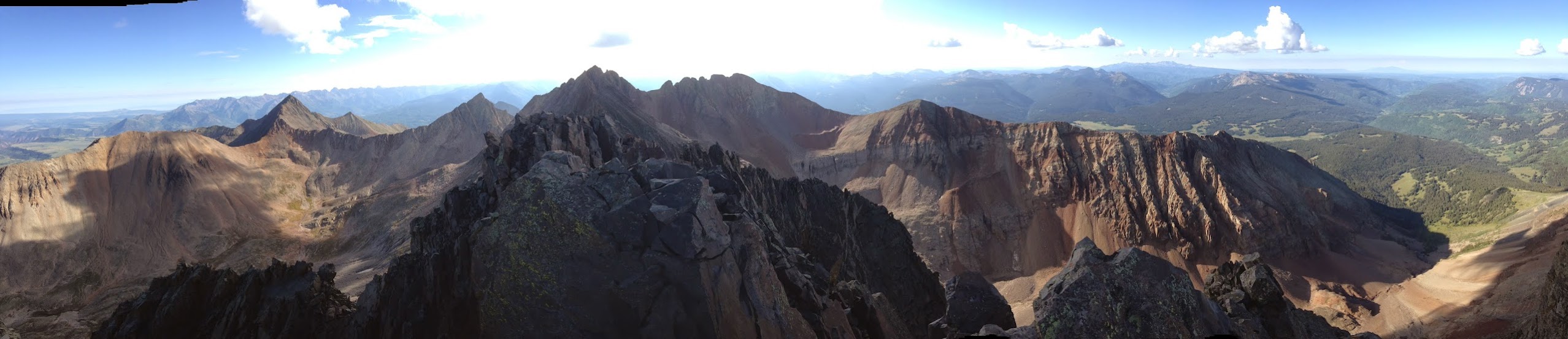
Panorama from summit of Wilson Peak
For about an hour we enjoyed the spectacular views from the summit and enjoyed the increased warmth as the high clouds that had been
there all morning finally cleared. We then began our descent back across to the false summit.
Coming back across the harder section. Climbers visible
After waiting to make sure everyone made it across safely I separated from the group and headed towards Gladstone Peak's North Ridge.
Pretty light on El Diente and Navajo Basin
JosephG's very helpful recent TR for Gladstone Peak was in my head the whole way across the traverse. I followed his advice and stayed
on the crest of the ridge or within 20' or so the entire way across.
Looking back at Wilson Peak while traversing Gladstone Peak's North Ridge
The scrambling was fun and mostly solid Class 3 with some isolated Class 4 moves if you wanted them. It took me about 2hrs to do the traverse
whereupon I summited 13,931' Gladstone Peak and enjoyed the jaw-dropping views that surrounded me.
Panorama from summit of Gladstone Peak
I relaxed on Gladstone's summit for about 45mins and then began my descent. Prior to this climb I had investigated, via Bill's great Mt Wilson Panorama,
a gully that started near Gladstone's summit and descended directly down to the glacier. As I looked down the gully the top 30' or so was steep solid rock
that turned into talus the rest of the way down. YES! Towards the bottom the gully splits around a buttress and I took the left branch
which took me down to the glacier. The right branch was very doable too.
Looking down descent gully on Gladstone Peak
Looking back up descent gully
At bottom of gully and on glacier looking back up.
Looking towards ROA saddle from glacier
Gladstone Peak w/ large descent gully marked.
After crossing the glacier I climbed up to the 13,400' bench on Mt Wilson's NE Ridge Standard Route. It was now only 1:00PM and I was still feeling great.
I stood there on the bench for 20mins or so and was VERY tempted to go up and try to snag Mt Wilson since it was only 800' elevation gain from where I was.
If it had been a "bluebird" day I certainly would've have gotten Mt Wilson and done the traverse over to El Diente. Which would have elevated this day
to "BIG DAY" status... But, as I looked up at the darkening clouds I made the decision to not risk it and just head down to the basin and camp
by a small lake dammed up by the talus cone coming down from El Diente's North Slopes Route "death" gully.
Looking down Navajo Basin from ~13,400 on Mt Wilson NE ridge route. The lake I camped at is seen at bottom.
Just after I set up camp the rain started and it rained off-and-on until 4PM as I napped in my tent. After the rain stopped I hung out and lounged around
enjoying the serene upper Navajo Basin.
Panorama from campsite in upper Navajo Basin
Hail on Delores Peaks
I set the alarm for 5:30am and slept peacefully under the bright stars and on top of the loamy tundra.
After the alarm went off I got ready, cooked breakfast, and packed everything up. Just as I was starting out around 7AM alpenglow began to hit the summit of El Diente.
Alpenglow on El Diente
I used the same route alpiner84 used to get to El Diente's North Buttress route by heading up the talus cone above the lake and then traversed
on the grassy ledge and then talus in order to intersect the North Buttress Route on El Diente around the "Second Bench" and right below the "big hump".
Looking up North Buttress on El Diente
Once on the North Buttress Route, the scrambling was solid and I noticed two guys up ahead of me. I caught them at the 3rd Bench and we talked
about the exit options to the summit ridge. They told me about the right hand option as opposed to the normal "slab" route. This is the route I ended up choosing.
Looking down North Buttress Route on El Diente
I reached the summit of El Diente around 9:15AM making it a 2hr ascent. It was a fun and very exhilarating route that I would love to do again!
The view and solitude on the summit was just incredible.
On El Diente summit looking at ridge on south side of Kilpacker Basin
Light and Shadow on Wilson Peak
Panorama from El Diente Summit
I couldn't stay to long (~30min) as the clouds were building quickly over Mt Wilson and I still had the traverse to do. So I called my wife and let her
know that I would check in w/ her once I reached Mt Wilson's summit in 1.5 - 2hrs or so. Well, little did I know that it would only take me 1:15 to do the very fun
and thrilling traverse!
Looking back at El Diente while on traverse
Looking ahead at Mt Wilson during traverse
I passed a group of 4 near the last notch before Mt Wilson's summit, one of whom is 14ers.com member DanielL, and reached the Mt Wilson's
lofty summit at 11AM. After DanielL's group made it to the summit another group of 3 guys who had done the standard NE ridge route arrived at the summit.
Man! It's getting crowded up here!
El Diente - Mt Wilson Traverse from Mt Wilson summit
Gladstone Peak and Wilson Peak from Mt Wilson summit
What a poser...he even has a pillow strapped to his backpack...
Looking towards tomorrows objective: Vermilion Peak 13,894'. It's the one with the little puffy white cloud above it
Panorama from Mt Wilson Summit
Fortunately, the dark clouds that had been building held off for awhile and I was able to stay on the summit for about an hour, leaving the summit at 12PM.
We descended the NE ridge route and it showered on me a couple of times as I made my way across the basin and up to the ROA saddle.
Descending Mt Wilson NE Ridge (standard) route
Gladstone Peak, Glacier, and Mt Wilson
There was a group of 4 people there at the saddle that was cooking lunch and kindly offered me some dried mango slices. YUM!
I didn't want to stay too long as the clouds kept getting darker and I knew I still had the 4mi to the TH to go. So I headed down after 10min
and enjoyed the beautiful views northward.
Silver Pick Basin
Storms finally hit on ROA saddle
It finally did pour rain and graupel on me for 10mins or so right before I got to treeline. As I neared the TH I caught up with 14ers.com member fepic1
who had taken a woman up Wilson Peak that day for her 2nd 14er after Huron Peak! Way to go!
As I was getting ready to leave fepic1 was firing up his charcoal grill to cook some burgers and graciously offered me some, but I just wanted
to be somewhere warm and dry so I had to decline. I headed to Telluride for dinner and then headed over to Trout Lake and up to the Hope Lake TH
for Cent #5 on the weekend, Vermilion Peak. Trip report for that peak is here.
Wilson Peak and Gladstone from along highway
Trusty Scooby-Doo parked at Hope Lake TH with Vermilion Peak (13,894') overhead
Thumbnails for uploaded photos (click to open slideshow):
I can imagaine how tempting it must have been to want to get Mt. Wilson that first day from the bench at 13,400. We thoroughly enjoyed climbed that route several weeks ago. Probably a good decision though, as that nasty weather rolled in right around 12:30/1:00. We were just back to the car when the skies opened up.
Thanks for the teamwork on Wilson Peak. We had fun climbing with you - and there was no mistaking you with that big pillow on your back
It looked like your next day went exceptionally well too. We were summitting Sneffels right about the same time that day. Could you see us on the summit in our ”improvised climbing attire”? ;)
How did you get your panos so big that you have to scroll across? Linked to something?
I think I would like to try that with some of my panos that I sometimes include in my reports.
Nice job on this group and Vermillion. Gladstone's a fun peak--glad my TR helped!
Caution: The information contained in this report may not be accurate and should not be the only resource used in preparation for your climb. Failure to have the necessary experience, physical conditioning, supplies or equipment can result in injury or death. 14ers.com and the author(s) of this report provide no warranties, either express or implied, that the information provided is accurate or reliable. By using the information provided, you agree to indemnify and hold harmless 14ers.com and the report author(s) with respect to any claims and demands against them, including any attorney fees and expenses. Please read the 14ers.com Safety and Disclaimer pages for more information.
Please respect private property: 14ers.com supports the rights of private landowners to determine how and by whom their land will be used. In Colorado, it is your responsibility to determine if land is private and to obtain the appropriate permission before entering the property.


 route")


 overhead")
 Morning view on Wilson Peak's False Summit, climbers at bottom right")
 Crossing the harder section on Wilson Peak. Climbers visible")
 Scott Farish and crew gain Wilson Peak's summit")
 Pretty light on El Diente and Navajo Basin")
 Coming back across the harder section. Climbers visible")
 Looking back at Wilson Peak while traversing Gladstone Peak's North Ridge")
 Looking down descent gully on Gladstone Peak")
 Looking back up descent gully")
 At bottom of gully and on glacier looking back up.")
 Looking towards ROA saddle from glacier")
 Gladstone Peak w/ large descent gully marked.")
 Looking down Navajo Basin from ~13,400 on Mt Wilson NE ridge route. The lake I camped at is seen at bottom.")
 Hail on Delores Peaks")
 Alpenglow on El Diente")
 Looking up North Buttress on El Diente")
 Looking down North Buttress Route on El Diente")
 On El Diente summit looking at ridge on south side of Kilpacker Basin")
 Light and Shadow on Wilson Peak")
 Looking back at El Diente while on traverse")
 Looking ahead at Mt Wilson during traverse")
 El Diente - Mt Wilson Traverse from Mt Wilson summit")
 Gladstone Peak and Wilson Peak from Mt Wilson summit")
 What a poser...he even has a pillow strapped to his backpack...")
 Looking towards tomorrows objective: Vermilion Peak 13,894'. It's the one with the little puffy white cloud above it")
 Descending Mt Wilson NE Ridge (standard) route")
 Gladstone Peak, Glacier, and Mt Wilson")
 Silver Pick Basin")
 Storms finally hit on ROA saddle")
 Wilson Peak and Gladstone from along highway")
 Trusty Scooby-Doo parked at Hope Lake TH with Vermilion Peak (13,894') overhead")

