Download Agreement, Release, and Acknowledgement of Risk:
You (the person requesting this file download) fully understand mountain climbing ("Activity") involves risks and dangers of serious bodily injury, including permanent disability, paralysis, and death ("Risks") and you fully accept and assume all such risks and all responsibility for losses, costs, and damages you incur as a result of your participation in this Activity.
You acknowledge that information in the file you have chosen to download may not be accurate and may contain errors. You agree to assume all risks when using this information and agree to release and discharge 14ers.com, 14ers Inc. and the author(s) of such information (collectively, the "Released Parties").
You hereby discharge the Released Parties from all damages, actions, claims and liabilities of any nature, specifically including, but not limited to, damages, actions, claims and liabilities arising from or related to the negligence of the Released Parties. You further agree to indemnify, hold harmless and defend 14ers.com, 14ers Inc. and each of the other Released Parties from and against any loss, damage, liability and expense, including costs and attorney fees, incurred by 14ers.com, 14ers Inc. or any of the other Released Parties as a result of you using information provided on the 14ers.com or 14ers Inc. websites.
You have read this agreement, fully understand its terms and intend it to be a complete and unconditional release of all liability to the greatest extent allowed by law and agree that if any portion of this agreement is held to be invalid the balance, notwithstanding, shall continue in full force and effect.
By clicking "OK" you agree to these terms. If you DO NOT agree, click "Cancel"...
It probably seems lame that an easy, Class 1 walk-up has overtaken some of my more challenging summits as my "favorite" 14er, but I absolutely loved this hike! For those of you thinking about what 14er to finish on, I would highly recommend San Luis Peak. It is easy enough for friends and family to hike with you, but is also scenic, fun, and interesting. I kept thinking while I was on the trail: "Boy, Dad would love this hike," "Man, my brother would love this hike," "Geez, my nephews would love this hike." Even with the long drive to get there, I will definitely be repeating San Luis Peak.
I spent the night at the Windy Point overlook on CO-149 near Lake City. I awoke at 5:15 on July 5th and had my breakfast and coffee while watching the morning light shine upon Wetterhorn and Uncompahgre. It was a great way to wake up, although in hindsight I probably dallied a bit too long there, which led to a later start than I would've liked on San Luis Peak. I left Windy Point at 6:30 and drove toward Creede along CO-149, one of the most pleasant drives I've taken in Colorado. I saw some deer along the way, took in some majestic mountain views, and stopped briefly at the headwaters of the Rio Grande.
I arrived in Creede at around 7:50. I was pretty pumped to be in the town of Creede. I'm a huge John Wayne fan, and I've wondered what Creede was like ever since I saw the scene in which the Duke mentions seeing a doctor in Creede at the beginning of "The Shootist." Well, I wasn't disappointed. Creede has to be the neatest old mining town in the state. I could just picture what it must've been like during the mining boom. And I had no idea that Robert Ford, the guy who shot Jesse James, is buried there. Certainly a lot of "Old West" history there.
Well, after making a quick drive through Creede for a look I started driving toward the trailhead. I usually find Gerry Roach's directions pretty good, but in this case they were outdated. He mentions "three dirt roads" in his 2WD directions to the trailhead, but one of the roads (the one you need to take) is actually now paved. His directions got worse from there. I also had the Trails Illustrated and USGS maps of the area. These were next to worthless as well; some roads on the map didn't exist, and other roads that existed weren't on the map. However, at least I could pick up major geographic features from the topos. I was surprised that there is not a single sign for "San Luis Peak" on any of the roads, but I guess that adds to the adventure. There were hundreds of old mines with picturesque names dotting the landscape. I felt like I was lost practically from the time I left Creede until I arrived at the Equity Mine, but I amazingly made it there without ever making a wrong turn. Either my instinct was good or, more likely, I was lucky. (FYI, you basically just want to follow 504 north to 503, then turn left and follow 503 all the way to the Equity Mine).
Dawn, looking west from the Windy Point overlook on CO-149.
Uncompahgre is one magnificent 14er.
I got to see a bit of wildlife along CO-149.
Headwaters of the Rio Grande.
Downtown Creede. I would've loved to have seen this place in its heyday!
I was at the Equity Mine at 8:40. After quickly applying sunscreen and making two sandwiches, I hit the trail at 9:00. The first section just follows the 4WD road north, then turns northeast onto an older 4WD road which leads up to a saddle just southeast of the prominent Point 12,540. The steep section leading up to the saddle is one of only three sections of the entire route that I would describe as moderately strenuous. The saddle, which I reached at 10:00, provided great views of San Luis Peak's west face, and this is where the route got really enjoyable. From the saddle I followed the Colorado Trail down through a small section of forest and then up to another saddle. From this second saddle, which I reached at around 11:00, the trail contours around a wide basin. You can fly through this section"it's nearly flat as a sidewalk the entire way. It was on this contour that I ran into my first fellow hiker, who was resting against a rock about half-way around the basin.
Eventually the trail begins to rise again to a third saddle. From this saddle, you need to climb up another steep slope to attain the crest of the south ridge of San Luis Peak. This is the second part of the route that I would describe as moderately strenuous. On my way up, I ran into two other hikers on their way down. By the time I reached the top of the ridge at around noon, I started to worry about the darkening clouds. I ran into one more hiker coming down from the summit, the last of the four people I would see all day.
San Luis Peak from the saddle southeast of Point 12,540.
Following the Colorado Trail.
Contouring around the basin. The south ridge of San Luis Peak is on the left.
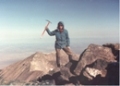
When I reached 13,250 feet, I started to become more and more concerned with the stormclouds that were gathering. Being on the very top of an exposed ridge, 6 feet taller than anything else, is definitely not where you want to be during a thunderstorm. I sat down for a few minutes and examined the clouds and wind. There were a few extremely distant peals of thunder, but I hadn't seen any lightning strikes yet. I felt fairly safe in continuing up to the summit. Nevertheless, I moved about as quickly as I could up and down that ridge! I made the summit at 12:45, took a couple of photos, and then hustled back down the ridge.
It started to rain lightly once I was off the ridge, but the thunder and lightning never did materialize. Even with the rain, the hike back was still beautiful. Hiking from the forest back up to the saddle southeast of Point 12,540 was the third and final "moderately stressful" section. I was back at my car at 3:50.
Nearing the summit.
Looking back down the south ridge. The approximate route is shown in red.
A parting view of San Luis Peak.
I can think of four reasons why I enjoyed this hike so much. First, San Luis Peak is nestled in a remote and absolutely stunning area. Second, for most of the route you can see your objective, which always makes things more enjoyable for me. Third, rather than constantly gaining altitude like most 14er hikes, this route fluctuates between sections of gaining altitude, dropping altitude, and staying flat. This is both physically and mentally refreshing. Finally, the south ridge is a playful little walkup"quite good fun to trek up.
On my drive back to Denver I stopped at "True Grits" steakhouse in Alamosa for some John Wayne-themed food. I had "The Duke", a 20 oz. New York strip. They know how to do steak there! I'm disappointed at most restaurants when I order a large, rare steak (usually it is burnt on the outside and raw in the middle). This baby was cooked to absolute perfection. The peach pie for dessert wasn't bad either.
I got back to Denver at around 11:30 at night. My three-day Independence Day trip had been successful: four 14er summits (Columbia, Sunshine, Redcloud, and San Luis), a total of 39.5 miles hiked, and a total vertical elevation gain of about 17,300 feet (3.25 miles!). Needless to say, I slept incredibly soundly that night.
Standard south ridge route (click to enlarge).
Thumbnails for uploaded photos (click to open slideshow):
I'll have to consider this for a ”finisher”. If I ever get that far. Glad to hear your excitmement about it. Nice pictures but would have liked to see one of that steak! Welcome back.
I love your enthusiasm and exuberant joy for this gorgeous peak. It's always been a favorite of mine for the remote solitude, pristine beauty, and colorful terrain. Great trip report, with sweet photos. Makes me want to return to this beauty again. I've climbed it twice from the Skyline Trail to the north and would do it again in a minute. Thanks for sharing this fun adventure!
Not lame at all - the S route from W Willow Creek TH is a gem.
I have a soft spot for San Luis, too.
Got to enjoy San Luis' serene, soothing effects the day after a foray up Lake Como Rd (say no more, eh??) last year.
Also saw a black bear up there and an ermine. Very cool, and an awesome place! Glad you got to soak it up!
Nice TR! Congrats on 4 summits!!
Also made a note to self re: your steak recs.
Did you notice if there were any good backcountry campsites - reliable water and relatively flat spot with trees - along this route?
Caution: The information contained in this report may not be accurate and should not be the only resource used in preparation for your climb. Failure to have the necessary experience, physical conditioning, supplies or equipment can result in injury or death. 14ers.com and the author(s) of this report provide no warranties, either express or implied, that the information provided is accurate or reliable. By using the information provided, you agree to indemnify and hold harmless 14ers.com and the report author(s) with respect to any claims and demands against them, including any attorney fees and expenses. Please read the 14ers.com Safety and Disclaimer pages for more information.
Please respect private property: 14ers.com supports the rights of private landowners to determine how and by whom their land will be used. In Colorado, it is your responsibility to determine if land is private and to obtain the appropriate permission before entering the property.


.")
 Standard south ridge route (click to enlarge).")
 Dawn, looking west from the Windy Point overlook on CO-149.")
 Uncompahgre is one magnificent 14er.")
 I got to see a bit of wildlife along CO-149.")
 Headwaters of the Rio Grande.")
 Downtown Creede. I would've loved to have seen this place in its heyday!")
 San Luis Peak from the saddle southeast of Point 12,540.")
 Following the Colorado Trail.")
 Contouring around the basin. The south ridge of San Luis Peak is on the left.")
 Nearing the summit.")
 Looking back down the south ridge. The approximate route is shown in red.")
 A parting view of San Luis Peak.")