| Peak(s): |
Charleston Peak - 11918 |
| Date Posted: | 07/10/2011 |
| Date Climbed: | 07/02/2011 |
| Author: | Aubrey |
| Peak(s): |
Charleston Peak - 11918 |
| Date Posted: | 07/10/2011 |
| Date Climbed: | 07/02/2011 |
| Author: | Aubrey |
| Charleston Peak, aka Mt. Charleston, NV |
|---|
|
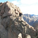
Summit Elevation: 11,918 feet (some sources also list it as 11,912 or 11,916) Trailhead / Route: Trail Canyon / North Loop Trail, Class 1 (Class 3-4 via Devil's Thumb Shortcut) Date Climbed: July 2, 2011 Round-trip Distance: up to 17 miles, slightly less via Devil's Thumb Shortcut Total Elevation Gain: 4,500 to 5,000 feet, maybe more, as there are countless ups and downs along the North Loop Trail (I counted more than a dozen significant dips over a couple miles of the North Loop Trail) Climb Time: 5 hours up to 11,300, 3 hours down Mountain Info: Charleston is the highest mountain in southern Nevada and the 8th-most-prominent mountain in the Lower 48 I should've heeded RenoBob's advice. When I told him about our plans to climb Humphreys, Charleston and Wheeler, he suggested we skip Charleston and spend more time in Great Basin National Park. But for some reason we were stuck on the idea of doing Charleston. Probably because we hear about it every time we go to Las Vegas. And once Jen found out it had a scrambling section (Devil's Thumb Shortcut, or DTS), it was officially on our list. After climbing Humphreys Peak in Arizona, we headed back to Las Vegas to suck down some beers and crash early. Knowing that Charleston would be a long and grueling climb, we left Henderson, a suburb of Las Vegas, the following morning at 3:45 a.m. According to a couple climbing websites I found, which I won't name, the route conditions were described as "doable" and "free of snow." From Henderson I could see some small patches of snow on Charleston, but I trusted the online beta and assumed the snow wouldn't be an issue (or require technical gear). Thus, in an effort to cut down the weight we had to carry on this long slog, we left our ice axes and trekking poles behind. Charleston's upper reaches viewed from Henderson:  At 5 a.m. we started up the trail, sluggish and tired. As we hiked, we determined that the broad peak faraway behind us was actually Charleston. I could tell it was going to be a long day.  After hiking AWAY from the mountain for miles, the trail eventually makes a slow U-turn and begins to head south, toward the summit. But now the mountain was as distant as ever. The scenery was strange and beautiful, and difficult to capture with a camera.     Much of the slightly sloped, single-track trail consisted of loose dirt and marble-sized scree that barely clung to the mountain at the angle of repose. Even though it's just a Class 1 trail, it truly demands your attention because it traverses steep scree slopes that spill over sheer cliffs. For miles and miles and miles. There are literally hundreds of places along the North Loop Trail where a slight misstep, an errant gust of wind or a bout of vertigo could prove fatal. It's not technically challenging, but without a doubt, it's the spookiest and most dangerous Class 1 trail I have ever been on.   And because you put a lot of energy into ensuring you stay balanced and upright, it's surprisingly more difficult - physically and mentally - than your average Class 1 trail. Not to mention, you hike a little slower, which is something else to factor in when doing this hike. Rainbow and Old Town villages far down in the valley below:  As we continued to hike along cliffs and steep slopes, the summit never seemed to get any closer.  According to one sign we read, violent geological activity created this twisted mass of rock 50 million years ago:  A closer look at the DTS, from faraway:  Evil flora:  A cliffy section of trail:  Bristlecone Pines, some of the oldest living things on Earth:  This is about where the trail became a little sketchier, and the summit was still very faraway:  Tripping on a trekking pole in this section wouldn't be a good idea:  Looking over the edge:  Our intention was to go up the Class 3-4 Devil's Thumb Shortcut (DTS) route and then go down the North Loop Trail, because we didn't want to have to downclimb the DTS. But as we neared the upper portion of the mountain, we could see large snowfields, which might have been too dangerous to cross without axes. And if that were the case, we could find ourselves in a pickle, high on the mountain. I brought 30 feet of webbing, just in case we needed to hand-rap down something, but after looking up at the DTS, I think we would've needed at least 40 feet (or I suppose we could've tied a single strand and left it behind). From its base, the DTS looked doable, but it was much steeper than I expected. If it was a route in Colorado, I'm pretty sure it would be considered Class 4. Looking almost straight up from the base of the DTS; a sun-baked rope has been left behind:  In the interest of leaving ourselves an escape route, we decided to scrap the scramble and continue up the North Loop Trail.  This was about the time we encountered our first snowdrift across the trail. It wasn't large by any measure, but it was softening under the sun, and slipping down it wasn't really an option. Just to be safe, I used a flat rock to self belay while crossing the snow.  When we got to a slightly larger and steeper snowfield, I was ready to throw in the towel. I couldn't believe how snow could survive this late into the season and in such a brutally hot climate.  A fall here probably wouldn't have been fatal, but any injury this far from a trailhead would have created a dire situation. The snow wasn't great, either, and it was slushing up under the hot sun. But after evaluating it for a few moments, we decided to continue on up the mountain. Soon thereafter, at about 11,300', we came to an even larger snowfield, with a steep and dangerous runout. We decided we had had enough.  I'm sure we could have made it. The physical or technical challenges weren't beyond us, even without our axes. It was just that the risk finally exceeded the reward. Plus the snow was softening up so much, I'm not sure if axes would have arrested a fall anyway. To add, the heat was intensifying (70 degrees at 11,300' at just 10 a.m., and 88 degrees at the trailhead when we finished), we were drinking down all our water, and the hike was taking much longer than we planned. Just as I always do, I gave Jen a kiss at our "summit." And after soaking in the views for a moment longer, we started back down the mountain.    Unlike some other mountains we've had to turn back on, I didn't feel upset about this one. It did offer some great views, but overall I wouldn't consider it a fun mountain to climb. Regardless, we got in some good training, as we hiked almost 15 miles and gained almost 4,000 feet. And it was probably a good thing we didn't do the whole climb because we had a long drive to make across the desert. Right after climbing Charleston, our plan was to drive directly to Great Basin National Park, and then climb Wheeler Peak and Jeff Davis Peak the following morning. Unfortunately, plans don't always come together. Halfway between Las Vegas and Great Basin National Park, our rental car (Toyota Camry) started sputtering and losing power. It was 109 degrees and the nearest town (i.e., nearest gas station, building, home, anything) was about 35 miles away. When it started sputtering at 80 miles per hour, I threw it in neutral and revved the engine, but it was a feckless attempt at keeping it from dying. As I steered it onto the shoulder, black crows immediately began to gather. This is about where we were (photo taken the following day):  After letting it rest for a few moments, I started it up and it seemed to run OK. So we pushed on, though we decided it was best to turn off the air conditioning. With the windows rolled down, it felt like 20 hair dryers were blowing in our faces. The car limped along for some more miles until we hit a hill. Which is when it lurched and lugged, and then it died again. With our flashers blazing, I was somehow able to get it up that hill in first gear. And once we made it over the pass, I put it in neutral and we basically coasted all the way down to the aptly named town of Caliente. As we rolled into the only gas station in town, we realized we were two and a half hours away from Las Vegas and two hours away from our destination. It was late in the afternoon and there were no vacancies at the cockroach motel next door. "I don't see a town called Caliente on my map," the guy from Hertz's emergency number told me over the phone. "How do you spell it?" Across the street from the gas station, Caliente, NV:  "It's Caliente, like the Spanish word for hot. And it's hot here," I said. "Though it's cooled down to 102 now. But I'm still concerned because we have nowhere to stay because all the motel rooms are booked up for Fourth of July weekend."  We had a few more conversations like that over the course of a half hour. And after doing some research, he decided to order us a double tow, as he called it. "We'll tow a new car to you from Las Vegas and then tow your car back," he said. "But it'll take about three to four hours." It took five. Back on the road in our pimped-out Impala, with leather seats, navigation, dual-climate control, satellite radio and a throaty engine that actually worked, we realized our Great Basin adventure was still a possibility. But we had to make it through the dark desert first. As I learned, because it gets so hot during the day, most desert animals come out at night. In the first 30 minutes of driving, I think I ran over at least three mice and one rabbit. I felt bad, but I was driving 20 miles per hour under the speed limit and I was intently focused on the road, so there wasn't much else I could do. Just when I got into a good, animal-dodging groove, we came across a car with its flashers on and a family in the road frantically waving me down. They had just hit an elk and their car was a little smashed up. Luckily, no one was hurt. The elk, on the other hand, was still twitching in the middle of the road. I pulled off to the shoulder and aimed my headlights toward the oncoming lane so that I could flash my headlights at cars before they careened into the elk. The father, who was driving, was a little freaked out, and he thanked us graciously for stopping. Their cell phone didn't work so Jen called 911. Because we had a GPS, we told the 911 operator exactly where we were, which was 30 miles south of the Hwy 93 and Hwy 50 junction. But the operator said he didn't know where that was and that he had to look it up, so he put Jen on hold. Less than a minute later, her phone lost cell reception. After sitting there for about 20 minutes, another car finally approached. I flashed my lights and an old couple in a van pulled over and got out. The guy that hit the elk told them what had happened, and to our surprise, the old lady said in a calm voice, "Oh, the first time is always scary." Meanwhile, the old man walked over to the now-dead elk and dragged it off the road, as if it were an everyday occurrence. Then, in keeping with their seemingly normal routine, the old lady pulled out some hand sanitizer for her husband. Drive-by shot of the elk the following day, with rigor mortis in full swing:  I asked the guy if he wanted me to drive him and his family anywhere, but he said he'd wait for the police. So after bidding him good luck, we were back on the road. At almost 2 a.m., completely exhausted, we rolled into the Border Inn Hotel parking lot, which is adjacent to the Nevada-Utah border. We may not have been determined enough to get up Charleston. But, damn it, we were going to get up Wheeler. Thumbnails for uploaded photos (click to open slideshow): ")
")
")
")
")
")
")
")
")
")
")
")
")
")
")
")
")
")
")
")
")
")
")
")
")
")
")
")
")
")
|
| Comments or Questions | |||||||||||||||
|---|---|---|---|---|---|---|---|---|---|---|---|---|---|---|---|
|
Caution: The information contained in this report may not be accurate and should not be the only resource used in preparation for your climb. Failure to have the necessary experience, physical conditioning, supplies or equipment can result in injury or death. 14ers.com and the author(s) of this report provide no warranties, either express or implied, that the information provided is accurate or reliable. By using the information provided, you agree to indemnify and hold harmless 14ers.com and the report author(s) with respect to any claims and demands against them, including any attorney fees and expenses. Please read the 14ers.com Safety and Disclaimer pages for more information.