Download Agreement, Release, and Acknowledgement of Risk:
You (the person requesting this file download) fully understand mountain climbing ("Activity") involves risks and dangers of serious bodily injury, including permanent disability, paralysis, and death ("Risks") and you fully accept and assume all such risks and all responsibility for losses, costs, and damages you incur as a result of your participation in this Activity.
You acknowledge that information in the file you have chosen to download may not be accurate and may contain errors. You agree to assume all risks when using this information and agree to release and discharge 14ers.com, 14ers Inc. and the author(s) of such information (collectively, the "Released Parties").
You hereby discharge the Released Parties from all damages, actions, claims and liabilities of any nature, specifically including, but not limited to, damages, actions, claims and liabilities arising from or related to the negligence of the Released Parties. You further agree to indemnify, hold harmless and defend 14ers.com, 14ers Inc. and each of the other Released Parties from and against any loss, damage, liability and expense, including costs and attorney fees, incurred by 14ers.com, 14ers Inc. or any of the other Released Parties as a result of you using information provided on the 14ers.com or 14ers Inc. websites.
You have read this agreement, fully understand its terms and intend it to be a complete and unconditional release of all liability to the greatest extent allowed by law and agree that if any portion of this agreement is held to be invalid the balance, notwithstanding, shall continue in full force and effect.
By clicking "OK" you agree to these terms. If you DO NOT agree, click "Cancel"...
Columbia from the summit of Yale
The day before, we drove towards the trailhead to see if the Ford Fusion could get us close enough to make the climb feasible. Driving slowly, we got to within a quarter mile so all systems were go for the Fourth of July ascent of Columbia from the Three Elk Creek Trailhead.
On the Fourth, I drove the Fusion all the way to the trailhead at 9479 feet (N38 54.045 W106 13.411) at 6:00 a.m. The road was not overly steep and the five inch clearance was enough on the dry road. We headed south to an early crossing of Three Elk Creek. After an hour or so of hiking on a good trail through a scenic forest along the creekThree Elk Creek Trail, we crossed the Colorado Trail at 38 54.019 106 15.709 Race across between traffic on the freewayand continued up the Three Elk Trail along the creek. It was a cool pleasant jaunt with three crossings on log bridges.Hiking trail along Three Elk CreekSecond Crossing
Near 11000' we get our first glimpses of Columbia ahead.Early view of ColumbiaOpen meadows near timberline Near timberline at 11300, we are faced with a crossing of Three Elk without a bridge.Attempted crossing Swollen with snowmelt from the heavy spring snows, we look downstream for a crossing. We try to build a stepping stone bridge, but the heaviest rocks we can find are not big enough to stay put in the swift knee deep current. After wasting about an hour in this otherwise beautiful area, we give in and wade the cold water. So much for writing a route guide for this route.
Once, we are across Three Elk for the last time, we have thick willows to bushwhack but we reach open meadows and a beautiful view of Columbia at the head of the basin Columbia at head of basin. Our data shows we should gain the top of the east ridge around 12500 to 12800 and we look for any sign of a trail up to the ridge top. We waste more time and finally conclude to wing it up the steep slopes.
The trick is to get onto the ridge crest as low as reasonable so we cut a path between the willows and downed timber from old avalanche paths. Four hours in, we take a break at 38 54.191 106 16.106 at 11820. This is at a gap between the willows and the downed timber and is a key point on the ascent.Passage between willows and downed timberSoutheast RidgeAscent route From here, we switchback up the slopes, making an occasional 2+ move but no real scrambling. Although it is steep, there is no loose scree on this route.Steep slopes but no scree
Once on the ridge, there are great views down into the Frenchman Creek drainage as well as views across to the Southeast Ridge. View down route from East RidgePoint 13373 on ridge east of HarvardThere are three false summits along the way with as much as 120 foot descents to the low points between the humps.One of three false summitsEnjoyable stroll above 13000Ridge continuing toward real summitNearing summit with a small snow fieldLooking back on false summit...Over or around?Southeast Ridge and Princeton from near 13800
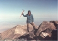
Altogether it took us slow hikers from the plains of Kansas until 3:00 p.m. to summit. Summit photo with Harvard in background The weather co-operated or we would have never made itCompanion nearing summitMount HarvardLooking down on routeBear Lake and more snow on Traditional RouteLooking over Divide to Taylor Park ReservoirBuffalo Peaks to the EastFrenchman Creek--pumped water from snowfield melt trickle We had to hurry to reach the trail before darkheading down. We attempted to cross Three Elk Crerk at a higher point but had nasty willow bashing after we crossed so it is probably better to cross around 11300 instead of above 11400. We also learned how much slower it goes after dark with inadequate lighting.
Worst of all, we could not find the trailhead parking. We were navigating to a GPS waypoint called Columbia Car. We spent almost two hours bungling in the jungle and could get no closer to it than .28 miles. At about 2:00 a.m., we are all but resigned to spending the night in the woods (at least it wasn't cold or rainy) when we see a van and then a car from Kansas. It turns out it is my Fusion. We were trying to navigate to where I had parked the previous day. At midnight, we were within 300 feet of the car. Two hours and a lot of frustration later, we found the car.
Lessons learned: Don't waste time building crossings and make sure you are navigating to the correct point. Environmentally, this is a great route. Perhaps it needs a cairn or two, but it was more adventuresome like this.
Thumbnails for uploaded photos (click to open slideshow):
Great Trip Report with Awesome Photos! 8/27/2011 2:57am
Some awesome photos of this fun climb. Columbia's Northeast Ridge is a ”hidden gem” that is far superior to the standard route. Thanks for sharing your adventure! Climb on...
The conditions have changed significantly since my unsuccessful summit attempt on this route over Memorial Day weekend. Going to give it another shot over Labor Day weekend. We Kansans are a determined bunch! Way to hang in there and overcome the adversities of the day, even the self-created ones.
Caution: The information contained in this report may not be accurate and should not be the only resource used in preparation for your climb. Failure to have the necessary experience, physical conditioning, supplies or equipment can result in injury or death. 14ers.com and the author(s) of this report provide no warranties, either express or implied, that the information provided is accurate or reliable. By using the information provided, you agree to indemnify and hold harmless 14ers.com and the report author(s) with respect to any claims and demands against them, including any attorney fees and expenses. Please read the 14ers.com Safety and Disclaimer pages for more information.
Please respect private property: 14ers.com supports the rights of private landowners to determine how and by whom their land will be used. In Colorado, it is your responsibility to determine if land is private and to obtain the appropriate permission before entering the property.


 Columbia from the summit of Yale")
 Hiking trail along Three Elk Creek")
 Early view of Columbia")
 Columbia at head of basin")
 Passage between willows and downed timber")
 Steep slopes but no scree")
 View down route from East Ridge")
 One of three false summits")
 Nearing summit with a small snow field")
 Summit photo with Harvard in background")
 Three Elk Creek Trail")
 Race across between traffic on the freeway")
 Second Crossing")
 Open meadows near timberline")
 Ascent route")
 Point 13373 on ridge east of Harvard")
 Enjoyable stroll above 13000")
 Ridge continuing toward real summit")
 Looking back on false summit...Over or around?")
 Southeast Ridge and Princeton from near 13800")
 Companion nearing summit")
 Mount Harvard")
 Looking down on route")
 Bear Lake and more snow on Traditional Route")
 Looking over Divide to Taylor Park Reservoir")
 Buffalo Peaks to the East")
 Frenchman Creek--pumped water from snowfield melt trickle")
 heading down")
 Southeast Ridge")
 Attempted crossing")