Download Agreement, Release, and Acknowledgement of Risk:
You (the person requesting this file download) fully understand mountain climbing ("Activity") involves risks and dangers of serious bodily injury, including permanent disability, paralysis, and death ("Risks") and you fully accept and assume all such risks and all responsibility for losses, costs, and damages you incur as a result of your participation in this Activity.
You acknowledge that information in the file you have chosen to download may not be accurate and may contain errors. You agree to assume all risks when using this information and agree to release and discharge 14ers.com, 14ers Inc. and the author(s) of such information (collectively, the "Released Parties").
You hereby discharge the Released Parties from all damages, actions, claims and liabilities of any nature, specifically including, but not limited to, damages, actions, claims and liabilities arising from or related to the negligence of the Released Parties. You further agree to indemnify, hold harmless and defend 14ers.com, 14ers Inc. and each of the other Released Parties from and against any loss, damage, liability and expense, including costs and attorney fees, incurred by 14ers.com, 14ers Inc. or any of the other Released Parties as a result of you using information provided on the 14ers.com or 14ers Inc. websites.
You have read this agreement, fully understand its terms and intend it to be a complete and unconditional release of all liability to the greatest extent allowed by law and agree that if any portion of this agreement is held to be invalid the balance, notwithstanding, shall continue in full force and effect.
By clicking "OK" you agree to these terms. If you DO NOT agree, click "Cancel"...
Putting The "Wild" in Holy Cross Wilderness: 12ers of The Lime Creek Cirque
Stats and Such Peaks Climbed (in order) Avalanche Peak (12,803') 780th Highest PT 12860 C (12,860') Soft Ranked PT 12980 (12,980') 649th Highest "Hammer Peak" (12,973') 654th Highest PT 12977 (12,977') 652nd Highest Trailhead
Woods Lake/Eagle Lake (dirt, 2WD accessible) Mileage and elevation gain
16.5 miles and 6400' vertical gain based on GPS stats Resources
Trails Illustrated #126 Holy Cross/ Ruedi Reservoir
Lists of John (links above)
My own recon photos from neighboring Fools Peak, Charles BM, Burnt Mtn and PT 11087
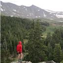
Avalanche Peak from the Trailhead (taken on way out)
Why?
Some of you who know me, know that I am working on climbing every peak in Eagle County and also every peak in Holy Cross Wilderness, and let's face it, sometimes 12ers can be pretty cool... even in the Sawatch. Oh let's get that straight from the beginning. This is a trip report about rarely climbed 12ers in the Sawatch, most of which don't even have official names. Seeing as the Sawatch are just a bunch of boring talus piles, I won't be offended if you click the "back" button on your browser and go look for something else to read. Its okay, you won't hurt my feelings. But before you do, just keep in mind that this is not your typical Sawatch...
Still here? Good! Now, close your eyes, and while you do so try and erase all those awful memories of Columbia's West Slopes, or the 50 people you were tripping over on Elbert's summit. Pretend you never even heard of the Sawatch. Your eyelids are a blank canvas. Okay, open your eyes...
Heading Into The Unknown
This was to be a journey into the unknown, an exploration into the remote corners of the southwestern Holy Cross Wilderness, a place I had never been to before. I have been close once or twice, even being on the ridge that makes up the northern side of the basin, but that was from the other side. I have had distant views of these summits from all over the place, including the summit of Mt of The Holy Cross itself. Aside from those distant views, all I had was a map and a vague sense that the connecting ridge must go, because according to the ascent detail on Lists of John, someone else had done it before. I guess I could have tried to get in contact with that person, but I decided the fun is in the adventure, that heading into the unknown was what was going to make this trip special.
I drove from my house down the familiar roads south of Eagle and over Crooked Creek Pass, then followed the road to Woods Lake and parked at the end of the public road at a small trailhead parking area. From here there are two trails, the Eagle Lake trail being the one I wanted. It skirts the private land by going up and around Woods Lake through overgrown plants that were covered in dew and gave a wet start to my day. At the backside of the lake, the trail briefly joins a road to small power station on the creek, then heads off into the woods as it climbs towards Eagle Lake. Near the Wilderness Boundary I left the trail and the bushwhacking began through lush vegetation towards the northwest ridge of Avalanche Peak.
Eagle Lake from Ridge Above
There was one really steep section for a couple of hundred feet that even involved some scrambling over rocks and a few tree belays. Not sure if that type of terrain is avoidable or not with a better line, the contours on the topo are all about the same in that area - really tight. The terrain eases at the ridge, but is still in the trees for a little while. Above treeline it was a mix of talus and grass slopes before becoming mostly talus higher up. The ascent of the ridge was basically class 2 and was easy to follow.
Upper Route on Avalanche (taken from TH)
Along the way the views start to open up, especially towards the Elks. You also get a really great view of "Ribbed Peak", one of the least climbed 13ers in the state according to the summit logs on List of John, I still need to get up this one myself.
The Lime Creek Cirque is glaciated and, similar to Rocky Mountain National Park, is gentle on one side, and nearly vertical on the other. In this case, the left side is always a huge drop off into rugged basins with cool little tarns, while the right is more gentle.
One of many cool tarns below the cirque
Eventually I knew I was going to have to find a way back into the basin, but for now the ridge was my main concern. Avalanche was just a warm up, and the route stayed at class 2 until over the soft ranked PT 12860 that I passed along the way.
Looking back at the descent off Avalanche
The heart of the cirque is the trio of peaks near its head, PT 12980, PT 12973 (called "Hammer Peak") and PT 12977. As I traversed this airy ridge I wondered why the other two peaks were not called "Anvil" and "Stirrup", because the vertigo inducing drops to the left really play with your inner ear. The peaks are clustered together tightly, only about 3/4 of a mile separate the first from the third. And the variation in elevation between all three summits is only 7 feet.
The first peak is the highest, PT 12980. It is also possibly the most complicated of the bunch. Coming from Avalanche is a rough ridge with plenty of class 3 scrambling to reach the summit area. In the spirit of adventure, I will only show images of the overall ridge, no route lines and no close ups (except at the summit block, but we'll get to that). If anyone chooses to climb these peaks I am sure this information will be helpful, but will still give them the chance to find their own way and discover the route as they go. After all, that is part of the fun, right?
The route to PT 12980
Once at the summit area there is a large notch and two seemingly identical summits. The first candidate for highpoint is easy to get to, its on the same side of the notch as you are and also right in the path of the traverse to the next peak. After trying to level the summit with my nalgene, I was convinced, however, that the one on the other side of the notch was a foot or two taller and began figuring out how I was going to get there. The notch is deeply set with exposed drops on either side, but you can climb directly into it from the first summit. I thought it was all class 3, but I am also 6'-1", a shorter person may struggle more. The upclimb on the other side was over a large block that downslopes slightly. These tricky moves were a little scary with the air below, but the rock quality was good. It was a cool little summit with lots of pyrite (or some other shiny stuff) speckling the rocks that glistened in the sun. This summit should be the Stirrup, because of the shape of the notch and the two summits is almost like an inverted stirrup minus the foot support.
The notch, true summit on left
Looking back at notch from descent (true summit on right)
It was now time to continue on to "Hammer Peak", first having to negotiate two towers on the downclimb. From a distance they looked formidable, especially the first. I thought I would need to bypass them, but up close the ledges were wide, the holds good, and taking them head-on is certainly the right call. There really didn't look like there was a viable bypass anyway!
Towers on PT 12980 descent
The terrain eased a bit, and the route to "Hammer" from the saddle was actually surprisingly gentle. There was still a lot of work to do though before I would be back in the valley, and this part of the cirque has the most exposure to the left that I had come across yet. I kept looking for "just in case" bailouts and they are few and far between, and not very attractive options (but might be good snowclimbs in spring!). You need good weather here because there really isn't much on the left. Luckily you can bail right, but its a lot longer hike to Woods Lake that way if you did.
Gentle slopes to Hammer
The downclimb of "Hammer" was immediately back into scramble mode, a stiff class 3 chimney provided the first drop, and again my height was advantageous. People should come into this climb expecting it to be class 4. The steep ridge was enjoyable though, and once again it appeared the climb of the other side was going to be relatively gentle.
Steep chimneys on Hammer Descent
Hammer descent overview
It certainly started out that way, but then there is some difficulty as you get close to the top. I started on the ridge crest but then the inner ear vertigo kicked in when I looked into a sheer notch and had to retreat and pass below. Looking back up at the notch from below confirmed that decision!
The route to PT 12977
Yeah, good call on bypassing the notch!
As I rounded a tower and passed between some big rocks I saw that I was back in business and climbed up the broken face of rock and tundra on 3rd class steps to a more gentle finish and a long ridge. This summit would be the Anvil as the long flat section at the top would better resemble one than the other summits would.
Back in business
Hammer and PT 12980 from PT 12977
From here I enjoyed the view of some of the surrounding lakes from above, including Strawberry Lake and some unnamed tarns below the backside of Savage Peak.
Strawberry Lake, really does look like a strawberry!
Unnamed tarn on backside of Savage Peak
The descent to the saddle was going to be interesting, I knew the ridge was going to have some surprises so I started off down the backside and traversed some ledges below the ridge crest to avoid the inevitable. I was glad I did, but the ledges were not trivial either. There were a few ribs to cross that had a scramble move or two, but in general with good route finding this wasn't too bad.
Ledge system to saddle
Finally reaching the saddle it was going to be a steep descent to the valley, but at least I had a clear path. It was steep loose talus, and often when I turned around to look back up I wondered where in the heck I was able to find a route through this maze of talus surrounded by steep slabs and cliff walls. If Rodney Dangerfield climbed this route he would probably say something like "It was rough I tell ya, the Sawatch get no respect".
Descent route from saddle to valley
Back in the valley I could breath a sigh of relief knowing that I had come out the other end of this unknown ridge traverse in tact. It was still a long way out though, and I didn't think there was going to be a trail seeing as the maps show it ending at Eagle Lake several miles below me. To my surprise, however, there was a workable trail most of the way, sure it was overgrown in every meadow I crossed, but I was able to string it together and avoid any nasty bushwhacks on the way out.
Hammer from below
PT 12977 from Strawberry Lake
There and Back Again
I was still in the unknown, sometimes the journey back is just as wonderful, if not more so, than the peaks we climb. I had no idea what I was in for, but figured the terrain would be gentle enough to not need to worry about. For that, I was correct, the terrain along the trail was gentle and the worries were few, but the sights were just beginning. Have you ever seen that office supplies store commercial where the guy goes around saying "WOW! That's a low price!". Well the hike I out I felt a little like him. Eye candy overload. I was sugar high like a kid eating Halloween candy. Everywhere I looked I couldn't help but say "WOW" and then click a picutre. I was blown away by the ruggedness of the cirque and the many small tarns and waterfalls along the trail. You wouldn't believe this could be the same mountain range that brought you the Collegiate Peaks. Someone should petition the USGS to rename the Holy Cross Wilderness as its own range. Its not the Sawatch, it can't be. Or maybe its appropriate that it is the Sawatch because maybe that helps keep the people away. That misconception that its just a bunch of boring lumps preserves the truly special areas for the adventure seeker in us to dig a little deeper.
I leave you with the visuals of the hike out, the pictures tell it better than I could anyway. After all I work as an architect, I am a visual person...
Lime Creek Cirque
Waterfall #1
Waterfall #2
Looking up at Ribbed Peak (one of CO's least climbed 13ers)
Lime Creek tarns and cascades
Looking back from near Eagle Lake
One last waterfall
Thumbnails for uploaded photos (click to open slideshow):
Mike, this is a must-do now for me. I know Kane has talked about these 12ers before and it's been on the back of my mind but this area is stunning. Simply gorgeous, thanks for sharing and also thanks for not being TOO specific on the exact route up and down. Fun.
The Hunter Fryingpan Wilderness, Holy Cross Wilderness, and even the northern sections of the Collegiate Peaks Wilderness hold some hidden gems. Thanks for posting
And within a few hours, 201 people have read this obscure 12er trip report. Imagine that!
I had no idea this area was so pretty. Thanks for the visuals.
I really want to make a joke about Ribbed Peak being a pleasure, but I can't come up with one.
Floyd - I know, my lists keep growing too! Maybe if I ever finish some of them it will feel like progress?
SuperPolok - I emailed Kane a link, you guys definitely need to check this area out!
mennoguy - Nice to see another northern Sawatch fan, lots of nice areas if you know where to look!
Matt - I wonder how many hit ”back” when they realized it wasn't a TR about Holy Cross, ha!
MtnHub - No problem, a truly wild and beautiful place indeed!
Nice report Mike! I'm glad you posted this one. So thanks for sharing your adventure while not giving away the details. Maybe someday I'll go in there.
The peaks look cool from afar, as you said.
Being on them I'm sure is even better!
Thanks for that link. I think you're crazy for posting these hidden gems. Boy, they sure look a lot like the Gores! That means loads of class 3 and for scrambling!
I just got done reading Aubrey's Cascades report and then looked at this and noticed a few minor similarities. Looks like quite a place, thanks for sharing Mike.
Thanks guys, I think 90% of the people who would climb these peaks (who haven't already) have probably responded with posts here, so I am not too worried about giving away any secrets on these. It will be a while before random remote 12ers are ”en vogue”.
is by seeing how much it makes me salivate and want to get to the mountains as soon as possible from the university library in Akron, Ohio. This one REALLY made me salivate! Great trip report and i am definitely adding this one to my to-do list.
Hey i just wanted to ask if you saw any fish surfaces in the upper lakes down in the valley. like strawberry lake and down. Was also wondering if you knew anything about pearl lake that is at the base of Avalanche peak? Thanks for any possible info trying to hike in and fish these lakes.
Caution: The information contained in this report may not be accurate and should not be the only resource used in preparation for your climb. Failure to have the necessary experience, physical conditioning, supplies or equipment can result in injury or death. 14ers.com and the author(s) of this report provide no warranties, either express or implied, that the information provided is accurate or reliable. By using the information provided, you agree to indemnify and hold harmless 14ers.com and the report author(s) with respect to any claims and demands against them, including any attorney fees and expenses. Please read the 14ers.com Safety and Disclaimer pages for more information.
Please respect private property: 14ers.com supports the rights of private landowners to determine how and by whom their land will be used. In Colorado, it is your responsibility to determine if land is private and to obtain the appropriate permission before entering the property.


")

")


")


")


 Avalanche Peak from the Trailhead (taken on way out)")
 Eagle Lake from Ridge Above")
 Upper Route on Avalanche (taken from TH)")
")
 One of many cool tarns below the cirque")
 Looking back at the descent off Avalanche")
 The route to PT 12980")
 The notch, true summit on left")
 Looking back at notch from descent (true summit on right)")
 Towers on PT 12980 descent")
 Gentle slopes to Hammer")
 Steep chimneys on Hammer Descent")
 Hammer descent overview")
 The route to PT 12977")
 Yeah, good call on bypassing the notch!")
 Back in business")
 Hammer and PT 12980 from PT 12977")
 Strawberry Lake, really does look like a strawberry!")
 Unnamed tarn on backside of Savage Peak")
 Ledge system to saddle")
 Descent route from saddle to valley")
 Hammer from below")
 PT 12977 from Strawberry Lake")
 Lime Creek Cirque")
 Waterfall #1")
 Waterfall #2")
 Looking up at Ribbed Peak (one of CO's least climbed 13ers)")
 Lime Creek tarns and cascades")
 Looking back from near Eagle Lake")
 One last waterfall")