Download Agreement, Release, and Acknowledgement of Risk:
You (the person requesting this file download) fully understand mountain climbing ("Activity") involves risks and dangers of serious bodily injury, including permanent disability, paralysis, and death ("Risks") and you fully accept and assume all such risks and all responsibility for losses, costs, and damages you incur as a result of your participation in this Activity.
You acknowledge that information in the file you have chosen to download may not be accurate and may contain errors. You agree to assume all risks when using this information and agree to release and discharge 14ers.com, 14ers Inc. and the author(s) of such information (collectively, the "Released Parties").
You hereby discharge the Released Parties from all damages, actions, claims and liabilities of any nature, specifically including, but not limited to, damages, actions, claims and liabilities arising from or related to the negligence of the Released Parties. You further agree to indemnify, hold harmless and defend 14ers.com, 14ers Inc. and each of the other Released Parties from and against any loss, damage, liability and expense, including costs and attorney fees, incurred by 14ers.com, 14ers Inc. or any of the other Released Parties as a result of you using information provided on the 14ers.com or 14ers Inc. websites.
You have read this agreement, fully understand its terms and intend it to be a complete and unconditional release of all liability to the greatest extent allowed by law and agree that if any portion of this agreement is held to be invalid the balance, notwithstanding, shall continue in full force and effect.
By clicking "OK" you agree to these terms. If you DO NOT agree, click "Cancel"...
First off we're from Tennessee and we have tried winter 14er ascents the past two years and were hoping to finally succeed by choosing a mountain we knew and one that is supposed to fairly safe. We started at 1:00 pm on Thursday Feb 16th just short of the 3rd cattle guard off CR250. Start at CR 250 We hiked the 3.5 miles to the Blank's Cabin TH. From there we started up the standard route. Blanks Cabin TH We followed the snow buried trail for a few hundred feet of elevation gain but eventually there was no trail because micro bursts of 110 mph wind flattened entire sections of forest back in November and December. There were giant trees stacked on top of each other covered in several feet of snow blocking the standard route. No one knew the extent of the damage from the wind storms until we were in the thick of the disaster zone. It would take 5 minutes or so to go over a few trees making that route impassible. We had to make our own route bushwhacking up the mountain on steep slopes (30-35 degree) in minimum knee deep snow with snow shoes. We made it to a ridge at 11,000 that would take us to the summit. We thought we were home free and would be skirting up a ridge in a couple feet of snow but oh how we were wrong. The ridge ended up having even worse wind damage making it impossible to stay on it. At this point it was dark and we didn't want to get disoriented so we camped at 11,000 ft. Downed trees at night.Downed trees in the morning. The temperature dropped to -15 F as confirmed by a thermometer. The next morning we got moving at light and came off the ridge, picking our way around the damaged areas and working our way up to 11,400 ft. At 11,400 From there we proceeded up a slope of over 45 degrees to 12,400 ft. Looking down at SamSam It took 1.5 hr of full exertion to gain these last 1000 ft. Although we were at tree line, and only about 0.25 mi away from the route above tree line, the snowy conditions were too much. Sam Drifts up to 10 feet deep were the limiting factor. Each step typically only gained 3-6 inches. Even though there is apparently less snow this season it was not evident on Shavano. It took careful navigation to avoid the dangerous heavy loaded wind slabs which was quite unexpected for this part of the mountain. It would have taken minimum 1 hour to traverse left to the trail but it was already 12:30 pm. Once on the trail and out of the trees it likely would have taken 3 hours to get up and back to that same point. Down the slope After one night on the mountain we weren't prepared to spend another. We did good to stay hydrated but the altitude, cold, and exertion kept us from keeping up our colorie intake. After over 15 hours of hiking/climbing we were only able to consume around 300 calories. If we had tried for the summit likely we wouldn't have made it back to the car until after mid night or we'd have to stay the night on the mountain and both of these options seemed unnecessarily dangerous. We made it back to the car by 5:30 pm just as the sun set. Shavano demoralized us, but oh well, it was a good learning experience and we'll try again next year. Me
Thumbnails for uploaded photos (click to open slideshow):
Keeping food close to the body helps keep it edible (unfrozen). Maybe you should try some gu gels or honey stinger packets. Those are 120 calories a piece (about) and all you really need is one every couple of hours. I also keep snickers handy, cheese and summer sausage also take longer to freeze. These compared with triscuts make for a good snack.
Did you guys carry your camping gear with you? I was also curious as to wether or not you carried a slope angle meter? Those slope angles you were on sound like prime conditions for an avy. Glad you all fared well and stayed safe.
We selected food that would not freeze solid as we're pretty experienced in cold weather out here in the appalachians where it can easily drop below 0 in the winter. We just couldn't stomach much of it and that was the calorie problem. Each bite was worrisome. I guess we figured having low energy was better than puking on the mountain. We brought camping gear (tent, -20F sleeping bag, and pads) although we didn't have a stove and had only packed in around 4-5 liters. We waited too long to stash the gear because we kept hoping to hit the main route.
We did not have a slope angle meter but I made rough estimates using the trekking pole method and based on previous experiences. The tree disaster was why we kept ending up on steep slopes it just seemed that everywhere we turned there were more of those stupid trees piled up in our way. I have done Mt. Shavano in the summer but I can't emphasize enough how those stinking trees made our experience beyond miserable. It was really discouraging.
Do you have any pics of 10 foot drifts? It seems from your photos that there is very little snow there. Which, makes sense why you had lots of down trees to contend with. Usually there is enough snow to bury them.
Secondly, I highly doubt you were on ”over 45 degree” terrain. That is very steep, and I don't think any part of Mt. Shavano is that steep.
@GIR: I didn't take any pictures of the deep drifts or the steepest slopes because to be honest I was completely miserable and not in the best of moods. The trees you can see above the snow were piled on top of more trees that were buried in the snow which was why crossing the trees was so difficult. Around the trees it was typically knee to thigh deep. The deepest drifts were above 12,000 ft which I thought was quite strange. There were only a handful of the extremely deep drifts but they were killer on our progress. Literally moving 3 inches at a time through these stinking drifts digging with my trekking poles a trench through them. Ahh I see where I typed ”over 45 degrees” and that is definitely NOT true and is a typo. The slopes that were 40-45 (at most) persisted for no more than 30-45 ft but stayed pretty consistent around 30-35 degrees most of our path above 11,200. It was much steeper than the traditional route because we weren't on it. If you're familiar with the mountain we ended up a north of where we should have been.
@Jameseroni: Haha yeah. We're expecting it and we take every precaution possible short of a prescription but it still gets us pretty bad considering Nashville is at 500ft. But if we want to try and get experience in the winter we have to pay the price.
Caution: The information contained in this report may not be accurate and should not be the only resource used in preparation for your climb. Failure to have the necessary experience, physical conditioning, supplies or equipment can result in injury or death. 14ers.com and the author(s) of this report provide no warranties, either express or implied, that the information provided is accurate or reliable. By using the information provided, you agree to indemnify and hold harmless 14ers.com and the report author(s) with respect to any claims and demands against them, including any attorney fees and expenses. Please read the 14ers.com Safety and Disclaimer pages for more information.
Please respect private property: 14ers.com supports the rights of private landowners to determine how and by whom their land will be used. In Colorado, it is your responsibility to determine if land is private and to obtain the appropriate permission before entering the property.


 Start at CR 250")
 Blanks Cabin TH")
 Downed trees at night.")
 Downed trees in the morning.")
 At 11,400")
 Looking down at Sam")
 Sam")
 Sam")
 Down the slope")
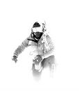
 Me")