Download Agreement, Release, and Acknowledgement of Risk:
You (the person requesting this file download) fully understand mountain climbing ("Activity") involves risks and dangers of serious bodily injury, including permanent disability, paralysis, and death ("Risks") and you fully accept and assume all such risks and all responsibility for losses, costs, and damages you incur as a result of your participation in this Activity.
You acknowledge that information in the file you have chosen to download may not be accurate and may contain errors. You agree to assume all risks when using this information and agree to release and discharge 14ers.com, 14ers Inc. and the author(s) of such information (collectively, the "Released Parties").
You hereby discharge the Released Parties from all damages, actions, claims and liabilities of any nature, specifically including, but not limited to, damages, actions, claims and liabilities arising from or related to the negligence of the Released Parties. You further agree to indemnify, hold harmless and defend 14ers.com, 14ers Inc. and each of the other Released Parties from and against any loss, damage, liability and expense, including costs and attorney fees, incurred by 14ers.com, 14ers Inc. or any of the other Released Parties as a result of you using information provided on the 14ers.com or 14ers Inc. websites.
You have read this agreement, fully understand its terms and intend it to be a complete and unconditional release of all liability to the greatest extent allowed by law and agree that if any portion of this agreement is held to be invalid the balance, notwithstanding, shall continue in full force and effect.
By clicking "OK" you agree to these terms. If you DO NOT agree, click "Cancel"...
73rd highest peak in Colorado
Climb Date: 25 February, 2012
Crew: sgladbach (Steve), globreal (Britt), Rainier_Wolfcastle (Shawn), CarpeDM (Dave) "Okie" (Dave's beagle).
Mileage: 13 miles give or take.
Vertical Feet Climbed: 6,300 approximate (according to Dave's GPS and map readings).
Trailhead: Midwest Mine off of CR 503 in Mineral Country
Directions to TH: From Creede, Colorado take the CR 504 (Bachelor Mine Rd.). This is the same road you take as if you are going to The Equity Mine on your way to San Luis Pass or the west route to San Luis Peak. At the "T" intersection of CR 504 & CR 503, turn right and take CR 503 (West Willow Creek Rd.) to the hairpin turn at the Midwest Mine. Park here. (There are buildings and a sign for the mine.)
Note: see maps & Dave's GPS track at the end of this TR.
________________________________________________________________________________________________________________________________________
14ers.com member Steve Gladbach had posted a "Winter Gathering" to be held the weekend of Feb. 25-26 in the northern Sawatch Range. The camping area was to be the North Halfmoon trailhead and the peaks would be the Massives, Oklahoma or Deer Mnt. However, the avalanche danger was unusually high this winter. Six avalanche deaths had already occured in the Colorado mountains. The word (and warning) going around was that this is the highest avalanche danger the state has experienced in the past 30 years! So, with the precarious snowpack and recent snows everyday the week prior to the gathering, Steve cancelled it.
I was disappointed. Due to a bad cold and a ankle injury, I hadn't been able to climb since the middle of December and I was really looking forward to the Winter Gathering. Now what?
Having lived in Phoenix, Arizona for 6 � years, I saw a lot of people escape the winter conditions of the north and in Canada, and head to the warmer climate of the south. Well, I suggested to Steve that we do the same so to speak....and head south to Phoenix. Phoenix Peak that is...in the southern San Juans.
The avalanche conditions were noticeably lower in the southern San Juan mountains. While the northern part of the state was getting snows everyday, the southern San Juans hadn't received any snow for the last seven days. This is what drew us to Phoenix.
Personally, my current goal is climbing the Centennials. Steve's is considering the goal of climbing the Centennials in calendar winter. So, the two of us decided to team up and go for Phoenix Peak in lieu of the Winter Gathering in the Sawatch.
We drove over to Creede Friday afternoon as we were hoping to take a look at the peak before dark. We decided to drive on up to the Midwest Mine, our potential trailhead at 10,200 feet. We wanted to see what the road conditions were going to be like before heading out early the next morning. We got to the TH before sundown and so we got out of the car and into our snowshoes to head out to test the snow. We both thought, "Wow! This is going to be a tough climb tomorrow in all this soft sugar!"
A little snowshoe testing turned in to more of a mini- hike even though we were still in our jeans and cotton t-shirts. We ended up hiking � mile to the 10,600 saddle between Midwest Mine and Phoenix Mine which gave us a nice view across the East Willow Creek drainage. This is exactly what we were hoping for... to actually see what our options would be the next day. However for me, seeing how far away the peak was away really didn't give me any thoughts that we would be successful.
However, from our viewpoint, we did spot a dark swath (burn area) up through the steep west face below the summit which was snowfree. Nice! If we took this avy-free path, it would also give us the shortest route through the deep, snow-catching evergreen trees up top. And then above treeline, we saw exactly what we were hoping for....a route that was windblown with no loaded slopes above!
We opted not to winter camp at the TH and instead headed back down to Creede to stay in a nice warm motel. The Snowshoe Motel is great. The owners are very accommodating, and MJ's Restaurant right across the street is very convenient with good food. I would recommend both. CarpeDM & Rainier_Wolfcastle came in that night and got a room. The next morning we were off at 5am.
We drove to the TH by 5:30am and were snowshoeing by 5:45am. Our goal was to be back up on that ridge by dusk at first light, which we did.
We decided upon this longer and higher route above the valley floor for two reasons. One, we assumed the bottom of the drainage along East Willow Creek would have deeper snow to stomp through and second, we thought we might have a safer avy route up higher along this 11,000 foot ridge.
As it turned out, this route was also deep...and a lot of work! The one thing I started doing early this morning was changing my thinking about our return time. Often, my goal is to make it back to the car by dark. On this day, I knew that wasn't going to happen. So, I started telling myself...."we aren't going to be back to the car until 10pm. And that's okay!" "Yes...that's okay!!"
One of the reasons we didn't take the CR502 road down in the valley which parallels East Willow Creek, is that we ran into the Sheriff the night before at dinner who had told us that that road isn't plowed in winter. And in fact, that they've already had 3-4 avalanches slide across that road! This was really good to know since that route looks so easy and tempting.
Along this higher route, we did get some relief from deep snow on somebare terrain in a few aspen groves. However, sidehilling in snowshoes isn't loads of fun either. Argh!
Not paying attention, we made a mistake by getting lured up into the Whited Creek drainage. This added extra distance and work that was really disappointing. Once we noticed this, I kinda lost hope of the summit...again.
However, rounding the bend of the mountain and seeing Phoenix Park, our bare slope ramp, and Phoenix Peak above, this picked up my spirits again.
Shawn takes in the view of our route and goal above.
It's the details in nature that can be fun to see and notice.
Shawn and Dave make there way across the broad, open expanse known as "Phoenix Park." We had several "whoomphs" and shooting cracks take place in this area.
Steve is an animal! While we rotated out on occasions, Steve broke the majority of the trail for us this day. In fact Shawn asked him, "do you have an iron lung or something?"
After crossing to the north edge of the open clearing (Phoenix Park), it was time to turn easterly and to begin the steep portion of the program. And I must admit, it was a bit daunting to think, we NOW have 3,400 vertical feet to climb! It was at this point that Dave and Oakie decided it best to turn around. So, from here on it was just the three of us....me, Steve, and Shawn.
While the slope was steep, it was a nice relief to walk in the snow-free "burn zone" without snowshoes for a while.
From the top of the burn zone, you can see our route we took in red. The route in blue are some forest service or mining roads which could be alternative routes in lower avy danger as well as the 502 road up East Willow Creek. Again, we stayed high to avoid as much avy danger as possible.
Shawn makes his way up the ridge above the burn zone and before the trees. From here to the windblown talus above was actually pretty steep and really difficult in the soft snow.
After a while, Steve went back to check on Shawn and I took over breaking trail. Tough!!! In spots the snow was crotch deep. In fact, at one point I just couldn't even make progress up the steep slope. It was to deep too step up and all that sugar just prevented any stepping up. I had to dig out the snow to build a shelf to step up on. I had recently read a book called DEEP SURVIVAL by Lawrence Gonzales. He documents those who lived and those who died in survival situations. He truly shows what can happen to those whose mindset is focused on the next small goal and thinking positively verses, those who focus on the negative with a fatalistic attitude. So, I kept repeating a phrase that I've seen in the Bible...."be strong and courageous!" (I know, I know... it sounds cheesy, but it worked!)
Then it helped getting a view between the trees of the summit above.
Steve scouts our route up Phoenix.
To the left/north of Phoenix Peak is a snow loaded gulley and drainage. That would not be the way to go!
Treeline! The hope of a windblown slope ahead gives us a renewed desire to push on through the deep snows.
Looking up at the rounded knoll that is our next obstacle to overcome. We ended up traversing to the southeast a bit and then stashed our snowshoes at 12,000.
Ah, what a joy it is to drop the weight of the snowshoes and hike on talus! Shawn makes his way up.
From the evening before with our saddle view across the East Willow Creek drainage, we couldn't see what we could encounter on the back side of that knoll. I had a couple of evil thoughts... thinking we may encounter some sort of terrain trap or a cliff barrier that would do us in. But no! This couldn't have been more pleasant to put eyes on!
Once on the final 1,500 of climbing, we were finally making the typical climb rate of 1,000 feet/hour. Steve is doing well in spite of being quite drained from all the snow busting he had done.
From reading DHatfield's trip report online, I was ready for the fact that once we "topped out", that we actually had a little bit further to go to get on the true summit. We were not coming up to Point 13780 as Doug and Susan were however, when we reached the ridge top, we still needed to turn left and walk 150 yards along the ridge to the massive summit cairn, "true summit."
I got so excited that we were going to make this summit that I actually started running! There it is, the big, honkin' 6 foot summit cairn!
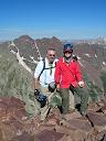
Success! What a great feeling....even though it was late in the day at 4:15pm. It just took us 10 � hours to make this summit in winter. Wowser! But the view back toward Creede makes it all worthwhile.
A moment later, Steve shows up. He told me later on the way down that breaking all that trail through the deep snow did take it's toll on him. I was really starting to think this guys never feels pain or suffers.
Looking south, you see the big cornice line along that east-facing ridge.
And then comes Shawn, feeling a bit victorious as he makes his way to that big summit cairn in the sky!
The view was beautiful looking north to fourteener San Luis (left of center) and Centennial thirteener Stewart Peak (right of center).
My camera "froze up" having had it out in the cold for too long and so we didn't get the traditional group/summit shot. And I was a bit disappointed that I wasn't going to be able to take a sunset shot from above treeline. But that's okay. We got this peak climbed....and in winter! It felt so good to get back on top of another mountain after not being able to climb for a long time.
We started our descent at 4:40pm. Getting back down to our snowshoes went quick and easy. Back in the trees was challenging in the steep trench, but it had set up nicely and we weren't sinking anymore. Now, I must note, while following in the trench was mindless work, there ARE several places where route finding at night in these snow free slopes was challenging, like in the burn zone. All of us would recommend taking and using a GPS if you plan this route in winter. It is such a long hike with a lot of trail to break and it's easy to get turned around and going the wrong direction on those snow free slopes in the dark. And when I say long....yes. We didn't get back to the car until 12:40am. Since we left at 5:45am the day before, this made for a 19 hour outing!
When it was all said and done, we avoided the avalanche terrain. Where there was snow, we were sticking to ridges and heavily wooded/mostly low-angle slopes. And we avoided being under steeper slopes that had significant snow. Also, I think we had the best possible weather you could ask for in winter. It never really felt cold, except on the summit, even in the wee hours of the morning and at night. And the only winds we really experienced were from treeline to summit which went pretty quick. And about hiking at night...wow! Seeing that brilliant sky full of starts from Phoenix Park, incredible!!! So, what an adventure....to head south to Phoenix! Another answered prayer....for safety and success!
Thumbnails for uploaded photos (click to open slideshow):
This is the first word that popped into my head when I finished reading this trip report. In the thesaurus, these words were listed: strength, resilience, guts, staying power, grit, stamina, determination, endurance. I think that about sums it up, gentlemen. Well done. Congrats to you all on a well-earned summit. Thanks for posting. Happy trails! (and, yes, it is a comfort to many of us to find that Steve is indeed ”human” after all).
What a great accomplishment. The La Garitas are a special place and I envy your full-on winter experience there. That's a huge effort but a huge reward. Thanks for sharing!
A great report documenting a great day! 3/2/2012 6:01pm
First off, getting a chance to go out with you guys on a winter climb...you could have told me we were snowshoeing to Canada, I still would have been in!
Second, thanks for doing the research and prep work Britt and Steve.
Last, the brutal part of that day (for me anyway) is being 16 hours into your day, then needing to regain ~1,000 feet...even if the last 400 feet are spread over 1-2 miles.
I must've left that in my other jacket. Great write-up, Britt! And that is one heck of an accomplishment. I'm glad I went along - even if it was just a long dog walk for Okie and me.
After reading the report it didn't look that bad..... 19 hours! Wow. I don't think the song I sing to keep me moving would have worked...”put one foot in front of the other....and soon you'll be walkin' through the door!” Great report Britt and happy to see the ankle has mended. I was secretly kinda hoping it wouldn't so I'd have a chance to keep up with you!
Wow, what an accomplishment you guys... well done! I think Presto's ”fortitude” comment sums it up precisely.
Great write-up, Britt. I love the ”And that's OK!” attitude. I've never had a 19-hour day, but I imagine that's about the only way to mentally cope with such a daunting task.
Caution: The information contained in this report may not be accurate and should not be the only resource used in preparation for your climb. Failure to have the necessary experience, physical conditioning, supplies or equipment can result in injury or death. 14ers.com and the author(s) of this report provide no warranties, either express or implied, that the information provided is accurate or reliable. By using the information provided, you agree to indemnify and hold harmless 14ers.com and the report author(s) with respect to any claims and demands against them, including any attorney fees and expenses. Please read the 14ers.com Safety and Disclaimer pages for more information.
Please respect private property: 14ers.com supports the rights of private landowners to determine how and by whom their land will be used. In Colorado, it is your responsibility to determine if land is private and to obtain the appropriate permission before entering the property.


")
")
")
")
")
")
")
")
")
")
")
")
")
")
")
")
")
")
")
")
")
")
")
")
")
")
")
")
")
")