Download Agreement, Release, and Acknowledgement of Risk:
You (the person requesting this file download) fully understand mountain climbing ("Activity") involves risks and dangers of serious bodily injury, including permanent disability, paralysis, and death ("Risks") and you fully accept and assume all such risks and all responsibility for losses, costs, and damages you incur as a result of your participation in this Activity.
You acknowledge that information in the file you have chosen to download may not be accurate and may contain errors. You agree to assume all risks when using this information and agree to release and discharge 14ers.com, 14ers Inc. and the author(s) of such information (collectively, the "Released Parties").
You hereby discharge the Released Parties from all damages, actions, claims and liabilities of any nature, specifically including, but not limited to, damages, actions, claims and liabilities arising from or related to the negligence of the Released Parties. You further agree to indemnify, hold harmless and defend 14ers.com, 14ers Inc. and each of the other Released Parties from and against any loss, damage, liability and expense, including costs and attorney fees, incurred by 14ers.com, 14ers Inc. or any of the other Released Parties as a result of you using information provided on the 14ers.com or 14ers Inc. websites.
You have read this agreement, fully understand its terms and intend it to be a complete and unconditional release of all liability to the greatest extent allowed by law and agree that if any portion of this agreement is held to be invalid the balance, notwithstanding, shall continue in full force and effect.
By clicking "OK" you agree to these terms. If you DO NOT agree, click "Cancel"...
Peaks Climbed:
Santa Fe Peak(13,180)
Sullivan Mtn(13,134)
Geneva Peak(13,266)
Landslide Peak(13,238 )
Pennsylvania Mtn(13,006)
Mileage: ~10 for Monetzuma 4
~5 for Pennsylvania
~15 miles total
Elevation Gain: ~4600 for Montezuma 4
~1400 for Pennsylvania
~6000 ft total
Sunrise
With time running out on Spring Break, and the continued great forecast, I knew that I had to make Saturday count. I decided on the Montezuma 4, with a game time decision whether to head to the Mosquito Range for an afternoon try at Pennsylvania Mountain. Everything went as well as I had planned and I had a wonderful day in two ranges.
After talking with Papillon and SarahT about the non-existent public parking in the town of Montezuma, I resigned myself to parking down at the beginning of the Peru Creek road, almost a mile from the winter closure on the Santa Fe Peak 4x4 road. I've wanted to use my bike for an approach and figured this would be a great chance to do so. I pulled into the Peru Creek Rd parking area at 5:00am and met Rob(Waggs) and his dog Shadow, who were gearing up for an attempt at Grays and Torreys, great meeting you two! Got all geared up and climbed onto my bike at 5:20. While I am in great mountain shape, it appears that doesn't translate to bike shape, and I did my fair share of walking up the road, but knew it would be worth it at the end of the day.
Sunrise
When I pulled into town, I took a left at the patented stop-sign-in-a-blue-barrel with 'Hammertime' written underneath STOP, witty! The left turn puts you on the Santa Fe Peak road that actually goes to within about 50 ft of the summit in the summer without snow. With snow, the road becomes impassable right after the last of the houses, about an eighth of a mile up. I veered off into the woods and locked my bike to a tree to retrieve later in the day. No snowshoes or gaiters were necessary at this point as everything was still nice and frozen.
Grays and Torreys
Santa Fe Peak
The start of the route is simple, just follow the road as it zig zags its way upward. 90% of the switchbacks had already been cut and had a good trench, which saved much time and distance. The sun was starting to brighten the day as I left the trees behind and the Tenmile Range was looking quite nice. It is obvious where to leave the road and just make a beeline for the summit, or at least to the false summit. Plenty of old mining operations are in the area and I am still amazed people would live up this high during the afternoon thunderstorm season, sounds like an invite for a lighting strike.
Santa Fe summit
Santa Fe summit
Tenmile Range
Finally made it to the true summit of Santa Fe Peak at 7:40 under clear skies, no wind, and mild temps, could not ask for better weather. The rest of the peaks I was after were visible and it looked very doable. I was also happy to see that the area around Webster Pass was fairly dry and I decided I would turn this hike into a loop instead of retracing my steps, and elevation gain, on the way back. The views of Grays and Torreys were very cool, seems like I have now seen them from every angle imaginable.
Sullivan summit looking to Santa Fe
Looking to Geneva
Geneva Peak
The trip over to Sullivan Mountain went very quick and I didn't spend more than a few minutes refueling and snapping some pics before heading down to the Sullivan-Geneva saddle. The climb up Geneva Peak was the steepest of the day, with class 2 along the ridge or simple class 1 on a well worn trail to climbers right of the ridge. I switched between the two, picking whichever seemed the most direct.
summit of Geneva
summit of Geneva
The summit of Geneva Peak was nice, with a large drop off to the east and great views of the Tenmile and Mosquito Ranges, and even the northern Sawatch. I scouted my descent again and found a great line down a steep gully between Geneva and Pt. 13,214. Before descending I still had to make the quick jaunt to the top of Landslide Peak, arriving at 9:00.
summit of Landslide
summit of Landslide
Now all I had to do was make my way down to the valley floor and meet up with the Webster Pass road to get back to my bike and car. I descended down the steep, loose gully until just above tree line. The snow started then, and I got a little faux-ssading in. Faux-ssading is when you want to glissade so bad you do whatever it takes to get going, even when the snow conditions or slope are not ideal. Faux-ssading usually turns out to be slower than if you would have just continued walking, but oh well. At this point I put on the gaiters and was finally rewarded for lugging the snowshoes with me all morning. The snow in the trees was waist deep and the snowshoes were not of much help, but I am sure they made it much easier than if I didn't have them.
descent gully
descent gully
Soon after strapping the snowshoes on I ran into a snowshoe hare, my first sighting after seeing tracks all winter long. He was nice enough to let me get close and snap a few pictures before darting away much more gracefully than its human counterpoint. This area was also affected by the wind event last year and there was a ton of deadfall to stumble over in snowshoes. Eventually I made it to the road and found a nice snowmobile track to latch onto. At one point a fox was following me, always a cool thing.
Snowshoe Hare
Valley to Montezuma
fox in middle of picture
After some time I made it the first house, which meant the road from that point back into Montezuma was plowed. Took of the snowshoes and began hoofing it back, passing many cabins along the way. It appears everybody in Montezuma has a dog or three and each and every one came up and checked me out. After the initial barking and growling they all turned out to be very nice, how could you not be a happy dog living in a little mountain town?
Montezuma
Hammertime
Eco-friendly bike rack
The hike back to my bike took longer than expected as it always does. I walked up to the woods and followed the waypoint I had created for it earlier in the dark and was glad to see it was undisturbed. Hopped aboard and was back at the car a mere 5 minutes of coasting downhill later, now that was nice! Got back to the car at 11:20 for a 6 hour round trip time. I had decided that if I made it to the car by noon that I would head over for Pennsylvania Mountain, so I loaded up and hit the road.
On the drive from Keystone to Breckenridge I stopped for lunch at Sapphire Point off of Swan Mtn Road. This is the place that my wife and I were married back in 2007. I am the luckiest man in the world to have found my best friend and soulmate, and I made sure to call her and let her know once again. Being from Phoenix, hiking in the cold and snow is not her thing, so I am really looking forward to many, many, many 13ers with her this summer when the snow is long gone.
After lunch I continued the drive to Fairplay and was using Bob and Katie Finn's directions to the trailhead. After a mile or so heading north on 285 I knew I was not going in the direction of the mountain I was planning on. Turns out that Park County 1 is off of Highway 9, not US-285. Bob, if you are reading this you should edit the directions in your trip report to prevent further confusion. The turn onto Park County 1 is actually 3.2 miles from the 285 and 9 intersection in Fairplay. Once on 1 the directions were spot on and I arrived at about 1:20.
snowshoe stash on Pennsylvania Mtn
By this time the sun was directly overhead and it was HOT. I hit the trail at 1:30 after putting on sunscreen and paring down my pack since this was such a short and simple hike. The toughest part of climbing Pennsylvania Mountain was by far the snow conditions between the trailhead and 12,200ft. The late hour had turned the snow into a wet sludge that would swallow my entire snowshoe and it didn't take long before my boots and pants were entirely soaked. No worries though, I knew it would be a short trip.
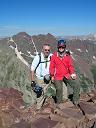
summit of Pennsylvania
summit of Pennsylvania
I made quick work of the ascent and was glad to have known to go around the false summit instead of wasting time and energy just to descend it all on the way to the true summit. Topping out at 2:45 it felt great knowing I only had a short descent to go and y big day was a success. The views from the summit were gorgeous and it's always nice to see so many peaks that I have already climbed. Mt. Evans B looked enticingly close, but I decided to wait and get that when I am up getting Gemini, Dyer and West Dyer in the not so distant future(next week anyone???).
Sherman group
Sherman group
I made it back to the snowshoe stash in no time and only had one last mile back to the car. Somehow the snow conditions got worse and I was reminded that there are no free lunches when snow is involved. Finally made it back to the car at 4:00 for a sporting 2 and a half hour time on Pennsylvania Mountain. Driving home on 285 was great knowing that I wasn't dealing with ski traffic on I-70 and I made it home at 6:00 just in time to shower and go for Mexican food where I ate more than I have in a long time. Overall, an amazing day in two ranges, and a whopping 31 13ers in just 22 days, I doubt I will ever have the opportunity to do that again!
Thumbnails for uploaded photos (click to open slideshow):
We've got the same itinerary lately 3/26/2012 2:07pm
It seems like we're thinking along the same lines. These we on my radar recently. Just haven't gotten over there yet. Thanks for the good info. And congrats on an incredible few weeks!
Fifteen 13ers in 4 days! At that pace you could climb them all in 6 or 7 months. You won't do it. : )
Caution: The information contained in this report may not be accurate and should not be the only resource used in preparation for your climb. Failure to have the necessary experience, physical conditioning, supplies or equipment can result in injury or death. 14ers.com and the author(s) of this report provide no warranties, either express or implied, that the information provided is accurate or reliable. By using the information provided, you agree to indemnify and hold harmless 14ers.com and the report author(s) with respect to any claims and demands against them, including any attorney fees and expenses. Please read the 14ers.com Safety and Disclaimer pages for more information.
Please respect private property: 14ers.com supports the rights of private landowners to determine how and by whom their land will be used. In Colorado, it is your responsibility to determine if land is private and to obtain the appropriate permission before entering the property.


 Sunrise")
 Sunrise")
 Grays and Torreys")
 Santa Fe Peak")
 Santa Fe summit")
 Santa Fe summit")
 Tenmile Range")
 Sullivan summit looking to Santa Fe")
 Looking to Geneva")
 Geneva Peak")
 summit of Geneva")
 summit of Geneva")
 summit of Landslide")
 summit of Landslide")
 descent gully")
 descent gully")
 Snowshoe Hare")
 Valley to Montezuma")
 fox in middle of picture")
 Montezuma")
 Hammertime")
 Eco-friendly bike rack")
 snowshoe stash on Pennsylvania Mtn")
 summit of Pennsylvania")
 summit of Pennsylvania")
 Sherman group")
 Sherman group")