Download Agreement, Release, and Acknowledgement of Risk:
You (the person requesting this file download) fully understand mountain climbing ("Activity") involves risks and dangers of serious bodily injury, including permanent disability, paralysis, and death ("Risks") and you fully accept and assume all such risks and all responsibility for losses, costs, and damages you incur as a result of your participation in this Activity.
You acknowledge that information in the file you have chosen to download may not be accurate and may contain errors. You agree to assume all risks when using this information and agree to release and discharge 14ers.com, 14ers Inc. and the author(s) of such information (collectively, the "Released Parties").
You hereby discharge the Released Parties from all damages, actions, claims and liabilities of any nature, specifically including, but not limited to, damages, actions, claims and liabilities arising from or related to the negligence of the Released Parties. You further agree to indemnify, hold harmless and defend 14ers.com, 14ers Inc. and each of the other Released Parties from and against any loss, damage, liability and expense, including costs and attorney fees, incurred by 14ers.com, 14ers Inc. or any of the other Released Parties as a result of you using information provided on the 14ers.com or 14ers Inc. websites.
You have read this agreement, fully understand its terms and intend it to be a complete and unconditional release of all liability to the greatest extent allowed by law and agree that if any portion of this agreement is held to be invalid the balance, notwithstanding, shall continue in full force and effect.
By clicking "OK" you agree to these terms. If you DO NOT agree, click "Cancel"...
I hope that everyone is continuing to enjoy the remarkable weather this early Spring. While our snowpack has rapidly melted to 50% of normal depth and coverage, it sure does feel nice to be warm and comfortable on the trail.
On Wednesday, I set out on a tour of the Blue Lakes Basin immediately southwest of Quandary Peak. What started as a relaxed attempt to reengage in mountaineering with aching knees turned into a spectacular loop over Centennial Fletcher Mountain, including a descent of its steep NE Couloir.
I started walking 3/4 of a mile below the Blue Lakes Dam at dawn. The air was crisp following the previous day's disturbance that left a dusting of snow in the higher peaks of the Southern TenMile. The road to the dam held brief patches of deeply frozen snow, a minimal impedance towards the basin. As I gained the dam, the Sun peaked above the silhouette of neighboring Hoosier Ridge, illuminating a wonderful place.
I made my way around the North Side of Upper Blue Lake (a rather inefficient way to travel a few hundred yards - I recommend the South Side for those traveling this path in the future), put on my splitboard, and began a slowly ascending westward path towards intimidating Wheeler Peak.
Looking eastward from the base of North Star Moutain's North Couloir ignited a deep sense of benevolent isolation.
Following a methodical set of leg stretches done with the hope of alleviating the building tension in my knees, I continued onward; contouring gently up and gradually north along Monte Cristo Creek. My eyes were drawn towards the sky as couloir after face after chute revealed itself. The ridgeline between Wheeler and Drift Peaks holds a multitude of routes for the interested mountaineer. Spectacular Country.
Soon this Winter's lack of precipitation stripped the planks from my feet, forcing a slow bootpack over rime coated talus. At times I found my frustration growing - when a rock slipped, when gravity overcame balance - but those moments were fleeting. A cautious happiness took hold as I ascended towards the pathetically bare South Face of Fletcher Mountain.
Sometime around 10:00am, I took the final slippery steps to Fletcher's Summit. The panorama was truly breathtaking - the entire Front Range was visible to the East, as was the rugged Gore to the North, the Mosquitos to the South, and the powerful Sawatch and prominent Elk's to the West. All right!
I felt good. Deeply and profoundly good. The kind of contentment that comes with uncertainty and a forced tempering of a beloved pursuit. My knees had held to the summit (albeit one that necessitated less than five miles of approach and 3,000 feet of climbing), but I was there, and I was happy.
The snowboard found its way back to my feet, and I connected snowpatches down the southeast ridge of Fletcher. After a few minutes of something resembling snowboarding, I found myself staring down a nice looking, Northeast Facing couloir.
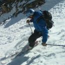
The entrance was steep, the surface conditions less than certain, and the line just off-fall line enough to reward a mistake with a rock wall ricochet. My mind started playing the what-if game that comes with risk assessment and the associated decision making; I have a feeling all of us have been there multiple times. After after a few minutes of contemplation, deep breathing, skill assessment, and planning, I decided to drop over the edge. Sure, the first 50' involved a healthy portion of toeside slipping, but the turns and safe descent thereafter more than made up for it. The cold steel edges of my chosen tool dug into the softening variable surface, sending mesmerizing cascades of tumbling granules into the basin below. I found my rhythm and etched my name into the side of Fletcher. It felt good.
The climb back up to the Quandary-Fletcher saddle passed quickly, requiring crampons but hardly lasting long enough to stall the momentum of the line. I found myself fascinated with the symmetries of a steep bootpack, and brought the camera back out for a closer look.
I spent the next hour and a half hike-boarding underneath Quandary's Southwest face. There was enough snow to grab a few sets of satisfying sun-baked turns before the snowline was reached.
Thanks, and peace be the journey,
Brennan
Sharing mountain adventures with this community is a real privilege, so thank you for reading. If you enjoyed this report, and desire to enable our community to help change the lives of Children with Burn Injuries, please visit the Peaks for Peace Website and consider making a donation to a powerful cause!
Thumbnails for uploaded photos (click to open slideshow):
The choke near the top is no longer in, and consists of a few inches of sugar snow on top of rocks and ice. Marc, being the sole boarder and perhaps the wisest of the group, carried his board down from the summit ridge and strapped in below the crux. The rest of us tried to ski through it and ended up removing the planks and downclimbing, which involved a transition on steep terrain that was a tad hairier than any of us signed up for. Someone with gigantic gonads could maybe get through if they were willing to side huck several vertical feet onto steep terrain, but that was not us.
From below the crux however the skiing was good all the way to the car. I might do a TR but if I do it won't be for a few more days. This season is driving me nuts!
Caution: The information contained in this report may not be accurate and should not be the only resource used in preparation for your climb. Failure to have the necessary experience, physical conditioning, supplies or equipment can result in injury or death. 14ers.com and the author(s) of this report provide no warranties, either express or implied, that the information provided is accurate or reliable. By using the information provided, you agree to indemnify and hold harmless 14ers.com and the report author(s) with respect to any claims and demands against them, including any attorney fees and expenses. Please read the 14ers.com Safety and Disclaimer pages for more information.
Please respect private property: 14ers.com supports the rights of private landowners to determine how and by whom their land will be used. In Colorado, it is your responsibility to determine if land is private and to obtain the appropriate permission before entering the property.


")
")
")
")
")
")
")
")
")
")
")