| Peak(s): |
Mt. Democrat - 14,154 feet Clinton Peak - 13,866 feet McNamee Peak - 13,784 feet |
| Date Posted: | 04/26/2012 |
| Modified: | 08/07/2012 |
| Date Climbed: | 04/22/2012 |
| Author: | SnowAlien |
| Peak(s): |
Mt. Democrat - 14,154 feet Clinton Peak - 13,866 feet McNamee Peak - 13,784 feet |
| Date Posted: | 04/26/2012 |
| Modified: | 08/07/2012 |
| Date Climbed: | 04/22/2012 |
| Author: | SnowAlien |
| A weekend near Montgomery reservoir |
|---|
|
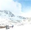
My first 13er and 14er ski descents Day 1 - 04/21/12 Route: Clinton Peak - McNamee - re-ascent of Clinton Peak Stats: 9.7 RT, 9 hours (with a lot of stops to enjoy the scenery), net elevation gain: ~3,800 maximum speed: 23 mph (yay!) Party: me and CMC HAMS (Rainier team) I was excited to join my Rainier team on a training hike up Clinton Peak - McNamee- Traver on Saturday. I was curious to see the conditions on Mt. Democrat which I considered skiing the next day and was also interested to add a few peaks (including a Centennial) to my admittedly short 13er list. Brief research of the route revealed that there are a few skiable options on those peaks. I was debating about bringing skis/not bringing skis (since the spring snow conditions have been so thin) until we pulled into the Montgomery reservoir TH and the snow capped peaks in the Platte river basin revealed themselves. For the first couple of miles the skis stayed on the pack. However, about a mile down from the Wheeler lake, I was able to start skinning. On a gentle terrain, it turned out to be a much more effective method of travel than ankle-deep post-holing, and the rest of the group followed my tracks. My bliss did not last long though. The snow climb was on the agenda and the skis went on the pack. The first look at the Clinton Peak summit revealed that the summit ski was in. There were also options for a ski descent off McNamee, so I made the quick ridge run there to overview the potential descent routes. The heavily corniced ridge made me retreat back to Clinton, while the rest of the ski-less group proceeded to Traver. Strong winds (which knocked me off my feet a couple of times on the ascent) kept the snow from warming well into the day. The sun was able to warm up just the very thin top layer of the snow, providing for a silky smooth surface. I picked the line directly off the Clinton Peak summit, closer to the rocks, which largely left the cornices to the skier's right. The first few turns were a bit steeper than the rest, but then the angle mellowed out and the perfect snow conditions made for a fun and quick descent into the basin. Once in the basin, I was able to pick the route that allowed me to keep the skis on for the most part, as I cruised down to the snowshoe stash and waited for the rest of the group. The descent down to the Wheeler lake provided a few additional steep turns, and then I was able to ski a few more miles on the trail. For the last 2 miles the skis had to go back on the pack. Clinton Peak Ski                Day 2 - 04/22/12 Route: Up - South slope snow route (Emma Lake chutes), Down - variation of the SE face down to the Kite Lake. Stats: 3.7 RT, 6.5 hours (with about 1.5 hours enjoyed on the summit), net elevation gain: ~2,500, maximum speed: 24 mph Party: me and Hugh I had the fortune to partner up with the "Amazing Hugh" for the snow climb and ski of Mt. Democrat. We started from Kite Lake TH at 8.30am. On a warm day like that we should have probably started an hour earlier (although in the end we did not have major problems with postholing). Any later and the snow ascent would have been problematic. We picked our way to Lake Emma by skinning up, switching to crampons to climb the headwall to Lake Emma, and then choosing one of the chutes for the snow climb. As we climbed out of the chute, we agreed that the steepness of the slope was pushing our (mostly mine) comfort level for the ski descent and we needed to find an alternative route. The rest of the route to the summit was straightforward and would not be a problem for either of us. We arrived at the summit to the amazing views shortly after 11.30am. We noticed the rest of our large ski group (who arrived at the TH and started at least an hour or later behind us) ascending the SE Ridge. Upon arrival, they reported skinning all the way up from the car (see scramble's report), so we assumed there will be a continuous and relatively mellow line down to the Kite Lake. Hugh and I joined the rest of the group for the descent down the SE face around 1pm. The snow conditions were very different from the day before. Temperatures in the upper 40ties and almost no wind made the snow heavy, slushy and chunky. Descending skiers left deep ruts in the snowpack. Large snowballs were forming. I made sure to go slow to avoid any mistakes near the top, but as the angle relented, there were some fun turns to be had! Still, the snow conditions compared very unfavorably to the day before. I descended the direct line down to the Kite Lake, enjoying a few more turns in the mid-30ties in the slushy snow, while the rest of the group picked a more gentle line that avoided additional traversing on the flat terrain. Mt. Democrat Ski   above Lake Emma")     side of Traver Pk")          Takeaways: - Huge thumbs up to my Scarpa Maestrale/Gea AT ski boots - hiked/skied nearly 14 miles in them this weekend, and no blisters or hotspots. - Wind makes a BIG difference in snow conditions day-to-day, given the same air temps. - Competent partners are a joy to climb with (duh!). - Wish we had more snow this winter. While I was trying to ski the steeper terrain, it occurred to me that I had not skied any back bowls at the resorts this season, as they were fenced off for the lack of snow. - Skiing high peaks is a great fun and the most efficient way to travel in the BC. - Chocolate milk seems to work as a recovery drink - tried it for the 1st time and felt better than anticipated on the 2nd day of climbing. No apparent side effects too. Thumbnails for uploaded photos (click to open slideshow):  First look at the basin")
 North Face of Mt. Democrat")
 Pictures do not do it justice. Lake Wheeler is gorgeous!")
 The group following my skin tracks")
 Higher in the basin")
 Snow climb")
 Remaining route to Clinton Pk and McNamee. Summit ski is in!")
 Mt. Democrat - North face")
 View of Traver from McNamee")
 The road back to Clinton Pk")
 Dropping in.")
 Point of no return")
 Ski tracks")
 Skiing out of the basin")
 Tracks above Lake Wheeler")
")
 Snowballs (frozen) above Lake Emma")
 Climbing one of the chutes")
 Buckskin-Democrat ridge")
 Mt. Arkansas with prominent N. Couloir")
 Prior day's work - Clinton Pk, McNamee and the snowy(!) side of Traver Pk")
 First part of the group climbing up the SE ridge")
 Ready to ski")
 Getting off the summit is the easy part!")
 And now I am expected to ski this. Rrright.")
")
")
 Not too bad now")
 Wet snow above the Kite lake. Slushy turns.")
 SE face with our ski tracks")
|
| Comments or Questions | ||||||||||||
|---|---|---|---|---|---|---|---|---|---|---|---|---|
|
Caution: The information contained in this report may not be accurate and should not be the only resource used in preparation for your climb. Failure to have the necessary experience, physical conditioning, supplies or equipment can result in injury or death. 14ers.com and the author(s) of this report provide no warranties, either express or implied, that the information provided is accurate or reliable. By using the information provided, you agree to indemnify and hold harmless 14ers.com and the report author(s) with respect to any claims and demands against them, including any attorney fees and expenses. Please read the 14ers.com Safety and Disclaimer pages for more information.