Download Agreement, Release, and Acknowledgement of Risk:
You (the person requesting this file download) fully understand mountain climbing ("Activity") involves risks and dangers of serious bodily injury, including permanent disability, paralysis, and death ("Risks") and you fully accept and assume all such risks and all responsibility for losses, costs, and damages you incur as a result of your participation in this Activity.
You acknowledge that information in the file you have chosen to download may not be accurate and may contain errors. You agree to assume all risks when using this information and agree to release and discharge 14ers.com, 14ers Inc. and the author(s) of such information (collectively, the "Released Parties").
You hereby discharge the Released Parties from all damages, actions, claims and liabilities of any nature, specifically including, but not limited to, damages, actions, claims and liabilities arising from or related to the negligence of the Released Parties. You further agree to indemnify, hold harmless and defend 14ers.com, 14ers Inc. and each of the other Released Parties from and against any loss, damage, liability and expense, including costs and attorney fees, incurred by 14ers.com, 14ers Inc. or any of the other Released Parties as a result of you using information provided on the 14ers.com or 14ers Inc. websites.
You have read this agreement, fully understand its terms and intend it to be a complete and unconditional release of all liability to the greatest extent allowed by law and agree that if any portion of this agreement is held to be invalid the balance, notwithstanding, shall continue in full force and effect.
By clicking "OK" you agree to these terms. If you DO NOT agree, click "Cancel"...
Missouri Mtn. Ski Descent (North Face Direct) - Missouri Gulch TH
Missouri Mtn. North Face (main) Couloir Ski
Date: Wednesday, April 25, 2012 Crew: Bill and myself Route: Northwest Ridge (standard) ascent and North Face Direct Couloir ski descent from Missouri Gulch TH Stats: 9 miles; 4,500' climbed; 2,300' skied; 9 hrs 45 min RT
Overview of our routes, photo taken in 2007 (red=climb; blue=ski):
Topo of the route (red=climb; blue=ski):
I have to selfishly admit that I've been out climbing a lot since January, and every time I've been out, I've had awesome days - be it great weather, routes, partners (and all that goes along with that), and overnight camps. Well, yesterday was nothing short of that either. Enter prime 14er ski conditions in addition. It's no secret that Colorado has had a tough year for snowpack and backcountry ski conditions, but, wow - we found some goods! I left work Tuesday night and met Bill at the Missouri Gulch TH where we got a few hours of sleep before a 3:30am alarm. We started up trail at 4:50am and made great time up the switchbacks to the cabin and stopped for a quick break. A lot of the trail is dry to here and for the snow packed sections no flotation is necessary. We continued through Missouri Gulch basin (snow-covered) and got a better look at Missouri. The original plan was to climb the "C Couloir" (still planning to ski the main couloir) but I forgot my crampons. Even though there was boot or glissade track, we knew the safer option was to climb the standard NW ridge.
Good morning, Missouri!
Bill makes his way before Mt. Belford up Missouri's west slopes to our shoe stash at 12,900':
The wind in the basin kept things cool - we didn't feel pressed for time. At 12,900', we cached our hiking shoes and switched to ski boots. Traversing towards Point 13,784' and the visible, summer trail, we reached the base of the slope leading to the ridge and were greeted with several rocks that kept flying down from above at high speeds. Low on the slope we started post-holing a bit and poked around in the snow to find depth hoar sandwiched between two icy layers all on top of sugar snow. So we headed climbers' right a little further and encountered minor post-holing in shallow snow. We then decided to aim for the large dirt patches in the center of the slope to reach the ridge. That option was much better.
After testing some snowpack and unfavorable post-holing, it was easiest to climb the dirt patches to reach the saddle:
It was warm and after attaining the saddle, a nice breeze felt great along the summit ridge. And of course, Huron Peak's East Face dominated our views. From this saddle at 13,700', we followed the standard route to the summit (snow can be avoided on most of the route). About halfway across, we took a peek down the "C Couloir" - looks like a nice mellow ski, but the entrance was not continuous.
At the saddle, Huron's East Face lines look inviting - Can we ski this next please please please, Bill?!
Looking down the mellow "C Couloir" from the ridge, just north of the main couloir:
Looking back (north) along the Northwest Ridge:
Bill walks the long ridge before reaching the summer crux:
At the "crux" of the summer route, we had to traverse two short snow slopes before the final pitch to the summit. The first snow slope had previous boot tracks, but Bill made our own on the second - great snow for kicking steps.
From the crux, Bill starts across a previous boot track on one of two snow slopes we crossed:
I cross the second slope; Bill kicked steps and I followed:
The final pitch to the summit. The entrance to the north face direct couloir is the immediate snowfield in the photo:
Shortly after, we topped out on Missouri at 11:00am. If there is such a day as 'perfect', this was as close to it as it could get. We had zero wind, a pleasant temperature, blue skies, and views of some of Colorado's most beautiful snow-capped peaks. I Tebowed.
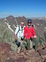
My requisite fish-eye summit shot - Mt. Harvard splits us in the distance on another stunning day:
After a nice hour break of food, ski-waxing, and photos, we left the summit at 12:00pm, clicked in at the highest point possible and entered the top of the main North Face Couloir. The upper portion of this couloir seemed a bit loaded, so Bill made ski-cut skiers' right side of the couloir and made a few solid jump turns to test snowpack out only to find some awesome powder on top of a solid base. Even though it was very stable, sloughing powder was the snowpack demeanor in this awesome upper 2/3 of the couloir. It was SWEET!
This entrance to the couloir was a bit loaded, so Bill made a ski-cut and a few jump turns to skiers' right where we found the powder:
I follow Bill's ski-cut to the first safety zone...
...and find me some wonderful blown-in powder to slice!
Bill getting his blower:
Bill at a safety zone, about half way down the couloir:
I can't remember if I've already mentioned that we had some awesome powder in the upper 2/3 of this couloir? We did - not something you typically see on a 14er and made for near effortless turns. Bill estimated the max slope we skied was no more than 40 degrees (near the middle of the couloir), and the rest averaged mid to upper 30's. The bottom 1/3 and apron consisted of some nice spring corn - another treat and more unforced turns!
I ski some nice corn in the bottom of the couloir and out towards the apron:
Bill makes it look easy (as always) and exits the apron:
Once we hit the couloir apron, we immediately contoured skiers' left to stay high in the upper basin to hit some short, small chutes that would drop us back at our shoe stash. Bill chose the chute on lookers' left, I chose the one on the right. Both chutes were hard-pack.
A train of slough, two happy skiers, North Face shredded:
Our routes down the North Face and small chutes to our shoes at 12,900':
It took us 20 minutes to return to the shoes. We were all smiles and pretty thrilled to have encountered the conditions we just did. We debriefed the ski descent and concluded that we don't think we could have timed it much better and that this was one of the best backcountry days we've had this season, once again because of the great snow. Oh wait, we still had 1,100' more feet of corn skiing ahead of us! We skied very mellow terrain, and had to pop the skis off for 20 feet to enter the drainage. After more mellow corn turns, we milked the skiing as best we could until willows and rocks stopped us at 11,800' for a quick change of gear. Of course we had more post-holing and bush-whacking to reach the Belford trail, but it didn't seem to irritate us as much as it did on Challenger - I wonder why! From the cabin, it took us 45 minutes to get back to the trailhead, where we arrived at 2:30pm. It was such an all-around awesome day and even better to find great snow; I almost felt undeserving of it. Thanks again, Bill, for another excellent day and for the repeat ski - I owe you one!
My GPS Tracks on Google Maps (made from a .GPX file upload):
RJansen77: #22 is a nice powder shot indeed! Effortless turns.
Otina: I told Bill on several occasions that I put a ban on people taking my ski shots until further notice, but it clearly went over his head. I'm somewhat glad though, because they turned out slightly better. So I guess Bill automatically lifted my own ban for me. And - moratorium - thanks for the new vocab word!
Rainier_Wolfcastle: my partner was the one showing off on the ski, not me! I have an abundance of vacation time to use, so a mid-week ski was needed.
Brian: Thank you! I kept thinking about our conversation the previous day saying that we missed a sweet day on Torreys with you; well, as I was writing this TR, I was going to tell you the same thing!
primary332: Go get after Huron!
Bill: I'm the one who should be thanking you for the repeat 14er ski! Legit day in my book!
Ben: Thank you! We really do need to ski before this season ends.
Dad: As always, thank you for your support! It has undeniably been a killer year above treeline so far - I feel Mom's presence with me every trip.
Greg: What Bill said! I'll even supply you with some Propylene Glycol to stick in your ski boots to make sure your toes don't freeze!
Question. We are going to ski either Missouri or maybe Huron Monday and was wondering if the road to the Missouri trailhead is accessible with a Subaru?
Thanks for the great post! Hopefully your turns filled in!
Hey! Yes, the road to the Missouri TH is completely clear of all snow and you should have no problem in a Subaru - it's just the typical washboard-ed out!
Also, make sure you check this thread out if you haven't already:
Hope you get some good conditions on which ever peak you decide on!
For taking the time to put this together. It was really helpful. Way to find the goods!
Caution: The information contained in this report may not be accurate and should not be the only resource used in preparation for your climb. Failure to have the necessary experience, physical conditioning, supplies or equipment can result in injury or death. 14ers.com and the author(s) of this report provide no warranties, either express or implied, that the information provided is accurate or reliable. By using the information provided, you agree to indemnify and hold harmless 14ers.com and the report author(s) with respect to any claims and demands against them, including any attorney fees and expenses. Please read the 14ers.com Safety and Disclaimer pages for more information.
Please respect private property: 14ers.com supports the rights of private landowners to determine how and by whom their land will be used. In Colorado, it is your responsibility to determine if land is private and to obtain the appropriate permission before entering the property.


")
")
")
")
")
")
")
")
")
")
")
")
")
")
")
")
")
")
")
")
")
")
")
")
")
")
")
")
")
")
")
")
")