Download Agreement, Release, and Acknowledgement of Risk:
You (the person requesting this file download) fully understand mountain climbing ("Activity") involves risks and dangers of serious bodily injury, including permanent disability, paralysis, and death ("Risks") and you fully accept and assume all such risks and all responsibility for losses, costs, and damages you incur as a result of your participation in this Activity.
You acknowledge that information in the file you have chosen to download may not be accurate and may contain errors. You agree to assume all risks when using this information and agree to release and discharge 14ers.com, 14ers Inc. and the author(s) of such information (collectively, the "Released Parties").
You hereby discharge the Released Parties from all damages, actions, claims and liabilities of any nature, specifically including, but not limited to, damages, actions, claims and liabilities arising from or related to the negligence of the Released Parties. You further agree to indemnify, hold harmless and defend 14ers.com, 14ers Inc. and each of the other Released Parties from and against any loss, damage, liability and expense, including costs and attorney fees, incurred by 14ers.com, 14ers Inc. or any of the other Released Parties as a result of you using information provided on the 14ers.com or 14ers Inc. websites.
You have read this agreement, fully understand its terms and intend it to be a complete and unconditional release of all liability to the greatest extent allowed by law and agree that if any portion of this agreement is held to be invalid the balance, notwithstanding, shall continue in full force and effect.
By clicking "OK" you agree to these terms. If you DO NOT agree, click "Cancel"...
Ellingwood Peak gets little respect and is underappreciated. It is far easier to climb as an add on to a trip up Blanca or Little Bear and most people seem to climb it that way. Indeed that was my initial plan last July but thunderstorms and a few lightning bolts had been pretty effective at changing my mind quickly and I never was able to climb it on my last trip out and was only able to climb up Blanca Peak. On this trip I would specifically target this mountain.
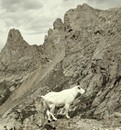
Below is a great shot of Ellingwood on the approach from above Lake Como.
I underestimated Ellingwood. My only memory of the specific route was the short pitch and scramble up from the saddle coming off of Blanca, which as many of you know, is a fairly short Class 2-3 climb up, or Class 4 if you get off-route. Nonetheless, even off-route from the saddle it is not a long climb. Starting from the base of the road, however, it takes upon a greater dimension for an ultra-day hike, climbing over 6,000 feet and ~16 miles roundtrip with the hardest part as usual, being the final 600-800ft to the top.
I figured as the monsoon season hadn't really started, I could get away with starting a bit later. Getting a lazy late start at the trailhead at 5:00AM, I started hiking the approach up in the remaining starlight to the sounds of coyotes howling to one another across the San Luis Valley and desert. There were various barks and cries and some other noises I wasn't able to identify.
An occasional "Moo" from one of the nearby cows added to the early morning chorus. I think they were all laughing at me for walking up this darn road again.
To give you an idea of the elevation differential that this climb takes on and the environments you will pass through; recall that while at or near the summits of Ellingwood, Blanca and Little Bear, you will have an exceptionally harsh alpine environment. Any plants growing there will be stunted and lower down the trees will be permanently windswept taking on a krumholz pattern. At the base of the road, however, you have flowering cactus
growing:
Lake Como road as you know, reaches up to over 12,000ft, with a 4,000ft gain in itself and is a harder walk up than many Sawatch Fourteeners, and you haven't even gotten to the flanks of the peak yet. No wonder the cows were laughing at me.
Since the road makes up so much of this climb, it makes sense to show some shots!
For the first 3-4 hours expect to see this:
There is a short reprieve from the monotonous boulder strewn path in the form of a nice aspen grove that you will walk through
You'll pass three or four antique looking rustic cabins, evidencing the Pioneering history of our country, which adds some character to the road.
As any good trail, I mean road, has, you'll have some stream crossings as well. This one proved pretty uneventful. No need to stop for water here, there is plenty higher up which is in all likelihood cleaner.
In a visually stunning moment as you near treeline, Lake Como finally comes into view as does the west ridge of and the summit of Little Bear (note I took this shot actually coming down, after some weather started moving in). Skies were clear earlier that morning. Two marmots ran across the road. There seemed to be a lot of them around this morning, more than I've ever seen.
I'd like to say the hike up the road went quickly and fast, but it didn't. It felt long and tiring and starting so late, became pretty warm very quickly. I made good time and was up by lake around 8:30AM. The last time I was on this road, I had a bear spray episode (see my Blanca trip report for details). Luckily, the morning proved to be fairly uneventful this time around. I did see three Black Vultures circling me all morning, wondering if they knew something I didn't.
Arriving at the basin was a treat. This alpine cirque-like area is just beautiful and was a great place to just chill for a while and take it all in. It was a perfect time to have a breakfast Powerbar and refill some water in the creek up there. The air was brisk yet fresh, several marmots were running around (again, where did all these guys come from??!) and Ellingwood becomes visible to the east, framing the back of the basin in a postcard view.
The ground was wet and icy in spots, and while there was some snow drifts in the forest above the lake, there was no snow to speak of yet on the trail which caused any issues walking up.
There was more snow as I climbed into the area above Crater Lake the lake itself was pretty frozen over. The smaller lake before this was partially frozen and the two small lakes (Blue Lakes?) were ice free as shown above.
Once you get to the end of the flat area and past the few picturesque lakes, the terrain starts to become a bit more rough. More snow is present in the deeper spots in the basin, higher drifts are formed against the northern slopes of the Little Bear/Blanca ridge and there are several snowfields you must cross while climbing to the saddle.
It was at this point, that I realized that I was on the way up the Blanca Trail and stayed on it too long before turning off. I still could have turned off higher up to shoot over to Ellingwood from the Saddle, but it was extra mileage and gain that I didn't need to do today. I also would have had to cross a steep snowfield with the snow in less than optimal condition.
I noticed a few folks coming down from the summit of Ellingwood. I stopped and waited to see their descent route. As it turns out, there were maybe a dozen of them, and they made their way down in three or four different places, which didn't seem to make sense at the time as none seemed to be coming down from where I ascertained the "route" to be. I waited until they came closer, when after speaking to them, it made more sense.
They were all part of a Special Forces team doing their mountaineering training on the mountain today. I thought that was pretty cool! I wish I could have climbed with them and spent more time chatting, but we were moving in opposite directions. They had camped out at the lake the night before, had an early start today and were eager to get back, while I was eager to get up. Seeing our elite fighting forces training on the day gave me a renewed energy and with my second wind, I pushed up the remainder of the route up towards the summit. Any fatigue I felt vanished.
I should note that to get to Ellingwood after entering the basin above the ledges, there seems to be several ways up, but none that seemed very defined and it seemed more like a "pick your line and go" situation. I opted to go straight up the bottom of the valley aiming for the Blanca-Ellingwood saddle and then veer northeast a few hundred feet before reaching the saddle where one of the snowfields ended. I crossed two large snowfields here, which in the late morning, were soft enough to not warrant crampons. There was also some snow obscuring the trail near the junction where you turn left (north/East) to Ellingwood, which made routefinding tricky, but I just retreated a few hundred feet and headed back up to climbers left.
Ellingwood really comes to dominate the view now. What a magnificent looking mountain.
A nice shot of Ellingwood's southwest face:
I don't think the route I chose was any standard route, as it was filled will pretty miserable talus, though I did pass a small cairn here and there, probably more by chance than anything. There were some walls I needed to climb up that were Class 3 on loose rock, perhaps Class 4 (making me realize I was definitely not on a standard route), but this rock, while steep provided some respite from the loose choss and talus that was taking a mental toll on me as I climbed up.
I wanted to actually climb that thin snow line that lead up near the summit, but the snow at this time was in rotten shape and not safe to climb. I tried taking a few steps and I sunk to my waist. Thus, I stayed on the rock/talus/choss and climbed up a line I created for myself to the subsummit aiming for the real summit further west.
Soon I was on top!
Wow, this climb took a lot out of me. I have more respect for this seemingly "easy" peak after the long day starting from the bottom of the road. Again, I was alone on the summit, with nobody else in sight, my own private mountain for the day. My Summit Snickers was gnawing a hole in my pocket, begging to be eaten so I quickly downed that and took some photos.
From the top, I could see the Crestones in the distance to the north and Lindsey to the east. Staring in front of me was Blanca and Little Bear in all their mighty glory. What a cool place.
You have a stunning view of sharp-edged Blanca Peak from the summit
..and of the aggressive profile of Little Bear
Ellingwood's summit is not large. Looking at the photo that I took from Blanca last Summer, one can see how steep and narrow this peak is; Very ridgey/fin-like. Ellingwood reminds me of the dinosaur Dimetrodon in its shape.
Heading down, I took a different route and dead reckoned for the snowfield between Ellingwood and Blanca. One has to be careful not to follow a line down near those cliffs on the south face, so I was careful here and took each step with caution, eventually encountering that ugly talus and scree, then downclimbed two steep rock sections with water running down them, which made things a bit more interesting, but was better that postholing in the snow which appeared in a few spots.
Towards the bottom, I picked up other faint segments of a trail which led around the lakes to the north which seemed to be a better route to return on.
In short, if you haven't done Ellingwood or were putting it off, go check it out, it is definitely worth the trip, it is a really a great peak, with a true alpine look upon seeing it coming up from Lake Como and you will definitely gain more appreciation for this wonderful mountain when doing it by itself as a one day trip!
Thumbnails for uploaded photos (click to open slideshow):
Enjoyed the perspective of this climb. And it's nice to see other photos of that road besides ”Jaws”. A beautiful, but (as you pointed out) underappreciated peak. Thanks
Great pictures, good quality and good perspective- are those straight off your camera? (which camera?) That is a LOOONG dayhike, you must be in really good shape! We might do this next weekend so this will be valuable information.
About how long did this take you? I've considered doing Ellingwood as a day trip, but tackling the road as well as the peak in one day sounds daunting.
keep on getting after it. nice work for an east coaster...
i enjoy reading your reports. and yes, not much snow left in the southern Sierra. there is more snow now in Tahoe at 9,000 feet than in the Whitney Zone at 13,000 feet.
Not sure whether congrats or condolences are more appropriate on doing it all the way from the bottom. Definitely kudos for going solo. We did Blanca from the bottom, so I know, yes, it makes for a _long_ day! (And it's a neat peak.)
You can buy me a dinner, but it will be eaten by bears, I am afraid.
Caution: The information contained in this report may not be accurate and should not be the only resource used in preparation for your climb. Failure to have the necessary experience, physical conditioning, supplies or equipment can result in injury or death. 14ers.com and the author(s) of this report provide no warranties, either express or implied, that the information provided is accurate or reliable. By using the information provided, you agree to indemnify and hold harmless 14ers.com and the report author(s) with respect to any claims and demands against them, including any attorney fees and expenses. Please read the 14ers.com Safety and Disclaimer pages for more information.
Please respect private property: 14ers.com supports the rights of private landowners to determine how and by whom their land will be used. In Colorado, it is your responsibility to determine if land is private and to obtain the appropriate permission before entering the property.


")
")
")
")
")
")
")
")
")
")
")
")
")
")
")
")
")
")
")
")
")
")
")
")
")
")