Download Agreement, Release, and Acknowledgement of Risk:
You (the person requesting this file download) fully understand mountain climbing ("Activity") involves risks and dangers of serious bodily injury, including permanent disability, paralysis, and death ("Risks") and you fully accept and assume all such risks and all responsibility for losses, costs, and damages you incur as a result of your participation in this Activity.
You acknowledge that information in the file you have chosen to download may not be accurate and may contain errors. You agree to assume all risks when using this information and agree to release and discharge 14ers.com, 14ers Inc. and the author(s) of such information (collectively, the "Released Parties").
You hereby discharge the Released Parties from all damages, actions, claims and liabilities of any nature, specifically including, but not limited to, damages, actions, claims and liabilities arising from or related to the negligence of the Released Parties. You further agree to indemnify, hold harmless and defend 14ers.com, 14ers Inc. and each of the other Released Parties from and against any loss, damage, liability and expense, including costs and attorney fees, incurred by 14ers.com, 14ers Inc. or any of the other Released Parties as a result of you using information provided on the 14ers.com or 14ers Inc. websites.
You have read this agreement, fully understand its terms and intend it to be a complete and unconditional release of all liability to the greatest extent allowed by law and agree that if any portion of this agreement is held to be invalid the balance, notwithstanding, shall continue in full force and effect.
By clicking "OK" you agree to these terms. If you DO NOT agree, click "Cancel"...
Mighty Finnback Knob - 13,409 feet
149 whole feet of Prominence
June 23, 2012
Trailhead: Gold Basin, which is just west of Weston Pass. We followed Roach's directions for this TH, which is also used for Horseshoe Mountain, though we thought it wasn't quite as far down the road from Weston Pass as what Roach says. This was 2WD on Weston from the East up to the turnoff. Then 4WD up the road leading away from the Weston Pass road. Route: Up toward Horseshoe Mountain and then over to Mighty Finnback Knob when the time seemed right. Distance: ~4.6 miles Elevation gain: 2,300 feet Who: Bob and Kate "Finn"
Several people have asked us if we've hiked Finnback Knob yet, since, you know, it's sort of our name. The answer has been no. Why had we not? Various reasons. We were running out of excuses when suddenly we could avoid it no longer. Sure, it's an unranked peak, but as you will see, there was adventure to spare on this hike.
The first time we had thought about this hike was the Spring Gathering several years ago, but after summiting Finnback's false summit, Horseshoe Mountain, we were a bit winded and we wanted to finish the rest of the Peerless Group.
So, why hadn't we hiked this mountain? Well, for one thing, it's nowhere near a 14er trailhead. Aren't all trailheads 14er trailheads? A trailhead for a 13er is like a trailhead on Dantooine - far too remote. Those trailheads are scary and hard to find and difficult to get to. We were apprehensive about driving somewhere where there wouldn't be 40 other cars. Eventually, after amassing our courage, we took the leap and headed up and then down Weston Pass.
About 3.3 ish miles from the top of Weston Pass, we found County Road 150 on the right. We started driving up County Road 150 and got about 1/2 way to the end before some erosion stopped our progress. Stupid differential gears... We backed into a spot off the road and geared up. We parked in a handicap spot. Actually, on a handicapped person. I told him I'd be back in five minutes, so that's not such a big deal.
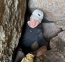
Our expedition was beset early on with equipment snafus.
I see you.
However, we were able to surmount these difficulties and we started walking the rest of the way up the road. The road. Finnback (center) says hi.
Finnback shows itself. Over there - don't you see it? It's next to Horseshoe. Finnback (left) with false summit, Horseshoe (center).
Our nervousness about hiking a mountain at a non-14er TH without a trail to the summit was slightly lessened at the sight of our goal. But not by much - how would we get there?
For now, the road was our path. But there were two ways to go! Decisions decisions... One went to the left and went near the power lines. The other went straight ahead and was less used, but it met up with the one that went left after about 50 yards or so. We chose the path less traveled and it made all the difference for those 50ish yards.
Left or Right. Left or Right... We went right.
We came to some signs of ancient civilizations under the modern powerlines. This area is desolate and I can't see how any humans could live here permanently. The ruins of these ancient settlers filled us with a sense of dread. If they were unable to survive here, then how would we? We're done for!
A little spackling and some napalm this place would make a nice mausoleum.
We kept going along the old road. One foot in front of the other. Not only was the environment unfriendly, but there was also a formidable gate blocking our quest (Not to mention a descent in the middle of our ascent... What's up with that?).
Where does that hill go? It goes up.
We didn't want to run afoul of the law by trespassing. Who knows what would happen - crazy miners might harass us with firearms, the fuzz might come out and take us in, they might even garnish my wages and I can't have my wages garnishied...
We bypassed the gate to the left and walked through an area of trees.
We made it through the first clump of trees unscathed. We continued walking toward the ridge, glad the Ents had not decided to eat us.
The view ahead caused us to shake. Kate said "We'll never survive." I replied "Nonsense. You're only saying that because no one ever has."
Something must have fallen into one of the classic blunders. A Sicilian was here.
Death awaited us with nasty big pointy teeth...
Into the fire swamp we went. We listened for popping sounds and watched for lightning sand. It was the ROUSes that we were really worried about: Rodents so big they can carry tents away and will eat your gear if you leave it unattended. This day, we passed without any problems.
I lead us into the next area of forest. Who's the more foolish? The fool, or the fool who follows him?
We came upon some animal tracks. What sort of evil beast could these belong to? Manbearpig? Sasquatch? El Diablo que hace trofeos de los hombres? A rabbit with a mean streak a mile wide?
We were worried that we had come close to the Cave of Caerbannog and that our next step would be our last. We move. Five meter spread. No sound.
We cleared the forested area. We heard twigs snapping and grunting, but we couldn't see the cause through all the trees. Horseshoe's dangerous "Horseshoe Glacier" is ahead. We avoided it to the left.
We walked up the slope a bit and we came to the famous "Polar Bear Rock." Local Inuit legends say that the gods rewarded this polar bear for her courage and dedication to her relentless pursuit of protecting her cubs. Everyday she would look out across the land for dangers and protected her cubs with her life. But in her quest to make her cubs safe and well fed, she killed many creatures that were just trying to make their way through the world. The gods honored (cursed?) her by turning her to stone so she could look after her cubs for all time. Sooner or later, the day comes when you can't hide from the things that you've done anymore.
Her view: Not too shabby.
We were getting closer to our goal. Finnback is left of center.
We inadvertently spooked some elk. An old hermit who lived out beyond the Dune Sea once told me that elk are easily startled, but they'll soon be back and in greater numbers. We prayed that the elk were in a good mood if we were still around when they returned.
We reached the remains of the Castle of Aaauuuggghhh. It has seen better days. At least they had the good sense to not build it in a swamp. Thankfully the Rock Biters were not home.
Past the castle ruins, we made our way along the grassy tundra closer and closer to the mighty summit block.
Closer... You lose it here and you're in a world of hurt.
The summit is guarded on one side by some pretty impressive cliffs. The Cliffs of Insanity.
Zoomed. Sheridan, Gemini, and Sherman are in the background.
We had gained the summit! It was an arduous journey. We braved forests, gates, rocky cliffs, glaciers, electrical lines, rough roads, beasts, long grass, and even a mosquito or two. But we prevailed.
And there was much rejoicing.
The view from Finnback's summit of the Peerless Group. Left to right: Sheridan, Gemini, Sherman, White Ridge, and Peerless. The Peerless Group? You're going to find that many of the truths we cling to depend greatly on our own point of view.
The ridge to Finnback's false summit, Horseshoe Mountain. View to Horseshoe. Yeah, it's taller, but if your goal is Finnback, then it's just a false summit...
No this isn't a 14er. It's not even a ranked 13er. It was a nice walk in the mountains. You needn't worry about your 14er checklist. If a checkmark is all that you love, then that's what you'll receive.
Time to start our way down.
The old man was right. The elk returned and there were more of them...
Back in the woods, we came across more signs of civilization. You know, I came this close to buying this place, but then I found out that Hop-along Cassidy killed himself here. Bow and a
Looking back at our route. Finnback is left of center, above the cliffy things.
Heading home. Why did the dinner cross the road?
Not all of these words were mine.
We hope you enjoyed this report.
Now... isn't there a Finnegan Peak somewhere...
Thumbnails for uploaded photos (click to open slideshow):
Enjoyed reading the climb to your namesake! Maybe it doesn't have the amazing scenery of some places, but there's still a lot of beauty there to experience and enjoy. Enjoyed your clever narrative! Cool polar bear rock! Thanks for sharing this!
I didn't think anyone could top the Winter Little Bear to Blanca traverse or the Capitol to Snowmass ridge, but I think this might do it. Gave me shivers. I'll have to pull out my rope and give that glacier a try. Would be good practice for K2.
I didn't think anyone could top the Winter Little Bear to Blanca traverse or the Capitol to Snowmass traverse, but I think this might do it. Gave me shivers. I'll have to pull out my rope and give that glacier a try. Would be good practice for K2.
Good report. Polar bear rock still guarding the slope! Top of FS 150 has a private prop sign so guessing the first 1/2 of this route may be trespassing?? Start from lower down the road and should be fine.
Caution: The information contained in this report may not be accurate and should not be the only resource used in preparation for your climb. Failure to have the necessary experience, physical conditioning, supplies or equipment can result in injury or death. 14ers.com and the author(s) of this report provide no warranties, either express or implied, that the information provided is accurate or reliable. By using the information provided, you agree to indemnify and hold harmless 14ers.com and the report author(s) with respect to any claims and demands against them, including any attorney fees and expenses. Please read the 14ers.com Safety and Disclaimer pages for more information.
Please respect private property: 14ers.com supports the rights of private landowners to determine how and by whom their land will be used. In Colorado, it is your responsibility to determine if land is private and to obtain the appropriate permission before entering the property.


 says hi.")
 with false summit, Horseshoe (center).")


")
 I see you.")
 The road. Finnback (center) says hi.")
 Finnback (left) with false summit, Horseshoe (center).")
 Left or Right. Left or Right... We went right.")
 A little spackling and some napalm this place would make a nice mausoleum.")
 Where does that hill go? It goes up.")
")
")
 A Sicilian was here.")
 Who's the more foolish? The fool, or the fool who follows him?")
 We move. Five meter spread. No sound.")
 Horseshoe's dangerous \"Horseshoe Glacier\" is ahead. We avoided it to the left.")
 Sooner or later, the day comes when you can't hide from the things that you've done anymore.")
 Finnback is left of center.")
 Not too shabby.")
")
 Thankfully the Rock Biters were not home.")
")
 You lose it here and you're in a world of hurt.")
 The Cliffs of Insanity.")
 Sheridan, Gemini, and Sherman are in the background.")
 The Peerless Group? You're going to find that many of the truths we cling to depend greatly on our own point of view.")
")
")
 Finnback is left of center, above the cliffy things.")
 Why did the dinner cross the road?")
 You know, I came this close to buying this place, but then I found out that Hop-along Cassidy killed himself here. Bow and a")
 View to Horseshoe. Yeah, it's taller, but if your goal is Finnback, then it's just a false summit...")