Download Agreement, Release, and Acknowledgement of Risk:
You (the person requesting this file download) fully understand mountain climbing ("Activity") involves risks and dangers of serious bodily injury, including permanent disability, paralysis, and death ("Risks") and you fully accept and assume all such risks and all responsibility for losses, costs, and damages you incur as a result of your participation in this Activity.
You acknowledge that information in the file you have chosen to download may not be accurate and may contain errors. You agree to assume all risks when using this information and agree to release and discharge 14ers.com, 14ers Inc. and the author(s) of such information (collectively, the "Released Parties").
You hereby discharge the Released Parties from all damages, actions, claims and liabilities of any nature, specifically including, but not limited to, damages, actions, claims and liabilities arising from or related to the negligence of the Released Parties. You further agree to indemnify, hold harmless and defend 14ers.com, 14ers Inc. and each of the other Released Parties from and against any loss, damage, liability and expense, including costs and attorney fees, incurred by 14ers.com, 14ers Inc. or any of the other Released Parties as a result of you using information provided on the 14ers.com or 14ers Inc. websites.
You have read this agreement, fully understand its terms and intend it to be a complete and unconditional release of all liability to the greatest extent allowed by law and agree that if any portion of this agreement is held to be invalid the balance, notwithstanding, shall continue in full force and effect.
By clicking "OK" you agree to these terms. If you DO NOT agree, click "Cancel"...
Note: as an amateur, I write these from an amateur's perspective (and I usually prefer to let the pictures do the talking). My goal is to add an "outsider's perspective" to supplement the real route descriptions - please don't use this as an indication of what to do or where to go. I sure as heck don't know what I'm doing.
A group of us decided to rent a house over the Fourth of July week, and tackle some of the more interesting San Juan fourteeners - the San Juans present a major hole in my fourteeners resume because they can't be easily driven to in a single day from Denver (first world problems).
Anyhow, we arrived on Saturday afternoon with intents to climb El Diente on Monday morning. Most people don't realize that "El Diente" is Spanish for pasta slightly undercooked. The weather forecast looked slightly better for Sunday, so we decided to call it a night early and head out.
We left the house at 3:45 sharp, and arrived at the Kilpacker Basin trailhead just around 5 a.m. By this point, I realized that my Camelbak bladder had leaked on the drive over, and I was down to about a quarter-bladder, a quart of Gatorade, and the rest of the Gatorade that I had been hydrating with on the way to the trailhead.
At 5:10am, we started up the hill.
The few few miles on this hike are nice and mellow (on the way up) as we work our way around to get into the Kilpacker Basin proper. Over the first two miles, we only gained 200 vertical feet (but we gained it multiple times). Some of the creek crossings are fun, but nothing unmanagable.
After a few miles, we get the iconic El Diente image.
El Diente isn't happy with us invading his turf.
The waterfalls in this valley are as nice as I'd heard - it was fun to see the creek disappear under talus for several hundred feet and then reappear with a burst of waterfally goodness.
The hike up to the upper basin is chock-full of talus and scree; in some places, loose dirt was a welcome sight. So up we went!
The San Juan mountains guard themselves well.
As for El Diente, it has a sign on it, and the sign is "beware". At this point, the scree/talus is getting more and more obnoxious, and at this point, I'm missing a good RMNP well-packed trail.
We work our way into the upper basin, directly south of the main summit, and it's pretty easy to figure out when to work up higher. If I were a supervillain, this would be where I'd place my hideout (or perhaps to escape from the zombies!).
And now it's time to go up, up, up!
Here we are at the "business end" of the mountain. Vigilance is required here - every step could dislodge something.
Helmets are on now! We were vaguely tracking a young lady whose intent was to do the traverse, and she was headed straight up to the headwall. In the end, we probably weren't paying as much attention as we should have been, and we climbed too high before we realized that we hadn't turned soon enough.
Hopefully the lady made it back to the car okay - she ended up following us up the gully to some degree (but we lost her after awhile). Her car was still next to ours at the trailhead, so she must have pressed onwards.
And so, we started our journey across the loose gray rock and talus, back to the so-called trail:
Back on track, a look at the remaining mountain. Two gullies to ascend at this point, to get to the saddle. Good time for Run D.M.C.'s "King of Rock".
Into the first gully, and up, up, up! Those of us who were waiting for the "real climb" to start aren't disappointed.
In terms of difficulty, El Diente seemed like Longs Peak, if everything from Chasm Junction to the summit were covered in two feet of loose rock. There was a distinct smell on this part of the trip, and I believe that it was the smell of friction from the rockfalls throughout the valley.
Working our way across the rocks:
Back into the second gully, and this is about where we start playing "Phil Collins or Genesis?" and other fun hike games. And now more up, up, up:
If enough people ascend this route, El Diente will soon have enough prominence to be a "real" fourteener (it sure felt like a real fourteener to us). One of the cool chimneys in the upper gully - lots of loose rock still.
Nearing the summit, a little Snefhornpahgre:
And over to Wilson Peak, with a heads up for our goal later this week:
The traverse route to Mount Wilson:
No thank you. And the Kilpacker Basin:
We have to get all the way back down there? Sigh.
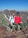
Finally on the summit - the summit block is about half the size of a good couch. "Official" summit photo. This is my 25th (unique) fourteener, Eric's 28th, and Kiersten's seventh.
Some have asked if my face is white because I just applied sunscreen, or because I'm scared to death. It's not necessarily an "either/or" answer.
I also found out at the summit that I wasn't really out of water - I had been carrying an extra full Gatorade! Hallelujah!
This was the first summit I can remember where I wasn't excited to be there - I was just worried about how to get down. Would we miss a turn? Would a slab of rock fall off in our hands?
The first step in going down? Going down.
Working our way between gullies, Kiersten gets a handful of crack:
Over and up! God bless friction and gravity.
Knees are really starting to bug me at this point.
Continuing to work our way across the gullies:
If you don't make the traverse proper between El Diente and Mount Wilson, you have to deal with this:
All of a sudden, the traverse seems a whole lot more reasonable.
Still coming down, as the most dangerous dangers start to abate:
Of course, a broken leg would still be pretty bad on this stuff, this far in the basin, and everything moved with every step.
Talus, talus, everywhere, but not a slab to stick. I'm going to have nightmares about this photo for years:
As is usually the case in the San Juans, "20% chance of rain after 2pm" usually turns into thunderstorm worries around noon. Finally to treeline.
And the lower waterfall - we lost the trail a bit here, and cliffed out at this great view:
We get back to the flatness of the meadow as El Diente bids us farewell:
At this point, we've got about three miles of rolling hills back to the car. CFI must have been out here on Sunday during the day, because someone installed about three times as many "rolling hills" on the trail as there were when we left that morning.
5:30 to summit, 9:25 in total. Five of us attempted, and three of us summited. Anyhow, it tested our limits - well, it certainly tested my limits. Glad we did it, and glad that it's done. I'll probably do it again someday.
If you want solitude, this is the place to be - on the entire 9:25 trip, we saw: the lady who was going to traverse, two seventy-somethings going to the lower waterfall (and who couldn't figure out why I was lying flat on my back on the trail. "Wait - you didn't go all the way to the *upper* waterfall, did you?"), and two gentlemen traversing above us as we ascended the upper gully (we never crossed paths with them). Five people in total (two whom we never came near, just saw) in a 9:25 car-to-car trip. Not too shabby.
Breaking down the hike into segments: easy / tedious / scary / summit / scary / tedious / tedious. And as I write this up the next afternoon, my main thought is that I'm surprised that Carmex doesn't have sunblock in it, and is this why my lips are so darned chapped?
My GPS Tracks on Google Maps (made from a .GPX file upload):
I enjoyed your perspective, as mine is usually similar on those kinds of climbs. This one is on next year's short list so this report is very helpful, both confidence and beta wise. But this year's trip (in a few weeks) will be to the Crestones, where like you, I'm sure I'll be nervous and thrilled at the same time.
Thanks for posting your story, very enjoyable read! You missed out on the fun of camping by the ”Loose Tooth” and listening to it fall apart all night.
I highly recommend going back for Wilson Peak, a much more enjoyable climb!
Wish, looking forward to your Crestone TRs - ever since the time I was hiking Raspberry Gulch while you were TRing it, I've enjoyed your viewpoint on things.
Rainier, Wilson's definitely on the list! Wish it would stop raining a bit, though.
Caution: The information contained in this report may not be accurate and should not be the only resource used in preparation for your climb. Failure to have the necessary experience, physical conditioning, supplies or equipment can result in injury or death. 14ers.com and the author(s) of this report provide no warranties, either express or implied, that the information provided is accurate or reliable. By using the information provided, you agree to indemnify and hold harmless 14ers.com and the report author(s) with respect to any claims and demands against them, including any attorney fees and expenses. Please read the 14ers.com Safety and Disclaimer pages for more information.
Please respect private property: 14ers.com supports the rights of private landowners to determine how and by whom their land will be used. In Colorado, it is your responsibility to determine if land is private and to obtain the appropriate permission before entering the property.


")
")
")
")
")
")
")
")
")
")
")
")
")
")
")
")
")
")
")
")
")
")
")
")
")
")
")
")
")
")