Download Agreement, Release, and Acknowledgement of Risk:
You (the person requesting this file download) fully understand mountain climbing ("Activity") involves risks and dangers of serious bodily injury, including permanent disability, paralysis, and death ("Risks") and you fully accept and assume all such risks and all responsibility for losses, costs, and damages you incur as a result of your participation in this Activity.
You acknowledge that information in the file you have chosen to download may not be accurate and may contain errors. You agree to assume all risks when using this information and agree to release and discharge 14ers.com, 14ers Inc. and the author(s) of such information (collectively, the "Released Parties").
You hereby discharge the Released Parties from all damages, actions, claims and liabilities of any nature, specifically including, but not limited to, damages, actions, claims and liabilities arising from or related to the negligence of the Released Parties. You further agree to indemnify, hold harmless and defend 14ers.com, 14ers Inc. and each of the other Released Parties from and against any loss, damage, liability and expense, including costs and attorney fees, incurred by 14ers.com, 14ers Inc. or any of the other Released Parties as a result of you using information provided on the 14ers.com or 14ers Inc. websites.
You have read this agreement, fully understand its terms and intend it to be a complete and unconditional release of all liability to the greatest extent allowed by law and agree that if any portion of this agreement is held to be invalid the balance, notwithstanding, shall continue in full force and effect.
By clicking "OK" you agree to these terms. If you DO NOT agree, click "Cancel"...
Peaks Climbed:
Mt. Aeolus (14,083 feet, 4293 meters, clean prominence 666 m)
North Aeolus (14,039 feet, 4279 meters, unranked due to lack of prominence)
Sunlight Peak (14,059 feet, 4285 meters)
Windom Peak (14,082 feet, 4292 meters)
Jupiter Mountain (13,830 feet, 4215 meters)
Note, there are resources that put Windom's elevation above Eolus's, I hope this is the most recent data..
Literature: 14ers.com, 14000 FEET (Walter R. Borneman), Colorado's Fourteeners and Colorado's thirteeners (Gerry Roach), PM from FireOnTheMountain
Gear: Climbing Shoes for Sunlight summit block. Other than that, nothing special.
Stats: Hiked about 42 miles, gained about 16000 feet.
I've hiked fifty 13ers since the beginning of the year and only two 14ers (Pikes and Sherman, both repeats). It is because I only have difficult 14ers left and I waited for the snow to melt off of them. The 4th of July weekend seemed to be an ideal time to get back onto a horse back and climb some of those remining beasts. During almost every trip I have done this year, I had to deal with incredibly awful winds. I don't know if it's a common winter/spring weather or if it is this weird year, but gusty winds of maybe 40-50 mph was the most common partner to hike/climb with.
While thinking about the 4th of July weekend, I opened my beloved book 14000 FEET and went across the chapter about the Needles. And there I found this statement: "From the slopes of Uncompahgre in 1874, Franklin Rhoda observed a group of very scraggy mountains, about which the clouds were continuously circling, as if it was their home.... Later from Mount Sneffels, Rhoda remained dully impressed: "We have never yet seen the group from any station (and we have viewed it from all sides)....The storm clouds seem to hover around them before starting their meandering way"...Rhoda's assessment that the range was a "manufactory of storms" gave rise to naming it's highest peak Aeolus, for the Greek god of the winds...
Awesome, I keep struggling with strong winds on my trips and we have the GOD of the WINDS right here in Colorado! So why not to go and ask him for less wind for the rest of the season? That was a great plan!
I started a thread here, if anybody else is going the same direction and got a PM from 49ersRule that he is going the same peaks with a group of other people, so I asked if I can join them and they were OK with that. We didn't plan any meeting just stated which peak which day and that we will probably find each other on the way up.
There are several options to get to Chicago Basin, none of them is easy. The shortest is to take the train from Durango to Needleton and than hike 6 miles, gain 3000 feet of elevation. Well. Too much of planning. I hate to call somewhere and reserve the tickets. What if I buy them and the weather is bad? Moreover, they cost like 100 $ and thats way too much for a cheapa$$ like me. Wait a sec. ........ No, that's not what I wanted to write here! Not at all. I ment, I am a super cool hard core mountaineerer, I am in shape and 7 more miles and maybe 1500 feet of elevation gain is no big deal for me, right? After all, the train is for kids and sissies.... Yeah, that was what I ment... I remembered, a while ago, a good mountaineerer FireOnTheMountain told me he went to Chicago Basin from Purgatory Creek Trailhead and it was super easy. He made it before the train crew, so he could choose any tent spot he needed. Great. So I PM'd him and got a really nice explanation how to get there.
Day 1: Getting in, about 13 miles, 4500 feet of elevation to gain.
Purgatory Creek Trailhead: From the town of Ouray, you go 44 miles south and that gets you to the Purgatory Ski resort (now known as the Durango). There is a road EXACTLY opposite to the main gate of the resort with a huge sign on it. Take a left off of 550 and drive down the road staying left until you reach the little lake about 0.75 miles from the turnoff. So I drove there from Boulder on Friday and slept in my car overnight, woke up at 6 am, packed the backpack and started at 7. The trail is well signed. Follow it down about a mile to the valley of Cascade Creek. The area is beautiful.
Trail around Cascade Creek.
Despite the unfathomable beauty of the area, very soon, I started to feel the heavy backpack. It might had 60-70 pounds, all of the camping gear in it, water for today, some hard boilded eggs, nobody to share the weight with. Also, inappropriate (heavy) stuff and food. I soon realized that I need to take breaks pretty often. The trail mostly follows the creek, for maybe 3 miles, however, when it gets closer to the Animas River it upclimbes the valley wall because the gorge is too narrow at the bottom. After a little over 2 hours, I crossed the bridge across the Animas River and took a short nap.
Bridge across the Animas River.
And then there was 4 miles around the Animas River. Again, really beautiful place. All the way there is well maintained trail. The only thing to deal with was the backpack. Purgatory is probably the most accurate trailhead name for what I got into. I just got into a real Purgatory - the place where the soul is being cleaned off its sins before it can enter the heaven. I definately felt I was being cleaned off my sinn of greed and pride and started to think if I shouldn't actually had bought the train ticket...Well, too late to think. So I stopped more often, ate snickers, drunk a lot of water and continued.
Trail around Animas River (on the way out).
It was about 4 hours hike around the river. Several trains (or two?) passed by and I finally got to the place where my trail merged with the trail from Needleton Station at 1.15 pm. And then there was almost 6 more miles and 3000 feet to gain. Slowly and steadily, with a lot of short stops and several longer. At 6.30 pm, I got to the basin and hiked to the higher part, found a place to build a tent, rested, set up my home for following days.
Finally in the basin.
View of the mountains in Chicago Basin
The views are spectacular. The area is made of granite (exception from mostly volcanic rock in the majority of San Juans) and rock were glowing in low sunshine. I ate, set up my alarm clock for 5 am and hoped I will recover for the morning hike up Aeolus.
Day 2: Mt. Aeolus and North Aeolus. About 5 miles, 3000 feet to gain.
Mt. Aeolus.
There is trail all the way up, the turn to Twin Lakes is well labeled, just after that, it gets steeper and I put off my pants and put on shorts. Soon, around the headwall, I met with a group of people and since I said hi, I was questioned if I am on 14ers.com, I said Yes, I am Milan and it turned out, I was talking to Dave, 49ersRule and so I joined him and he introduced me to the rest of the group. View of Aeolus were just amazing and I started to worry a bit if it is not too difficult for me. But as I am used to, I don't just fear before I am actually there. Often, the mountain looks much more difficult that it really is.
Mt. Aeolus.
I realized, that the group (Paula, Sunny1, Fishdude, HighPilgrim, HighPilgrim's brother, and 49ersRule) has a nice pace, just a little slower than I am used to but still well within my range of comfort. I actually was happy for that, because I was kind of sore after the Purgatory...These people also were more experienced than I am, so I had a lots of question about the mountains that are on my list to do. I hope they saw it similar way, I really liked to hike with them. We soon got to the Ramp and then to Catwalk.
Mt. Aeolus.
On the ramp.
Catwalk.
The infamous Catwalk, I used to be scared just looking at the pictures of people on it. But as many TR before stated, its really not a big deal. There is exposure, for sure, but the ridge is pretty wide and offers multiple holds, stands, variations for safe feelings. And then the East Face. It sure is impressive. And scary. Exposed. But overall, not too difficult climbing. And there I saw the biggest advantage of going in a group. The decissions were made by a concensus, Dave was scouting out the terrain and gave the rest of us info how it looks over the corner, people gave each other advice how to pass obstacles, Sunny1 encouraged me when I got scared. It just worked perfectly and soon we were on the ridge and on the summit.
On the Aeolus's face.
Climbing the East Face.
Sunny1 is climbing up.
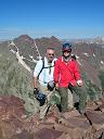
Our Group on the summit. Hello God of the WINDS!
Sunlight and Windom, plan for Monday.
The downclimb wasn't any worse than the climb up. Its probably because it's just class 3. I had bad feelings downclimb class 4 and up or more exposed areas. And we crossed the Catwalk again and this time it was even easier. And we did the quick climb up the North Aeolus, probably the easiest slab climbing you can imagine. Lots of holds (not too typical for granite) and easy, not exposed.
Climbing down, the picture shows a bit of exposure and steepness.
North Aeolus.
On the summit of North Aeolus.
And here picture from the Twin Lakes, where we took a little break and some pictures of Monday Advenures. For Monday, Me, Paula and Dave went for Sunlight and Windom but the rest of the group who already did them went to Jupiter Mountain. In the evening, I visited my new friends at their campsites and begged some cold water to drink (I was boiling my own to desinfect it, so all what I had was warm at the time). We had fun time and talked mostly about 14ers.
Sunlight from Twin Lakes.
Day 3: Sunlight and Windom, about 7 miles and 4000 feet to gain.
Monday, up on the slope of Sunlight.
Up the Sunlight.
Impressive Jagged.
Windom, our next target.
The route to Sunlight is well described here, red gully is pretty steep but not a big deal and once you reach the first notch, the description says here the class 3 scramble starts. Not necessarily. It is there, when you go over the rock on the side of the ridge. But there is option to lower yourself farther to the left, all the way under the cliffs and its pretty easy class 2 boulder - hopping, talus. You can bypass all of the difficult section and at the end there is a gully, with some dirt in it (still OK class 2) that goes up onto a flat area with the first window. So untill there, easy class 2 (better than the red gully). After that, there is a short scramble to the second window which I'd say is class 3. Its on the picture #24 and there is no exposure. So to the summit register flat area, the mountain is pretty easy. Thats about to change. It looks like everybody is choosing a different approach to the summit block and many people even don't go for. My advice is, go, look at it, make a decission, find your comfort, try it. Don't worry if you don't feel for it. It's scarry. I took my climbing shoes (and kept coarsing them all 13 miles from Purgatory) and I was happy for additional friction. I used Daves advice and climbed the crack in the first boulder. Its easy and not exposed. Then I though of how to pass from the first to the second boulder. There is maybe 3 feet of room between and the 2nd rock is much higher. If you fall there, its not the big chasm of 1500 or so feet, its more like 15, so you probably don't die but there would be a broken something. So careful there. The rock is typical granit, so don't count on any sort of handhold, its simply not there, everything is rounded like big boobs but rough enough, so you need to use FRICTION, hug the mountain. Thats what I did and I was on the 2nd boulder. The 3rd step is easier. But the summit is VERY exposed. And since I am scared of exposure, I climbed it, but I didn't sit down, nor did I stand up. I just stayed shamefully on my stomach. But at least, the mass of my body made it over the summit point.
On the summit of Sunlight.
Some people jump from the 2nd to the 1st block. No way I'd go for. I can't keep ballance on a sidewalk, so that was not an option for me. To just lower myself, put one feet on the opposite rock and second on the frst one and chimney it was not an option either. Its too high. So what I did. I put one foot and one hand on the opposite rock and jumped on a boulder that is even much lover just inside the crevasse. And it worked. Down and safe, had time to perform my sowing machine reflex...Downclimbing Sunlight, I took more pictures.
Arrow and Vestal.
Some class 3 scramble down the Sunlight, to the 1st. window.
We descended to the saddle between Sunlight and Windom, there is an obvious path from one peak to another. We just needed to stay off the snow. This time it was easily passable. However, the weather looked worse and we heard a thunder in some distance. We decided to continue to Windom watch the clouds very carefully and in case it gets closer, go back. It was not the smartest decision I've ever done, we rolled the dice (as David likes to say) but this time we won. The storm stayed asside and lightning was somewhere around the Jagged Mountain, behind Sunlight..We pretty much run up and down, so I only have one picture from the summit and you can see the unfriendly cloud there (this one was not storming yet nor raining.
Summited Windom Peak.
We made it up the summit along with another maybe 7 people, Dave was there first and he was waiting for Paula there a bit but I was too scared and only took a picture and immediatelly left for lower lands. The hailstorm came when I was down at the Twin Lakes. Fortunately, there was not a lot of thunders/lightening in this storm...We made it down to the camp sites, it stopped raining, I made myself coffee, food, ate and started to relax in the tent when it started to rain cats and dogs and didn't stop until like 8 pm. It was sunny after then. I went to visit my friends again but there was zero life in their camp, so I didn't want to wake them up and went back to my place.
Day 4: Jupiter mountain and most of the way out. Maybe 14 miles and 3000 feet to gain. Day 5 getting out, about 3 miles and 1500 feet to gain.
On Tuesday, I went to Jupiter Mountain.
Starting Jupiter on Tuesday.
The route is pretty annoying steep grassy slope. I didn't like it. It took forever to reach the ridge and the false summit. Then there was the scramble to the real summit. Go left, there is sort of ledges, the only thing is, rock is loose and unstable there. I happen to knock down several surprisingly large blocks of granite that looked OK but they were not. So be careful there.
Summit of Jupiter.
Windom is also a rugged peak!
I got back to my camp at 11, packed up and started my way down at maybe 12.30. I got to the bridge over Animas River (at the confluence with Cascade Creek) at 8 pm, built a tent, cooked, went sleep. Woke up in the morning, continued the impressive gorge of Cascade Creek back to my car. I got there at noonish. On the way, I met the rangers with a huge saw and mules and other equipment and talked to them. They are there to maintain the trails, I talked to them and told them they do a great job with that and that we are very happy for what they are doing.
Thumbnails for uploaded photos (click to open slideshow):
Dave, I'd love to hike with you again. Staropramen was actually one of my suggestions but probably didn't get the pronounciation ..
Papillon, where was your camp? Down in the forest next to Dave and the group? If I knew I am in the same basin as you, I'd stop by and say hi. I used more than one trip reports of yours to guide myself on 13ers this year.
We were on the other side of the giant rock - between their camp and the trail. I didn't realize it until we ran into highpilgrim and sunny1 up on Jupiter. I think we all got out just in time. The rain was pretty heavy on Wednesday late morning.
Dave, I'm just teasing you. I was amazed that the coyote urine worked. Next time though, I'll sprinkle it more than ten feet from our tent.
I think highpilgrim's camp could be the best in the basin, especially with the creek access. Does anyone know if his ”animas stash” survived? Mine did... 8)
Milan, congrats on your successful climbs!
It was fun to meet you.
Great report - you covered ALOT of ground. I love the Purgatory references and thoughts.
Papillon, stuff in the Animas thrives! We enjoyed it while waiting for the train (and great to meet you and Sarah on Jupiter).
It takes waaaaaaay more than coyote urine to keep the 2-legged beasts away!
9ers is a wandering mess.
Good times!
Milan, thanks for posting this! I hope Aeolus grants your wish!
I have to say that meeting with such a great group of people was just awesome for me. I've been mostly soloing this year and this was a completely different thing. In a nice way. And I'd love to hike with you sometimes again.
Two weeks ago I completed the same itinerary, but I cheated. We wanted to bring our dog, so I hiked in from Purgatory with the dog while my wife rode the train with our big packs! Even with cheating, I was hurting on that big day 1...kudos to you for enduring and having such a successful trip!
Hey, you're an animal! Can't believe that you still had the motivation to do Jupiter on Tuesday after the long hike in, and the 2 days that you hiked with us.
Had a great time hiking with you! Let's do it again, sometime. Also, found out what beer I liked so much in the Czech Republic: http://en.wikipedia.org/wiki/Staropramen
Sorry about the wanderings. Just trying to herd the goats away from our camp. HighPilgrim was threatening harm against them, and I just couldn't have that.
Caution: The information contained in this report may not be accurate and should not be the only resource used in preparation for your climb. Failure to have the necessary experience, physical conditioning, supplies or equipment can result in injury or death. 14ers.com and the author(s) of this report provide no warranties, either express or implied, that the information provided is accurate or reliable. By using the information provided, you agree to indemnify and hold harmless 14ers.com and the report author(s) with respect to any claims and demands against them, including any attorney fees and expenses. Please read the 14ers.com Safety and Disclaimer pages for more information.
Please respect private property: 14ers.com supports the rights of private landowners to determine how and by whom their land will be used. In Colorado, it is your responsibility to determine if land is private and to obtain the appropriate permission before entering the property.


.")


 Bridge across the Animas River.")
 Finally in the basin.")
 View of the mountains in Chicago Basin")
 Mt. Aeolus.")
 Mt. Aeolus.")
 Mt. Aeolus.")
 On the ramp.")
 Catwalk.")
 On the Aeolus's face.")
 Climbing the East Face.")
 Sunny1 is climbing up.")
 Our Group on the summit. Hello God of the WINDS!")
 Sunlight and Windom, plan for Monday.")
 Climbing down, the picture shows a bit of exposure and steepness.")
 North Aeolus.")
 On the summit of North Aeolus.")
 Sunlight from Twin Lakes.")
 Monday, up on the slope of Sunlight.")
 Up the Sunlight.")
 Impressive Jagged.")
 Windom, our next target.")
 On the summit of Sunlight.")
 Arrow and Vestal.")
 Some class 3 scramble down the Sunlight, to the 1st. window.")
 Summited Windom Peak.")
 Starting Jupiter on Tuesday.")
 Summit of Jupiter.")
 Windom is also a rugged peak!")
 Trail around Animas River (on the way out).")
 Trail around Cascade Creek.")