Download Agreement, Release, and Acknowledgement of Risk:
You (the person requesting this file download) fully understand mountain climbing ("Activity") involves risks and dangers of serious bodily injury, including permanent disability, paralysis, and death ("Risks") and you fully accept and assume all such risks and all responsibility for losses, costs, and damages you incur as a result of your participation in this Activity.
You acknowledge that information in the file you have chosen to download may not be accurate and may contain errors. You agree to assume all risks when using this information and agree to release and discharge 14ers.com, 14ers Inc. and the author(s) of such information (collectively, the "Released Parties").
You hereby discharge the Released Parties from all damages, actions, claims and liabilities of any nature, specifically including, but not limited to, damages, actions, claims and liabilities arising from or related to the negligence of the Released Parties. You further agree to indemnify, hold harmless and defend 14ers.com, 14ers Inc. and each of the other Released Parties from and against any loss, damage, liability and expense, including costs and attorney fees, incurred by 14ers.com, 14ers Inc. or any of the other Released Parties as a result of you using information provided on the 14ers.com or 14ers Inc. websites.
You have read this agreement, fully understand its terms and intend it to be a complete and unconditional release of all liability to the greatest extent allowed by law and agree that if any portion of this agreement is held to be invalid the balance, notwithstanding, shall continue in full force and effect.
By clicking "OK" you agree to these terms. If you DO NOT agree, click "Cancel"...
July 4th, 2012
Route: up - standard route via Halfmoon pass, down - Halo Ridge
Stats: ~13 miles RT, 5,400 elevation gain, 10.25 hours
Mt. Of the Holy Cross was one of the "easiest" 14ers I had left and I was considering "saving" it for a finisher. However, a few considerations made me change my mind.
1) At ~12 miles & 5'600 elevation gain (standard route), it is not an easy hike (and I was thinking of inviting some friends who are more of casual hikers)
2) Weather forecast was looking so bad for the Wilsons group that canceling that trip and making an attempt on Holy Cross as a day trip on July 4th sounded like a reasonable idea.
To be precise, the forecast for the Holy Cross did not look stellar either- "70 percent chance of precipitation after 9am", but Minturn is a quite a bit shorter drive than Telluride. So on Tuesday, July 3rd I left Denver after work, half-expecting to be back home on the 4th after an attempt on Holy Cross. I made it to the trailhead around 10pm after ~3 hours of driving and promptly hit the sack for the 4am wake-up call. Morning came and I started on the standard (Halfmoon) trail at 5am. Although my preferred route was Halo Ridge, I decided to go up the standard route as fast as I could and see what the weather would look like.
Intense colors of a sunrise are from raging wildfires
First look at Holy Cross from Halfmoon pass
A very long ridge to get up the shoulder
MHC rears its head
Finally the remaining route becomes visible
What's left of Angelica's couloir
Summit of Mt. of the Holy Cross - it is America's Birthday!
I got to the summit around 9.10am and was really surprised to see that the weather still looked good - the thick smoke from the wildfires was obstructing the views, but there were no rain clouds to speak of.
After meeting and chatting briefly with Chicago Transplant (a 14er.com representative disguised as a Forest Service volunteer that morning), off to the Halo Ridge I went. One of my friends gave me the "Colorado 14er Disasters" book as a gift when I first started hiking 14ers two years ago (probably hoping that accounts of the deadly accidents would deter me from hiking the peaks), and the story of Michelle Vanek really stood out to me at the time. On my way to the Holy Cross Ridge, I could not help but think about Michelle - this is not an easy traverse and was probably very difficult for Michelle in her extremely fatigued state.
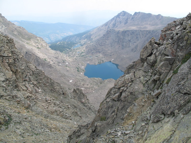
The Bowl of Tears
Notch shelter across the ridge
Holy Cross Ridge
Tuhare lakes
I made it to the Holy Cross Ridge around 10am, noticed some familiar names on the register and continued. I really enjoyed going down the Halo Ridge and just want to put my vote for this route as a descent route vs. going up. True, there are several "bumps" along the ridge that need to be climbed over or around, but they are going in the right general direction - lower, and the Notch shelter is a welcome beacon, as it is getting closer & closer as you go along. There is almost a two-mile stretch of an "easy" ridge walking, which is good for morale. As I looked back, the higher "bumps" on the ridge (HCR and M.H.C.) looked particularly intimidating, as I knew how much work they involved.
Some easy hiking along the ridge
Bowl of Tears lake from the ridge
Remaining route to the Notch shelter
Are you afraid of spiders? No worries, they are quite small
Notch shelter is getting yet closer
Full view of M. of Holy Cross - not much left of the couloir
After about 3.5 hours on the ridge, I made it to the Notch shelter around 1pm (it was cloudy by then but still no rain).
M.H.C. as seen from the shelter
Last look
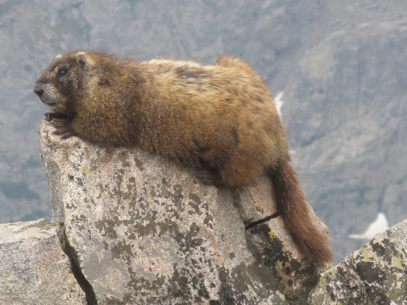
A rather large marmot
Notch Mountain Trail
Wildflowers are in full bloom
Coasting along a very nice Fall Creek trail, I reached the car just after 3pm. Despite the ominous forecast, the weather held really nicely, so that got me thinking - what if the Wilsons weather forecast could turn out to be as favorable? What if?
... and super Nat! Well done! Nice that you had the opportunity to meet Mike. He's a legend in his own right. In the past I've contacted him several times regarding this loop. Have yet to meet him in person however, but have gotten to know him via email. This is still one of my all-time favorites loops! Very nice sunrise shot!
SnowAlien, good information. I’ll be shooting for the loop (with Halo first)on 8/7/15. I do appreciate your write–up!
Caution: The information contained in this report may not be accurate and should not be the only resource used in preparation for your climb. Failure to have the necessary experience, physical conditioning, supplies or equipment can result in injury or death. 14ers.com and the author(s) of this report provide no warranties, either express or implied, that the information provided is accurate or reliable. By using the information provided, you agree to indemnify and hold harmless 14ers.com and the report author(s) with respect to any claims and demands against them, including any attorney fees and expenses. Please read the 14ers.com Safety and Disclaimer pages for more information.
Please respect private property: 14ers.com supports the rights of private landowners to determine how and by whom their land will be used. In Colorado, it is your responsibility to determine if land is private and to obtain the appropriate permission before entering the property.