Download Agreement, Release, and Acknowledgement of Risk:
You (the person requesting this file download) fully understand mountain climbing ("Activity") involves risks and dangers of serious bodily injury, including permanent disability, paralysis, and death ("Risks") and you fully accept and assume all such risks and all responsibility for losses, costs, and damages you incur as a result of your participation in this Activity.
You acknowledge that information in the file you have chosen to download may not be accurate and may contain errors. You agree to assume all risks when using this information and agree to release and discharge 14ers.com, 14ers Inc. and the author(s) of such information (collectively, the "Released Parties").
You hereby discharge the Released Parties from all damages, actions, claims and liabilities of any nature, specifically including, but not limited to, damages, actions, claims and liabilities arising from or related to the negligence of the Released Parties. You further agree to indemnify, hold harmless and defend 14ers.com, 14ers Inc. and each of the other Released Parties from and against any loss, damage, liability and expense, including costs and attorney fees, incurred by 14ers.com, 14ers Inc. or any of the other Released Parties as a result of you using information provided on the 14ers.com or 14ers Inc. websites.
You have read this agreement, fully understand its terms and intend it to be a complete and unconditional release of all liability to the greatest extent allowed by law and agree that if any portion of this agreement is held to be invalid the balance, notwithstanding, shall continue in full force and effect.
By clicking "OK" you agree to these terms. If you DO NOT agree, click "Cancel"...
Last Wednesday, the world's crappiest forecast put to rest a long-planned trip to a Colorado wonderland, Ice Lake Basin. I was pumped to revisit Vermilion Peak, hit the classic scrambles of US Grant/V4 and Golden Horn/Pilot Knob, as well as fill my memory card with flower pics and go for a chilly dip in Island Lake. When it became apparent that driving to Silverton from Denver with a 60% chance of sitting in our tents all day wasn't exactly a winning bet, it was time to look elsewhere. Several folks headed to the Gores, but I flashed back to that initial slog leading to Pitkin Lake, and decided to look elsewhere. The Gores will always be there. Dave Cooper's Colorado Scrambles book has been quietly sitting out on our coffee table for six weeks. I picked it up and immediately found direction much closer to home than Silverton, with a slightly better forecast. What do we have to lose?
I pitched a Music Pass run to Tom (Tommyboy360), and he liked the idea even more than I did.
What followed was a weekend punctuated by great/lucky timing, solid and exposed scrambling, and memorable pre-climb and post-climb feasts. Here we go...
We left Denver planning to pick up some beers and Jimmy John's in the Springs en route to Westcliffe. After grabbing some hoppy monsters, we made a U-turn and saw something that blew our minds: A Jimmy John's with a drive through. We must live a sheltered life in Denver, as I've never seen one of these before. Can you say faster than fast? With all the time we saved, Tom persuaded me to stop in at Trinity Brewing over on Garden of the Gods Blvd. Usually, at 5pm on a Friday, the place is overflowing with people, and I fully expected to stand around and hope for a seat. We got the last two spots at the bar, ordered up some "Slap Your Mammy," and chowed down on some of their legendary Mak N Bacon, something that came back to haunt us later on...
The cruise down CO 115 and 69 to Westcliffe went smoothly as we sped by the human rights abomination in Florence, passed some RVs near Wetmore, and charged up the Music Pass road to the TH, arriving just past dusk.
I slept well, dreaming of airy scrambles to come.
Day 1: Bringing the Funk to Tijeras
7.38 miles and ~3500' gain (for me)
Optional theme music brought to you by Parliament.
We topped off our packs after sleeping in a little late, and hit the trail for Music Pass. Heading up the trail with the shoulder of Marble Mountain at right
This trail is used by both horses and hikers, making for a wide, easily trodden path up the 800' to the Sange de Cristo Wilderness Boundary, where the views open up to preview the amazing scenery and beautiful peaks ahead. Tom looks out toward Music Mtn (L) and Milwaukee Peak
After the pass at 11,380ft, there's a lovely 490' drop down to the Sand Creek valley. It was already becoming apparent that the Mak N Bacon we'd both eaten the night before has some, well, funky stuff in the mix. Bootsy Collins only dreams of funk like this. Proper trail manners in cases like this dictate hiking a good distance apart, or letting the other guy take the lead when necessary. We took turns setting the pace and falling back. We passed through sunflower-studded meadows to the turnoff for Lower Sand Creek Lake (LSCL), where we dropped our packs, set up my tent, hung up our extra food, and beat feet up the trail toward LSCL. After our short rest, the 400' climb went faster than anyone can deliver a sub, we reached the shore. This is the kind of view you can expect Tijeras to deliver as it towers above.
With the summit 2200' above and George Clinton echoing in my head, I was ready to turn this mother out. A trail leads toward the north side of the lake, and ends here: See those willows at the bottom? Yeah, there's more to come
Our route took us between the two rock outcroppings, ostensibly into a forest. Yes, there were some trees, but the real fun came in the willows. You can see me in there, somewhere. Good Times! (Photo by Tom)
After a thankfully brief session with the willows, we popped out here, with both the initial cliff ringing Tijeras' base and the summit in view.
We headed up through some flowers to a bench...
...and stopped to get our bearings vis a vis the two gullies mentioned by Cooper, Helmut, and K. Baker that afford access to Tijeras' higher reaches. Apparently, our bushwhack put us to the south of the usual ascent route, and we didn't see the northernmost gully, listed as easier by Cooper, until our descent. This shot, taken on Sunday, shows both gullies, each of which slopes upward to the left in this shot. The first option can be seen directly above the tree in the middle foreground of the photo. It's shorter than the second gully, near the right edge of the picture, going upward from the top of a large talus pile. Photo by Tom's iPhone
Since we found ourselves next to the first/harder gully and it looked reasonable, it was time to get our scramble on. There was plenty of water on the right side, but we found our way up without too much fuss. Here goes Tom:
I followed, and we dodged slick, wet spots to find a rappel anchor. I guess when there's ice in here you might use this to get down? Someone around here might have that answer...
At the top of the gully, a group of Bighorns was lounging around... What are you looking at?
...but our eyes were focused on the route ahead. Why? Clouds were beginning to build, in typical Sangre style, to the south and east, but appeared to be heading our way. There was no time for loafing. Rather than take the class 2+ standard route that gains the ridge at right in the photo below, we chose to take the uppermost grass/slabby rock gully seen near the center of this photo:
One thing I often tell myself while climbing is that most things are rarely as steep or as far away as they look from a distance. This usually proves true. In this case, I was a bit off. Our route grew steeper and steeper until what looked to be a pedestrian ascent became pretty airy. The terrain consisted of slabby rock mingled with grassy, occasionally wet ledges where a fall would not be pretty. We split up, then Tom rejoined my route not long after I unwittingly released a boulder that was the size of a dorm fridge. Fortunately, he was able to take shelter under an overhang as it hurtled downward. Thinking he'd passed above me unseen, I had no idea he was below me. No matter how many peaks under one's belt, good communication can't be neglected. A blessing, good luck, random chance, whatever. Whew.
Finally atop the ridge, our scrambles continued. Photo by Tom
We started out along the ridge top, but were forced to drop down about 20 feet at a notch. Quickly regaining the crest via a grassy gully, we scrambled up class 3-4 sticky Sangre rock to the summit.
I turned to take a look back at our short, sweet ridge run.
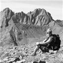
While not too long a day, this summit felt well-earned. We spent about 20 minutes taking photos, ID'ing nearby 13ers on the topo, and looking for an nonexistent register.
I busted out the JJ's #17 with extra mayo and took in the scenery. Plenty of old friends beckoned. Crestones with Milwaukee in the foreground Herard and "Medano" stand guard above the Sand Dunes
I mentioned weather and a late start... Well, these things were catching up with us. Clouds were building now, not only to the SE, but to the north. We'd started this trip hoping to grab at least Tijeras, Music, and Milwaukee, but it looked like compromise and a return trip might be on the menu. Tom had been staring down Music's intimidating, exposed south ridge all day, but his gaze and intent began to relax in the face of the weather.
Here's a look at this exposed ridge. Has anyone reading climbed this?
We headed down the standard route, hoping to see a break in the weather. We agreed to reassess things once we neared the Tijeras-Music saddle. At that point, storms looked imminent. Rain was falling on the Wet Mountain valley, not far away. Mother Nature had sheared our plans in two. I can't say that I wasn't a little relieved. Getting stuck up there in a storm could be the end of most people.
We found the northernmost gully offering passage downward, and took it.
Looking to avoid the willows, we stayed high along the grass and talus below Music's lower East Ridge, aiming for a meadow that bypassed both the willows and some cliff bands. We rejoined the trail that circumnavigates Lower Sand Creek Lake, noting that we'd probably retrace this improvised path on Sunday, en route to Music Mountain. We were out of danger, so we moseyed back toward camp. We arrived, dropped the packs, cracked the Deviant Dales we'd stashed in a nearby creek, and Tom enjoyed "the best Jimmy John's sandwich of my life." Within 15 minutes, the weather went to hell, and we hid inside my tent for about 2.5 hours of driving rain, booming thunder, and hammering hail. We pitied the large group of teenagers and the couple with a young boy who'd passed by us en route to Lower Sand Creek Lake an hour before. They must have been miserable.
While I was content to put on a puffy jacket, enjoy a Rocky Mountain High, and hang out at camp, Tom had other ideas. He asked for my keys. "Huh? What for?" The answer? "Beer run." I blinked. He looked at me impassively. Apparently, Tom was unfazed by the idea of adding another 1200' over Music Pass and back to his day. Impressed with this heroic display, I handed over the keys and marveled at this man's drive. He returned just before dark, bearing gifts, and we crashed out by 8:30, looking forward to a good night's rest and a short, but exhilarating day on Music the next morning. Knowing the forecast had relented somewhat (only 40% chance of T-storms after 1500), we agreed to depart at 0700, giving us time to summit and return to Colorado Springs for a post-climb feast to remember.
Day 2: Getting in Tune on the Pitches of Music Mountain
6.6 miles and ~2800' gain
We hit the trail for the familiar jaunt to Lower Sand Creek Lake, gawked at Tijeras once again, and sized up Music Mountain from afar. The view from here belies the mellifluous scrambling lines and enchanting summit vistas offered by this peak.
We followed the lakeside trail until it appeared to dead-end in the water to our left.
At that point, we ascended NW through the forest to treeline, making a beeline for the lower part of Music's East Ridge.
Once there, I looked down at Upper Sand Creek Lake, then ahead at the route before us. Photo Credit: Tom's iPhone
Milwaukee Peak looms to the north, with Humboldt lurking behind. See you next time!
We stopped for water and snacks, then stashed trekking poles and extra clothes. As we reached the base of our climb, things looked steep. Let the games begin!
It's a rare climb that lacks songs stuck in my head ("Theme music"). Since we were on Music Mountain, I was not surprised to have my subconscious bring the goods, leaving crappy 80s pop and bad classic rock for another day.
As I eyed my line on the initial pitch...
...this tune started echoing in the space between my ears. A propos. After some stiff, but still class 3 moves, things eased up a bit, but we tried to keep it spicy by sticking to the crest whenever possible. The terrain consisted of steep slabby rock alternating with grassy ledges. While it was really steep, there wasn't too much exposure, and only the initial moves approached class 4. It went by quickly, and we soon reached the ridge, adjacent to a false summit.
For some perspective, here's a look back toward the ridge. Most of the climb is hidden from view.
We turned our attention to the true summit, seen here.
We dropped off the false summit and faced our remaining challenge.
To this point, the scrambling had been interesting, but exposure had not been a factor. That changed quickly as we attempted to stay atop the ridge on our way over. A fall to the west would not end well. A fall to the east would last longer, but definitely be the end for someone. We kept the ridge for about half the distance, then I dropped down to avoid a reachy move. Tom stayed high, and I rejoined him. Here's a blurry me regaining the ridge. Photo by Tom
The remainder of the traverse was interesting, airy, and kept us on our toes. Some of the choices we made along the way were gambles, but they paid off.
I felt like I'd just won a round of high-stakes poker with the highest card in the deck. Lemmy would have been proud.
At this point, we had bluebird skies, and nothing to do buy enjoy.
Here's Tom checking out Pico Aislado and the Crestones.
We lounged for a good while, then thoughts of moist brisket, cream corn, sweet tea, and jalapeno sausage at Rudy's BBQ became too strident to ignore. It was time to head down. Tom grabbed this shot of me just as we approached the false summit again.
The hike back to camp went quickly and we broke camp in record time. Despite the fact that most folks say the 500' reascent of Music Pass on the way out goes quickly, I wasn't exactly excited about it with a full pack. However, it was over before I knew it. I kicked off my boots, pulled out the camp chair, and cracked a beer.
We made it to Colorado Springs, and pulled into Rudy's just minutes before a bus full of church kids. Thank God! Behind us, the line soon stretched out the door toward the Cog Railway. After enough BBQ to feed an army, we headed once again to Trinity. It's on the way home, right??? Lucky us, the beer selection had changed since Friday. Pliny in the House
Over Plinys, we reviewed pics and rehashed memories of what had proven to be a solid weekend of great climbing in the Sangres. While not quite Ice Lakes, the Music Pass area is gorgeous and worth the trip, especially for Front Range folks. We may not have summited four peaks, but the ones we got were awesome. Even with a foreboding forecast, peaks like this can get done. You just gotta go out there and give it a shot!
Heck, Slap My Mammy after yummolicious beer selections like that ... always love seeing the Pliny also (Trinity has such wonderful selections on tap). And, thanks for making me dream of Rudy's ... hell, that place alone is worth a trip down to the Springs. Your selections of brisket and jap sausage show that you know what you're talkin' about. When are they going to get the Denver location built!?! I thought that was supposed to happen this year. Your link to Motorhead brought back great memories ... Lemmy dripping sweat on my hand as it rested on the stage below his awesome bass ... that guy could play a bass like most guys wish they could play a guitar. 8) Just a stellar trip report, Matt, about an area I love to visit. Sounds like tommyboy needs to rename himself beerboy12pak. Give that man a tip already, will ya!? Thanks for posting. Great photos. Hoppy trails, my friend!
and I could not stop singing Information Society's ”what's on your mind.” So stoked that a mountain named Music could serve up some of the best scrambling in the state. I will go back for that south ridge some day because this area of Colorado deserves a return visit. Thank you, Matt, for this most excellent write up and making this last minute and spontaneous road trip down to the Sangres just as much fun.
Dave--you'd be missing out if you don't add Music. How were Clark and Lewis?
Brian--since George Clinton produced Freakey Styley, it was kind of there, but I got all the bush I could on the way up Tijeras.
Presto--that comment was as good as many TRs, images of Lemmy's ugly mug up close aside. Rudy's and Trinity are must-stops on every trip I take to the Springs.
Ryan M--it'd be cool to get out with you at some point. You've got good taste in peaks.
Scot--the Crave Challenge remains on my plate. We just need an excuse to head that way. BTW, I'll fill you in on the Beth's Cafe debacle later.
Mike--you will not be disappointed with the area. I look fwd to going back for Milwaukee-Pico.
Beerboy12pack--thanks for the route finding, beer run, and good times. Many more to come.
Thanks for this. Like how you incorporate music in your TR's but nothing will compare to that FA you put up in Aspen month or so ago. (still wondering how that trail got there )
I don't know how I missed this TR until now! I love your route up Tijeras - looks way better than the standard, which was a letdown for me last year. That east ridge on Music is familiar; I descended it last year. The south ridge is beckoning me once more; I hope to have a complete TR of it in Oct. Thanks for the beta on the part between the south summit and the true summit. Great report!
Great trip. Left Ft Collins right after dinner on Saturday, and got to see 9 moose near Cameron Pass feeding at dusk. The whole canyon is a mecca for wildlife. Got up really early to beat the possibility of 9am T-Storms. Awesome views from both L and C. It really made we want to explore the Rawahs to the north. I'd post a TR, but you've already covered it all in yours.
Is Zirkel on your radar soon? I'm heading to Steamboat the first weekend of August, but could probably take a day before or after to do that one.
Caution: The information contained in this report may not be accurate and should not be the only resource used in preparation for your climb. Failure to have the necessary experience, physical conditioning, supplies or equipment can result in injury or death. 14ers.com and the author(s) of this report provide no warranties, either express or implied, that the information provided is accurate or reliable. By using the information provided, you agree to indemnify and hold harmless 14ers.com and the report author(s) with respect to any claims and demands against them, including any attorney fees and expenses. Please read the 14ers.com Safety and Disclaimer pages for more information.
Please respect private property: 14ers.com supports the rights of private landowners to determine how and by whom their land will be used. In Colorado, it is your responsibility to determine if land is private and to obtain the appropriate permission before entering the property.


 and Milwaukee Peak")


")


 Heading up the trail with the shoulder of Marble Mountain at right")
 Tom looks out toward Music Mtn (L) and Milwaukee Peak")
")
 See those willows at the bottom? Yeah, there's more to come")
 Good Times! (Photo by Tom)")
")
")
 Photo by Tom's iPhone")
")
 What are you looking at?")
")
 Photo by Tom")
")
 Crestones with Milwaukee in the foreground")
 Herard and \"Medano\" stand guard above the Sand Dunes")
 Has anyone reading climbed this?")
")
")
")
 Photo Credit: Tom's iPhone")
")
")
")
 Photo by Tom")
")
")
")
")
 See you next time!")
 Pliny in the House")