Download Agreement, Release, and Acknowledgement of Risk:
You (the person requesting this file download) fully understand mountain climbing ("Activity") involves risks and dangers of serious bodily injury, including permanent disability, paralysis, and death ("Risks") and you fully accept and assume all such risks and all responsibility for losses, costs, and damages you incur as a result of your participation in this Activity.
You acknowledge that information in the file you have chosen to download may not be accurate and may contain errors. You agree to assume all risks when using this information and agree to release and discharge 14ers.com, 14ers Inc. and the author(s) of such information (collectively, the "Released Parties").
You hereby discharge the Released Parties from all damages, actions, claims and liabilities of any nature, specifically including, but not limited to, damages, actions, claims and liabilities arising from or related to the negligence of the Released Parties. You further agree to indemnify, hold harmless and defend 14ers.com, 14ers Inc. and each of the other Released Parties from and against any loss, damage, liability and expense, including costs and attorney fees, incurred by 14ers.com, 14ers Inc. or any of the other Released Parties as a result of you using information provided on the 14ers.com or 14ers Inc. websites.
You have read this agreement, fully understand its terms and intend it to be a complete and unconditional release of all liability to the greatest extent allowed by law and agree that if any portion of this agreement is held to be invalid the balance, notwithstanding, shall continue in full force and effect.
By clicking "OK" you agree to these terms. If you DO NOT agree, click "Cancel"...
After climbing Longs Peak for the ninth time, I wasn't planning to do a trip report. But because my wife Jen and I descended it in a relatively uncommon way, with an ascent of Southeast Longs (aka The Beaver) tacked on, I thought I'd put up some photos and text in case someone was looking for information on this route.
After doing this loop counter-clockwise, I now understand why so many do it clockwise. Doing it the way we did it posed some routefinding challenges and it was awkward in a few sections. But it was definitely interesting.
The first third of the loop was dark and typical, so I won't bore you with the details.
Me on the Chockstone and the Narrows:
Summit pan of Rocky Mountain National Park (looking west):
It was a great feeling to revisit Longs Peak's summit. It is truly a special place.
Once we began our descent, things became even more interesting. After scampering down the Homestretch (upper-right in the following photo) and over a rib of rock, we started straight down the scree and talus.
The following shot, a two-photo pan, was taken looking back, upslope (our descent route is in red; climbers are circled in orange):
It wasn't obvious at first, but after hiking down 100 feet or so and then angling to the left, directly below the Homestretch, the route slowly unfolded before us.
In the following photo, the red line was our approximate route below the Palisades (the orange dots in two of the photos designate the location of Clark's Arrow).
Once we got into Keplinger's Couloir, just below the Notch, we faced our first routefinding challenge. The terrain wasn't familiar, even though we had climbed the Loft Route two or three times before. Granted, it was years ago, and we climbed it the "normal" way. I suppose I should've looked back more.
Speaking of which, here's a look back on our route from the Homestretch (the Homestretch is the red line at the top of this image and the Notch is out of view, upper-right):
Even though I didn't remember having to traverse over a couple ribs of rock beyond Keplinger's, I knew it was the right way to go. We decided to stay high and close to the base of the Palisades, and the cairns we came across only reassured that decision.
While taking a short break, I looked up and saw a huge boulder wedged in a chimney directly above us, making our rest spot less than ideal. How that two-ton boulder got into that spot is beyond me. Here's a three-photo, vertical pan of the curious boulder:
As we continued to traverse Longs' backside, Clark's Arrow came closer into view (circled in red):
Instead of climbing up this section the way we used to down climb it (just behind the Clark's Arrow boulder in the following photo, and to the left of Roach's DVD down climb), we found another option to the left of the Clark's Arrow boulder.
If you take your time, you can actually find multiple routes up/down in this area. Of course, some are more difficult than others.
We decided to go up just to the left of the Clark's Arrow boulder. We just walked up some rocks to the left, stemmed up a v-notch, and then scrambled up some steep but fairly solid rock:
Beyond that section, there was just one more class 3 maneuver. It wasn't overly difficult, but it was a little awkward for us height-challenged folk:
From there, it was more or less just a hike over to the Loft. But instead of taking the cairned path, we headed straight up the talus slope toward Southeast Longs.
Some of the boulders were surprisingly large. I would compare the terrain to the Boulderfield below the Keyhole, only steeper.
Halfway up the slope to Southeast Longs I took this pan of Mt. Meeker:
I can't remember exactly, but I think it took us about a half hour to climb the 500 feet or so up to The Beaver's nose.
Here we are on Southeast Longs' airy perch with Longs proper behind us:
I waved to a few people on top of Longs Peak and they waved back, which was kind of cool.
Looking to the northwest, we could see climbers on the Keyhole Route, just below the Homestretch:
When you're on the Loft, Southeast Longs doesn't look so tough. It just looks like a simple scree field. But it's longer and higher than it looks, and what appear to be small rocks are actually large boulders:
After climbing Longs and SE Longs, we weren't home free yet, as we still had to find our way back down. And, I'll admit, descending the Loft was a little intimidating, especially since no one was coming up to give us a better idea of where to go.
Scrambling up to the Loft is challenging enough, but it's much easier than scrambling down from the Loft. This is probably why so many people do this route up and not down.
Cairns blended into the terrain, so they were only slightly helpful.
We tackled the challenge in small bites, and we took our time so as not to get ourselves in a bad spot.
At one point I could see some paths right below us, but they looked loose and steep, and they appeared to cliff out. So we traversed farther to the right and found a slightly better way down. When we started moving back to the left, we passed right beneath the grassy ramps most people take on the way up. Then we saw a climber working his way up (circled in red in the following photo). Other than the two pairs of climbers we saw on the Loft while we were on SE Longs, he was the only climber we encountered between the Homestretch and Chasm Lake.
From there, we just worked our way down all the ledges and slabs like a game of Plinko. If I did it five more times, I'd probably end up going five different ways.
Descending the Loft required much more scrambling than I remembered, but for the most part it was fun.
Below the slabs, it was just a long slog down loose scree and squishy grass to the Chasm Lake trail, which held throngs of hikers.
Here's a look back on our approximate descent route, viewed from the trail just below Mills Moraine:
We passed all types of hikers. Some of them smelled worse than others.
I guess it does kind of look like a beaver, though I think a marmot would be more appropriate:
Here's a map of our approximate route; the red line is our ascent route via the Keyhole and the green line is our descent route via SE Longs and the Loft:
Overall, I think we did pretty well on this tour, especially for a couple sea-levelers. I credit our success to our strong acclimatization plan, which included drinking lots of fluids (including massive amounts of beer), some stays at high-elevation hotels, some afternoon drives to high places and some prep climbs, such as ...
... Mt. Flora:
... Mt. Evans:
... and Kelso Ridge on Torreys Peak:
(*The road up to the Grays/Torreys trailhead was pretty rough in one spot, exactly 1.6 miles from the I-70 parking lot, but I made it up OK in a Nissan Murano rental.)
On this trip people kept asking us if we missed Colorado. We do, of course. Who wouldn't? It has a ton of awesome mountains, many great restaurants and some of the best breweries in the country, plus we miss our friends.
Among the 48 states I've been to and the 8 states I've lived in, Colorado is without a doubt one of my favorites. But this country is filled with so many amazing places and amazing mountains, and I've been very fortunate to see so much of it.
Even though a portion of our hearts are still in Colorado, we are really enjoying our new home in Washington state. And even though we now live at just 60 feet above sea level, which creates an added challenge for high-altitude climbing, we're not necessarily flatlanders.
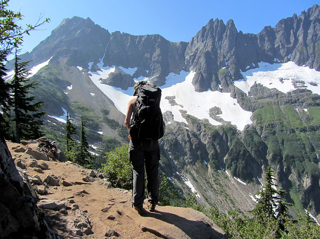
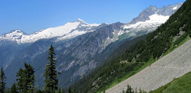
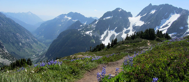
The day after we got home, we took advantage of our newly acquired red blood cells and did a day hike up the Sahale Arm above Cascade Pass, which is a couple hours away from our house. In case you're interested, I thought I'd cap off this TR with some of the photos I took on that hike:
Thumbnails for uploaded photos (click to open slideshow):
Well done with that Long's trip report! We have done the loft route before for Meeker, but in all the times we've done Long's Peak, we've never done it from there. We will need to remedy that very soon ... . Always love to see Washington photos ... Cascade Pass is a special place ... you've got a great shot of Eldorado Peak in that second photo. Git yer butts up there. 8) It was great meeting you two last week. The next time we're in Washington, we'll look you up for sure. Thanks for posting. Happy trails to you both!
Longs (up via Loft, down via Keyhole) was my first 14er -- long (no pun intended) before I had any concept of wanting to summit all of the 14ers. Must have been 1988.
After reading your report I want to go back and climb the Beaver.
Caution: The information contained in this report may not be accurate and should not be the only resource used in preparation for your climb. Failure to have the necessary experience, physical conditioning, supplies or equipment can result in injury or death. 14ers.com and the author(s) of this report provide no warranties, either express or implied, that the information provided is accurate or reliable. By using the information provided, you agree to indemnify and hold harmless 14ers.com and the report author(s) with respect to any claims and demands against them, including any attorney fees and expenses. Please read the 14ers.com Safety and Disclaimer pages for more information.
Please respect private property: 14ers.com supports the rights of private landowners to determine how and by whom their land will be used. In Colorado, it is your responsibility to determine if land is private and to obtain the appropriate permission before entering the property.


")
")
")
")
")
")
")
")
")
")
")
")
")
")
")
")
")
")
")
")
")
")
")
")
")
")
")
")
")
")