Download Agreement, Release, and Acknowledgement of Risk:
You (the person requesting this file download) fully understand mountain climbing ("Activity") involves risks and dangers of serious bodily injury, including permanent disability, paralysis, and death ("Risks") and you fully accept and assume all such risks and all responsibility for losses, costs, and damages you incur as a result of your participation in this Activity.
You acknowledge that information in the file you have chosen to download may not be accurate and may contain errors. You agree to assume all risks when using this information and agree to release and discharge 14ers.com, 14ers Inc. and the author(s) of such information (collectively, the "Released Parties").
You hereby discharge the Released Parties from all damages, actions, claims and liabilities of any nature, specifically including, but not limited to, damages, actions, claims and liabilities arising from or related to the negligence of the Released Parties. You further agree to indemnify, hold harmless and defend 14ers.com, 14ers Inc. and each of the other Released Parties from and against any loss, damage, liability and expense, including costs and attorney fees, incurred by 14ers.com, 14ers Inc. or any of the other Released Parties as a result of you using information provided on the 14ers.com or 14ers Inc. websites.
You have read this agreement, fully understand its terms and intend it to be a complete and unconditional release of all liability to the greatest extent allowed by law and agree that if any portion of this agreement is held to be invalid the balance, notwithstanding, shall continue in full force and effect.
By clicking "OK" you agree to these terms. If you DO NOT agree, click "Cancel"...
Gannett Peak August 11, 12, 13 Ascent: Southeast Couloir Descent: Gooseneck Glacier Mileage: Approx 42 miles Vertical gain: 10,000ft
Day One Elkhart TH to Titcomb Basin
Approx 3k vert & 15 miles, 7 hours (with 40 minute wrong turn)
After breakfast at the Wrangler Caf� in Pinedale, Wyoming on Saturday morning, we drove the 15 miles to the paved trailhead to begin the 15 mile hike into Titcomb Basin. With the low snow year and hot summer in the Wind River Range, we packed as light as we could manage for roped glacier travel.
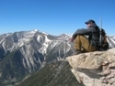
After about 4.5 miles we reached Photographer's Point. This is the point where it really sets in how far away the destination is. Dan on the left, me in the center, and YC on the right.
Senaca Lake at 8.5 miles from the TH was impressive, but Island Lake, at 11.7 miles in was breathtaking. In the distance behind Island Lake is Bonney Pass (center of photo), which we'll climb the next morning in route to Gannett. Shortly before this photo was taken our friend Marc radioed me from Bonney Pass. Marc and Dave drove from Denver to the TH after working a half day Friday, started hiking 10pm Friday evening, but were forced to turn around early Saturday afternoon shortly before Gannett's summit.
Our relaxed pace allowed for a little beach time as we rounded Island Lake.
Continuing into Titcomb Basin.
We stopped between Titcomb Lakes around 5pm to setup camp and rendezvous with Marc and Dave. They handed off their rope and Marc gave us beta on the southeast couloir before they decided to forego their bivy bags and set off for the TH. It ended up being a 28 hour push for the two of them.
Our camp with Bonney Pass in the background.
Day Two Approx 5,600 vert, 12 miles, 15 hours
Left camp around 5:30am, heading around upper Titcomb Lake.
In a more typical year Bonney Pass might still be a snow climb. This year it's already steep scree and loose rocks. It's tough to move quick through this terrain and it took us 2:15 to climb the 2,100 feet from camp.
I think every TR from this route on Gannett has this same picture, and for good reason; after 18 miles of hiking the first view of Gannett is worth the wait.
Next on the agenda is a 400ft hike down more loose rock, followed by another 700 vertical foot descent down the Dinwoody Glacier. Quite a few crevasses have opened up so we roped up from the start.
Having inaccurately heard that the bergschrund on the standard route probably wasn't passable, and knowing that the southeast couloir was doable, we chose to ascend the couloir. I labeled our route on this pic Sarah Meiser took from Sunbeam Peak a couple weeks ago. Thanks for the shot Sarah.
Talk on the trail was that crevasses have already appeared that haven't been seen in years. Definitely felt like more of a glacier climb than we expected.
Finishing our descent to 11,500ft on the Dinwoody Glacier.
We hung a left and Dan began navigating the way towards the southeast couloir.
As we could tell from Bonney Pass, access to the couloir wasn't a gimmie. We decide the right bridge looked better.
The southeast couloir is about 600 vertical feet and peaks at maybe 40 to 45 degrees. While not overly steep, the snow was firm and there was a bergschrund awaiting an unarrested fall. Since we weren't placing protection, we unroped. To make sure we could safely downclimb the couloir on the way back, I took the time to cut most steps with my axe. Since I was wearing trail runners, YC worked on the steps too with his mountaineering boots as he brought up the rear.
Shortly after reaching the top of the couloir we gained the summit ridge and got a view of the Mammoth Glacier on Gannett's east side.
Dan and YC nearing the top.
Nearing the summit we got an excellent view of the open bergschrund on the Gooseneck Glacier. Not wanting to descend the southeast couloir, we formed a plan to downclimb the rock lookers left of the snow and hope the 30m was long enough to get us down. Worst case scenario, we would tie off the rope and leave it.
We made the summit a little over 7 hours after leaving camp. In that time we had only seen one other group, descending the Dinwoody Glacier about a half mile in front of us.
Dan, YC, and me, on the summit of Wyoming's tallest peak.
As we descended off the summit ridge we bumped into the group we had seen in front of us earlier in the morning. It was the group from Idaho that we talked to the day prior. They had ascended the standard route but got caught up deciding how to negotiate the bergschrund. Ultimately, they went climbers left and ascended the rock. They also told us about a 60m rope someone had left over the bergschrund.
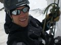
I rappelled down to the anchor a previous party had built and tested it while still on rappel. Having determined we would use the pickets and rope left by another group, I readied the anchor while Dan rappelled to me. Once Dan arrived, he used the 60m to rappel over the bergschrund while I belayed YC to me on our 30m.
We rappelled over the bergschrund with YC bringing up the rear. In retrospect, YC could have downclimbed on belay, which would have allowed us to clean the anchor. Although we felt confident in the anchor, another week of warm weather could easily change that. As you can see here, the bergschrund is still passable by parties ascending this route.
Once over the bergschrund we made an easy snow traverse to the Pinnacle Ridge. From there we could see the glaciers we descended and ascended in the morning, as well as Bonney Pass in the distance.
After descending another 1,000 feet on rock we reached the snow and put the rope back on for the climb to Bonney Pass.
Thanks to Josh's recent trip report I learned that this glacier water slide is called a moulin. We had simply been calling it "your last water slide."
We got back to Bonney Pass about 12 hours into our day, facing a long loose descent back to camp.
It has been a while since I had a 15 hour day in the mountains, but this one was well worth it. We rolled back into camp with just enough daylight and energy to pump some water and down some food before crashing.
Day Three Titcomb Basin to Elkhart TH
Approx 1,400 vert & 15 miles, 7.5 hours
The last five miles were rough. Feet were pretty sore. I can't imagine doing this peak in a single push as some have achieved and Marc/Dave came close to pulling off. Although this climb might be easier when the crevasses are filled in, I think doing it later in the season gives you more of a glacier climb feel, and a lot less mosquitoes. Certainly one of the more unique and amazing mountains I've been fortunate enough to climb.
Thumbnails for uploaded photos (click to open slideshow):
Wow! I love alpine lakes, but this one is as you say, ”breath-taking”. Congrats on a great climb. Gannet peak is one of those ”just maybe someday” peaks. So reading a great TR about it like this is super.
Nice report Carl. Way to cover all that ground in 3 days. Image 2 doesn't even look real... I'm hoping to make it up there in 2013 and spend a few days. Solid work gang.
Way to get after the highest peak in WY! Loved the report and pics! Gannett was literally my first attempt at a proper mountain back in 9th grade of high school - a guided trip with Exum for my birthday from my folks. We were not successful - weathered out at the top of Dinwoody Pass but I've always wanted to go back. Just havent yet. Your TR makes me want to make this a priority perhaps for next summer.
Having also heard the bergschrund was impassable, we'd given up on the idea of our Gannett trip this year. Just might have to change our minds on that. Awesome report, thanks for the beta!
Carl - its good to see you chose the non-blitzkrieg approach to this gem of a basin. So there is more to Wyoming than banging sheep? I was under the impression it was that and surviving borderline suicidal climbs in the Tetons.
Why is that every out of state report seems to blow any non-Weminuche Colorado TR out of the water? Wind Rivers, Sierras, Cascades, Alaska, etc. I guess there is just a lot to explore in the lower 48.....
I got a pretty good laugh out of the ”your last waterslide”. Sure to keep the riff raff at bay.
photos #2 and 4 are jaw-dropping. I've visited Yellowstone & Teton and spent a good amount of time in the Big Horns, but have to yet to venture into the ”heart” of Wyoming, which seems to be the Winds and Gannet in particular.
Great report, Carl. I agree w/ Helmut, most of the out-of-state/country TRs are tough to beat, and this one is no exception!
Wow, that is a long hike. I first saw pick 1 of you guys and figured it was taken across the state or something, that was 4.5 miles into the hike from the car? I really want to climb in the Winds, but sounds like I need to do some more research on the distances so I know what I am getting myself into first
Awesome trip and a great report. So many great images I can't even pick out a favorite.
Rob - Trail runners were pushed somewhat in a few spots, but nice to shave the weight. The FKT on Gannett I think is by 14ers.com member Peter Bawkin via Tourist Creek (36 miles instead of 42) at 12:39. FKT on the standard route that we did is 12:45 by Andy Dorais. With more snow in the right places I'm pretty sure I could destroy myself and do this peak in 24 hours. I can't imagine ever doing it in half that time like Peter and Dorais.
I've been meaning to read this since you posted it and finally got around to doing it. I enjoyed seeing the route you took since we went back and forth on taking that SE couloir ourselves. Great write up and photos.
and congratulations on a well-deserved summit. It's quite interesting the difference a month makes. I was on Gannett on July 12-13th and the bergschrund was just starting to open on one side. It looks like they've had some pretty warm weather in the Winds that's erasing the heavy snows from last winter.
Caution: The information contained in this report may not be accurate and should not be the only resource used in preparation for your climb. Failure to have the necessary experience, physical conditioning, supplies or equipment can result in injury or death. 14ers.com and the author(s) of this report provide no warranties, either express or implied, that the information provided is accurate or reliable. By using the information provided, you agree to indemnify and hold harmless 14ers.com and the report author(s) with respect to any claims and demands against them, including any attorney fees and expenses. Please read the 14ers.com Safety and Disclaimer pages for more information.
Please respect private property: 14ers.com supports the rights of private landowners to determine how and by whom their land will be used. In Colorado, it is your responsibility to determine if land is private and to obtain the appropriate permission before entering the property.


")
")
")
")
")
")
")
")
")
")
")
")
")
")
")
")
")
")
")
")
")
")
")
")
")
")
")
")
")
")