Download Agreement, Release, and Acknowledgement of Risk:
You (the person requesting this file download) fully understand mountain climbing ("Activity") involves risks and dangers of serious bodily injury, including permanent disability, paralysis, and death ("Risks") and you fully accept and assume all such risks and all responsibility for losses, costs, and damages you incur as a result of your participation in this Activity.
You acknowledge that information in the file you have chosen to download may not be accurate and may contain errors. You agree to assume all risks when using this information and agree to release and discharge 14ers.com, 14ers Inc. and the author(s) of such information (collectively, the "Released Parties").
You hereby discharge the Released Parties from all damages, actions, claims and liabilities of any nature, specifically including, but not limited to, damages, actions, claims and liabilities arising from or related to the negligence of the Released Parties. You further agree to indemnify, hold harmless and defend 14ers.com, 14ers Inc. and each of the other Released Parties from and against any loss, damage, liability and expense, including costs and attorney fees, incurred by 14ers.com, 14ers Inc. or any of the other Released Parties as a result of you using information provided on the 14ers.com or 14ers Inc. websites.
You have read this agreement, fully understand its terms and intend it to be a complete and unconditional release of all liability to the greatest extent allowed by law and agree that if any portion of this agreement is held to be invalid the balance, notwithstanding, shall continue in full force and effect.
By clicking "OK" you agree to these terms. If you DO NOT agree, click "Cancel"...
Location: North Cascades region of Washington state, right on the border of North Cascades National Park; the trailhead is about 2 hours from Bellingham or 2.5 to 3 hours from Seattle Summit Elevations: lookout (south summit) is 6,890' and the true summit (north summit) is 7,088' Round-trip Distance (both summits): 10 miles Total Elevation Gain (both summits): 3,800 feet *You can click to enlarge most of the photos in this trip report; the pans look best at full size
Sometimes you do a hike where everything just seems to coalesce into an amazing experience. It's the kind of hike that offers a nice variety of terrain, a challenging amount of distance and gain, some spectacular views, amazing weather, and great company with which to share it all. Our hike up to Hidden Lake Peaks on Sept. 30 was one such hike.
I've done some 5-star-rated hikes in Washington state, but I really feel like this one should be a 6. It's that good.
Beyond its incredible beauty, this hike has two uncommon-for-Washington attributes: Half of the trail is above treeline and (assuming you do both summits) it features a good mile or so of fun scampering and scrambling on solid, grippy rock. And even though you'll spend more time in an alpine wonderland on this hike than most others in Washington, you'll wish it lasted longer.
Adding to the special, ephemeral nature of this hike, there's only a small window of time to climb these peaks snow-free, which is typically from mid-August through mid-October. While it can be done other times of the year, it requires technical equipment, as there are some sketchy snow/ice crossings that run out over cliffs, and the approach route is in a high avalanche area.
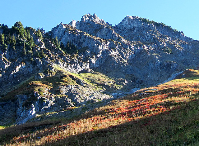
As soon as we popped out of the damp forest, the low-angled morning sun created some dramatic views on the rocky outcrops at the head of the gully:
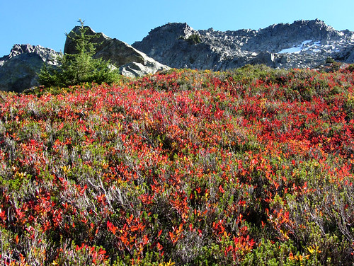
Meanwhile, fall colors raged on the ground:
The views of the peaks across the valley behind us were incredible. And just when I thought the views couldn't get any better, they did. And they just continued to improve exponentially the higher we climbed.
Somewhere along the way we finally noticed the old fire lookout, which appeared to be unattainable on top of a large spire. You can barely see it, upper-left, in the following photo.
Snowking Mountain looked like it was slathered in vanilla frosting:
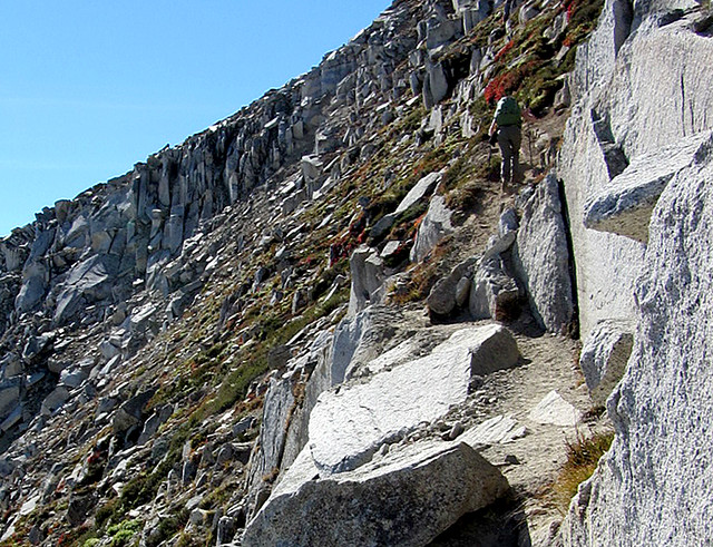
After gaining the saddle between the two Hidden Lake Peaks, we followed the narrow trail up the steep slope to the lookout (hikers are circled in the following photo).
The trail was only a foot or two wide in some sections, with loose dirt and gravel to contend with, so we had to step carefully, but none of it was overly difficult.
Two and a half hours after starting this hike, we made it to the south summit, and we were greeted by jaw-dropping views in every direction:
Glacier Peak and the Buckindy Group:
Zoomed-in shot of Glacier Peak:
The bolted-down fire lookout cabin is precariously perched prominently above the valley floor. The photo doesn't do the elevation difference justice, so here are some numbers to wrap your mind around: The elevation of the valley floor directly below (on the right side of the following photo) is about 1,100' and the lookout is at 6,890', and we weren't even on the tallest peak in the area. Nearby Eldorado Peak is almost 2,000 feet higher.
The cabin sleeps about four, on a first-come, first-serve basis.
Summit pan to the east:
In the following photo you can see white smoke in the distance from the massive Table Mountain wildfire, which as of writing this, has grown to more than 60 square miles and it's only 55 percent contained (Spider Mountain and Mt. Formidable on the left):
Here's another summit pan - Left to Right: North Hidden Lake Peaks (our next destination), Eldorado Peak (8,876'), Forbidden Peak, Boston and Sahale, Johannesburg Mountain, and Hidden Lake in the foreground, with Cascade Pass just around the bend and out of view:
Pan to the north, with the serrated Rivalry Ridge in the foreground and the Picket Range top-center:
Two people on the true/north summit of Hidden Lake Peaks (our next destination), with Eldorado Peak in the background:
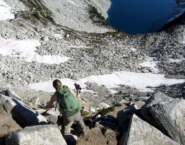
Hiking back down to the saddle:
Mount Baker's southeast side:
Our rough route up the ridge from the saddle (fun and easy class 2 and 3, with some exposure, most of which could be avoided by traversing across talus slopes or snow):
Here's another photo of the ridge, taken near the saddle:
For the most part, we stayed on the crest of the ridge and thoroughly enjoyed the solid-rock scrambling, which is a rarity in Washington:
Amazingly, the views from the north summit were even better than the south summit.
There was even a summit boulder to scramble up:
South/lookout summit viewed from the north/true summit:
Eldorado, Formidable, Boston & Sahale from the north summit:
After soaking in the spectacular, 360-degree views through crystal-clear skies for a good amount of time, we scrambled back down the ridge with a friendly family of three.
Here's a shot of the south summit from the ridge (the lookout is on top, just out of view, and if you enlarge the image you can see the trail switchbacking up the left side):
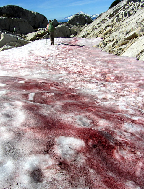
On our hike back down, we were treated to more sights that we didn't really notice on the way up, such as some of the darkest and most widespread watermelon snow I have ever seen:
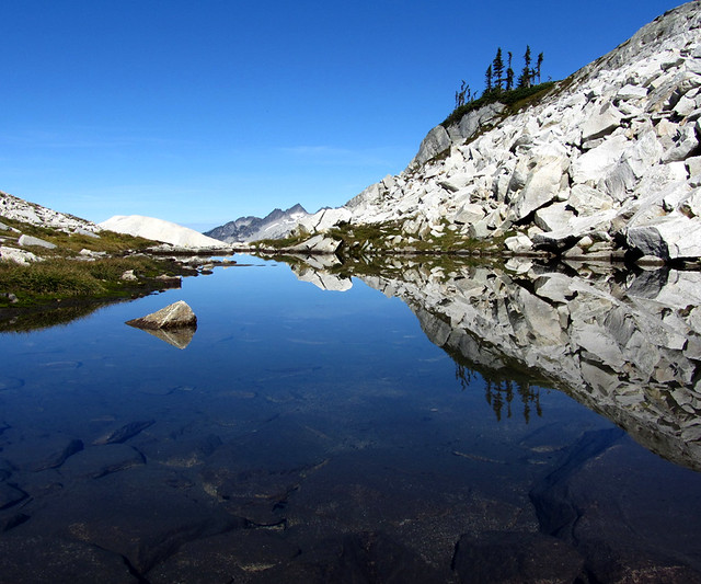
And we came across this neat little tarn:
In the two years Jen and I have lived in Washington, we've done many amazing hikes and climbs in the North Cascades region. But this one easily ranks up there with my favorites. It really blew me away.
Thumbnails for uploaded photos (click to open slideshow):
More to the PNW than volcanoes I guess. Wow. Pictures don't even need to do this area anymore justice than they already did. I'm sold. You seem to capture the true essence of the Northern Cascades in all your TR's Aubrey.
On a side note, that watermelon snow looks like a family of bear massacred a herd of deer.
Jaw-dropping views aplenty!
And, very non-PNW-like of you, you actually went to the summit!
You can take the hiker out of Colorado, but you can't take the Colorado out of the hiker...
MtnHub, I still miss Colorado in many ways, but you make a good point; it's pretty good here, too. Anna, I highly recommend this hike -- in late August or September. Floyd, give me a heads up next time you're up this way. We can do a mountain or beers, in the least. I'll let you know if I win a ticket to Beer Camp; still waiting to hear back -- thanks for your vote! Nedryarson, thanks, I think that's my favorite pic, too. Mindy, the North Cascades N.P. is one of the least-visited national parks. It's rugged, remote and difficult to access, but it's worth it. Before moving here -- even after climbing Rainier before moving here -- I had no idea about its beauty. Lordhelmut, thanks, and you never cease to crack me up. Doctor No, do it. It was a fantastic day. Matt, so true ... but in this case, we were actually after the solid-rock scrambling, and the true summit was secondary.
Your reports continue to sell me on finding a job up there. Good to see you and Jen getting out! Should you ever venture back to CO for a visit, I'm sure there will be a good number of us who'd like to get out with you two and hear all about your adventures in WA.
Caution: The information contained in this report may not be accurate and should not be the only resource used in preparation for your climb. Failure to have the necessary experience, physical conditioning, supplies or equipment can result in injury or death. 14ers.com and the author(s) of this report provide no warranties, either express or implied, that the information provided is accurate or reliable. By using the information provided, you agree to indemnify and hold harmless 14ers.com and the report author(s) with respect to any claims and demands against them, including any attorney fees and expenses. Please read the 14ers.com Safety and Disclaimer pages for more information.
Please respect private property: 14ers.com supports the rights of private landowners to determine how and by whom their land will be used. In Colorado, it is your responsibility to determine if land is private and to obtain the appropriate permission before entering the property.


")
")
")
")
")
")
")
")
")
")
")
")
")
")
")
")
")
")
")
")
")
")
")
")
")
")
")
")
")
")


