Download Agreement, Release, and Acknowledgement of Risk:
You (the person requesting this file download) fully understand mountain climbing ("Activity") involves risks and dangers of serious bodily injury, including permanent disability, paralysis, and death ("Risks") and you fully accept and assume all such risks and all responsibility for losses, costs, and damages you incur as a result of your participation in this Activity.
You acknowledge that information in the file you have chosen to download may not be accurate and may contain errors. You agree to assume all risks when using this information and agree to release and discharge 14ers.com, 14ers Inc. and the author(s) of such information (collectively, the "Released Parties").
You hereby discharge the Released Parties from all damages, actions, claims and liabilities of any nature, specifically including, but not limited to, damages, actions, claims and liabilities arising from or related to the negligence of the Released Parties. You further agree to indemnify, hold harmless and defend 14ers.com, 14ers Inc. and each of the other Released Parties from and against any loss, damage, liability and expense, including costs and attorney fees, incurred by 14ers.com, 14ers Inc. or any of the other Released Parties as a result of you using information provided on the 14ers.com or 14ers Inc. websites.
You have read this agreement, fully understand its terms and intend it to be a complete and unconditional release of all liability to the greatest extent allowed by law and agree that if any portion of this agreement is held to be invalid the balance, notwithstanding, shall continue in full force and effect.
By clicking "OK" you agree to these terms. If you DO NOT agree, click "Cancel"...
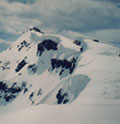
Teakettle Mountain-13,819
13er Rank in CO: 98 of 637
Climb Date: 28 April, 2013
Crew: Jim Yaich (Yikes), Jorge Gonzales (gonzalj), Britt Jones (globreal)
Mileage: Approximately 5 miles
Vertical Feet: 3,200
Total Climb Time: 7 1/2 hours
Trailhead: Revenue Mine/10,600 or 1.2 miles shy of the summer TH (Outhouse)
Teakettle Mountain-A Stellar Snow Climb! Teakettle Mountain-13,819 Photo by gonzalj
With only a cell phone camera, this was never intended to be a fancy, dancy trip report. I decided to do one because I noticed that there weren't any other Teakettle TR's in April. (That is until yesterday...one just posted by benners.) And second, because there aren't to manyTR's for this mountain. So, hopefully this will be useful to some.
From other reports, this climb is an ugly climb in summer due to the nasty scree on the upper steep slopes. So, I was hoping to do this as a snow climb. However, if you look at photos of Teakettle from CoffeePot which is the standard approach route, a south face climb looks blocked by three steep cliff bands.
I read Mad Mike's TR where he had gone up the south facing couloir, in May two years ago. Mike's TR unlocks the route. His report and route called me.
This April, Colorado had received several snow storms which made the northern part of the state loaded with lots of new snow and high avalanche danger. In fact, on April 20th, 5 guys died in that horrible Mt. Sniktau avalanche. So, for me, the Elks were out and north facing slopes were out. The southern San Juans were in the green zone on CAIC, and our climbing day would be 4 days after a sunny, thawing/freezing cylce. So, Teakettle was chosen for April 28th.
Driving into Ridgeway from Montrose on Hwy 550 presents this superb view of the San Juans! San Juan view from Ridgeway, CO
I had been in contact with benners who was skiing peaks in the Yankee Boy basin. The beta he offered was showing favorable conditions with stable snow.
We camped in the Angel Creek campground (with benners and company) which is approximately two miles up Ouray County Rd 361 (on the right) up the road from Ouray.
In case you don't know, this road to Yankee Boy Basin usually is gated by the mining companies in winter at 9,200 feet. This is 4 miles shy of the summer TH. There is a sign at the gate that says CLOSED UNTI MAY 1. However, that wasn't the case. The gate had been left opened and unlocked all week. So, if you are aiming to get into Yankee Boy Basin in the winter months, check first as the gate may be open. This shortned our approach 2 3/4 miles as we were able to drive on up past the Camp Bird Mine and up to the Revenue Mine near the old Sneffels townsite.
We left camp at 3:45am and drove up the road to 10,600 feet which is obviously as far as the road gets plowed to in winter. We were hiking shortly after 4am. Our goal was to get up and down early before the sun had much time to warm up the snow slopes which would up the ante for wet avy slides.
Our route took us snowshoeing up the road 1.2 miles which is just about 200 yards shy of the summer TH/outhouse. It's about 11,300 in an open clearing where we veered right and headed up hill aiming directly at the Teakettle summit.
gonzalj heading up the ramp
We were greeted with a warm alpenglow on the summits across the Yankee Boy Basin. San Juan sunrise Photo by gonzalj
Up in the big amphitheater/basin, Jim finds a large flat rock/table top to take a break on. Yikes taking a short break.
From our conversation with benners and Lordhelmut the evening before, there was no mention of a avalanche having come down the gulley. To our surprise, we were greeted with this! Photo taken on descent
Apparently this came down during the night! The "snowballs" were huge and as hard as concrete! However, I was very grateful to see it down here in the amphitheater as that meant our coulior climb should be much safer.
Yikes is leading the charge over the debris field and up the couloir. Avy debris with Yikes heading up
Jorge is taking up the rear as we make our way up. And from the looks of these walls, we should have ample time to get down before the sun can reach into here. Looking down gully with gonzalj heading up
Yikes is approaching the upper portion of the couloir. There were places in here where it was very difficult to kick steps. So I made a mental note, this gully would be virtually impossible to climb without crampons. Microspikes...forget it. Yikes at gully exit
I measured the slope angle in this area and found it to be just over 50 degrees. Quite fun but it does get your attention! Jorge decided to turn back about halfway up this steep gully. I tried to convince him to continue but he was happy with the climb he had thus far. Back down south gulley
Jim and I continue. There is a nice gentling of the slope angle if you veer right or a more easterly direction instead of trying to continue straight up. This was the recommendation of benners and company, and it works perfectly. Yikes about to enter into the sunrays
Once out of the gully, you are graced with the most majestic view of Potosi Peak (13,786) to the southeast. Potosi Peak after topping out of gulley
Looking southwest across Yankee Boy Basin now gives you this gorgeous view of Gilpin Peak (13,694.) Gilpin Peak
In this open area above the couloir, the temptation is to aim back right at the Teakettle summit. I believe this is the way Mad Mike went which takes you to a cliffy scramble. You can avoid all that by continuing east and under the rocks you see in this next picture. First view of Teakettle after gulley exit
I took a screenshot from Google Earth and drew in the route. Green is what I think Mad Mike took. Red is what we did. It's nice gentle slopes this way. Google Earth view of upper route
And once you turn back west, you are greeted with the infamous Teakettle handle.
And there she is...our goal for the day. The Teakettle Handle
From where Jim is, that's where I took the Teakettle handle shot. But this view is equally awesome! Yikes rounding the bend with Pototsi behind
At the base of the summit tower, I got out my 30 meter rope and we both harnessed up. Jim took the lead and took the snow ramp to the right. At the point where he is in this photo, is a precarious move to hang onto the wall to make it left over into the chimney. Not easy and pretty scarry. It's no longer a hike!
Jim wore his crampons to the summit. That was probably the best idea because I actually had a slip where my wet hiking boot slipped off the wall. (Hindsight, we should have brought our rock shoes.) We decided not to as the rating was only 5.3. However, this felt way more than 5.3 in winter conditions. The hand holds and footholds were probably hiding under snow even though you hardly see any from this lower photo angle. Yikes is a great lead climber!
I was totally amazed after climbing the chimney that Jim was able to lead it. It was hard! Much more difficult than what I have heard people report this to be. Again...probably due to the snow. Jim, great job buddy! Jim looks happy
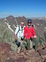
Boy was I thrilled to have made it on top! Britt is REALLY happy
This was our view looking west to Cirque Mnt and Mount Sneffels under blue bird skies and no wind. Cirque Mnt-13,686, Sneffels-14,150
Looking back down at our tracks and Potosi Mountain. Our tracks and Pototsi Peak-13,786
A few footnotes:
From car to summit took us 5 hours. That doesn't seem to good when it was only about 2.5 of mileage. However, I was just fine with our time as it was only shortly after 9am.
Suggested gear for this time of year...beacon, probe, shovel, crampons, helmet, harness, 30m rope, ATC, biners, rack/pro, rock shoes, ice axe, snowshoes. (Not a one of these would be unnecessary gear in my opinion.)
Just because the gate is supposed to be closed and locked in wintertime doesn't mean it always is.
And really check your avy danger. And even when you do, you just never know when one is going to come down as we found out.
benners, Lordhelmet, Elliot, CALC, thanks for the beta and refreshments!
What can I say? I made it to the center of the sweetspot with the weather, conditions, good health, and a great lead climbing partner. Jim, you made it happen. Thank you!
Another day of answered prayers! God is good. The Teakettle Handle
Now...12 more Centennials to go...
Thumbnails for uploaded photos (click to open slideshow):
Great work guys, that summit block during snow season is nothing to scoff at. You're so close to the top 100 Britt, go get the rest of em! It was good seeing you again. Yikes, Gonzalj, good meeting you up there.
Cheers!
P.s. That slide definitely occurred in the afternoon after we skied the gully. You can see the debris partially covers our tracks. Glad no one was around to witness that first hand!
Even though I wasn't able to get past that spot in the couloir where I couldn't get secure footing to keep going up, it was really great going out with you guys. Benners, it was really great to meet you & Lordhelmut.
12 sweet peaks left it sounds like. Good to meet you guys. I heard you and Yikes descending that afternoon. Thats certainly the way to climb that chossy mess of a mountain.
Nice work guys! Congrats on #88 (your 5 ahead of me), and getting a tough one in the books! Doing Teakettle as a snow climb was certainly the way to go.
Awesome trip report Britt! Thrilled you are so close to finishing. Love the pictures too!
-Ryan
Caution: The information contained in this report may not be accurate and should not be the only resource used in preparation for your climb. Failure to have the necessary experience, physical conditioning, supplies or equipment can result in injury or death. 14ers.com and the author(s) of this report provide no warranties, either express or implied, that the information provided is accurate or reliable. By using the information provided, you agree to indemnify and hold harmless 14ers.com and the report author(s) with respect to any claims and demands against them, including any attorney fees and expenses. Please read the 14ers.com Safety and Disclaimer pages for more information.
Please respect private property: 14ers.com supports the rights of private landowners to determine how and by whom their land will be used. In Colorado, it is your responsibility to determine if land is private and to obtain the appropriate permission before entering the property.


 Teakettle Mountain-13,819 Photo by gonzalj")
 San Juan view from Ridgeway, CO")
 gonzalj heading up the ramp")
 San Juan sunrise Photo by gonzalj")
 Yikes taking a short break.")
 Photo taken on descent")
 Avy debris with Yikes heading up")
 Looking down gully with gonzalj heading up")
 Yikes at gully exit")
 Back down south gulley")
 Yikes about to enter into the sunrays")
 Potosi Peak after topping out of gulley")
 Gilpin Peak")
 First view of Teakettle after gulley exit")
 Google Earth view of upper route")
 The Teakettle Handle")
 Yikes rounding the bend with Pototsi behind")
 It's no longer a hike!")
 Yikes is a great lead climber!")
 Jim looks happy")
 Britt is REALLY happy")
 Cirque Mnt-13,686, Sneffels-14,150")
 Our tracks and Pototsi Peak-13,786")
 The Teakettle Handle")