Download Agreement, Release, and Acknowledgement of Risk:
You (the person requesting this file download) fully understand mountain climbing ("Activity") involves risks and dangers of serious bodily injury, including permanent disability, paralysis, and death ("Risks") and you fully accept and assume all such risks and all responsibility for losses, costs, and damages you incur as a result of your participation in this Activity.
You acknowledge that information in the file you have chosen to download may not be accurate and may contain errors. You agree to assume all risks when using this information and agree to release and discharge 14ers.com, 14ers Inc. and the author(s) of such information (collectively, the "Released Parties").
You hereby discharge the Released Parties from all damages, actions, claims and liabilities of any nature, specifically including, but not limited to, damages, actions, claims and liabilities arising from or related to the negligence of the Released Parties. You further agree to indemnify, hold harmless and defend 14ers.com, 14ers Inc. and each of the other Released Parties from and against any loss, damage, liability and expense, including costs and attorney fees, incurred by 14ers.com, 14ers Inc. or any of the other Released Parties as a result of you using information provided on the 14ers.com or 14ers Inc. websites.
You have read this agreement, fully understand its terms and intend it to be a complete and unconditional release of all liability to the greatest extent allowed by law and agree that if any portion of this agreement is held to be invalid the balance, notwithstanding, shall continue in full force and effect.
By clicking "OK" you agree to these terms. If you DO NOT agree, click "Cancel"...
I kept a close eye on the weather all week long and Memorial Day was the perfect day. Having attempt Mt Elbert the week prior without success because of the weather, I decided to do this again, but this time from the east ridge.
The drive up the the 4WD trailhead has uneventful. I was concerned about the fast melting snow and thought maybe I will not be able to cross the creek, but that wasn't the case
I started out a 6:20am. This photo was taken half mile into the trees and as you can see, there is no snow.
This photo was taken about 1 mile and still no snow. About the last 200 yards, there was about 3 or 4 inches of snow and the trail was well tracked. I didn't have spikes on. On my return trip, I saw some guy about 100 yards out of the treeline wearing jeans on his way up.
Out of the trees and on my way up. There was no wind! About the last 1000 feet, there was about 6 inches of snow.
Light at the end of the tunnel-folks that have already summitted.
View of the Rockies
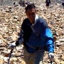
Me. Stayed up at the peak for about 45 minutes
Spikes came on, but I really didn't need them.
Thumbnails for uploaded photos (click to open slideshow):
Caution: The information contained in this report may not be accurate and should not be the only resource used in preparation for your climb. Failure to have the necessary experience, physical conditioning, supplies or equipment can result in injury or death. 14ers.com and the author(s) of this report provide no warranties, either express or implied, that the information provided is accurate or reliable. By using the information provided, you agree to indemnify and hold harmless 14ers.com and the report author(s) with respect to any claims and demands against them, including any attorney fees and expenses. Please read the 14ers.com Safety and Disclaimer pages for more information.
Please respect private property: 14ers.com supports the rights of private landowners to determine how and by whom their land will be used. In Colorado, it is your responsibility to determine if land is private and to obtain the appropriate permission before entering the property.


")
")
")
")
")
")
")
")