Download Agreement, Release, and Acknowledgement of Risk:
You (the person requesting this file download) fully understand mountain climbing ("Activity") involves risks and dangers of serious bodily injury, including permanent disability, paralysis, and death ("Risks") and you fully accept and assume all such risks and all responsibility for losses, costs, and damages you incur as a result of your participation in this Activity.
You acknowledge that information in the file you have chosen to download may not be accurate and may contain errors. You agree to assume all risks when using this information and agree to release and discharge 14ers.com, 14ers Inc. and the author(s) of such information (collectively, the "Released Parties").
You hereby discharge the Released Parties from all damages, actions, claims and liabilities of any nature, specifically including, but not limited to, damages, actions, claims and liabilities arising from or related to the negligence of the Released Parties. You further agree to indemnify, hold harmless and defend 14ers.com, 14ers Inc. and each of the other Released Parties from and against any loss, damage, liability and expense, including costs and attorney fees, incurred by 14ers.com, 14ers Inc. or any of the other Released Parties as a result of you using information provided on the 14ers.com or 14ers Inc. websites.
You have read this agreement, fully understand its terms and intend it to be a complete and unconditional release of all liability to the greatest extent allowed by law and agree that if any portion of this agreement is held to be invalid the balance, notwithstanding, shall continue in full force and effect.
By clicking "OK" you agree to these terms. If you DO NOT agree, click "Cancel"...
The hike started after reaching the upper trailhead. The road was simple for my Tacoma. There was one tricky portion, but I bet a skilled driver in a passenger car could make it up. Or, perhaps my perception is faulty because I drive a truck. At any rate, we made it to the upper trailhead with no issues.
It was brought up that the trail to lower South Colony Lake is only 1.5 miles. Well, that is from the old trailhead app. 2.5 miles further up the old road. This was disappointing once we figured that out. This was of course confirmed when we reached the end of the old road. The road appeared passable in my truck. I was sad I had to hike in so far. Oh well. It will guarantee 3,000 vertical feet for the mountain of my choosing.
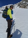
We crossed into the trail, which still looked like a road. Suddenly we could see the sky moving over us. Then we saw lightning and started to hear rolling thunder. The storm was headed in our direction, and we were heading into the storm's direction. Bad combination. Soon it began to rain. We stopped at an outcropping of a bush over the trail and put our rain gear on. The time between the lightning and thunder was decreasing. Flash... (1 one thousand, 2 one thousand, 3 one thousand, 4 one thousand), Bang! The closest lightning was 3.5 seconds away. Depending on the formula used to determine distance, we knew was it was... close! It was over us, and beyond us quickly. However, it was scary, it made us hike faster, and I did not take any pictures during this time. This picture was one of the first views of the needle, just before the storm.
It was around 9 PM when we finally found a good campsite and set up. Luckily the rain had stopped for us. We ate food and decided to hang our food. By then it was after 10 PM and dark. The clouds were keeping any chance of light from reaching us. We had to rely on our own source of lighting. Nate climbed one tree to hang the first side of the rope. We then tied a rock to the other end of the rope and began hurling it over other trees in an attempt to hang our food. After many attempts, and one tree change, we finally had our food hung about 13 feet in the air. We were very impressed with our efforts considering the circumstances, especially the next day when we could see it. We went to bed and arose at 4 AM.
Scott met us at the Crestone Needle marked junction promptly at 5 AM. After pumping some water and tying our food up, we were ready around 5:30 AM. Sorry to have kept you waiting Scott. We began our hike and the sun quickly rose.
The ascent up Broken Hand Pass was uneventful. We must have been tired because I do not remember it seeming so steep. However, looking at it in pictures and from its neighbor Humbolt, it was quite steep. Helmets would not be a bad idea on portions. We met one snow field which was avoided by traveling to the climber's left.
See Nate! This is the portion left of the snow. It was a "fun" alternative.
We gained the pass and caught our breaths.
We laughed at this single glove and the fact that it is named Broken Hand Pass. Imagine the altitude jokes that were funny at 12,000 feet, but may not be funny down in the flat lands. Yes, we enjoyed a good laugh!
We then descended the other side to Cottonwood Lake, which was beautiful. Finding the red gully was simple. The trail takes you right to it... And it is RED! This looked "fun!" We began up the "easy compared to how it looks" red gully. It was wet in spots, but the wet spots were very grippy, if that is a word. As has been reported many times, the red gully looks a lot worse than it really is. However, I wanted to take some scary looking pictures just to show family and relatives.
See Dan and Scott?
The red gully WAS fun. It soon became arduous. It was longer than I anticipated and I was happy to finally reach the saddle.
Nate was first to the top of the gully. I soon followed. Shortly after, Dan and Scott were with us. We had read that the summit was only 200 more feet from that point. With excitement, Nate and I turned right and began to head up Crestone Peak. Scott spoke, "I believe the Peak is to our left. To our right would be East Crestone." Nate and I stopped... Looked at eachother... Looked at Scott. By Golly! I believe Scott is correct. In fact, I had just read that the summit was to the left. We blamed the altitude and began laughing. We were very thankful that we had connected with Scott at this point. Too bad he didn't do the traverse with us. We really could have used some of that mountain wisdom on a few portions. So, we turned left and scurried up to the summit of Crestone Peak.
We only dilly dallied for about 15 minutes and decided to traverse to the Needle! I wish I could give wisdom to people wanting to do the traverse. I had printed trip reports with pictures. Route finding was still difficult at times. It started with the exit from the Red Gully. Did we drop low enough? I have no idea. There was a cairn, but the next one wasn't until 100 feet further down. We kept finding ourselves climbing up a gully, then down the next spotting an occasional cairn. Travel too high and it becomes steep, too low and you may get cliffed out. We also had some swirling fog to contend with. All I can say is, "good luck." Basically, if it becomes too difficult to travel, you are in the wrong place. Backtrack and look for cairns. We backtracked several times which may be the reason for our slow, 3 hour, traverse. The following may not help you at all, but they are some great pictures from the traverse.
With the gendarme coming into view, we knew we were getting close. We found this gully which matched a picture from a trip report. There is a 20 foot rock sticking up in the middle (hard to see in this photo). At the top of this gully was a cairn. Climbing up this gully was likely the best call we made as far as route finding goes.
At the top of the gully the route was becoming much clearer. I had studied several TR on this section. Apparently there are two possibilities. Climb directly over one of the ribs, or stay low and go through the crack. We opted for the safer route and took the (blue) option through the crack.
Looking through the safe crack.
Looking back through the crack at Dan and Nate.
From here we ascended too soon to a notch in the mountain. Was this it? Is this our final summit pitch? Nate and I studied it for a few moments.
It had to be. We followed the routes, but it just looked much steeper than class 4/low 5. I took a few attempts on it and second guessed myself. If this truly is the final pitch, we have to go up. We do not have time to back track all the way to the red gully. I soon found myself halfway up with no more option of backtracking. After finally ascending this wall I was able to finally see the final summit pitch! I climbed too early! This was great news. I did not want to watch Dan and Nate tempt their fates as I had just done. It also meant that the final pitch will not be very scary at all compared to what I had just done. I yelled down, "Do NOT climb this! Head back down the gully and turn left. I will meet you on the other side!"
Looking down waiting for them.
Disclaimer: I will admit that climbing the wall was stupid. I am not proud of climbing it. If I could back, I would not have climbed it. I put myself (and my partners) in danger, which is the last thing I ever want to do on the mountain.
Nate and Dan had a good laugh about my gnarly climb. I quickly became the butt of many jokes on the way down. Nate would point to an inverted cliff and say, "DJ, do you wanna go down that 'fun' way?" I would laugh. As the gullies got steeper, "DJ are you going to just continue down the gully and down climb the cliff at the end?"
We finally found the correct summit pitch. If you end up confused as we did my advice is: it was very clear when we were there. So, if you are not sure, you are probably not there yet. The easiest way up the final pitch was directly on the exposed ridge. This added an element of "fun" to the climb. However, the climbing was not difficult itself. Just take your time to find good holds and don't look down. It goes by quickly.
Looking down at Dan and Nate climbing up the final pitch.
I have never been happier to reach a summit. In the final moments of the traverse, I had moved a 50 lb. rock. It fell down smashing my ankle. I just kept moving in fear that stopping would immobilize my ankle which I needed to finish the climb as well as to get off the Needle. It began to swell, but as long as I was moving, the pain was kept at a minimum. Once on the summit, I just wanted to lay down. So I did. I did not take many pictures, just because I was in pain. I elevated my legs and rested for a moment. The clouds were making us nervous, so we headed down after a few minutes on top. Since we did not ascend the standard needle route, route finding on the descent was problematic. I was so nervous of missing the exit from the west gully to the east gully, that I think we stayed too far left. In fact, I believe we down climbed the class 4 east gully entirely. This is in some route descriptions as "extra credit." We called it the "fun DJ way." We probably traveled back and forth through both gullies actually. Again, probably why it took nearly 3 hours to make it back to camp. Whatever the distance actually is we did about 1.5 times that. However, we were careful. When it was too difficult, we assumed we were in the wrong place and we backtracked.
We eventually saw the well defined trail leading back to Broken Hand Pass. That visual helped as a reference for the correct route finding. Soon we were at BHP looking down. What!! This can't be it! I don't remember it being this steep! It had to be. There were cairns all over. We descended the rotten, steep gully off of BHP and made it to camp unscathed (well... mostly unscathed).
Thumbnails for uploaded photos (click to open slideshow):
Awesome report, DJ! Man, I was so relieved to have texted Nate on Saturday and got the reply back that you guys had success on the traverse. I was getting incredibly worried when I got back to Cottonwood Lake and the thunderheads were building quickly. By the time I got back to Colony Lakes, I saw a group coming down BHP, but it was not you three. I contemplated waiting at your campsite to make sure you guys made it back okay, but I knew I still had the 4 mile hike to get back to the main gate.
In hindsight, I wish I had done the traverse with you guys. Your pictures made it look so cut-and-dry ;) (I know it was much tougher though).
Thanks for inviting me to your group. My only regret is that we all didn't take a summit picture together. You guys were too busy doing headstands Glad to hear you made it back okay... Congrats on a successful traverse!
My buddy and I were down there the day after you with the same intentions. Unfortunately, we got off route and ended up ascending the gully to the middle of the traverse and by the time we finally got over to Crestone Peak, we had wasted a lot of time and energy. We ended up bailing on the traverse with the fear of weather coming in (since we wasted time). Great job on the effort! Loved that area when I was there and cant wait to get back and finish the job!
Scott,
I cannot believe we did not take a summit pic. I mentioned it several times too. It was like turning left to head up the peak. We needed you to guide us into the summit pic. Thanks for the concerns. The weather held out beautifully. It did not rain till around 5 PM.
In my experience, ”fun” is usually an acronym for F'ed Up Nightmare. Awesome climb though. Definitely looking forward to this one. Now I know which way not to go.
Caution: The information contained in this report may not be accurate and should not be the only resource used in preparation for your climb. Failure to have the necessary experience, physical conditioning, supplies or equipment can result in injury or death. 14ers.com and the author(s) of this report provide no warranties, either express or implied, that the information provided is accurate or reliable. By using the information provided, you agree to indemnify and hold harmless 14ers.com and the report author(s) with respect to any claims and demands against them, including any attorney fees and expenses. Please read the 14ers.com Safety and Disclaimer pages for more information.
Please respect private property: 14ers.com supports the rights of private landowners to determine how and by whom their land will be used. In Colorado, it is your responsibility to determine if land is private and to obtain the appropriate permission before entering the property.


")
")
")
")
")
")
")
")
")
")
")
")
")
")
")
")
")
")
")
")
")
")
")
")
")
")
")
")
")
")