Download Agreement, Release, and Acknowledgement of Risk:
You (the person requesting this file download) fully understand mountain climbing ("Activity") involves risks and dangers of serious bodily injury, including permanent disability, paralysis, and death ("Risks") and you fully accept and assume all such risks and all responsibility for losses, costs, and damages you incur as a result of your participation in this Activity.
You acknowledge that information in the file you have chosen to download may not be accurate and may contain errors. You agree to assume all risks when using this information and agree to release and discharge 14ers.com, 14ers Inc. and the author(s) of such information (collectively, the "Released Parties").
You hereby discharge the Released Parties from all damages, actions, claims and liabilities of any nature, specifically including, but not limited to, damages, actions, claims and liabilities arising from or related to the negligence of the Released Parties. You further agree to indemnify, hold harmless and defend 14ers.com, 14ers Inc. and each of the other Released Parties from and against any loss, damage, liability and expense, including costs and attorney fees, incurred by 14ers.com, 14ers Inc. or any of the other Released Parties as a result of you using information provided on the 14ers.com or 14ers Inc. websites.
You have read this agreement, fully understand its terms and intend it to be a complete and unconditional release of all liability to the greatest extent allowed by law and agree that if any portion of this agreement is held to be invalid the balance, notwithstanding, shall continue in full force and effect.
By clicking "OK" you agree to these terms. If you DO NOT agree, click "Cancel"...
13580 is the easiest peak in the Willow Creek basin I hadn't hiked. I've been planning on this one for a while, but had to keep putting it off this year due to repeated visits to national parks and a mild knee injury in early June. Then the area became unusably smokey from the West Fork fire, and then the mosquitoes came in. This day and the following one were forecast as the least monsoon-like of the month, making it a no-brainer to head up. Keifer put out feelers for a more ambitious hike in the same area, but it sounded just a bit too ambitious for me.
Beta for 13580 itself turned out not really to be necessary; the hike to this peak was incredibly easy (in a technical sense) with no routefinding issues beyond the swampy willows. Good trip reports exist by both Kevin Baker and Furthermore, though both of them skim over the 13580-Adams ridge which I was interested in. The route up the northwest slopes of 13580, not mentioned in any reports I could find, is shown almost in its class 2 entirety in the views from 13546 across the basin. The route - seen from 13546 Ambitious topo map
Willow Lake
Starting from the alternate trailhead in the Baca Grande (which seems to have become a lot more popular since the month-long closure of the public trailhead), I headed straight and promptly up the trail - passing two groups of six people total on their way up for an overnight at the lake. The approximate halfway point is a distinctive spot where the trail switches back, then immediately takes a 90 degree cut to the right and back. I stopped here for a few minutes during which a helicopter flew overhead as part of the search for Mike Cormier. Helocoptor overhead
In crossing the headwall, I passed the lone descending hiker of the day. He had been up at the lake taking pictures, and I told him to watch as he descended the headwall since you can often see pikas there. These not-so-elusive rodents more often live above treeline, but the rocky area along this headwall is perfect for them. Humorously then, about fifteen seconds after the photographer continued his descent, a pika came out of the rocks just a few feet from me and started screaming the pika scream. We yelled at each other for a few minutes before I moved on. Camo pika on the headwall
It seemed like the hundredth time I've been up to Willow Lake, but it was certainly the fastest: 2:02 from the alternate trailhead fork to the campground. It didn't feel like I was pushing too hard, but in light of later elevation issues it might have been so.
Upper basin
From the lake I headed left up the slope, a route I had taken several times before. If you cut left too early, you risk getting diverted back to the west by some boulders, causing tedious bushwhacking. If you cut left too late, you end up getting pushed back to the correct spot by an obvious cliff. I took the conservative route and cut left too late, just before the boulder and willow area that must be crossed to continue up toward Challenger. Obligatory lake picture
From above the lake there are some route finding issues, as willows (at least, I think that's what they are) impede progress. I cut to the left and followed along the top of the gully cut by the stream. To climb Adams, 13546, or 13151 (the next ridge over) one would continue to the obvious saddle straight ahead. To get to 13580 though, I needed to loop back around to the right. This entailed going through even more willows, and around a swampy tarn. As willows go, these are pretty thin and it was not hard to find a path through them. Swampy tarn - blame this for the mosquitos
Much has been made of the mosquitoes in the area, but this is incorrect. There are a few mosquitoes, and if you were camping there would certainly be a risk of being eaten, but compared to previous years (2010 comes to mind) there are many orders of magnitude fewer this year. Oddly, this area above tree line (but below willow line) had the worst of them. This is odd because I usually don't find mosquitoes above treeline; however, this area is also quite swampy and is no doubt a breeding pool for them. It was also getting cooler up here, so I put on my long pants and sleeves.
Northeast slopes
This grand name pretty well covers an entire quarter of the mountain that makes for an easy route up. Looking at this from 13546, it looked pretty talus-covered; however, much of it turned out to be grassy and the areas that were rock were surprisingly stable. The stability was probably due to the lower-than-expected grade of the slope, that was only about 30 degrees most of the way. Just about any route up this circular basin will be an easy class 2, but staying to the right and heading up to the ridge gives the most tundra hiking and then better views the rest of the way up.
Looking up through the lower area of the "slopes" Looking down at the swampy area and Pt13546
Leaving the swampy willow area then, I first headed up a wide gully of rocky tundra. Several small creeks flowed down this scenic gully. Higher, things did turn to talus and I generally kept toward the right - although in hindsight, not as much as I should have. In a perfect world, one can just follow a narrow arc from the swampy upper basin toward the saddle along the west ridge, but my route diverged slightly from this both going up and going down. Further, the topo map isn't particularly accurate and does not show this saddle in the correct place. In short, the route I took down (as seen in the GPS track) was more efficient than the one I took up.
Unfortunately, although my pace up to this point had been quite fast, I was now hitting the "curse of 12000" wall. Though I've done a lot of hiking this summer, not much has been at high elevation and it was getting to me - along with the 3500 feet I'd already climbed, no doubt. I had been planning to save my lunch for the first summit, but feeling hungry (not really a sign of AMS!) and low on energy ended up eating it much sooner.
Middle segment of slopes Another look across at 13546
At a convenient-looking spot I started cutting further to the right, eventually bringing me up to the top of the peak's western ridge. This was even easier hiking, and with views down over the Willow Creek basin I quickly wished I'd cut up to this ridge sooner. I saved most of my picture-taking for the summit however.
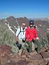
Summit
Like most peaks above tree line, the summit was amazingly beautiful. Excellent views of Challenger, Kit Carson, Columbia, Crestone Peak, Crestone Needle, and Humboldt were to be expected, but the narrowness of the peak also gave great views down into the creek basins on both sides. A small plastic jar hidden in the summit cairn contained a summit register, which only went back to 2010 and included about 10 people per year. This angle did give a particularly good view of Challenger, just across the basin. Where is waldo? 13564, 12740, and Adams Willow Lake Intimidating view of Challenger Looking east
Adams
The original plan was to traverse across to Mt Adams. Shortly after getting to the summit, I decided to call that off. There were several reasons for this, starting with my moderate level of fatigue. Secondly, the descent from the Adams-13580 saddle didn't look as benign as I would hope (it appeared steep, loose, and occasionally cliffy), making a solo descent if I turned around either a bit risky, or tedious if I returned most of the way to 13580. Thirdly, the ridge just looked more intimidating than I had expected, and I realized I hadn't gotten quite as much beta on this part of the climb as I should have. With the ongoing SAR activity in the basin below me I was more conservative than I probably would have been otherwise. Adams-13580 saddle
However, this instead gave me the opportunity to hang out on the summit for 91 minutes. In hindsight, it was an excellent decision. I may impose a future 60-minute minimum on all my summits (weather permitting). My only regret is that I didn't take enough food and water to spend all afternoon there and hike down in the full moon.
I did snap one other interesting photo of the Adams summit. From this unusual angle you can see all the difficulties in the "standard" west ridge approach: the false summit block (left), actual summit block (middle), and then the class 3 gully leading up to the notch.
It appeared as if there was no easy way to traverse around to 13546; one must either go almost all the way to the top of Adams or descend all the way back down. Therefore, a true "tour de Adams" would probably go up Willow Creek trail, to 13580, up the ridge to Adams, down the W ridge to 13546, then traverse around to 13153, and out via South Crestone Creek. 13153 and 13546 could be swapped, and the whole thing could be done in reverse order; the Adams south ridge is probably the technically hardest part.
Descent
The descent was uneventful; however it afforded the opportunity to throw on a few extra (dare I say excessive?) pictures.
I did pass between 25 and 35 people headed up to camp and summit Challenger the next day. I have no idea how many of them succeeded, but they certainly got a good day of weather for it.
Conclusion
This was an extremely easy route from a technical perspective, although it is a net +4700 feet which is fairly long for a single summit. It's a much shorter hike from the lake (+2000 feet). Further, the route lacks any exposure at all (there is exposure from the summit). It would be an excellent morning hike for any dragged up to the lake to camp, who does not wish to summit Challenger.
BTSync secret for full set of images: BFYSV67AICEMTFPKXX7VXQPSVACB7DO5I
My GPS Tracks on Google Maps (made from a .GPX file upload):
Thanks for this. I ran out of time and ran into some difficulties trying to run from Adams to 580 a few years back. But Willow Lake is one of those special places in CO so I won't mind making another visit.
And I greatly appreciate your western sangre condition updates. Thank you for those as well.
I came up Horn Creek TH to Adams to 580A back to Adams to TH the day before. The traverse between Adams/580A was much easier on the way back. I stayed too high descending from Adams to the saddle and ended up doing a fair amount of scrambling, with a little class 4 just before the saddle. Then it was mostly grass and solid small talus from the saddle to 580A. On the way back I aimed to cross ~75 feet below the saddle (obviously on the West side) and ended up only needing to do a couple of easy class 3 moves, while connecting grassy ledges all the way to Adam's Summit.
It sounds like the Adams south ridge wasn't as hard as I thought, but presented just about as many route finding challenges as it looked like it would present. So, good choice to bail on it...for now.. The mistake was not getting more beta on that ridge from other TR authors.
I found it odd none of the trip reports for 13580 (there are quite a few) included this route...they all traverse from Adams and 13517. This would be expected for Kevin Baker and Furthermore, but several other reports covered a descent from Adams, crossing 13580, and continuing toward 13517 before bailing down class 3/4 slopes. It didn't seem efficient.
In looking at 13er routes, I start with trip reports, then look at topo maps, and finally at pictures from adjacent peaks. I suppose asking people might come in handy too.
Side note, I read that all three 13580's are tied for the #200 (or maybe #199) spot.
P.S. The day before!? I think I would have noticed that in the register.
I don't always sign the registers, but I did sign both that Sunday. The 13580 register was a small plastic container, like a cleaned out plastic peanut butter container, with a bunch of plain white paper torn in quarters. I didn't see a sheet with any 2013 dates (although I didn't look too hard), I started a new sheet.
Regarding the 3-way tie at 13580...Matt Payne has an interesting take on it in his Adams trip report (his opinion differs from Roach's). I assume Roach sorted by the crazy geological survey heights that go to the third decimal point...even though many were surveyed 50 years ago and can be off by several feet!
Yeah I remember the newly started sheet. Those registry papers were a mess. Guess the altitude got to me...
Matt's method is to use prominence as the #2 criteria (after elevation), however, this is definitely off by more than a few feet since almost all peaks have interpolated prominence.
Last year I had my own (mis)adventure on Pt 13,580A - mostly, I couldn't seem to figure out how to get there from Willow lake (my primary goal was Mt. Adams though). Your report is very helpful in describing a viable alternative. Since Pt 13,580A is a ”bi”, I see myself going back at some point. Finally, Images #16-17 show my descent route off Adams - umm, loose stuff of the nightmares - definitely don't recommend it.
Caution: The information contained in this report may not be accurate and should not be the only resource used in preparation for your climb. Failure to have the necessary experience, physical conditioning, supplies or equipment can result in injury or death. 14ers.com and the author(s) of this report provide no warranties, either express or implied, that the information provided is accurate or reliable. By using the information provided, you agree to indemnify and hold harmless 14ers.com and the report author(s) with respect to any claims and demands against them, including any attorney fees and expenses. Please read the 14ers.com Safety and Disclaimer pages for more information.
Please respect private property: 14ers.com supports the rights of private landowners to determine how and by whom their land will be used. In Colorado, it is your responsibility to determine if land is private and to obtain the appropriate permission before entering the property.


 The route - seen from 13546")
 Ambitious topo map")
 Helocoptor overhead")
 Camo pika on the headwall")
 Obligatory lake picture")
 Swampy tarn - blame this for the mosquitos")
 Looking up through the lower area of the \"slopes\"")
 Looking down at the swampy area and Pt13546")
 Middle segment of slopes")
 Another look across at 13546")
 Where is waldo?")
 13564, 12740, and Adams")
 Willow Lake")
 Intimidating view of Challenger")
 Looking east")
 Adams-13580 saddle")
")
")
")