Download Agreement, Release, and Acknowledgement of Risk:
You (the person requesting this file download) fully understand mountain climbing ("Activity") involves risks and dangers of serious bodily injury, including permanent disability, paralysis, and death ("Risks") and you fully accept and assume all such risks and all responsibility for losses, costs, and damages you incur as a result of your participation in this Activity.
You acknowledge that information in the file you have chosen to download may not be accurate and may contain errors. You agree to assume all risks when using this information and agree to release and discharge 14ers.com, 14ers Inc. and the author(s) of such information (collectively, the "Released Parties").
You hereby discharge the Released Parties from all damages, actions, claims and liabilities of any nature, specifically including, but not limited to, damages, actions, claims and liabilities arising from or related to the negligence of the Released Parties. You further agree to indemnify, hold harmless and defend 14ers.com, 14ers Inc. and each of the other Released Parties from and against any loss, damage, liability and expense, including costs and attorney fees, incurred by 14ers.com, 14ers Inc. or any of the other Released Parties as a result of you using information provided on the 14ers.com or 14ers Inc. websites.
You have read this agreement, fully understand its terms and intend it to be a complete and unconditional release of all liability to the greatest extent allowed by law and agree that if any portion of this agreement is held to be invalid the balance, notwithstanding, shall continue in full force and effect.
By clicking "OK" you agree to these terms. If you DO NOT agree, click "Cancel"...
Route: Columbia West Slopes > Traverse > Harvard South Slopes
Date: Friday, July 26, 2013 - Saturday, July 27, 2013
Party: Rohit and Mike
Times: Left camp, .5 miles below junction: 0400
Summit of Columbia: 0625
Left Columbia: 0645
Summit of Harvard: 0930
Left Harvard: 1000
Back at camp: 1122
Left camp: 1144
Back to car: 1244
Total hike time car to car (not including sleeping) : 9 hours 45 minutes
Friday, July 26
Rohit and I drove into Buena Vista around 8 PM and stopped at Subway to get a last minute calorie burst before making our way up to the trailhead. The road was very easy to drive on and we found a parking spot by 9 PM. I was really surprised to see so many cars in the lot. The place was full already and it didn't even include the people that were going to make a day hike! We geared up, made sure we had everything, and started the trek to our camping destination. We intended on sleeping right at the junction of where the Columbia trail meets the standard Harvard route, but unfortunately, we didn't quite hike in far enough and fell about a half mile short of our target.
Entering the wilderness
Headed up to camp
After about 1 hour and 15 minutes, we found an area that we decided would be a good place to set up camp. 10 minutes later, we had the tent up and sleeping pads / bags all set up and ready to go. We took a brief trip down to the stream to pump / treat water for the upcoming hike so that we could roll out of bed and hit the trail. Somewhere around 11:30, we were in the tent and trying to get some sleep for the day ahead of us!
Saturday, July 27
We woke up at 330 AM to the sound of the alarm clock on my phone, not a very pleasant sound when you haven't slept much. It's hard to say how much sleep I got, but I know I got a little since I distinctly remember having a dream. We both threw on our clothes and started eating breakfast. By 4, we were starting up the trail on our way to Mt. Columbia.
It didn't take very long to reach the West slopes of Mt Columbia. We were making good time so far but that progress ground to a halt as we lost the trail and were ascending through a scree filled gully that would essentially move out from under your boots. It was literally like walking up a very steep sand dune. I looked at the route description and figured that we had to make our way up and to the right of where we were. Gradually, the rocks became bigger and more stable and soon we popped out on top of the ridge, just in time to witness a great sunrise!
Scene from the Lion King?
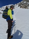
Rohit at sunrise
We watched the sun come up for a while and then made our way over to the summit of Columbia. It only took 20 more minutes and before we knew it, we were all alone on the summit. All of the other hikers that we encountered that day went to Harvard first. Having just came up that way, I had to laugh at what they were going to have to descend through. We spent 20 minutes on the summit, having some rum, getting our summit photos, texting loved ones, and planning our assault on the ridge to Harvard.
Obligatory summit photo
MMmmmm rum
The ridge
The traverse seemed pretty straight forward, especially after reading a great trip report that described this direction of the ridge extremely well. We started off by going straight down the northern face and made our way to the flat spot just below us. We quickly were able to identify some key landmarks and we made a plan on how we wanted to attack the boulder filled course in front of us.
Look at the ridge and the route we took
We had a great time crossing these boulders and before we knew it, the fun was over and we were making our way up the grassy shoulder towards the false summits of Harvard.
Rohit on the ridge
Me with Harvard in the background
On the way up the shoulder, we were able to see great views of the weather coming and also at the hoards of people on top of Harvard. We made our way up past the false summits and all of the elevation gain to reach a ridge just off of the summit. A moment later, we topped out on top of Harvard, 5 and a half hours after we left our camp!
Summit of Harvard
More summit alcohol and pictures ensued and before we knew it, we were making our way down Harvard's standard route. Just as we were hitting our stride down the mountain, we were blocked by a threesome of goats. I found it interesting that there was a single person standing in the trail, and as a goat approached, the person had a look of "I want to pet you". I recall a trip up Quandary where a goat crossed my path and as it looked at me, it stomped its hoof as if to say "bring it". After that experience, I pretty much figure that all goats will do that and steer clear, opting to take pictures from a distance, but alas, this person stood very still and was very close to this goat. The person had more guts than I do, that's for sure.
Close goat...
After we got passed the road block, it was pretty smooth sailing all the way back to camp. We took some great pictures from within the basin, which I have to say is among the prettiest I have seen so far!
Wildflowers.
Once we arrived at camp, we were in a huge hurry to get it all packed up. The once pleasant campsite that we had the night before was now overrun with a population of mosquitoes that would rival the number of citizens of China! Their barrage was relentless and drove us to an accelerated pace out of the area! Fortunately, I was able to avoid too many bites since I really only had to protect my neck and arms. We left the old campsite and made our way down the trail towards the car and freedom from the mosquitoes.
As we approached the trailhead, we noticed that the weather up in the basin (blocked by some mountains) had taken a turn for the worse. Just as we reached the car and opened the door, the sound of thunder filled the air. Talk about perfect timing!
Storms coming in
This hike was one of the most fun routes I have done and definitely one of the crown jewels of the Sawatch range. With only Princeton and Antero left in this range, I don't see this route being uprooted from my top spot. With the great bouldering and amazing views, this will surely be a route that I would do again in a heartbeat! I really feel that the Columbia to Harvard direction is the way to go and would recommend it to anyone! Not only do you get a good visual of the route ahead of you, there is also NO SCREE to descend through at the end of a tiring day! These mountains are truly a gem and I can't wait to do them again!
Wildflowers on the ridge.
Thumbnails for uploaded photos (click to open slideshow):
Terrible Towel? . . . Good Grief! 7/29/2013 11:29pm
Just what this site needs--another yinzer. You should p.m. Stiffler_from_Denver so you can talk about Primanti Bros. and all else Pittsburgh. I myself can't wait to see the Pirates go from 1.5 games behind now to 23 games behind by the end of August.
Nice work on the traverse though! At least you have that going for you. That was a good call to do the lower peak first--certainly saves you from descending nasty scree on Columbia.
I was born north of Pittsburgh so I have to show my roots from time to time. As for your pirates reference, I dont really care about them since I dont watch baseball. I figure its best to stay true to your roots though as opposed to being one of those flip-floppers that root for whoever is convenient! Besides, its hard to argue with 6 super bowls...
Yeah man, that traverse is AWESOME and going from Columbia to Harvard has another nice advantage of being able to see all of your route before you commit! The fact that we didn't have to hit that scree on the way down... added bonus!
this route about a month ago and we went up Columbia and down Harvard. I second that is definitely the way to go. It is also much more environmentally sound. Nice trip report and good time. Took us 15 hours but we started from the TH, never found the correct trail while ascending Columbia (we ended up scrambling through the woods and up a fairly long class 3/4 cliff band), and descended too far off Columbia. It was one of my favorite days too
My husband and I must have seen you sometime this day. I don't recall seeing you on the summit of Harvard but we were up there around 9:30 as well on Saturday with the mass of people. Maybe we started descending just as you summited? We descended before the large high school group left the summit. We got back to our car at the TH around 1pm or so I think so I wonder if you passed us at some point. It was a great day, until those dark clouds rolled in! We just barely missed the rain too - lots of people were still heading up.
I probably passed you guys on my way up Saturday afternoon. I spent the night just below tree line on Saturday with plans to summit Columbia on Sunday morning. Unfortunately steady rain from about noon on Saturday through the entire night made me postpone those plans. I also got attacked by the mosquitos (probably near where you camped) and am still doing plenty of scratching. Congrats on the climb, great photos.
Caution: The information contained in this report may not be accurate and should not be the only resource used in preparation for your climb. Failure to have the necessary experience, physical conditioning, supplies or equipment can result in injury or death. 14ers.com and the author(s) of this report provide no warranties, either express or implied, that the information provided is accurate or reliable. By using the information provided, you agree to indemnify and hold harmless 14ers.com and the report author(s) with respect to any claims and demands against them, including any attorney fees and expenses. Please read the 14ers.com Safety and Disclaimer pages for more information.
Please respect private property: 14ers.com supports the rights of private landowners to determine how and by whom their land will be used. In Colorado, it is your responsibility to determine if land is private and to obtain the appropriate permission before entering the property.


 Entering the wilderness")
 Headed up to camp")
 Scene from the Lion King?")
 Rohit at sunrise")
")
 Obligatory summit photo")
 MMmmmm rum")
 The ridge")
 Look at the ridge and the route we took")
 Rohit on the ridge")
 Me with Harvard in the background")
 Summit of Harvard")
 Close goat...")
 Wildflowers.")
")
 Storms coming in")
 Wildflowers on the ridge.")