Download Agreement, Release, and Acknowledgement of Risk:
You (the person requesting this file download) fully understand mountain climbing ("Activity") involves risks and dangers of serious bodily injury, including permanent disability, paralysis, and death ("Risks") and you fully accept and assume all such risks and all responsibility for losses, costs, and damages you incur as a result of your participation in this Activity.
You acknowledge that information in the file you have chosen to download may not be accurate and may contain errors. You agree to assume all risks when using this information and agree to release and discharge 14ers.com, 14ers Inc. and the author(s) of such information (collectively, the "Released Parties").
You hereby discharge the Released Parties from all damages, actions, claims and liabilities of any nature, specifically including, but not limited to, damages, actions, claims and liabilities arising from or related to the negligence of the Released Parties. You further agree to indemnify, hold harmless and defend 14ers.com, 14ers Inc. and each of the other Released Parties from and against any loss, damage, liability and expense, including costs and attorney fees, incurred by 14ers.com, 14ers Inc. or any of the other Released Parties as a result of you using information provided on the 14ers.com or 14ers Inc. websites.
You have read this agreement, fully understand its terms and intend it to be a complete and unconditional release of all liability to the greatest extent allowed by law and agree that if any portion of this agreement is held to be invalid the balance, notwithstanding, shall continue in full force and effect.
By clicking "OK" you agree to these terms. If you DO NOT agree, click "Cancel"...
This was my second venture over Music Pass into Sand Lakes Basin, the first years ago when Tijeras rebuffed my late season effort. This time, with my daughter, son, and fellow Arkansan Mark L. in tow, and stable weather above, I enjoyed a fun scramble leading to sweeping views of the Sangres. There have been some excellent recent TR's covering this fine peak, so find here an abbreviated report with a few photos that may be of help to those considering the climb. Next my daughter and I hiked up to Milwaukee Pass where we admired the peak's exposed crux and stunning views of Broken Hand, the Crestones, Cottonwood drainage, Pico Aislado, Marble Mountain, Humboldt Peak, Music Pass and on and and on and on...
Tijeras Peak
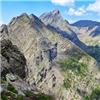
Tijeras above Lower Sand Creek Lake
We left the north shore of Lower Sand Creek Lake and hiked NNW to the lower slope of Music's East Ridge which we paralleled until well up the basin. There we turned south and found easy willow-free going across the basin to the Tijeras-Music cliff band. I've been in both ramps. The "left" ramp is lower in the basin, easier to locate, shorter, steeper, and the approach more guarded with willows. The "right" gully is further west up the basin than one might think, approx. a half mile along the cliff band from the lower ramp, and can be difficult to see in certain light. It is longer, less steep, looser than the "left" ramp and might be more properly called a gully. We opted to ascend and descend the "right" ramp. From the top of the ramp we hiked west up gentle grassy slopes to the Tijeras-Music saddle then followed the ridge proper to the summit. A small notch near the summit can be easily skirted to climber's right. In this shot the "left" ramp is directly below the summit. The main ramp is out of frame to the right.
Main access ramp.
From the base of the main ramp along the cliff band to Music Mountain.
Scooting up the main ramp.
Fun scrambling near the summit.
Summit view south with the Blanca Group in the distance.
North to Muisc, Milwaukee, the Crestones. And a hero.
Above acccess ramp: Lower Sand Creek Lake and Music Pass.
Milwaukee Pass
On day two, my daughter and I hiked to Milwaukee Pass via the Cottonwood Pass Trail which we picked up below Upper Sand Creek Lake. The route led us into the beautiful basin below Milwaukee and Unnamed 13,161'. From the sweeping Milwaukee-13,161' saddle which overlooks South Colony, the trail to Milwaukee pass is strong and well-maintained. (recent work of the CMC?) This is an enjoyable day hike from either of the Sand Creek Lakes. The views from the ridge to Milwaukee Pass are spectacular: Broken Hand Peak and Crestone Needle on full display. Milwaukee Pass itself puts one right close to the crux ledges and just 150' below the peak's summit. The Cottonwood drainage and Milwaukee-Pico Aislado connecting ridge are also in plain view from the pass. A sweet spot indeed.
Arching ledges and roofs below Milwaukee's Northeast Face.
Aim for the saddle, turn left.
From the saddle - Broken Hand Peak and Crestone Needle.
From the saddle back toward to Sand Creek Lakes and Music Pass.
Broken Hand Peak
Looking back into the Sand Lakes area with Marble and Music Pass beyond.
Looking up to the pass and Milwaukee's summit (l) and exposed ledge pitch.
The connecting ridge to Pico Aislado.
West into the Cottnwood drainage.
Hannah waiting on the ridge below.
From Milwaukee Pass to Music Pass.
Back down into the basin.
Team Arkansas.
Thumbnails for uploaded photos (click to open slideshow):
Glad you enjoyed the photos.
We had the whole basin to ourselves for nearly three days. Both lakes make for great bases from which to explore the surrounding peaks.
Caution: The information contained in this report may not be accurate and should not be the only resource used in preparation for your climb. Failure to have the necessary experience, physical conditioning, supplies or equipment can result in injury or death. 14ers.com and the author(s) of this report provide no warranties, either express or implied, that the information provided is accurate or reliable. By using the information provided, you agree to indemnify and hold harmless 14ers.com and the report author(s) with respect to any claims and demands against them, including any attorney fees and expenses. Please read the 14ers.com Safety and Disclaimer pages for more information.
Please respect private property: 14ers.com supports the rights of private landowners to determine how and by whom their land will be used. In Colorado, it is your responsibility to determine if land is private and to obtain the appropriate permission before entering the property.


 and exposed ledge pitch.")


 Tijeras above Lower Sand Creek Lake")
 In this shot the \"left\" ramp is directly below the summit. The main ramp is out of frame to the right.")
 Main access ramp.")
 From the base of the main ramp along the cliff band to Music Mountain.")
 Scooting up the main ramp.")
")
 Fun scrambling near the summit.")
 Summit view south with the Blanca Group in the distance.")
 North to Muisc, Milwaukee, the Crestones. And a hero.")
 Above acccess ramp: Lower Sand Creek Lake and Music Pass.")
")
 Arching ledges and roofs below Milwaukee's Northeast Face.")
")
 Aim for the saddle, turn left.")
 From the saddle - Broken Hand Peak and Crestone Needle.")
 From the saddle back toward to Sand Creek Lakes and Music Pass.")
 Broken Hand Peak")
 Looking back into the Sand Lakes area with Marble and Music Pass beyond.")
 Looking up to the pass and Milwaukee's summit (l) and exposed ledge pitch.")
")
 The connecting ridge to Pico Aislado.")
 West into the Cottnwood drainage.")
 Hannah waiting on the ridge below.")
 From Milwaukee Pass to Music Pass.")
")
 Back down into the basin.")
 Team Arkansas.")