Download Agreement, Release, and Acknowledgement of Risk:
You (the person requesting this file download) fully understand mountain climbing ("Activity") involves risks and dangers of serious bodily injury, including permanent disability, paralysis, and death ("Risks") and you fully accept and assume all such risks and all responsibility for losses, costs, and damages you incur as a result of your participation in this Activity.
You acknowledge that information in the file you have chosen to download may not be accurate and may contain errors. You agree to assume all risks when using this information and agree to release and discharge 14ers.com, 14ers Inc. and the author(s) of such information (collectively, the "Released Parties").
You hereby discharge the Released Parties from all damages, actions, claims and liabilities of any nature, specifically including, but not limited to, damages, actions, claims and liabilities arising from or related to the negligence of the Released Parties. You further agree to indemnify, hold harmless and defend 14ers.com, 14ers Inc. and each of the other Released Parties from and against any loss, damage, liability and expense, including costs and attorney fees, incurred by 14ers.com, 14ers Inc. or any of the other Released Parties as a result of you using information provided on the 14ers.com or 14ers Inc. websites.
You have read this agreement, fully understand its terms and intend it to be a complete and unconditional release of all liability to the greatest extent allowed by law and agree that if any portion of this agreement is held to be invalid the balance, notwithstanding, shall continue in full force and effect.
By clicking "OK" you agree to these terms. If you DO NOT agree, click "Cancel"...
If you've driven over Monarch Pass from Gunnison to Salida in clear day time weather...you've seen this amazing peak and couloir!
Mount Aetna 13,745 (BiCentennial)
Taylor Mountain 13,651 (BiCentennial)
Several years ago, my climbing friend Steve Gladbach suggested we go climb Mt. Aetna. Back then I was focused on a different list and wasn't interested. However, after a hut trip last December at the foot of Aetna, this peak came into my sights. After talking with Ken Nolan about it, he mentioned that THE GRAND COULOIR on Mt. Aetna was his favorite snow climb in the state. That sealed the deal for me. I'm going for a spring snow climb of THE GRAND!
The trailhead for these BiCentennial peaks is right at the snowmobile rental shop on Hwy 50 which is labeled on maps as Garfield, CO. The signs on the road now call it Monarch. This rental shop is just west of that big Monarch Lodge building but on the opposite (north) side of the highway. If coming from the east, it is approximately 13 miles west of Poncha Springs, the junction of Highways 50 & 285. If coming from the west, it's about 3.5 miles east, down the pass, from Monarch Ski Area. Just to the left (west) of the rental shop, is FS230. In the summer you can drive up this road, in the winter, you park just beyond the rental shop, along the road heading west. Pull way over as to not block the snowmobile path.
Our current trip was in May, so some of this road had melted out and we were able to drive up .4 mile and the steepest part of the road. Yay!
Our plan was a do a clockwise loop for these two peaks. (See map at end of report.) Route finding is quite easy as you are hiking the FS230 road approximately 2.5 miles up the Middle Fork of the North Arkansas river drainage.
In the winter, the snow is usually packed by the snowmobiles, which is a nice plus! The photo below is of Candice back in December when we hiked this same road for a hut trip to the Lost Wonder Hut. Great time by the way!
Our trip was in May, and the track was still in. Eventually, you start to come out of the trees and things open up. First light and a moon.
Mike and Sarah gander up, getting a first look of our goal.
Tight shot of the upper couloir.
It becomes quite obvious that you are at the foot of THE GRAND COULOIR! It comes right down to the forest service road.
Let the climbing begin! Mike and Sarah start up the 3,000 foot (almost) snow climb...THE GRAND COULOIR. Where the couloir starts at the road the elevation is 10,800. The top of Aetna is 13,745. So, it's close enough to round this number up to 3k.
This bottom section is kind to us....the ramp-up is not to bad. (photo by Sarah Simon)
It doesn't take long to realize, it is a loooong ways to the top of this thing!
As we start approaching the trees on the right, the slope angle is ramping up.
Mike is making good time as he nears the halfway point and the first rays of sunshine are hitting the top left of the couloir. Isn't there something about those rays of sunshine that just bring encouragement?
Looking back at Clover Mountain (12,955) which is enjoying the morning sunlight. The moon is dropping and Sarah is making her way up.
Compare the size of that ridge cornice to the size of Mike way below it. That is a monster cornice!
A little further up, Mike approaches the evidence of a slide.
Looking back again over to Clover Mountain and Bald Mountain...both 12ers on the other side of the Middle Fork.
During our climb up the snow, Mike dropped his mittens. Crap!...they are sliding to the bottom of this huge snow slope! I saw them coming down and ran out into the middle of the couloir to cut them off. I was successful in the retrieval and so Mike came down to me for them, and then continued on down to Sarah to encourage her, as she was dragging today. (What a good guy.) That's how he ended up below me and back with Sarah. You can see evidence of the snow slide again.
Selfie in THE GRAND COULOIR.
A ways to go...and it's getting steeper.
A wide shot reveals Mount Ouray off to the south...which by the way, is a great Centennial climb!
As you can see the slope angle is ramping up over 40 degrees. And yet, while it's been getting steeper, the snow has been very stable. We had a big spring snow storm hit 4-5 days earlier, but with enough sun to encourage the spring freeze-thaw cycle.
Looking back down this massive snow slope.
There's still a ways to go to reach the top of this incredibly long couloir climb. And it was at this point that the snow consistency began to change.
As I got to the last 100 vertical feet to the ridge, the top layer of 6-8" began sluffing off with each step. With the vertical slope angle, it was a bit un-nerving. So, I moved into a two-handed, self-belay movement with my ice axe. While, I had an axe and could self-arrest, I didn't have any desire to chance it.
I kinda figure about 1mph for steep climbs, and this turned out to be just about that as it's 1.1 miles from road to ridge top. We started climbing up the couloir at 6:23am. And, just keeping a moderate pace, I topped out at 9:25am. 3,000 vertical feet=3 hours. The summit is just a short jaunt over there.
Wow! What a view. From R to L, the highpoints are Shavano, Tabeguache, Antero, Cronin (super white), Princeton (in the distance).
I made my way over to the summit to find a place to hunker down out of the wind. A short time later, up come Mike and Sarah.
Mike, just below the ridge. He makes it up and then...
Sarah reaches the ridge with that $#!+, that was tough!" look.
Now, that we are all on the ridge, time to make our way over to the summit.
Sarah, celebrates a new summit with a little summit planking!
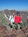
Yeppers....we did a summit selfie.
Mike starts heading over to Taylor, which is about 1.1 miles away.
But before making the trek, Mike waves his US flag from upon high.
On the downhill off of Aetna, we get some glissade time. I was happy to see Sarah give it a go, as she's had a past bad experience glissading with an axe!
We made it down to the saddle in no time. Now it's time to reclimb some lost elevation.
But before heading up, we look back at Aetna that we had just descended. She's a beauty!
Time to climb up to that false summit. It looks pretty pointy from down here. I was hoping it doesn't loose a bunch of elevation on the other side.
Yay! No elevation loss after crossing over the false summit.
The obligatory summit selfie.
We descended off of Taylor heading down the southwest ridge. Our route would take us down into the cirque between Aetna and Taylor to Hoffman Park, shown on most maps. It's down in the trees right at treeline. We ended up dropping off of the ridge into the cirque to soon and ended up on some steep and loose terrain. My suggestion, it to take the ridge down almost to treeline before turning right and down into the cirque. See map below.
Thanks Ken Nolan for your hearty endorsement of this snow climb. THE GRAND COULOIR doesn't disappoint! What a great day with great partners.
God is good!
Thumbnails for uploaded photos (click to open slideshow):
We did this loop a month ago in the opposite direction. We ascended Taylor using FR 228 (Taylor gulch) - it is very straightforward and was the easiest part of the loop for us. In fact, the fastest person in our party made it to the top of Taylor in 2 hours, and it took me about 3 from leaving the parking lot. Cannot recommend this approach enough - and you get to see the stone quarry about half-way. We then traversed the ridge to Aetna, but instead of skiing Grand, we skied the SE face of Aetna, which put is in the basin between Taylor & Aetna. It was very doable on skis but I cannot see how it can be fun on 'shoes. Fun trip!
Caution: The information contained in this report may not be accurate and should not be the only resource used in preparation for your climb. Failure to have the necessary experience, physical conditioning, supplies or equipment can result in injury or death. 14ers.com and the author(s) of this report provide no warranties, either express or implied, that the information provided is accurate or reliable. By using the information provided, you agree to indemnify and hold harmless 14ers.com and the report author(s) with respect to any claims and demands against them, including any attorney fees and expenses. Please read the 14ers.com Safety and Disclaimer pages for more information.
Please respect private property: 14ers.com supports the rights of private landowners to determine how and by whom their land will be used. In Colorado, it is your responsibility to determine if land is private and to obtain the appropriate permission before entering the property.


")


")
")
")
")
")
")
")
 (photo by Sarah Simon)")
")
")
")
")
")
")
")
")
")
")
")
")
")
")
")
")
")
")
")
")
")
")
")
")
")
")
")
")
")
")
")
")