| Peak(s): |
Mt. Yale - 14,200 feet |
| Date Posted: | 06/11/2014 |
| Modified: | 06/13/2014 |
| Date Climbed: | 05/17/2014 |
| Author: | SnowAlien |
| Additional Members: | BKS |
| Peak(s): |
Mt. Yale - 14,200 feet |
| Date Posted: | 06/11/2014 |
| Modified: | 06/13/2014 |
| Date Climbed: | 05/17/2014 |
| Author: | SnowAlien |
| Additional Members: | BKS |
| Tour de Yale |
|---|
|
Route/approach: Ascent: Denny Creek Descent: North Face, a.k.a. Matt Kemper (pioletski) couloir, return to North Cottonwood creek TH Mileage: ~11 miles Elevation: ~4.5k Time: ~ 11.5 hours Crew: Michael, BKS, nkan02, Ruth and Eric  The line Earlier in that week Michael mentioned to me that he put together a group to ski Yale with the car shuttle. Yessss! That's the way I've always wanted to ski the mountain - to go in through the "easy" Denny Creek side, and out through the nice snowy fingers of Silver Creek basin with the car waiting to pick us up. So after a long week at work that almost went overtime, I dashed out of Denver around 8.30pm on a Friday and made it to the Denny Creek parking lot around 11pm. Michael & Co (Ruth, Eric, Brian) rolled in at 5am as they stayed just down the road at Cottonwood Springs, and after gearing up we all hit the road by 5.30am - following some other parties that left earlier. Cruising up the standard Denny Creek side was fairly straightforward, at least until the last headwall.  Denny creek approach  Michael hiking up  Group of snowshoers/skiers on Yale headwall  No floatation needed as yet  Brian, Michael, Eric hiking up the trail The Denny creek side was really wind scoured, but we were hoping the other side of the mountain looked better. Tired of carrying skis from the parking lot, we decided to skin up a bit, but it didn't go so well - the top 2-3 inches were sliding over icy crust. Ski crampons were necessary. So we switched back to ski carrying mode and made it to the saddle ~13'800ft.  Harvard and Columbia from the saddle  Rocky summit ridge Near the summit ridge the winds picked up and became unpleasant, but still manageable. Remembering the "snowy fingers" on Silver Creek side from last December's Yale summit, I stubbornly carried the skis to the summit. Hiding behind the summit ridge on the north side and somehow protected from the wind, the following conversation took place between me and Michael (complete with unfolding of the maps and all that): Me: Silver Creek basin looks good Michael: It's the wrong basin Me: ??? Michael: We are skiing to North Cottonwood Creek. I read the trip report that said it was a good ski. Me: ??? Did I miss a trip report? I don't remember reading anything about this. Are you sure? All my waypoints are for Silver Creek Michael: Yep, I told the car to pick us up there Me: Umm, okay (not much I could do at that point) Soooo, with that, we all got to the summit, and I found plenty of snow for the ski descent back to the saddle, where Michael and I waited for the rest of the group to make it down the ridge (lots of snow and postholing there!). After that, the adventure began.  The "wrong" basin of Silver Creek 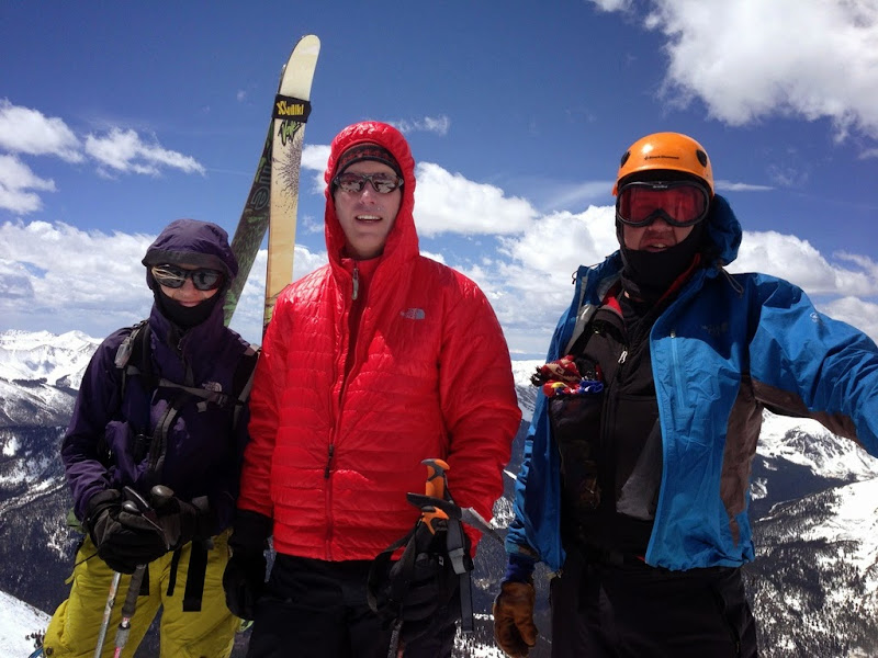 Our summit shot - although May, it was cold and windy  Skiing off the summit under the summit ridge  Skiing below the ridge  Off the saddle we go - Michael leads the way We skied down the ridge for about hundred feet and found this nice basin with some steeper lines! At first, we couldn't tell if any of them would go because of the cliffs, but after some scouting, we took the furthest one to our right and it looked pretty good. Although somewhat thin/rocky in spots, it had wind-blown powder in the upper half and a bit heavier, more saturated snow near the bottom.  Skiing our line  Michael skiing  Ruth and Eric on the steeper section near the top 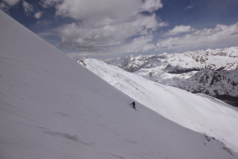 Brian on the steeper section  Natalie skiing  Enjoying the snow  Nearing the bottom of the run  Our tracks  An overview of the line But then it was a payback time - we had to get down to the North Cottonwood Creek trail, but since I didn't have any relevant waypoints in my GPS, I couldn't be much of a help with navigation. So we bushwhacked along the creek for a while until we finally (!) - something like 3 hours later after skiing off the summit - merged with the summer standard trail, which also required further bushwhacking on skis. All in, it turned out to be a long deproach, with lots of good laughs. We got to our shuttle car around 5pm, for an 11.5 hour day. Even with the bushwhack out, it was a fun day - and we were glad we got to ski such a fun line! Thanks, Matt.  Sidehilling next to a creek - Michael  A "good" trail with no tracks  |
| Comments or Questions | ||||||
|---|---|---|---|---|---|---|
|
Caution: The information contained in this report may not be accurate and should not be the only resource used in preparation for your climb. Failure to have the necessary experience, physical conditioning, supplies or equipment can result in injury or death. 14ers.com and the author(s) of this report provide no warranties, either express or implied, that the information provided is accurate or reliable. By using the information provided, you agree to indemnify and hold harmless 14ers.com and the report author(s) with respect to any claims and demands against them, including any attorney fees and expenses. Please read the 14ers.com Safety and Disclaimer pages for more information.


