Download Agreement, Release, and Acknowledgement of Risk:
You (the person requesting this file download) fully understand mountain climbing ("Activity") involves risks and dangers of serious bodily injury, including permanent disability, paralysis, and death ("Risks") and you fully accept and assume all such risks and all responsibility for losses, costs, and damages you incur as a result of your participation in this Activity.
You acknowledge that information in the file you have chosen to download may not be accurate and may contain errors. You agree to assume all risks when using this information and agree to release and discharge 14ers.com, 14ers Inc. and the author(s) of such information (collectively, the "Released Parties").
You hereby discharge the Released Parties from all damages, actions, claims and liabilities of any nature, specifically including, but not limited to, damages, actions, claims and liabilities arising from or related to the negligence of the Released Parties. You further agree to indemnify, hold harmless and defend 14ers.com, 14ers Inc. and each of the other Released Parties from and against any loss, damage, liability and expense, including costs and attorney fees, incurred by 14ers.com, 14ers Inc. or any of the other Released Parties as a result of you using information provided on the 14ers.com or 14ers Inc. websites.
You have read this agreement, fully understand its terms and intend it to be a complete and unconditional release of all liability to the greatest extent allowed by law and agree that if any portion of this agreement is held to be invalid the balance, notwithstanding, shall continue in full force and effect.
By clicking "OK" you agree to these terms. If you DO NOT agree, click "Cancel"...
Four Mile Creek Trail
Round trip distance: 15 miles
Start Time: 5:55am
West Buffalo Summit: 9:15 & 11:25
East Buffal Summit: 10:30
Pt. 12917 Summit: 11:45
Finish: 2:25pm
Weather: Clear skies throughout morning. Clouds forming over Sawatch by 10:30. Raining over Sawatch by 11am. Distant rumbles approaching noon. No rain on us during entire hike.
The Buffalo Peaks was a "must do" for us because we can see it clearly from our bedroom window:
We parked at the start of the jeep road at the end of CR375, 1.5 miles before the TH. However, the jeep road is in very good shape with no ruts and not much in the way of large rocks.
There are nice views of Mt. Princeton and Midland Hill from the TH.
The Four Mile Creek trail is a mellow hike along the creek for much of the way, with lots of wildflowers. It gains about 1,400 feet during the 3 miles from the TH to the Four Mile pass. There is a re-route that we missed on the way out. We hiked over a beaver pond (as had others, we could tell) and found a trail on the other side that was briefly blocked off with logs. We continued and came across another area where the trail was covered in logs and debris after which we saw a new and very good trail that emerged from the east. (NOTE: the attached GPS log file only has the return route, following the correct trail, so that no one else makes our mistake.)
At the top of the pass there is a sign post, with no sign. We turned right (east) here and followed a clear path through the willows, made our way through the open woods to tree line then up the slope of Pt. 12917. We thought we heard voices in the woods, but saw no one.
Deciding to save the 12er for the return trip we made our way around the south side of the mountain to gain the saddle to West Buffalo. This was a mistake. Nothing dramatic, but we had to cross a large talus field and downclimb a bit to get the saddle. Going over the top of the 12er would be my suggestion for anyone doing this route.
The climb to West Buffalo was straight-forward, with a faint path appearing now and then.
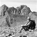
The summit, itself, is typical of the Tenmile Range in that it is large and flat. The views of the Sawatch Range and Arkansas Valley from the summit are awesome.
The ridge between West and East Buffalo is the real prize of this climb. The rock formations and cliffs are very dramatic. About 1/3 way across the ridge we saw a person on top of West Buffalo, behind us. He was there for quite awhile but never made the trek to East B.
And the wildflowers are spectacular right now.
On the return trip, we followed the correct trail re-route and found where we had gone wrong. The re-route crosses the creek about 3/4 of a mile from the TH. We had passed this assuming it was the turn onto the Salt Creek Trail. The old trail continues straight and it was only blocked off by throwing a bunch of rocks on the trail. This being Colorado, we just assumed it was a rocky trail. Before and after this turn the trail is very good and clear of rocks. On the way up, keep an eye out and cross the creek even though there appears to be a trail going straight. When you come to a sign, before the 2nd creek crossing cross the creek and continue on the Four Mile Creek Trail to the pass.
My GPS Tracks on Google Maps (made from a .GPX file upload):
Nice......I was just there on Sunday, hiking the peaks from the northeast side (off CR 431/Lynch Creek). Such a great hike, didn't see anyone. And I agree, the ridge between the peaks is gorgeous !
I too have only done the route from the east side and would love to explore the high country west of the Buffalo Peaks. You said you stopped 1.5 miles short of the TH, approximately what elevation is the TH itself?
Caution: The information contained in this report may not be accurate and should not be the only resource used in preparation for your climb. Failure to have the necessary experience, physical conditioning, supplies or equipment can result in injury or death. 14ers.com and the author(s) of this report provide no warranties, either express or implied, that the information provided is accurate or reliable. By using the information provided, you agree to indemnify and hold harmless 14ers.com and the report author(s) with respect to any claims and demands against them, including any attorney fees and expenses. Please read the 14ers.com Safety and Disclaimer pages for more information.
Please respect private property: 14ers.com supports the rights of private landowners to determine how and by whom their land will be used. In Colorado, it is your responsibility to determine if land is private and to obtain the appropriate permission before entering the property.


")
")
")
")
")
")
")
")
")
")