Download Agreement, Release, and Acknowledgement of Risk:
You (the person requesting this file download) fully understand mountain climbing ("Activity") involves risks and dangers of serious bodily injury, including permanent disability, paralysis, and death ("Risks") and you fully accept and assume all such risks and all responsibility for losses, costs, and damages you incur as a result of your participation in this Activity.
You acknowledge that information in the file you have chosen to download may not be accurate and may contain errors. You agree to assume all risks when using this information and agree to release and discharge 14ers.com, 14ers Inc. and the author(s) of such information (collectively, the "Released Parties").
You hereby discharge the Released Parties from all damages, actions, claims and liabilities of any nature, specifically including, but not limited to, damages, actions, claims and liabilities arising from or related to the negligence of the Released Parties. You further agree to indemnify, hold harmless and defend 14ers.com, 14ers Inc. and each of the other Released Parties from and against any loss, damage, liability and expense, including costs and attorney fees, incurred by 14ers.com, 14ers Inc. or any of the other Released Parties as a result of you using information provided on the 14ers.com or 14ers Inc. websites.
You have read this agreement, fully understand its terms and intend it to be a complete and unconditional release of all liability to the greatest extent allowed by law and agree that if any portion of this agreement is held to be invalid the balance, notwithstanding, shall continue in full force and effect.
By clicking "OK" you agree to these terms. If you DO NOT agree, click "Cancel"...
Castle + Conundrum via Brush Creek (Crested Butte)
I left the Brush Creek 2WD trailhead at 4:30 AM. My car thermometer read 37�. It was still dark, but I had to make the additional 7 mile trip to Cumberland Basin on Pearl Pass Road by foot. I had tried to scout out the road the day before to see how much further up it I could go, but less than a quarter mile in, my Subi started making a really really loud squealing sound. Don't really know much about cars, but I think it might have been the axle. Unwilling to risk an expensive repair bill and/or tow, compounded by the wet weather we'd been having recently, I took it as a sign to turn around and not test my luck. As Kenny Rogers said, "You've got to know when to hold 'em, Know when to fold 'em, Know when to walk away, And know when to run." Luckily, it stopped when I got back on solid dirt road. Anyways. If I were to do this again, I'd try to find a way to drive in. Walking the dirt road wasn't exactly the most enjoyable.
When you get there, you'll find that the trailhead is not very well marked, and you'll soon learn it's not very well maintained either. I hiked all the way up to the switchback on Pearl Pass Road and looked down to see the wilderness boundary sign. The trail proper starts a couple hundred yards or so in a patch of trees, but I missed it. I started hiking the trail, but quickly lost it.
Wilderness boundary sign. You can catch the overgrown trail here
From here, it takes some careful spotting to stay on the trail. It's actually pretty well defined if you look carefully. I was way up Cumberland Basin before I rejoined it. Until then, I was doing some serious bushwhacking in pretty sensitive riparian areas. The basin was still shaded and surprisingly frigid, and I was cold and wet from the frosty willows. When the sun finally hit the basin around 8:00, I took some time to dry off and warm up. Unfortunately, I wasn't out of the sea of willows yet, and I would continue to be cold and wet for a while yet. For these reasons, I strongly recommend finding and staying on the trail. You'll still have to navigate the willows in some spots, but it's much much much better than the alternative. Stay on the east side of the basin well away from the creek if you're ever in doubt. Until you get above the lakes, the trail mostly stays out of the willows.
Looking back. Seemingly endless frost-covered willows left me pretty sapped, even when the sun came up.
Once you get above the lakes and treeline, the willows become unavoidable, but manageable. You get your first glimpses of Castle proper here. All you see are it's turrets before that. Continue past the willows until you get to the field of wildflowers, where you can plan your route.
First sight of Castle and Pt. 13,820
Castle's namesake turrets
Fireweed! Probably my favorite wildflower
These next couple pictures were taken on the way down, but they better illustrate my descriptions here. Gerry Roach's topo shows the route up going the left (west) side of Pt. 13,820 (dubbing it "Middle Castle" from here on) and traversing up and over it, but the slopes right (east) of it seemed just as viable. I hiked up the right side of the talus field just below "Middle Castle" to just below the couloir to the right (east) of it. The talus field on the right side of the amphitheater (proper term?) is a gentler slope, and would be my route should I ever return. I was surprised to see so much snow still on the slopes, and I was sorely wishing I had brought my ice tools and crampons. It would have certainly helped in the notch couloir, but there was an even steeper couloir going up the south face that would have bypassed much of the scree I would be ascending on the upper slopes and would spit me up higher on the ridge. Oh well.
Notch and Castle Couloirs (my names). The talus field to the right is a gentler slope. The lowest patch of snow and cliff ban
View from the descent. My ascent route brought me from the left, just past the patch of grass
My route up the grass field took me to the base of Notch Couloir. Without crampons, I took one of the other gullies relatively free of snow. Was still pretty muddy though, and I kicked down a lot of loose rock here. This would continue until I gained the ridge. A few third class moves here, but nothing crazy
On the ascent. View of Notch Couloir. Without axe or crampons, I ascended via one of the gullies
A look down my chosen gully
Scree nightmare to the ridge
Middle Castle from the ridge
Conundrum from the ridge
Looking back at Cumberland Basin
From here, just follow the ridge up to Castle. There'll be one false summit at the top of Castle Couloir, so don't worry about the trail not seeming to go straight up.
My face when false summit
Top of Castle Couloir
Soon enough, you'll reach the summit!
The rest of the Elks
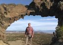
And me
Looking back toward Teocalli and Crested Butte
Looking west
More of the Elks
Montezuma Basin. Looks intense
More Montezuma
Saw quite a few other people hiking up from Montezuma Basin. Apparently a lot of other people had already summitted from that side. No big deal, I had a long approach. But you could see their cars! Admittedly, I was a bit disgruntled. (Start rant) One-way to Conundrum, it would be about 10 miles and 6,000' elevation gain. I had two rationalizations for the route I took: (1) that the extra mileage from Brush Creek would just be more training and (2) I didn't want to drive to Aspen (and use gas). I don't mind the extra effort, but it was the disparate difference in effort from a large group that bothered me most (End rant and elitism). Shortly after I summitted, another Crested Butte resident summitted, using a dirt bike to get to the trailhead at Cumberland Basin. The other CB resident (Elijah) and I hiked to Conundrum and made the descent back to the trailhead. Seemed like a cool dude and had the same stoke (and conditioning) level for peakbagging I do. I have 2 more Elks to go (Pyramid and Capitol), so maybe I won't have to do them solo.
Me on Conundrum looking back at Castle
Cumberland Basin from the trailhead
Back at the trailhead, I hitched a ride back with Elijah, grabbed a few well-earned beers and made tentative plans for our next 14ers
Thumbnails for uploaded photos (click to open slideshow):
As far as I could tell, there were only three cars that drove to the end of the road, to the mine. Most of us, hiked round-trip at least 10 miles. Seems silly to drive to 12,800ish in order to hike to 14,000...But walking up the road did suck.
Hey, Meteor and I met you at the top of Castle as you summited, and I took a couple pictures of you with your phone... Was definitely a cool surprise to see someone reach the top coming from the other side of the mountain . HikingMan is right, the long trudge down the road in the sun to below the Pearl Pass turnoff wasn't that great. I'm sure the scenery on your route was much nicer, even if it was longer.
...wasn't aimed at anyone in particular I guess. If the road exists and is deemed legal to use, is it wrong for people to use it? I often forget how my cynical sense of humor isn't shared by everyone else. I don't feel any animosity towards anyone really.
If anything, I'm a bit miffed that the road even exists and is open for use that far into what should be wilderness area. Just my 2c I guess.
Anyway, thanks for the pictures Scanner. They turned out great! You and Meteor were traversing back to Castle when I gained the ridge. If you look closey at the picture of Conundrum from the ridge, you and Meteor can be seen as two dark lumps
Our party of Santa Feans is headed up to Cumberland Basin and up to Castle this September 2017, and this report plus the 14 minute UTube video of 4WD from Pearl Pass to CB, gave me everything I need to lead this trip without doubt. I was just wondering about this Notch Couloir, and so your pix are invaluable compared to others. No doubt this trail is getting more use now, which will wear the willows back slowly but surely. Same problem on the lesser used South side of La Plata trail. We'll add a few pix in our own report, then there will be at least 3, including the Castleabra one here.
Caution: The information contained in this report may not be accurate and should not be the only resource used in preparation for your climb. Failure to have the necessary experience, physical conditioning, supplies or equipment can result in injury or death. 14ers.com and the author(s) of this report provide no warranties, either express or implied, that the information provided is accurate or reliable. By using the information provided, you agree to indemnify and hold harmless 14ers.com and the report author(s) with respect to any claims and demands against them, including any attorney fees and expenses. Please read the 14ers.com Safety and Disclaimer pages for more information.
Please respect private property: 14ers.com supports the rights of private landowners to determine how and by whom their land will be used. In Colorado, it is your responsibility to determine if land is private and to obtain the appropriate permission before entering the property.


. The talus field to the right is a gentler slope. The lowest patch of snow and cliff ban")


 Wilderness boundary sign. You can catch the overgrown trail here")
 Looking back. Seemingly endless frost-covered willows left me pretty sapped, even when the sun came up.")
 First sight of Castle and Pt. 13,820")
 Fireweed! Probably my favorite wildflower")
 On the ascent. View of Notch Couloir. Without axe or crampons, I ascended via one of the gullies")
 A look down my chosen gully")
 Scree nightmare to the ridge")
 Middle Castle from the ridge")
 Conundrum from the ridge")
 Looking back at Cumberland Basin")
 My face when false summit")
 The rest of the Elks")
 And me")
 Looking back toward Teocalli and Crested Butte")
 Looking west")
 More of the Elks")
 Montezuma Basin. Looks intense")
 More Montezuma")
 Me on Conundrum looking back at Castle")
 Top of Castle Couloir")
 View from the descent. My ascent route brought me from the left, just past the patch of grass")
 Notch and Castle Couloirs (my names). The talus field to the right is a gentler slope. The lowest patch of snow and cliff ban")
 Cumberland Basin from the trailhead")
 Castle's namesake turrets")