Download Agreement, Release, and Acknowledgement of Risk:
You (the person requesting this file download) fully understand mountain climbing ("Activity") involves risks and dangers of serious bodily injury, including permanent disability, paralysis, and death ("Risks") and you fully accept and assume all such risks and all responsibility for losses, costs, and damages you incur as a result of your participation in this Activity.
You acknowledge that information in the file you have chosen to download may not be accurate and may contain errors. You agree to assume all risks when using this information and agree to release and discharge 14ers.com, 14ers Inc. and the author(s) of such information (collectively, the "Released Parties").
You hereby discharge the Released Parties from all damages, actions, claims and liabilities of any nature, specifically including, but not limited to, damages, actions, claims and liabilities arising from or related to the negligence of the Released Parties. You further agree to indemnify, hold harmless and defend 14ers.com, 14ers Inc. and each of the other Released Parties from and against any loss, damage, liability and expense, including costs and attorney fees, incurred by 14ers.com, 14ers Inc. or any of the other Released Parties as a result of you using information provided on the 14ers.com or 14ers Inc. websites.
You have read this agreement, fully understand its terms and intend it to be a complete and unconditional release of all liability to the greatest extent allowed by law and agree that if any portion of this agreement is held to be invalid the balance, notwithstanding, shall continue in full force and effect.
By clicking "OK" you agree to these terms. If you DO NOT agree, click "Cancel"...
Total stats over 2 days:
Distance: ~22 miles
Vertical: ~6,400 ft
Time: ~ 21 hours
Creek crossings: 6
Day 1 - Phoenix Pk and UN 13,402
Approach: Ca�on Diablo from Eddiesville TH
Distance: ~ 13 miles
Vertical: ~4,500 ft
Time: ~12 hours
While researching the routes for the Phoenix group, the Eddiesville TH really stood out at me. The ford of Cochetopa creek that may or may not be practical in a high snow year? Check. Finding a trail up the canyon that may or may not exist on most maps? Check. Two bonus 13ers that are otherwise very hard to reach? Check. Not to mention to actually see the place called "Ca�on Diablo". The only beta I could scout was a TR on a monster day from Furthermore (from the Creede side) and a Facebook photo deck from Kmensh with the title "Too long for one day". If that doesn't spell the challenge, I don't know what else does.
Initially, I was hoping to tag the group from the nearby Stewart group as a multi-day backpack. When that didn't go exactly as planned, Phoenix remained high on my list with the idea to approach it sooner than later. With the amount of rain the mountains have received recently, I was reluctant to touch anything with loose rock, so Phoenix quickly rose to the top of my list. I sent out a few feelers and the responses I got were: "I am saving it until later", "weather looks like crap" and "I am doing something else this weekend" and this was before I even mentioned Eddiesville TH, Ca�on Diablo and an overnight backpack. A wise person once wrote: "never put until tomorrow what you can do today". I was itching to get out even despite the recently tweaked foot, so I packed up and left Denver after work on Friday. It is possible to do this trio of peaks in a long one-day push, but too many factors have to fall into place: flawless route finding, perfect weather and great conditioning. Since I wasn't confident in any of the three, I decided to do it as a 2-day backpack to increase my odds of success - in case the weather doesn't cooperate on Day 1, I will still have Day 2 to play with. And if by any chance I am done with all 3 peaks on day 1 and come back, I'd consider carrying the overnight pack as training weight. It's nice to have flexibility.
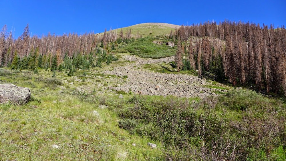
The road to Stewart creek appeared to have been recently improved (vs a month ago) and I had no trouble reaching the Eddiesville TH. Since my foot was giving me some minor trouble the week before, I decided to take an extra pair of shoes - Asics - in addition to my trusty Vasques. The alarm went off at 4.30am, but I kept hitting the snooze button. Mercifully, a couple started slamming the doors on a car parked right next to me - they were getting ready for San Luis - thus saving my day. I finally started moving around 5.00am or so and set out around 6.30am on Colorado Trail (aka Skyline trail), not sure what to expect. Not before long, I ran into a huge heard of cows - in fact, I had to politely ask them to move off the trail to let me pass. There was cow's and horse's poo everywhere, and the trail was wet. That sealed the decision for me to not come back this trail in the dark - the glowing cow's eyes in the dark are very spooky and I prefer to see what I am stepping into (or may be not - depends on your perspective). A couple of cattle guards later and the amount of poo on the trail has lessened. My foot was giving me minor trouble, but wasn't too bothersome. Pleased with the progress I was making so far I got even with Ca�on Diablo about 4 miles in and realized that it's about time to look for a river crossing.
Not so scary Cochetopa river crossing
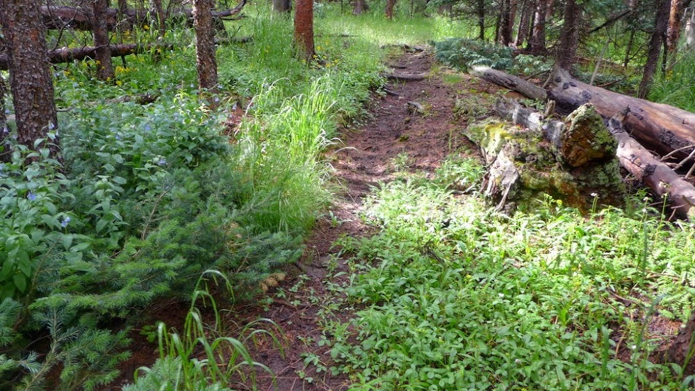
I may have overshot a spot Roach describes in his book, but the spot I found worked well enough for me. I was sad to leave the comfy confines of the Colorado Trail, but the adventure awaited. I changed into my "water shoes" - a pair of Crocs - and made the river crossing with no issues. I found a weakness in the canyon walls and was quickly on the other side. Welcome to Ca�on Diablo. Now to find the trail that may or may not exist. I took off in the general direction I needed to go and about 0.2 miles later ran into something that looked like a possible 13er trail (although it wasn't coming from the side I was expecting). I followed it to the Diablo creek crossing - well, it's definitely a trail.
Welcome to Ca�on Diablo
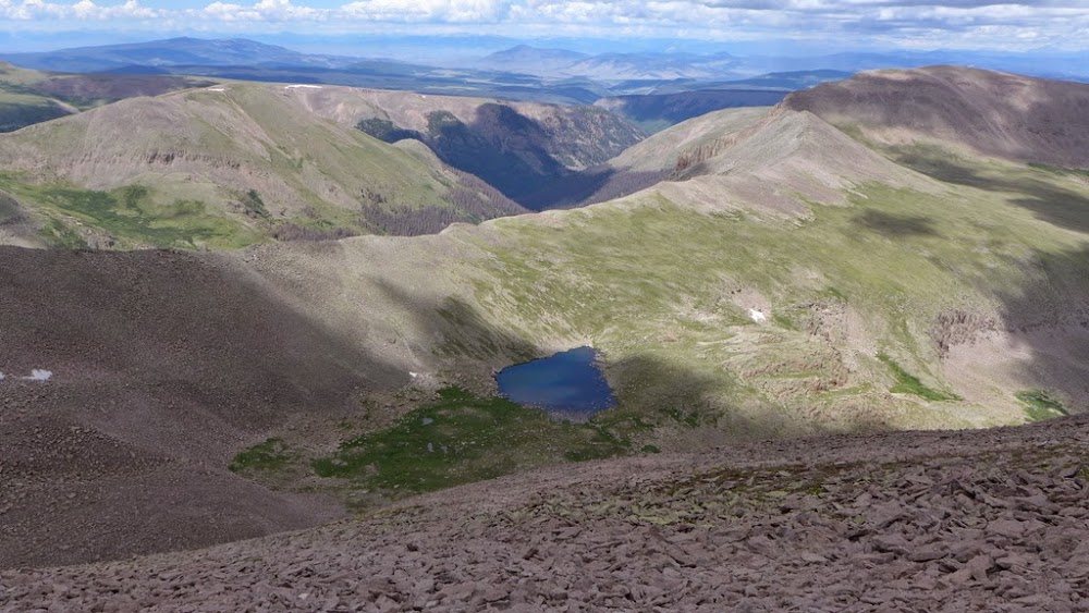
First look into the basin - on the left is Pt 13,402
Very pleased with the developments, I followed the "trail" into the canyon. Technically, it may be described as a trail, but it is very faint and a lot of deadfall makes it disappear at times (it may give a NoName trail a run for its money). Still, it is better than nothing. Plodding right along, at around 10.30am I reached a relatively flat spot near 11.4k and decided to set camp there. I wanted to set up tent before the rain starts and eat lunch while evaluating my options. While the trail and the creek cooperated, the weather (3rd and major variable) looked as threatening as ever - and it's not even noon. Frustrated, I took time to set up tent and eat lunch while watching the cloud development. I "could" stay in my tent the rest of the day - and it sounded really appealing - or I may try to go in the direction of Phoenix Peak. My initial plan for that day was to set up camp and attempt UN 13,015 to get a lay of the land and deal with Phoenix Pk and UN 13,402 the following day, but the forecast before I left for Saturday looked significantly better than for Sunday, so I didn't want to delay the peakbagging effort until the 2nd day. If the Day 1 looks so iffy with the "good" weather forecast, I could expect a full-blown monsoon and rain at 9am on Day 2.
I changed into much comfier Asics with their thick cushion and rubber soles and set off towards Phoenix. The approach seems to go and go and go. I kept checking my GPS and the sky trying to gauge my progress. The clouds seemed to be rolling over the hills slowly with some blue patches and it finally started to look like there might be an opportunity. After about a mile I ate a GU to speed up my progress (otherwise why waste a GU?) and kept fingers crossed for the weather to hold.
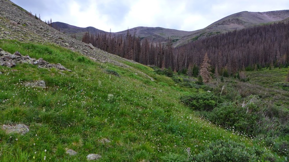
Heading further into the basin
Weather seems to be holding up
Organ and Pt 13,015
Cliffy side of 13,402
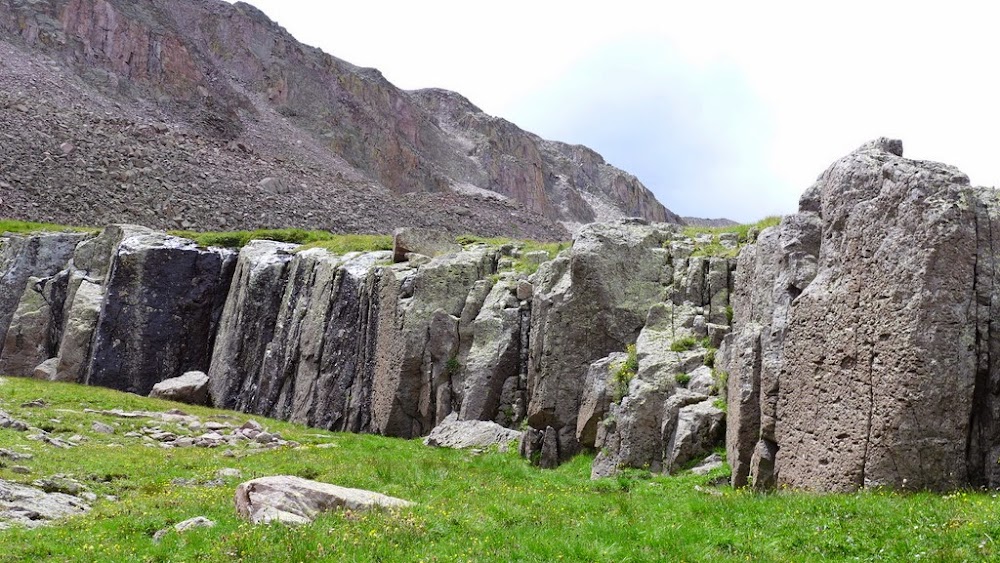
Some unwelcome talus hopping to reach Continental Divide
I was excited to reach the Continental Divide near 13.1k as I was expecting to finally see Phoenix from there. And here it was.
Phoenix rising
the ridge to Pt 13,628
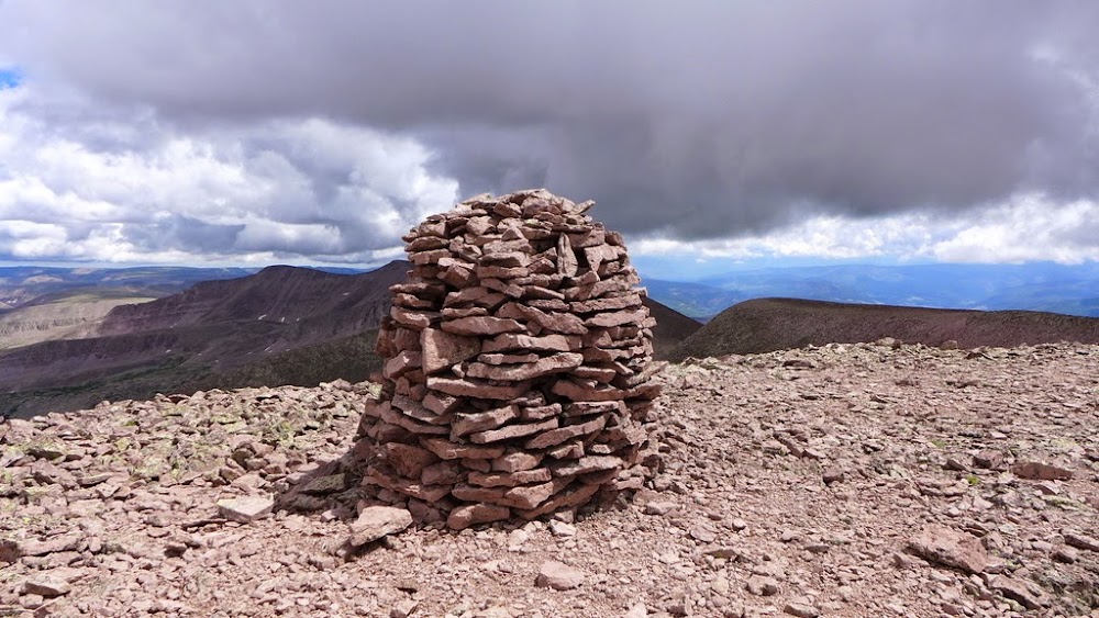
Who would have guessed that such an "easy" peak might be so hard to reach? I recall looking at it from Stewart and it looked impossibly far. Now it's the turn for Stewart, Baldy Alto, and San Luis to look impossibly far. I went over UN 13,628 and started on the ridge up Phoenix. The clouds were starting to look threatening - why they "always" do that when I am 300 feet from the summit? Thankfully, the weather held long enough for me to reach the summit, sign the soaked through register and eat some food.
Summit cairn
San Luis, Baldy Alto, Organ and Stewart miles away
Not to overstay my welcome, I left about 30 minutes later with the goal being UN 13,402. I contemplated going over UN 13,628 again, but decided to save some energy for later and I knew my left foot doesn't like talus hopping. I descended from the saddle to the unnamed lake (might be unpleasant, but not terrible), and it was a grassy stroll from there.
Descent to the unnamed lake
13,402 ahead
the lake
Except it is a very long grassy stroll. The weather over Phoenix and particularly La Garita was getting worse, while UN 13,402 still had sunny skies above it. Nice! I got to the summit of UN 13,402 just before 5pm - it took me 2.5 hours, I must be tired or something.
Looking back at Phoenix and connecting ridge from Pt 13,402
The summit register was really cool though. It went back to 1999 and the names read as "who is who" in 13er peakbagging. The foot was loudly complaining by then and UN 13,015 was out of question. Now I only had to solve 2 puzzles - a descent off UN 13,402 and an acceptable route up 13,015 ft for tomorrow (assuming the foot cooperates). The west side of UN 13,402 is loose and most of the gullies on that side cliff out. I decided to keep going north from the summit as I spied a grassy shoulder on the approach. It turned out to be a good choice - after some minor talus hopping, I was on a much more forgiving terrain - steep grass, but it was grass, not rocks. As an added bonus, I had a great vantage point of UN 13,015 and could plot an ascent line for tomorrow. Tired, but pleased with the developments, I arrived at my camp by 6.30pm ready for rest and recuperation.
Finding the grassy shoulder on north side of UN 13,402
Reasonable descent line off UN 13,402
UN 13,015 with multiple ascent options - I went up the gully in the middle and then veered off towards the ridge on the right/north side
Cliffy side of UN 13,402 as seen from the camp
Day 2 - UN 13,015
Distance: ~9 miles
Vertical: 1,900 ft
Time: ~9 hours (includes lunch breaks, etc)
As I was waking up I had only one request "please don't let it be raining". And it wasn't - it was as a clear blue bird day as they come. The thought of oatmeal and zero approach finally lured me out of my tent around 7 am or so. I was debating between leaving the camp or packing up and taking it down to the start of the gully. It wouldn't be a debate if I camped 0.2 miles lower. Eventually, I packed up the camp and carried the big pack to the river crossing #3. Securing a pack and keeping fingers crossed for no disturbance from the animals, I took off around 8am.
The ascent gully from the creek crossing
Looking down
The weather was perfect and the going was easy. The foot was not hurting. The gully was steep, but not too difficult. I kept seeing segments of the trail. As I got about 1,000 ft higher, I saw the clouds in the valley - an inversion effect. From my vantage point I could see Phoenix Peak, about 2 miles away.
Phoenix rises again
The inversion effect in the valley below
Blink and you missed it - 20 minutes later
Another 10 minutes later
Another look at Phoenix and Continental Divide
UN 13,402 and the green shoulder descent line the day before
My pack and the summit cairn and register
San Luis, Organ and Cochetopa drainage from Pt 13,015
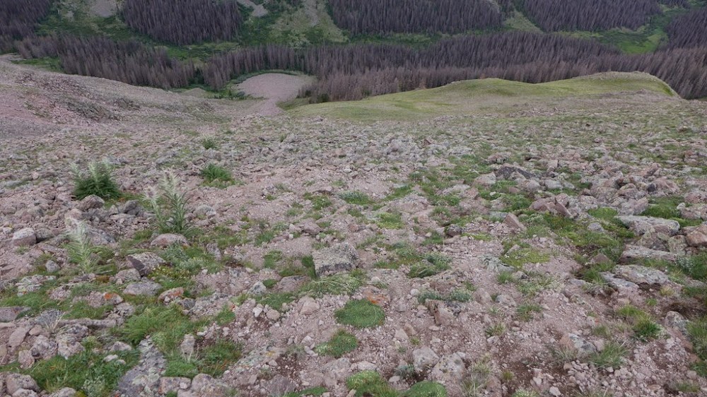
After taking many photos I reached the summit just before 10am. Another cool (and wet register). After eating some food and admiring the nearby peaks, it was time to head back. Got to the "big" pack without incident for a 3.5 hours RT with 40 minutes on the summit. Dried off the tent, took a long break to eat lunch by the creekside in a field of wildflowers and started down around 1pm.
The trail was actually harder to see (because of the deadfall) on the way back and I made a few detours, but eventually reached the Colorado Trail 1.5 hours later, including 2 creek crossings. From there it should be a breeze back to the car, or so I thought. There were no cows on the trail, the poo was dry and the sky was blue. Alas, about 1.5 miles away from the car the foot decided to start giving me a major trouble. I changed from one pair of shoes to another to no relief. Eventually, I limped to the car, arriving just before 5pm. Please, somebody lock me up and don't let me hike this weekend...
We are not cows. Cows are not we.
My GPS Tracks on Google Maps (made from a .GPX file upload):
Bill's mapping tool. But in this case (as in case with Organ Stew loop) it seemed to somewhat underestimate the totals. Glad I brought the overnight pack as the total stats seem a bit daunting for mere mortals to pull it off as a day trip, considering the iffy weather.
p.s. Glad it would help you with planning! That's why I posted this.
Kay - glad you enjoyed the read. I was thrilled to find the trail into the basin - without the trail the adventure may have indeed turned into diabolical bushwhacking
Abe - the Colorado trail portion of the loop is definitely runnable (assuming you can duck the cow and horse poo fast enough or just stop caring ). The first time I did San Louis I am sorry to say I didn't take the time to appreciate the area. It is really unique. Gentle Giants - well put. Hope you are doing well.
Derek - appreciate the comment. Not that many entries in the registers since you signed them. Thanks again for the inspiration and for the TR - it was very helpful. The gully you descended off 13,402 looked pretty loose! It was pretty quiet in the basin once I left the CT.
Doug - I've really enjoyed seeing the cloud inversion a few times I had a chance, always a treat. Good point on beetle damage, indeed it is a major issue in the basin. At least the grass and wildflowers provide a visual relief in the summertime.
Sean - picture taking is hard work and really slows me down. At least that's what I am telling myself Thank you!
Caution: The information contained in this report may not be accurate and should not be the only resource used in preparation for your climb. Failure to have the necessary experience, physical conditioning, supplies or equipment can result in injury or death. 14ers.com and the author(s) of this report provide no warranties, either express or implied, that the information provided is accurate or reliable. By using the information provided, you agree to indemnify and hold harmless 14ers.com and the report author(s) with respect to any claims and demands against them, including any attorney fees and expenses. Please read the 14ers.com Safety and Disclaimer pages for more information.
Please respect private property: 14ers.com supports the rights of private landowners to determine how and by whom their land will be used. In Colorado, it is your responsibility to determine if land is private and to obtain the appropriate permission before entering the property.