| Peak(s): |
Crestone Needle - 14,196 feet Uncompahgre Peak - 14,318 feet |
| Date Posted: | 08/09/2014 |
| Date Climbed: | 08/02/2014 |
| Author: | Krullin_14ers |
| Peak(s): |
Crestone Needle - 14,196 feet Uncompahgre Peak - 14,318 feet |
| Date Posted: | 08/09/2014 |
| Date Climbed: | 08/02/2014 |
| Author: | Krullin_14ers |
| Still waiting for Obamacare. Lets take a road trip. |
|---|
|
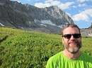
Hello again my children. Guess who's back with another report. Man did I have a hard time consolidating it down to ONLY 40 photos. Sometimes I can get a little out of control with my picture taking. Anyway, here we are, all fine tuned. A good read indeed. It was a crisp friday afternoon when we departed Boulder. The wind was at a slight SE direction, and the ant hill outside my house was thriving. We we're all packed up to head down to lake city with one thing on our mind - Uncompahgre, but really two for me (a mcflurry in Gunnison was really calling my name). LEaving boulder, we had the ever so gracious presence of traffic that I can never seem to avoid. For some reason I always manage to add on an additional hour by leaving at the best times. We departed with literally nothing prepared, no food, no plans and not even full tummy. I was quite worried for what the weekend had in store for us. We stopped in safeway in idaho springs to collect a few essentials for the weekend. I bought a dozen eggs and a small "non stick" pan to cook the little guys on. It took about 5 hours to get to lake city via i70 > leadville > salida >gunnison. We arrived to lake city around midnight even though we had hoped to arrive a few hours prior. I was familiar with the road as I had done wetterhorn a few weeks back. When the road to uncompahgre splits off, you are pretty much committed to going all the way (with only a few spots to pull off). The road crosses a stream 2x and that is honestly the worst part (and the most fun javascript:emoticon(' Finally we made it to the trailhead with little time to spare. Inflated the air mattress (LOL) and got to snoozin. I was sure to park the car on a healthy slope so there would be no awkward sleeping angles. The reason for hiking Uncompahgre was for the Colorado54 and Second Mile Water, in which my friend raised a few hundred dollars to help bring clean water to families in Nicaragua. yahoo! Shouts out to that effort! ('  ^^AHHH another morning in the beautiful CO wilderness. Waking up and enjoying some tea b4 having to exercise. It was a late morning, as we have fallen into a nasty habit of hitting the snooze button. I think the alarm was set for 545, only to wake up at 715...phew guess were getting old! (' After nearly 15 hours of the eggs not being refrigerated, i was beginning to wonder if they had gone bad, or possibly hatched. Thank god they hadn't hatched, I couldn't handle that many chic's in my life right now. Nearly 30 minutes of dilly dallying, we were off...off for clean water!!  ^^About a quarter mile in, enjoying the looks of some water and some uncompahgre.  ^^After a third of a mile, you begin to make some elevation gain and get to catch a glimpse of this fantastic water flow. Just look at those curves! OHH WEEE. If I was a trout i would do laps in this bad boy.  ^^sorry, one more water feature, cloudy because i caught this one on the way down. Notice how i added a little foreground/background. Thats a little photography class kicking in, glad to see a remember something. I just couldn't get enough of this stream...just wanted to grab a mini canoe and go for a ride.  ^^Providing a fantastic glimpse of the ever so powerful Uncompahgre. She really is a beaut. So robust and strong at the hips...had me thinking, was i going to summit? This is taken just outside treeline, so the majority of the hike is in view.  ^^Another view of the beast. Very gradual and beautiful at this point.  ^^How did this pic make it on here?? No comment.  ^^Here you reach some serious elevation gain, and are rewarded with quite a view. A couple loose rocks but nothing to get your panties in a bunch about. It is important to follow the cairns at this point because if you go off trail, you will simply be doing more work than you should be.  ^^GUESS WHO THAT IS IN THE BACKGROUND?? Hint: its not Santa!...its Wetterhorn! Oh do i love that mountain too. What a range, just want to take it home with me.   ^^Summit pics. IT was really an awesome summit, very large, similar to Longs. Wasn't too busy, almost saw more dogs than people! I don't know if you can see but in photo 10, there is a large "herd" of sheep below. A hundred of them there must have been. Pretty cool. When it was real quite we could hear them all the way down there. Get some sheep in ya life. - if you need one, I'm sure they are still down there, they seemed to be having a good time.  ^^After snapping some summit photos, and celebrating Second Mile Water, we came back down. Very mellow and relaxing descent, nothing real steep. I really liked Uncompahgre, it was a fantastic mellow hike. Honestly, for beginners, I would suggest this one over Bierstadt/greys/torreys. I know it is far away and requires 4x4, but its super relaxing and provides for some awesome views you won't find in the front range. You start at over 11k feet and only have to go 3.2 miles up. Do it!  ^^Back at the car, we debated what to do next, what 14er did we want to do sunday? Well we couldn't know until we hit the local Lake City coffee shop. A special shoutout to that lake city WIFI - keeping us in check. After some contemplation and realization that the eggs still had not hatched, we decided on the Crestone Needle! I drank a cup of joe, used the boys room, munched a muffin and fired up that sweet subaru engine >>> WESTCLIFFE BOUND WE WERE!  ^^The drive was nothing special until i snapped this pic just a few miles shy of westcliffe. Upon entering westcliffe, we stopped at the local mart to purchase smokes materials and some american flag stickers. This was no ordinary market - it was quite the experience. Naturally, upon entering the market, I headed to the deli area. What I spotted was out of this world. Red meat so fresh it looked like the cattle was slaughtered an hour ago. This meat was so squishy and bright, wow. The chef inside me was goin nuts. But, i kept my cool and only bought smores materials. PHEW THE RESISTANCE WAS ROUGH. After leaving the market, we headed to the colony trailhead, which is only about 10-15 minutes past Westcliffe. This road was a little more rough than the Uncompahgre one, strictly because the holes were larger and the change for forgiveness was slim. (in an outback that is!) Thanks to a previous report, I kept my eye out for one section in particular - I think its 2.3 miles in - stay left going up! The upper trailhead was packed so we parked a little ways down in an EPIC spot.  ^^Time to get grilling!  ^^Say hello to the infamous hammok - waterproof - for the time being (' We cooked up a lot of eggs in my new non stick pan which turned out to be completely sticky. But oh well - ill bring PAM next time. It was an early night, as we knew it was going to be a long day tomorrow. An attempt was made to sleep in the hammock, but it got so moist out at night, that the thing was literally soaked > anyone know why this happens - humidity? but back to the lovely subaru, always providing 100% satisfaction - avoiding moisture buildup. We ended up hitting that damn snooze button again for a good hour and a half. This is something I knew was a bad idea. We were in unfamiliar territory and we're doing more technical climbing. We ended up leaving at about 645 when I would have liked to be out at 545. I did Humbolt back in the day with my pops, think it was 2008, and you could still drive all the way up. Now you start much lower (9k feet) and have to do 4 additional miles that you wouldn't have had to do back in 08. There are a couple theories as to why the road closed. 1. land bought with fishing and hunting money - don't want ATVs tearing road up. 2. Erosion. Either way - you gonna have to deal with it.  ^^Upon reaching the REAL upper TH, you will begin to loop around the basin. There are a couple signs that direct you, that you cannot miss. Here we are snapping a lil reflection pic in a beautiful lazy river segment. Imagine the fishing to be had here! was about to push her in - not enough reflection for two!('  ^^In the basin beginning the loop around. THis section is pretty flat and quite gorgeous. Make sure to snap those pics.  ^^Once you reach this sign, the steepness begins. Side note: Notice in the background a herd of goats had taken over someones campsite. A whole crew of em had set up shop - I assume they helped pitch the tent and help lay out the prayer flags? Good thing their food was strung in the tree.  ^^Right after the sign, looking into the first real steep part. Lots of loose rock here so be mindful. You will want to follow this all the way to Broken Hand Pass (the notch in the middle of this picture)  ^^Too good a selfie to not include. Here i am, almost to the top of Broken hand pass, looking down at what we just came up. A couple tricky moves right after this, honestly some of the hardest moves of this hike occur right here.  ^^After a couple of those difficult moves, you encounter the final ascent to Broken Hand pass. Once you pop out, you want to head RIGHT. BUT WAIT. look at all the great plants! like damn this is some prime real estate to be a plant on! Oh man - shout out to all those Stomata's providing that high altitude nutrition!  ^^Right after popping out of Broken hand pass, and after taking a right, this is what you see. Something out of LOTR right? Man was the weather special. Felt something similar to that of Narnia. The mist made this hike special. Not knowing where we were going was quite fun.  ^^Another look into the promised land. One of the many rocks i would refer to as "eye candy" At this point you will enter a gully - called the east gully. You can notice it by the water running down the middle of it. There are cairns placed all the way up, follow them. Avoid the water so your shoes remain grippy. The rock is stable here and as long as you are careful, you will have no problems.  ^^After a few hundred feet you will encounter this. Its called a Dihedral. For those of you that don't know what that is, here ya go. Definition: The dihedral angle of two planes can be seen by looking at the planes "edge on", i.e., along their line of intersection. The dihedral angle varphi_{AB} between two planes denoted A and B is the angle between their two normal unit vectors mathbf{n}_{A} and mathbf{n}_{B}: Since that definition is completely useless, allow me to explain. When you encounter this picture, you will need to cross over the crack and go into the west gully. The rock is stable so make good foot plants and you will be ok. Then climb into the west gully - it is very similar to the east gully.  ^^When i encountered this ice, i initially thought i was hallucinating. Was i at sonic? Had i just purchased a watermelon slush? THis stuff was perfect sonic ice, at least i now know where it comes from. ('  ^^Holy tamely look at this steepness! Intense, this is nearing the top of the west gully. It looks worse than it was. Again, rock is nice and stable allowing you to make nice foot plants. But really, soak in that angle, still pumped on it. From where this pic was taken, there is only a hundred feet left before the summit. Stay focused and don't look down, and you will make it to the top! Just imagine a watermelon slush at the top with some of that fresh sonic ice, even fresher than that westcliffe red meat!  ^^Nearly at the top. Cant get over these clouds, it was unreal. Just wanted to spread my wings and fly.  ^^the ultimate summit pic. Ok Ok, ill admit, I ran this one thru microsoft paint and touched it up a bit ('  ^^More summit. More mother nature. More problems.  ^^The hike up this was incredible, i think it is my new favorite (up there with pyramid). I can't explain fully how cool it was. The steepness, intensity, fog, and lack of knowledge of the area really made this a great experience.  ^^GUESS THE PEAK? Ill give you a hint, its Humboldt! Conquered that sucker back in 08.  ^^Dont share this report with anyone.  ^^Ah, looking back up at the Needle after a very satisfying hike. Absolutely breath taking.  ^^One of the many great pieces of vegetation down in the basin. Don't really know how to describe this specific one. Could it be a new sativa strain - thought i spotted a couple nuts in there? LOL  ^^We finished the 12 miles RT in about 9 hours. We jogged a good portion of the road they closed cuz we wanted to get back to the car real bad. Hunger was setting in, and i needed some of those left over marshmallows. Once back in the parking lot, we were faced with another tough decision. Where do we go next? The sand dunes seemed like a great option as we both had never been. In the parking lot, we met a local, he was quite the chatter, so naturally i wanted to get some information out of him. He got to telling us about Medano pass, and how it was the way to the dunes. He knew i was in an outback, and still recommended this route. At this time, i had no idea what I was getting into, so we were off to Medano pass!  ^^Had a make a quick detour in Westcliffe, as we were in dire need for some food. Stopped by the local jail to serve a subpoena, but no one was home! Must have been out hiking 14ers! We then left westcliffe and headed for the hills (literally). Heading south about 20 miles until reaching Medano pass. It was about 9 miles to the top of the pass. Everything was going well, the road was nice and there were only a couple tricky sections. Once i reached the top, i was faced with an ultimatum. Turn back or be killed. Just kidding, it was a little less harsh than that. The sign pretty much stated it was a 4x4 road and that it crossed a creek a number of times if i chose to drop down into the west side. We had already come 9 miles, so i decided i would stick it out for another 6. Immediately upon dropping into the west side, i was confronted with rough 4x4 driving that required special navigating.  ^^Here we are in a bit of a mellow spot, enjoying what we could, in the remained of the time i was either peeing my pants or listening to things potentially break. Crossing the stream was the worse part, being in a subaru i was not willing to risk getting stuck in the water. Multiple times did the water splash over the entire vehicle. I scraped both bumpers multiple times - all in the name of the dunes. We literally could not wait to get down. It was the longest 6 miles of my life, and everyone who saw us was wondering WTF is a subaru doing here. By the grace of god, we made it out without totaling the car. Only lost the front license plate, so if you find one up there, please PM me. Right as we popped out into the dunes, a park ranger was coming in the opposite direction. I flagged him down and told him i just came from Westcliffe and was in search of the dunes/alamosa. He took a moment to look at my car and proceeded to say that what i just did was illegal and he was shocked that i made it out of there. he said the only reason i diddnt receive a ticket is because i made it out successfully. I had no idea going over that pass was illegal until he mentioned it. What a nice guy. He said he tows outbacks out of there all the time, totaled. BUT HOLD ON. WE MADE IT TO THE DUNES - IN ONE PIECE. YAHOOOOOOOOOOOO  ^^THE DUNES. WE MADE IT. what an experience! We made it to our final destination alive. Breathtaking place. Only time i had been to the dunes before is when my PC came with it on the desktop background. - this though, was much better. Spent a good hour here goofing around. It was like seeing snow for the first time. COuldnt conceal my inner child.  ^^After leaving the dunes, i realized i forgot my go pro. Felt like an idiot. We went back and re traced our steps, after about 5 minutes of searching, I FOUND IT. WHAT? BUT HOW? How do you find a lost go pro at night in the dunes? BECOME ME. So thankful. At this point we were very satisfied with life, but really needed a shower. We arrived into Alamosa around 10 and i decided i would go motel hunting. I convinced some motel owner to give me a room for 30$, nice lady, nice deal. Got some sonic in the meantime (some of that fresh sonic ice to go along from right across the valley). It was a fantastic trip, def my favorite. Just happy to have made it out of Medano safe and not totaled. Thanks for reading! One Love. Thumbnails for uploaded photos (click to open slideshow):  THE BEGINNING")
 oh yeah - love water")
 snaking")
 yes")
 mornin!")
 there it is!")
 what you looking at")
 nice shot")
 wetterhorn yes")
 sheep below")
 top")
 blooming")
 the route")
 puff puff cloud")
 the EPIC spot")
 WHOS IN THERE")
 awww")
 you can do it!")
 go left")
 thats how far you have to go")
 HI")
 almost there!")
 slight work")
 eye candy")
 Dihedral lol")
 sonic")
 LOTR")
 spread your wings")
 top back")
 top")
 pondering")
 there she is")
 don't even")
 desktop background")
 unknown")
 glory hole")
 where'd y'all go?")
 change my diaper")
 ACID")
 there you are!")
|
| Comments or Questions | ||||||
|---|---|---|---|---|---|---|
|
Caution: The information contained in this report may not be accurate and should not be the only resource used in preparation for your climb. Failure to have the necessary experience, physical conditioning, supplies or equipment can result in injury or death. 14ers.com and the author(s) of this report provide no warranties, either express or implied, that the information provided is accurate or reliable. By using the information provided, you agree to indemnify and hold harmless 14ers.com and the report author(s) with respect to any claims and demands against them, including any attorney fees and expenses. Please read the 14ers.com Safety and Disclaimer pages for more information.