Download Agreement, Release, and Acknowledgement of Risk:
You (the person requesting this file download) fully understand mountain climbing ("Activity") involves risks and dangers of serious bodily injury, including permanent disability, paralysis, and death ("Risks") and you fully accept and assume all such risks and all responsibility for losses, costs, and damages you incur as a result of your participation in this Activity.
You acknowledge that information in the file you have chosen to download may not be accurate and may contain errors. You agree to assume all risks when using this information and agree to release and discharge 14ers.com, 14ers Inc. and the author(s) of such information (collectively, the "Released Parties").
You hereby discharge the Released Parties from all damages, actions, claims and liabilities of any nature, specifically including, but not limited to, damages, actions, claims and liabilities arising from or related to the negligence of the Released Parties. You further agree to indemnify, hold harmless and defend 14ers.com, 14ers Inc. and each of the other Released Parties from and against any loss, damage, liability and expense, including costs and attorney fees, incurred by 14ers.com, 14ers Inc. or any of the other Released Parties as a result of you using information provided on the 14ers.com or 14ers Inc. websites.
You have read this agreement, fully understand its terms and intend it to be a complete and unconditional release of all liability to the greatest extent allowed by law and agree that if any portion of this agreement is held to be invalid the balance, notwithstanding, shall continue in full force and effect.
By clicking "OK" you agree to these terms. If you DO NOT agree, click "Cancel"...
Castle-Conundrum - "Easiest" of Elks, but not "easy"
Having climbed Capitol Peak from the Capitol Creek Trailhead the day before, a long (fun) day, and with limited time, I decided to add Castle-Conundrum to my 2-day trip to the Elks.
For the same reasons, I chose not to start at the main trailhead at 9,800 feet. I wanted to make sure I was climbing at least 3,000 feet, however, so I drove up the rough road to about a mile or so below the Pearl Pass road.
Snowfield " aim toward the patch of snow at upper left (top of long vertical snow chute) to reach the trail
Weather reports. Sheesh. All week I'd been psyched to see that the precip %s were low for the Elks 14ers; I delayed my trip from the previous weekend because of rain, and that turned out to be a good move. But the night before I climbed Castle, I checked the weather report one last time from Aspen and was stunned to see that a 10% chance of precip had become a 40% chance between 10 a.m. and 5 p.m. ... of rain or snow.
Castle NE ridge
I headed up at 6 a.m. and just one group had passed my campsite, having started from 9,800 feet " the only ones that morning, so far as I could tell. Kudos to them; I left them a beer on their windshield (3 people, but I only had one beer) as a gesture of respec'.
The road up into the Montezuma basin is very passable for 4WD vehicles, which also makes it ideal for running/jogging. There were a lot of cars parked along the way from the waterfall below Pearl Pass road right up to the top of the road at 12,800 (!!) I reached that parking area at just after 7, then ascended via snowfield and talus to reach the trail that switchbacks up to the NE ridge at 7:30. I was not the only one to make a little extra work for myself by following cairns through the talus bearing too far to the west (pointing straight at the Capitol-Conundrum saddle). My advice: Ascend the final, narrow snowfield that faces south almost to the prominent ridge between the talus slope and where the trail starts up to the left. On photo #1, see the bit of snow at the upper left, just beneath the sky " you're shooting for the bottom of that. Cut around to the right to get off the steepest snow (or head straight up, if you want!), ascend the talus and you will be right at the bottom of the switchbacks.
Climbing up the ridge was far more interesting than I'd imagined, based on reading all the reports of this "easiest 14er in the Elks." Easiest, I'm sure, but it's not "easy." In fact, I would say the serious exposure, combined with some loose footing and fun Class 2+ scrambling made parts of it nearly as challenging as most of Capitol. Take that for what it's worth.
I was on top right at 8:30 or so, and the view back west to the Maroons, Pyramid, Snowmass and Capitol only whetted my appetite to come back to the Elks next summer.
It was surprisingly chilly and windy on top, and a razor wind sliced up from the basin as I descended the NW ridge toward Conundrum; I tied a bandanna around my face against the chill. I saw " and should have photographed, but I didn't " a very curious phenomenon: Some of the rocks on the descent were rimed with sharp points of frost.
Although the trail is quite wide and secure, I will say that the drop to the east into the Montezuma basin is extremely sheer. I could see in the snowfield below how many rocks " including big ones " must tumble off there on a routine basis.
Saddle descent " follow finger of snow to saddle
Once I hit the saddle, it was a very quick Class 2 hop up to Conundrum, including a little traverse across the ridge to get to the actual summit.
I was disturbed, to say the least, to look back to the NW ridge and see a group of young men I came to think of as "the dudes" descending very sloppily, shouting and having a ball hurling rocks down into the basin. They had started with great enthusiasm from the 12,800 foot parking area and it seemed to me that they must not have been very experienced. What they were doing was potentially very dangerous to anyone below.
Castle NW ridge " don't throw rocks off here
Up there, I chatted with a few climbers about the possibility of descending via the saddle " an option offered by Roach and others " instead of backtracking to Castle then back down the NW ridge. As all of us had come across the saddle, a group of three was descending that way and at least one of them looked to be having a deal of trouble.
Roach indicates that in early summer the snowfield comes close to the saddle, making for a fairly chill descent (ice axe needed, of course). By now, the snow had receded a bit, leaving a stretch of perhaps 150-200 feet of exposed scree and soil. With the NE ridge as occasionally sketchy as it is, I decided to check out the saddle descent when I got there. Two other climbers waited at the saddle while I slipped down perhaps 75 feet. At that point I realized it was more than doable, and I informed them. That said, we all agreed that they should wait until I got down to the top of the first snowy chute, because of the possibility of falling rock.
I was down at the snow chute in less than 3 minutes, and from there boot-skied to the snowfield, which I then traversed to the left and down, around a blue-green gem of an ice pond toward the talus. The group that had gone down in front of us was just exiting the snow field when I passed them.
From there, I hopped quickly across the talus field then began to descend, alternately on talus and snow. I highly recommend climbers bring an axe because there are some fun-looking glissade trails. I was back at the high parking area at 9:40, then jogged/ran back down the mining road to my car, completing the tour in 4:15.
It's a great little combo, but as I say, the potential for trouble is somewhat underplayed in the literature I've seen. You absolutely do not want to slip in places on the NE ridge and a helmet is a must, particularly if you plan to descend into the basin just below the peaks. Overall my "triple C" trip " Capitol, Castle-Conundrum " was very satisfying and fun.
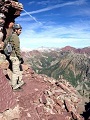
Castle summit " I was on Capitol, distant background, less than 24 hours earlier
Thumbnails for uploaded photos (click to open slideshow):
Nice trip report! I climbed Castle a number of years ago from Conundrum Hot Springs. Easily one of the least enjoyable 14er routes I've done! Sadly, I didn't get to cross over to Conundrum. I'm hoping to make it back this fall. Was there much car camping up the Montezuma road? Thanks!
Nice meeting you on the summits. Luckily ”the dudes” stopped kicking rock down as we followed your descent route. Thanks for taking the lead, that definitely saved some time!
To the car camping question, there are lots of great sites between around 10,900 and 11,500.
My boyfriend and I shared the summit of Castle with you and took your pic! Great recap. After Conundrum we opted to hike back up Castle which took us about 45 minutes. With people coming down Castle we had to be really careful about the loose rocks and we were glad to have our helmets on. All in all a great day, we parked just below the pass too and weren't moving quite as fast as you so we were glad to have started a little earlier. Congrats on the great weekend of C-cubed!
I'm glad actually to hear from someone who took the other route back down. Honestly, after seeing ”the dudes,” fear of rockfall on both the NW and NE ridges, as well as the loose sections is what made me decide to descend via the saddle.
I am coming from the East coast looking to make this climb tues, aug 19 - will be driving a rental car - is the lower parking right at the castle creek road & intersection of Montezuma? (as shown on google maps) thanks. derek
Caution: The information contained in this report may not be accurate and should not be the only resource used in preparation for your climb. Failure to have the necessary experience, physical conditioning, supplies or equipment can result in injury or death. 14ers.com and the author(s) of this report provide no warranties, either express or implied, that the information provided is accurate or reliable. By using the information provided, you agree to indemnify and hold harmless 14ers.com and the report author(s) with respect to any claims and demands against them, including any attorney fees and expenses. Please read the 14ers.com Safety and Disclaimer pages for more information.
Please respect private property: 14ers.com supports the rights of private landowners to determine how and by whom their land will be used. In Colorado, it is your responsibility to determine if land is private and to obtain the appropriate permission before entering the property.


 Snowfield")
 Castle NE ridge")
 Saddle descent")
 Castle NW ridge")
 Castle summit")