Download Agreement, Release, and Acknowledgement of Risk:
You (the person requesting this file download) fully understand mountain climbing ("Activity") involves risks and dangers of serious bodily injury, including permanent disability, paralysis, and death ("Risks") and you fully accept and assume all such risks and all responsibility for losses, costs, and damages you incur as a result of your participation in this Activity.
You acknowledge that information in the file you have chosen to download may not be accurate and may contain errors. You agree to assume all risks when using this information and agree to release and discharge 14ers.com, 14ers Inc. and the author(s) of such information (collectively, the "Released Parties").
You hereby discharge the Released Parties from all damages, actions, claims and liabilities of any nature, specifically including, but not limited to, damages, actions, claims and liabilities arising from or related to the negligence of the Released Parties. You further agree to indemnify, hold harmless and defend 14ers.com, 14ers Inc. and each of the other Released Parties from and against any loss, damage, liability and expense, including costs and attorney fees, incurred by 14ers.com, 14ers Inc. or any of the other Released Parties as a result of you using information provided on the 14ers.com or 14ers Inc. websites.
You have read this agreement, fully understand its terms and intend it to be a complete and unconditional release of all liability to the greatest extent allowed by law and agree that if any portion of this agreement is held to be invalid the balance, notwithstanding, shall continue in full force and effect.
By clicking "OK" you agree to these terms. If you DO NOT agree, click "Cancel"...
It was time for Abe and I to reunite and when you add vert monster + vert monster you get one helluva a big day. I was in the mood to peak bag and a peak baggin' we did. We came, we cleaned house, we left. Part 2 of my adventure continues now.........
After leaving Wetterhorn Basin, for several reasons I caved and went back to Gunnison where I got a discounted (I am good at bargaining) hotel room for the night. It was the best shower of my life. Sunday morning I woke up refreshed and ready to drive to Creede. I had no plan but to make the drive as fun as possible because really I am nothing more than a dirty little fun haver. I started by driving 50 to the Lake City cutoff. As I drove the dirt road that connects to 149 my interests were sparked by the hills to my left. Eventually I found a low point with an accessible trail and pulled over. It would not be an adventure unless I ran up some random hump in a bathing suit top and cut off shorts. Ended up being 1.2 miles with 550 feet of vertical gain.
The dirt road way of life. Random run views.
I continued on a beautiful drive to Lake City. I was falling in love with southwest Colorado. In Lake City I ate lunch at a place called Tic-Toc Diner and talked to two locals who told me to go to campsite 9 at Lake San Cristobal for some pretty amazing views, they weren't kidding. I also went for a polar bear swim while people gave me "you're crazy" looks.
Lake San Cristobal Camp spot 9 Polar bear polaroid.
I tore over Slumgullion Pass towards Santa Maria Lake. It was a complicated maze of dirt roads to get to this lake that is not exactly legal to see. The trout club did not seem to mind my presence.
Santa Maria Lake
Finally I headed toward Brown Lakes. Having gotten trespassing out of my system for the day I decided to stop where the signs told me to and have a snack.
Brown Lakes
My exploration ended at my final destination, Kips in Creede. What a FANTASTIC drive and enjoyable travel day. I met Abe and we had dinner before heading towards Equity Mine for a solid night of trunk sleeping.
Kips
Let me start off by saying that both Abe and I underestimated the point fest, I also believe we made it more technically challenging than it needed to be, and the rock we climbed is the worst I have encountered. There are rather sketchy parts to this tale but it was an absolutely epic day.
Stats:
19 miles
7,500 feet of gain
11 hours 45 minutes
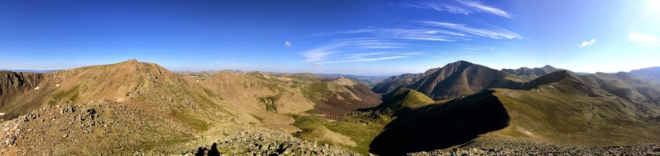
When you go with Abe you get cool drawings for your TR CO trail = Skyline Trail
We got a 5:15 a.m. start from the 4WD trailhead (do not attempt to get a 2WD up this road) and began the climb up Skyline Trail to San Luis Pass where we cut right or southeast towards our first objective PT 12,540. It was a class 2+ to 3 scramble up and down.
PT 12,540 Summit Down climbed.
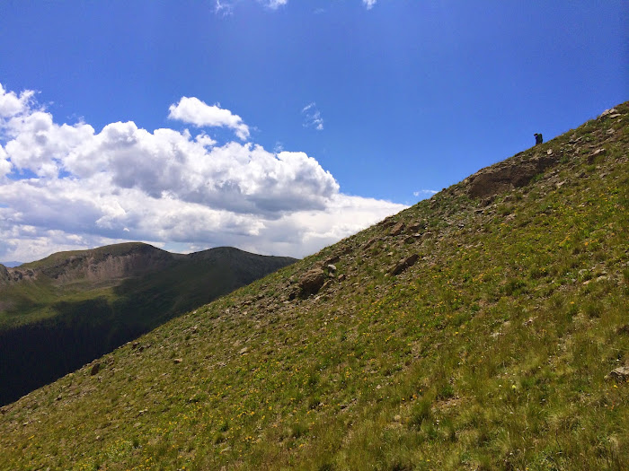
Next up was a nice long grassy slog from PT 12,540 to PT 13,100. We battled some willows and began gobbling vert down as the sun rose over San Luis Peak.
The ridge/route ahead. A look at the ridge difficulties to come. Vert monster 1 Vert monster 2 Summit of 13,100
Apparently 13,100 is a false summit of PT 13,285 but it sure as hell did not feel like that. There is another big loss and big gain on the way to this ranked 13er on more grass and then talus.
Interesting gnar on the way to 13,285 Abes Summit of PT 13,285
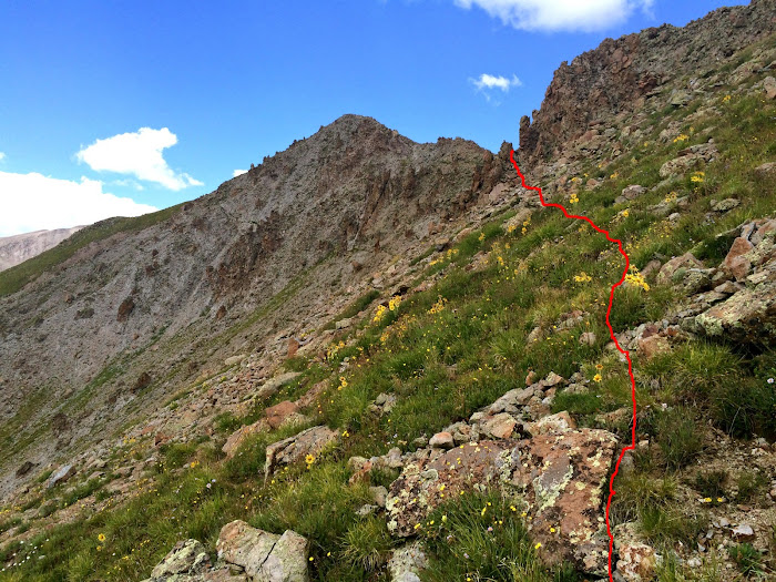
From 13,285 we headed northeast to PT 13,180. The route went from mellow to serious with the descent-ion of one grassy slope. We initially stayed south of ridge proper but eventually grew weary of the steep loose matter we were side hilling and ended up running out proper. There were small ups and downs but not as bad as if we had dropped far below (south side) to avoid the difficulties. This is an option but we came to scramble. Route finding was challenging.
Abe's initial investigation. Part of the route. My ass only shoots out rays of sunshine. It was loose. And steep.
During this down climb Abe sent a basketball sized bomb my way. Luckily I was able to deflect it with my man hands.
A look back.
We reached the summit of PT 13,180 thoroughly impressed by the ridge.
San Luis
We headed for the summit of the intimidating PT 12,935.
To PT 12,935, PT 13,155 in the background. A look back. Peak number 5 One big hump.
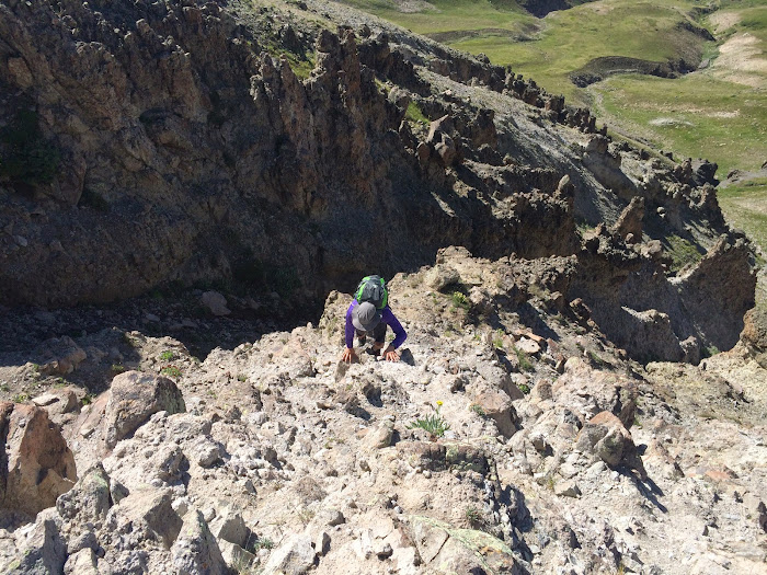
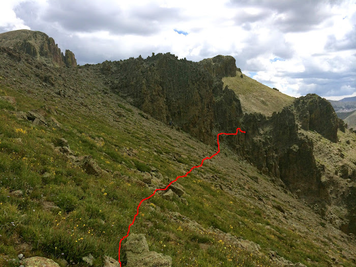
From PT 12,935 we made our way to PT 13,155. It started out as mellow grass but there was a chunk of not so mellow grass that blocked easy passage. To keep this as an annoying loose down climb skirt all difficulties to the south (right) and then climb back up to gain the ridge. This will require a big drop and neither Abe nor I wanted that. Since we had a good time on the previous section of climbable ridge we decided to see what ridge proper had to offer. BAD NEWS! I went first and climbed a large gendarme and then began traversing around it. Simultaneously my hand hold disintegrated and my foot hold popped and for a split second I was holding on to nothing. The exposure was terrifying and I was incredibly shaken up. It did not stop there. We were now in a position where rock was literally crumbling with the slightest of touch. Not many pictures from this section and I cannot really explain what we did because I was in survival mode but if doing this route I would recommend dropping, it was not very fun.
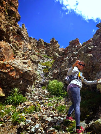
Craptastic Coming up this gully induced hyperventilation and tears. The final section.
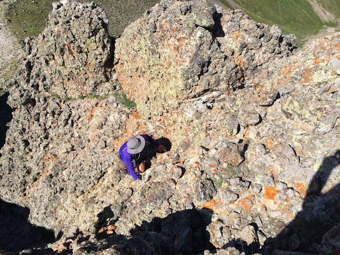
Once that horror was behind us we powered up to the base of PT 13,155. Abe took the route lined in red on the south side and I wrapped around to the north side and climbed an extremely exposed 40 foot wall. The rock was bomber, so the climb was enjoyable but don't stub a toe or anything on the way up and down this odd rock formation.
Abe's Route
My wall
Abe hates summit shots so naturally I will post any I have of him.
From the summit of 13,155 we descended 535 feet to the 12,650 foot saddle where we developed a super awesome game plan to charge the 1,400 feet to the summit of San Luis. Abe made it in 33 minutes and myself 42. It was fun, we love vert.
Abe loves this picture he took of me about to summit.
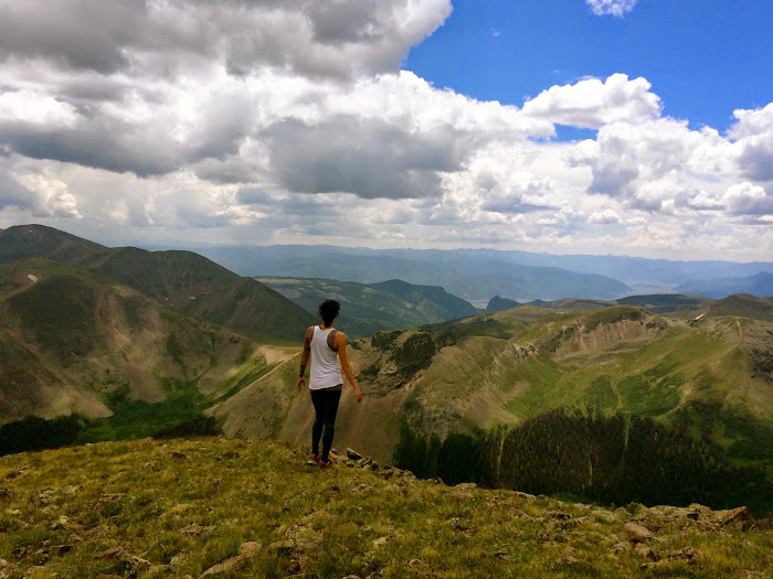
On the summit I activated my own super awesome plan and forced Abe into the most touristy summit photos possible. Win!
Summit of San Luis Peak!!!
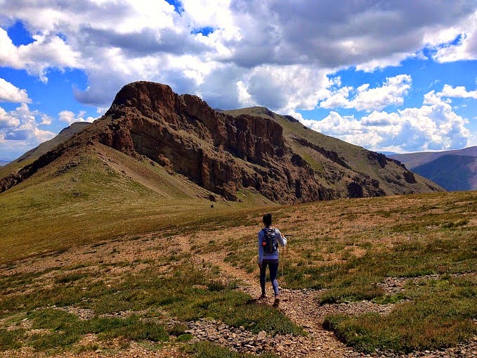
Organ Mountain
There had been undertones of Organ Mountain all day. Abe kept saying, "it's so far away." We were about to change that. I was overly nervous and excited because I had done my research which produced a lot of failed attempts to run the ridge between because of the giant and dreaded gash. We were on the same page from the moment we started point fest, we wanted San Luis to Organ more than anything else that day so it would have taken a big event to shut us down. We charged off San Luis.
In the saddle between San Luis and Organ, we skirted this mess of cliffs to the left (north) side
Staying as high as we were allowed.
After the initial bypass the terrain becomes grassy up to a false summit.
After going up and over the false summit the ridge narrows to a cat walk.
It was instinctual where we should start to drop off the ridge, not because the ridge becomes un-doable, not because you can see the gash, but because there are heavy gates guarding the gash and I recognized them from pictures. Initial drop.
Abe wanted to stay as high as possible and offered to do investigative work so I agreed as long as we kept things manageable. His route finding skills were impeccable. The key to maneuvering the gash is not to drop as low as you would imagine. The gates guarding the gash, we stayed quite high.
In the first traverse.
Down climb in to gash.
The climb out of the gash, very fun!
Working on regaining the ridge, loose and steep.
More loose
After the gash the final grass stretch towards organ.
The gully between the V notch.
We stayed to the right of the gully and had a blast scrambling up very solid class 3 rock to the summit. This was my favorite scrambling of the entire trip. If doing this route stay right to avoid the loose crap in the middle.
And then the summit...
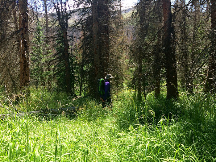
Climbing Organ from San Luis (the west) presents a real mountain challenge, complete with difficult scrambling and route finding while the other side (east/northeast) is a grassy mellow walk up. We talked about possible exit routes and decided on down climbing the fun class 3 and returning to the saddle with the false summit before the gash. From here we used the steep and trying southwest gully to descend in to the trees where we picked up the skyline trail. We were three mountain passes and three basins away from Abe's truck and our ticket out.
Initial descent, we shot for the patch of dead trees.
A look back at Organ.
Fun times.
Working towards the trail.
Wouldn't be an adventure without a bushwhack.
We had put in a lot of work for the day and the sun was beating down upon us frying our weakened brains. My black head of hair was sizzling my smart cells. Delirium set in as we got in the rhythm of going up. We were at about 11,400 feet and had to gain the 12,620 foot saddle between San Luis and PT 13,155. So, around 1,200 feet of gain at the end of a huge day and that was just pass number one.
Trail time.
One ember away from a major fire event.
One last look at Organ.
After gaining the first pass a cloud covered the sun allowing for short lived relief. We looked across the valley and saw the next pass. A good trail worked with the circ of the mountain as to not throw away precious elevation gain. I should mention that my dear friend Abe is currently dealing with two torn ligaments in his knee. To complete this day is a testament to how strong he is. When the trail flattened out a bit we ran.
Looking towards the second pass, the most mellow of the three.
From the second pass we could see the route ahead and San Luis pass, the final amount of upness we would have to tackle. We were both in good spirits, on our second wind, and mostly running it out. It was about 700 feet of gain and then the homestretch. We got back to the truck around 5:40 p.m. and gave a mother, son, and dog a ride to their 2WD car.
A look at the ridge between 13,285' and 13,180'
Final Climb
We went back to Kips (I LOVE CREEDE), each had two dinners and made friends with two drunk backpackers. It started to rain and we said goodbye, Abe heading to the Sawatchers to do my Shav/Tab day and I headed to Crestone to visit a friend and perhaps run a peak. This was a fantastic day.
To Be Continued......
Thumbnails for uploaded photos (click to open slideshow):
Caution: The information contained in this report may not be accurate and should not be the only resource used in preparation for your climb. Failure to have the necessary experience, physical conditioning, supplies or equipment can result in injury or death. 14ers.com and the author(s) of this report provide no warranties, either express or implied, that the information provided is accurate or reliable. By using the information provided, you agree to indemnify and hold harmless 14ers.com and the report author(s) with respect to any claims and demands against them, including any attorney fees and expenses. Please read the 14ers.com Safety and Disclaimer pages for more information.
Please respect private property: 14ers.com supports the rights of private landowners to determine how and by whom their land will be used. In Colorado, it is your responsibility to determine if land is private and to obtain the appropriate permission before entering the property.


 The dirt road way of life.")
 Random run views.")
")
 Lake San Cristobal")
")
")
")
 Camp spot 9")
")
 Polar bear polaroid.")
")
 Santa Maria Lake")
 Brown Lakes")
")
")
 Kips")
 PT 12,540")
")
 Summit")
 Down climbed.")
 A look at the ridge difficulties to come.")
 Vert monster 1")
 Vert monster 2")
 Summit of 13,100")
 Interesting gnar on the way to 13,285")
 Abes")
")
 Summit of PT 13,285")
 Abe's initial investigation.")
")
 Part of the route.")
 My ass only shoots out rays of sunshine.")
 It was loose.")
 And steep.")
")
")
 A look back.")
 San Luis")
")
")


