Download Agreement, Release, and Acknowledgement of Risk:
You (the person requesting this file download) fully understand mountain climbing ("Activity") involves risks and dangers of serious bodily injury, including permanent disability, paralysis, and death ("Risks") and you fully accept and assume all such risks and all responsibility for losses, costs, and damages you incur as a result of your participation in this Activity.
You acknowledge that information in the file you have chosen to download may not be accurate and may contain errors. You agree to assume all risks when using this information and agree to release and discharge 14ers.com, 14ers Inc. and the author(s) of such information (collectively, the "Released Parties").
You hereby discharge the Released Parties from all damages, actions, claims and liabilities of any nature, specifically including, but not limited to, damages, actions, claims and liabilities arising from or related to the negligence of the Released Parties. You further agree to indemnify, hold harmless and defend 14ers.com, 14ers Inc. and each of the other Released Parties from and against any loss, damage, liability and expense, including costs and attorney fees, incurred by 14ers.com, 14ers Inc. or any of the other Released Parties as a result of you using information provided on the 14ers.com or 14ers Inc. websites.
You have read this agreement, fully understand its terms and intend it to be a complete and unconditional release of all liability to the greatest extent allowed by law and agree that if any portion of this agreement is held to be invalid the balance, notwithstanding, shall continue in full force and effect.
By clicking "OK" you agree to these terms. If you DO NOT agree, click "Cancel"...
I sent this pic of me to my mom/sibs explaining that it was safe. One sister said, "I can see that it's safe, AS LONG AS YOU
Stats
(some times are approx, and lots of time taken for pictures and exploring! Guessing hiking time 3 hrs up, 2 down)
TH 4WD lot - 6:00 am
Rock garden - 7:30a
Yellow dirt - 8:15a
Top - 9:40a
Depart top - 10:15a
Parking lot - 1:15p
Elevation: 10,800 to 14,015. Gain: 3300
Distance: 7.0 mi RT
Two-minute Drill
If you're new to Class 3 and haven't yet nabbed Wetterhorn, Just Do It! The hike/climb is relatively short, the views in the San Juans are remarkable, and the mountain itself is dramatic and just not all that dangerous under the right conditions. Sure, there is some exposure, but that is mostly a psychological obstacle. The rock is solid, and you can make a fairly hasty retreat if weather is threatening. Wetterhorn moves into my #2 favorite 14er slot - not quite able to displace Longs at #1. But, if you prefer a shorter hike, Wetterhorn is a winner.
Intro
This exceptional climb had two primary objectives as I was entering new territory in my fitness/experience progression. I was trying to get some more Class 3 under my belt by adding to my other Class 3 climbs that included Kelso Ridge a couple weeks earlier and Longs from 2013. But perhaps more importantly, of my previous 19 14er summits which didn't really begin in earnest until 2013, I had not yet hiked two of them on consecutive days - and I wasn't at all sure that I could. My plan for this solo San Juan weekend was to climb Wetterhorn on Saturday, and then get the Redcloud/Sunshine combo on Sunday. Additionally, it was important to me to get all three from an efficiency standpoint since it's a five hour drive from Louisville and I had hiked Uncompahgre and Handies on separate occasions in 2013 and 2012 with each of my two sons and thus hoped to finish the 'Lake City 5' this weekend.
Mission accomplished! The Redcloud/Sunshine hike will probably be covered in a separate trip report - but only because I selected the non-standard route off of Sunshine which was ... different.
The Drive (Friday 8/8/14)
I chose the "scenic route" from Lville which meant the usual trip down 285 to Salida on Friday, but then included the more circuitous but worthy path through Creede on my way to Lake City. I stopped in Salida for a couple of hours where I enjoyed lunch w/ my oldest son who happened to be there that day to perform at a local bar. Salida is a cool town and I wished that I had more time to spend there but I had to keep moving to get to LC and up the 4WD road by nightfall.
Nice little detour through Creede the night before the hike. Between Creede and LC. Def check this route out if you have time. Talk about earthtones. I want a flannel shirt with these
My plan was to pitch my tent near the parking lot at the top as I figured that there would be a few sites and some other campers up there as well. To my chagrin, there was only one vehicle parked up top at 8 PM with no sign of any occupants. Decent camping options were not apparent around the lot so I drove back down to a patch of trees and a couple pullouts just below and backed my truck in with the intent to pitch my tent in a flat dirt area. Unfortunately, it was getting too dark to see and I'm afraid I'm a bit of a pansy anyway when it comes to camping alone as I'm convinced that a grizzly bear will make its way down from Yellowstone upon hearing that I'm in town and will swallow me and my tent whole. I would disappear w/o a trace and become the subject of a forum thread which would be potentially worse than the event itself. In retrospect, one might be better off parking lower about .7 miles at the "2WD" pullouts and save some wear and tear on your vehicle. There were several vehicles there and possibly a tent or two, but I can't remember exactly.
The Night
So I did something that I had dreaded almost as much as a bear, which was to sleep in the front seat of my truck. As I lay there, feeling safe but extremely uncomfortable, my thoughts went to the recent thread on porkies and other varmints crawling up into the engine block in search of salt or who knows what and chewing up brake lines and such. I guess certain trailheads have reputations for meddling wildlife. I didn't think Matterhorn TH was one of them which seemed a bit suspect to me since - don't critters live everywhere in the woods? I just knew that a prowling porky in the engine block would be my fate.
I lay there in my reclined seat, shifting my feet around on the dash in discomfort as the full moon emerged from behind a tree as if to improve its vantage point on my desperate situation. I may have nodded off for brief periods here and there. Sure enough, whatever sleep I may have gotten was rudely interrupted at 12:30a as I heard a rustling in the engine, only a foot away from where I reclined. I tried to pretend that it wasn't what I thought it was. Maybe it was just the wind. Until I heard it again. It was unmistakable. I had a critter. Damn! Why me? I fired up the truck, turned on the radio, banged on the dashboard, and smacked the front wheels w/ my trekking poles. Then I shined my flashlight on the ground hoping to see the rogue rodent amble off.
I had no idea if it had left me alone or not, but being the only vehicle around, I saw no reason why it wouldn't want to come back for another tasty treat, only now my engine would provide additional warmth. And it would be just my luck if the intruder shared my affinity for 70's music with a special preference for Heart's "Magazine". I debated driving back up to the parking lot proper but didn't wish to negotiate the nasty uphill drive in the dark and there was no way to tell if the creature had retreated. As I drifted in and out of consciousness, I was startled yet again around 3:30a as the noise in the engine this time was quite loud and sustained, forcing a repeat of the same procedures.
Needless to say, I got no restful sleep that night before my big climb and I still don't know if there was any damage, though a quick inspection in the daylight did not reveal anything amiss and I drove 250 miles home w/ no issues. I will offer that if you have an F150, you can raise the armrest, stuff sleeping bags, blankets, and pillows all around you, and lie sideways in the fetal position across the two front seats, albeit a bit awkwardly. At 5:00a, I finally drove up to the lot since two other vehicles had arrived in the night and I feared that the parking spaces would soon be gone and, if the varmint still *was* present, I wished to give him some other options ...
The Hike/Climb (Saturday 8/9/14)
I was hiking alone and chose to wait until there was some light in the sky around 6 AM. Before long, maybe 20 minutes or so, I made it to the fork that directs you off to the right.
Hmmm. Confusing. But .75 mi in and you don't want to miss it. Wetterhorn is scribbled in below. Go RIGHT!
The trail switch backs up the grassy hill and into the sparse evergreen forest. About an hour in, Wetterhorn was in plain view. I'm guessing that maybe 10 people or so took off earlier than I did, and I soon saw more folks coming up behind me on this Saturday in August, including a large group of 15 or so that was hiking to raise awareness for MS. I offered my services at the top as their photographer.
7:05a. (started at 6:00a) Wetterhorn bathed in sunlight and blue skies. 7:06a. Matterhorn. Don't confuse w/ Wetterhorn. Similar looking from some angles, Matterhorn is found to the right along a
"The Rock Garden"
Simply enchanting. Most 14er hikes have some sections that can be a bit of a slog. Not so on Wetterhorn. About 1.5 hrs in, you encounter what looks like a professionally landscaped rock garden with volcanic rocks of various sizes strategically placed, and large bouquets of columbines everywhere. The sweet spot for the Colorado state flower seems to be at 12k to 13k in August (I don't have much success w/ them at 5K). I had seen columbines in groups of four or five fairly regularly on other mountains this summer, but I couldn't remember seeing such large bunches of them. They are tended by blond-coated marmots which are also found in great abundance. I don't know what the story is with the lighter color, but it seemed like a different shade than usual.
The delightful Rock Garden. The marmots will show the way. I'd never seen so many columbine bouquets as I did this day. All over the Rock Garden. I'm often envious of the photos other folks seem to get of the flowers. I used my old Panasonic DMC-ZS1 and think I nabbed a Blond Marmot. Me: "Howdy Marmit". Him: "It's Mar-meaux. Good day sir!"
"The Yellow Rock"
I struggle w/ scree more than most but this wasn't *that* steep and, mostly, it was over in a jiff. And this patch adds to the diversity of the mountain. When no one was looking, I even slipped a small specimen into my pocket for later examination.
8:22a. The Yellow Rock. A little slippery w/ scree, but not too bad.
Into the Good Stuff
I had read carefully Bill Middlebrook's excellent route description and many of the summer trip reports and had this one all mapped out in my mind. With this knowledge, I felt a great deal of anticipation as I approached each feature in this jungle gym for big people.
Staying left of the ridge crest, it seemed difficult to get too lost here as I could kind of see a path, a few cairns, and w/ the "Prow" visible for much of the climb, I could figure the general direction I needed to go. There were a couple of spots where a rock might rise in front of me, blocking visibility of features above temporarily and requiring some fun scrambling. But after a few moves, I felt back on track again.
The first feature that felt like an old friend was the "A" that blocked the top of the main gully. This discovery was exciting, and an otherwise intimidating feature was rendered less so because I had a pretty good idea already of what I needed to do.
8:53a. The "A" at the top of the main gully.
You can either go left or right at this point, and both ways are intriguing. With the weather perfect at 9 AM and knowing that I was near the top, I took some time to explore the various options to see how things interconnected, so I'll try to capture some of that here.
Referring to the route description, "option 1" is to go left at the base of the "A" through a V-notch and drop down a few feet into a new gully, and start ascending again.
Option 1. Looking to the left of the "A", down into the next gully. Someone had put a pink flag there to mark the way. Looking back up at the Opt 1 exit in the previous picture. I think the pink flag again is lower right. A fun downclimb. No
I took option 1 on the way up, but option 2 seemed to be more popular, so I explored that one on descent. It tracks to the right of the "A", but is found about 20 feet before you get to the base of the "A". Ascend through a thin, but very doable staircase-like pathway:
The "A" is formed by two tall slabs. Opt 1 is at the base of the left slab. Opt 2 is 20 ft in front of the "A" to the right. *Not* Option 2. Looking down to the base of the "A" if you climbed vertically here. Difficult. Option 1 is just out of view
But it really didn't matter which way you went. Both options were fun and would essentially bring you around the 'A' to this place:
All options lead here. The "A" is below the large flat rock in center. Hard to get lost.
At that point, the "Prow" is visible and you cruise on up into the amphitheater. There's a fun and easy way to the top of the Prow which I'll share in just a bit.
9:22a. The "Prow" and surrounding amphitheater.
The "Prow"
The little amphitheater under the Prow seemed like a great gathering place as there were people coming and going, and a good spot to take a break and get ready for the grand finale. I ran into Kay ("GoingUp" - author of many colorfully entertaining and ambitious trip reports - who was actually headed down) and Senad (with whom I later enjoyed a beer) and I chatted w/ a fellow whom I ran into again the next day on Sunshine.
Let the Real Fun Begin! - The "Slab" and The "Staircase"
Next up was the climb up through the second notch to the right of the Prow to peer over onto the "Slab". The anticipation I felt here was similar to the build-up I felt on my first view of Longs' Keyhole. I actually took my time in order to savor the moment. I climbed up and peeked over. Whoa! There it was! The Slab in all its glory and the entrance to the "Staircase". I like that I can still feel the excitement of a child. However, I was perplexed to find missing a rounded rock that I expected to see jutting up perpendicularly from the middle of the Slab - maybe two feet tall or so. I think it's visible in 2012 and earlier photos w/ a prominent shadow, but seems to have disappeared in 2013.
Prow on the left. First notch to the immediate right of Prow. Correct 2nd notch is right of center. Two climbers can be seen 9:27a. The Slab w/ the Staircase up to the right. Nice!
To be honest, the Slab wasn't quite as steep as I had envisioned, although the picture may make it look so. I was able to comfortably walk up and down it w/o the butt slide move - maybe my new Moabs deserving of a shout out. And I have to add - though it's not necessarily rational - I felt more secure given that the drop off below the slab was not the unforgiving vertical face that I was expecting (like the wall w/ orange on it just beyond). Yes, falling off the slab might well have the same consequences, but it doesn't have the same psychological effect on me. This was also true for pretty much the remainder of the route up the staircase. I found myself finally coming to terms with the fact that, yes *great* care must be taken as the danger is very real on these parts of the mountain, but so much of one's trepidation is in the mind.
The Staircase was entertaining, and about midway up, I opted to take the nice ledge that traversed left to reveal probably the easiest way to the top. I took a number of pictures from various perspectives. Like many of the other photos I've seen, it's difficult to capture steepness and exposure accurately w/ the camera and it's all so subjective anyway. But I will say that, while I've gained recent experience w/ Class 3 and some technical climbing, I'm still no daredevil, and nothing about this section gave me pause. I just headed up and enjoyed it. I also wasn't overly concerned about getting back down - I descended face-in, face-out, and sideways as the situation dictated. Rain and limited visibility might change that.
Another look at the Staircase. The Slab is just below the picture. The top is just above.
Two ledges along the Staircase. I think I used the upper ledge to move left and continue on up.
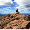
Me on the second ledge.
The top of the Staircase. The slope here looks less intimidating. Looking down the Staircase. The Slab can be seen upper left. Most of the route from above the "A" to top of the Staircase.
This was taken from other side of Prow as I climbed it. I'm thinking the Staircase is just left of ledges. Not sure.
My impromptu photographers Tom/Steve hangin' on the Slab. Kind enough to email some pix to me later.
Peak Panos
10:11a. Peak shot w/ Uncompahgre. Hiked that one in 2013 w/ my youngest son.
Coxcomb and Redcliff to the Northwest. Flowing rock glaciers and Silver Mtn to the Northeast. Matterhorn/Uncompahgre are off the frame to the right. A view SE down the Wetterhorn ridge and the trail below in the left valley. Redcloud/Sunshine are distant middle. Handies ma
Bonus scramble: Climbing the Prow
Since the weather was holding on the way back down, in addition to playing on the Stairway ledges, I decided to take a quick side trip up to the top of the Prow. It's straightforward. Just circle around to the right of it and a nice scramble will present itself up to the left.
The Prow
I raced these two guys who were roping to the top and beat them handily. Then I pretended that it was my medieval fortress and they were barbarians, and I pelted them w/ rocks. I think I hiked down part way w/ one of these guys. Pretty chill dude and a good hiking buddy.
Climbers trying to breach the castle walls. My position compromised, I held them off for a bit w/ primitive weaponry.
On the Way Out
It was kind of sad to be leaving this fine peak, but I felt really good about my day and I had another big day coming up on Redcloud and Sunshine. There were a couple of tents in the meadow above tree line which looked like a beautiful spot to camp.
Looking back up through the field to Wetterhorn.
12:30p. Wildflowers throughout.
Iron-stained creek. 1:14p. Parking lot.
As always, it was great to get back to the truck and begin the trek back to Lake City. After checking into a cabin, I met up w/ Senad at the Cannibal Grill, and enjoyed a big ol' honkin' sandwich and a cold brew. The weather was spectacular for the entire day and I couldn't have asked for a better drive and hike. This is one that is definitely worth revisiting.
Coxcomb, Redcliff, Wetterhorn the next day from Redcloud/Sunshine.
Outro - Comparison Time
I look forward to this because I've spent so much time researching trip reports and forum threads and getting the benefit of everyone else's perspectives. But I like being able to see for myself.
As mentioned previously, my database of Class 3 is somewhat limited, and includes Torreys' Kelso Ridge, Longs Peak, and now Wetterhorn. I think I have to rank Wetterhorn as the easiest of the three from an exposure standpoint, though I suppose it's possible that I would rank them differently if I had climbed Wetterhorn first. Longs I think is definitely the hardest because it is a much longer hike requiring significantly more endurance. It is also the most dangerous because the tougher sections after the Keyhole are so much more sustained. Kelso Ridge can be challenging because, unlike the other two, it is maybe steeper in sections and would be more difficult to retreat the way you came which is why most folks do Kelso as a loop. So it is more committing than Wetterhorn, and if a storm was moving in quickly, you might find yourself in more of a pickle than Longs simply because you might have to keep going up, but it's a much shorter hike so weather is more easily avoided. And my view of Kelso may be influenced by the fact that I was hiking with someone who had been there before and I just followed. All three require use of hands (that's why they're Class 3), but they all have stable rock and I never felt like I was hanging by a fingernail on any of them nor was I concerned about massive rock fall. But I wear a helmet to protect against banging my head on something and the occasional rock that gets sent down from above. In order of highest difficulty, I'd have to say: Longs (by far), Kelso Ridge, Wetterhorn.
Thumbnails for uploaded photos (click to open slideshow):
I love the pictures. It was nice meeting you on Wetterhorn and again on Sunshine.
I just climbed Longs last weekend and completely agree with your assessment of the difficulty of those 3 class 3 routes. I am going to give the Crestones a shot this weekend and I'll let you know how they compare!
for your nice comments OBC13, MNBW, SJ Ron, and James. For me, the views in the SJ's are the best! James, good to meet you as well and we seem to be climbing the same peaks as I went back and got Longs for the second time a couple of weeks ago. And I'd dearly love to hit one or both Crestones before the season is over but can't this wkend. Definitely let me know how it goes as soon as you do it and how it compares to the other Class 3's. I'm still ever so slightly fearful of the Needle but suspect that I may just find it fun and not as big a deal as I've built up in my mind - like the other Class 3's. btw you made the right call on heading back to RC from Sunshine. The non-standard route was a major hassle, though interesting.
Thanks for the great pics and tips! 8/29/2014 1:53am
Headed out to climb Wetterhorn this weekend as my first true class 3 so I really appreciate your photos and descriptions. I've climbed Lindsey and Kit Carson as difficult class 2 and am a little nervous about the top of Wetterhorn but you have the best pictures I've seen yet about the climb and it seems more manageable. Thanks for taking the time to put this all together. Your neighbor in Lafayette, Kate
Your detailed TR and captioned pictures are perfect! Wetterhorn will be our first Class 3, and I have been a little concerned about route finding on the way up and down -- this was very helpful, and very well-written! Thank you very much!
Lville, Ive posted a trip report on the Crestones. http://www.14ers.com/php14ers/tripreport.php?trip=15496. If you had no trouble with Wetterhorn and the prow, you'll like the Needle.
Caution: The information contained in this report may not be accurate and should not be the only resource used in preparation for your climb. Failure to have the necessary experience, physical conditioning, supplies or equipment can result in injury or death. 14ers.com and the author(s) of this report provide no warranties, either express or implied, that the information provided is accurate or reliable. By using the information provided, you agree to indemnify and hold harmless 14ers.com and the report author(s) with respect to any claims and demands against them, including any attorney fees and expenses. Please read the 14ers.com Safety and Disclaimer pages for more information.
Please respect private property: 14ers.com supports the rights of private landowners to determine how and by whom their land will be used. In Colorado, it is your responsibility to determine if land is private and to obtain the appropriate permission before entering the property.