Download Agreement, Release, and Acknowledgement of Risk:
You (the person requesting this file download) fully understand mountain climbing ("Activity") involves risks and dangers of serious bodily injury, including permanent disability, paralysis, and death ("Risks") and you fully accept and assume all such risks and all responsibility for losses, costs, and damages you incur as a result of your participation in this Activity.
You acknowledge that information in the file you have chosen to download may not be accurate and may contain errors. You agree to assume all risks when using this information and agree to release and discharge 14ers.com, 14ers Inc. and the author(s) of such information (collectively, the "Released Parties").
You hereby discharge the Released Parties from all damages, actions, claims and liabilities of any nature, specifically including, but not limited to, damages, actions, claims and liabilities arising from or related to the negligence of the Released Parties. You further agree to indemnify, hold harmless and defend 14ers.com, 14ers Inc. and each of the other Released Parties from and against any loss, damage, liability and expense, including costs and attorney fees, incurred by 14ers.com, 14ers Inc. or any of the other Released Parties as a result of you using information provided on the 14ers.com or 14ers Inc. websites.
You have read this agreement, fully understand its terms and intend it to be a complete and unconditional release of all liability to the greatest extent allowed by law and agree that if any portion of this agreement is held to be invalid the balance, notwithstanding, shall continue in full force and effect.
By clicking "OK" you agree to these terms. If you DO NOT agree, click "Cancel"...
The Citadel via East Ridge (3rd class)
Pettingell Peak via Citadel Traverse (3rd class w/rappel)
August 9, 2014
Partners: Emily & Paul
Looking for something fun to do that wasn't too far from home, I coordinated with some friendly 14ers.com members to hike the Citadel then over to Pettingell Peak. This route supposedly contained some good 3rd class terrain, options for 4th class as well as a rappel down a 5th class step so it sounded like a great way to spend the day.
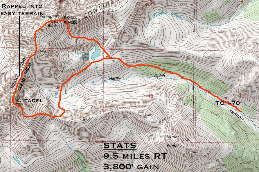
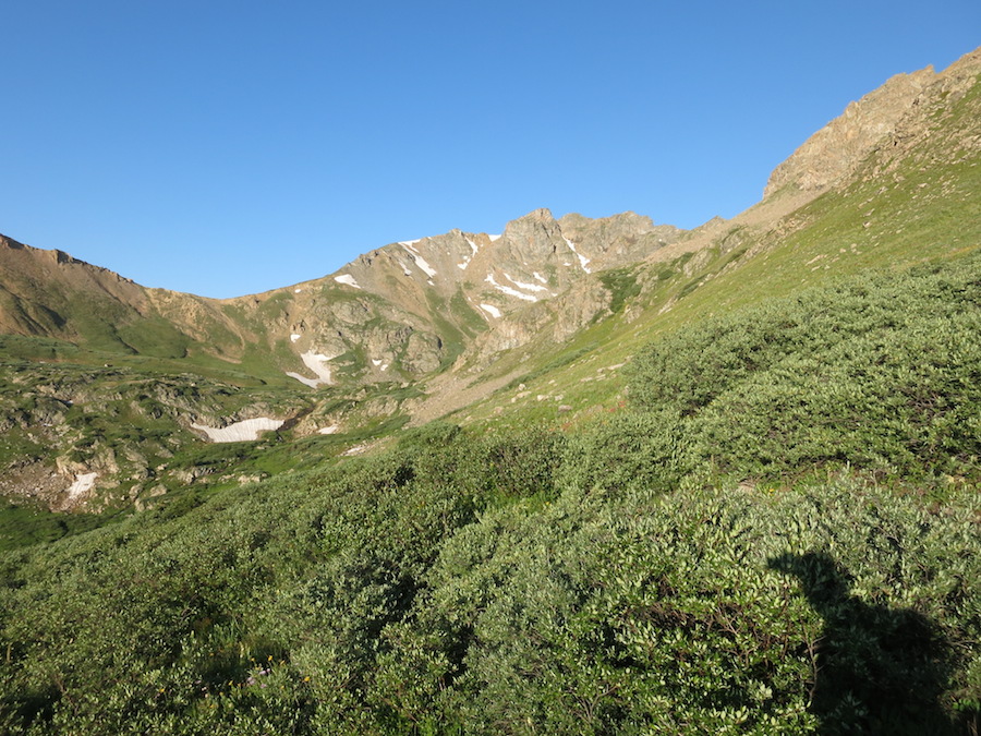
The forecast called for some definite storms in the early afternoon, so we arrived at the trailhead about half-past 5. The hike up Herman Gulch went smoothly and we soon were leaving the main trail right at Herman Lake. We followed the contour line as closely as possible, trying to not to lose any unnecessary elevation as we made over toward the obvious trail up to the Bethel/Citadel saddle. A few small sections of boggy ground and willows gave some opportunity for wet feet, but we manged without too much trouble and soon were standing at the saddle in a bitter wind.
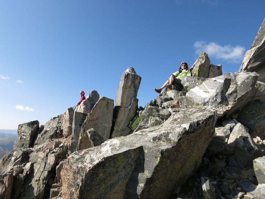
We followed the ridgeline up toward the Citadel, bypassing a small tower on the left. We opted to avoid the standard gully to the left and chose to scramble up harder terrain directly up to the Citadel's first summit. Other than the initial slope, the rock was generally good and we made good progress. The scramble over to the second summit was not a problem, although I suspected that it would have been easier to skirt around instead of climbing straight up. A small block makes the highest point and it was quite exposed trying to stand up on it against the blustery wind.
The building clouds kept us moving and we heading out toward Pettengell. Overall, the scrambling was much easier than we expected and after a short while we soon were standing at a bit of webbing marking the rappel point. Whoever had come before us had set a high anchor, and we scrambled further down to reach a lower anchor that consisted of a slung block/tunnel. The webbing looked good, but I backed it up anyway and soon sat at the bottom of the notch. Both Paul and Emily cruised through the rappel and we stashed our gear and motored onward. The final trek over to Pettingell went smoothly and we were surprised to see several people on it's summit. We lounged for a long time up top, but the weather drove us down. Decent scree made our progress fly by and the slopes down to the lake were very pleasant. Fortunately, the rain waited (other than a short hail) until we made it to the car and the lot was packed with cars. Overall, the scrambling had been much less challenging than I had expected and was much shorter as well. Regardless, it had been a fun day with great partners and a worthwhile way to spend a day in the hills.
***Note about the rappel. I had seen mixed reviews on the length of rope needed to get all the way down. Some trip reports mentioned using a 30M rope, one mentioned a 40M rope and others mentioned a 60M. I had originally brought a 30M, but after seeing a report where they had carried a 40M and clearly stated that it was not long enough, I opted to carry a 60M instead. Unfortunately, I did not measure the rope after making the rappel, but there was still a considerable amount of extra rope at the bottom of the notch. I would guess a 30M would be very, very close to making it, but the last few feet to the notch would be the most challenging to downclimb which could put a scrambler in a tough spot. Potentially by extending the anchor considerablly, a safe landing might be helped in a addition to a short rope.
Thanks for the report. Very interesting. I won't be doing this anytime soon so thanks
Caution: The information contained in this report may not be accurate and should not be the only resource used in preparation for your climb. Failure to have the necessary experience, physical conditioning, supplies or equipment can result in injury or death. 14ers.com and the author(s) of this report provide no warranties, either express or implied, that the information provided is accurate or reliable. By using the information provided, you agree to indemnify and hold harmless 14ers.com and the report author(s) with respect to any claims and demands against them, including any attorney fees and expenses. Please read the 14ers.com Safety and Disclaimer pages for more information.
Please respect private property: 14ers.com supports the rights of private landowners to determine how and by whom their land will be used. In Colorado, it is your responsibility to determine if land is private and to obtain the appropriate permission before entering the property.