Download Agreement, Release, and Acknowledgement of Risk:
You (the person requesting this file download) fully understand mountain climbing ("Activity") involves risks and dangers of serious bodily injury, including permanent disability, paralysis, and death ("Risks") and you fully accept and assume all such risks and all responsibility for losses, costs, and damages you incur as a result of your participation in this Activity.
You acknowledge that information in the file you have chosen to download may not be accurate and may contain errors. You agree to assume all risks when using this information and agree to release and discharge 14ers.com, 14ers Inc. and the author(s) of such information (collectively, the "Released Parties").
You hereby discharge the Released Parties from all damages, actions, claims and liabilities of any nature, specifically including, but not limited to, damages, actions, claims and liabilities arising from or related to the negligence of the Released Parties. You further agree to indemnify, hold harmless and defend 14ers.com, 14ers Inc. and each of the other Released Parties from and against any loss, damage, liability and expense, including costs and attorney fees, incurred by 14ers.com, 14ers Inc. or any of the other Released Parties as a result of you using information provided on the 14ers.com or 14ers Inc. websites.
You have read this agreement, fully understand its terms and intend it to be a complete and unconditional release of all liability to the greatest extent allowed by law and agree that if any portion of this agreement is held to be invalid the balance, notwithstanding, shall continue in full force and effect.
By clicking "OK" you agree to these terms. If you DO NOT agree, click "Cancel"...
I'm not one to write trip reports, but I've found that there is surprisingly little information on this route (considering how close it is Denver/Boulder). I doubt I actually picked the best way up and down, but figured it will at least provide a little help for people wanting to do this climb.
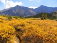
The trailhead
Take US-40 9.2 miles from I-70 and get off at the Henderson Mine Road. Shortly after you get on the road, take a left towards the Urad Mine and Urad Lake.
There is a big sign that warns you not to stop in the next 3 miles because you are on private property. Most of the trip reports that I read, it sounds like most people drove all the way up to the trailhead and parked in one of the pull-offs there. I wanted to be respectful and not be disruptive, so I parked in a little pull-off right before the sign. (Plus, the thought of having my car towed after a long hike didn't sound too appealing). I don't know how picky the mining operations actually are about people parking on the side of the road, but my personal recommendation would be to play it safe and park before you get to the private property. It doesn't add much too much distance the hike.
Hike up the road a little bit, passing some of the mining buildings and equipment, and you'll see a gate the warns of extreme avalanche danger. The trail starts right behind this gate.
Should go without saying, but use extreme caution if hiking this in the winter.
Up to Engelmann
The trail was pretty well established. Pretty soon, there was a fork in the trail and I took a left.
I was hoping that this trail would continue all the way to the top, but it suddenly seemed to stop.
I did some searching around, but couldn't find a continuation of the trail. There was a small bridge that the trail snaked back around on, but this appeared to lead to a cabin, presumably some private residence. I didn't want to bother anyone or trespass on somebody's property, so I turned around back to where the trail dead-ended.
I followed a couple of possible trails up, but they all seemed to die out. It's entirely possible I was missing something obvious (route-finding is not always one of my strengths), but I couldn't seem to find anything. Eventually, I decided to just continue heading up the creek without a trail.
Pretty soon, the creek got very rocky and a little more difficult to travel. Looking at the topo map, I knew that I would reach the saddle if I followed the creek all the way to the top. The terrain didn't look great, so I figured maybe I could head straight east up one of the avalanche chutes. I took one that was very steep, but had pretty good terrain. As long as I kept heading up, I would eventually reach the summit... right?
I took this all the way up Engelmann. It was very steep, but was a good hike up. There were very nice views when I got to the top.
View from the hike up A couple friends coming to visit Looking at Robeson, Bard, and Parnassus
On to Robeson and Bard
The way to get to Robeson and Bard were pretty self evident. It was just a matter of descending to the Robeson/Engelmann saddle, and then heading straight up Robeson.
Robeson wasn't much of a peak. I wasn't even sure when I was on the summit.
View from the top of Robeson
The rest of the way up Bard, I just stuck to the left to avoid any of the loose rocks on the ridge.
View from the top of Bard
Heading back
I wasn't sure if I should descend the same way I came up, since it would be a pretty steep hike down. Instead, I decided to go back to the Robeson/Engelmann saddle, and take the creek all the way down.
This was not an easy hike down. There were a lot of loose rocks, and it was very slow going.
Looking back at the terrain
Once I reached the creek, it actually got even more difficult. To stay by the creek, there was a lot of bushwhacking I needed to do, and it was pretty slick most of the way down. The sides of the creek were pretty steep, so I often had to hike down the creek itself.
Hope this isn't the remains of the last hiker to take this route
Eventually, I hit the trail (was very happy to see it!) and took the trail the rest of the way back down to the road. After I got back down to the road, it was just a matter of walking half a mile to get to my car. Was interesting to see some of the mining operations going on.
Some of the mining buildings
Conclusion
This was a really fun hike, but I found it more challenging than some of the other front range 13ers I've done in the area. It's entirely possible that there's a better way to get up Engelmann, but I didn't find it. My ascent was definitely more pleasant than the descent.
If you are wanting to just hike Bard, it would be much easier to do it via Parnassus from the Herman Gulch TH. You could do all 3 of these from Parnassus, but it would be a long way to traverse back.
Approximate route. Red = Ascent, Blue = Descent
Thumbnails for uploaded photos (click to open slideshow):
Yes, it's very possible to add Parnassus and Woods. I've read a couple reports of this. I maybe should have tried this, but it was already getting late. (Plus, I've already the two of them before).
One of the main challenges would probably just be being above treeline for so long. Would have to be an early start, and/or good weather. But once you make it up Parnassus, Woods is an easy climb. I just don't know what the descent looks like on the NE ridge.
Yes, it will be quite a stint above treeline. Jay is quite familiar with this area and he confirmed as well that the loop goes, so I hope to give it a shot soon.
Caution: The information contained in this report may not be accurate and should not be the only resource used in preparation for your climb. Failure to have the necessary experience, physical conditioning, supplies or equipment can result in injury or death. 14ers.com and the author(s) of this report provide no warranties, either express or implied, that the information provided is accurate or reliable. By using the information provided, you agree to indemnify and hold harmless 14ers.com and the report author(s) with respect to any claims and demands against them, including any attorney fees and expenses. Please read the 14ers.com Safety and Disclaimer pages for more information.
Please respect private property: 14ers.com supports the rights of private landowners to determine how and by whom their land will be used. In Colorado, it is your responsibility to determine if land is private and to obtain the appropriate permission before entering the property.


")
")
")
")
")
")
 View from the hike up")
 A couple friends coming to visit")
 Looking at Robeson, Bard, and Parnassus")
")
")
")
")
 View from the top of Robeson")
")
 View from the top of Bard")
")
 Looking back at the terrain")
")
 Hope this isn't the remains of the last hiker to take this route")
 Some of the mining buildings")
 Approximate route. Red = Ascent, Blue = Descent")