Download Agreement, Release, and Acknowledgement of Risk:
You (the person requesting this file download) fully understand mountain climbing ("Activity") involves risks and dangers of serious bodily injury, including permanent disability, paralysis, and death ("Risks") and you fully accept and assume all such risks and all responsibility for losses, costs, and damages you incur as a result of your participation in this Activity.
You acknowledge that information in the file you have chosen to download may not be accurate and may contain errors. You agree to assume all risks when using this information and agree to release and discharge 14ers.com, 14ers Inc. and the author(s) of such information (collectively, the "Released Parties").
You hereby discharge the Released Parties from all damages, actions, claims and liabilities of any nature, specifically including, but not limited to, damages, actions, claims and liabilities arising from or related to the negligence of the Released Parties. You further agree to indemnify, hold harmless and defend 14ers.com, 14ers Inc. and each of the other Released Parties from and against any loss, damage, liability and expense, including costs and attorney fees, incurred by 14ers.com, 14ers Inc. or any of the other Released Parties as a result of you using information provided on the 14ers.com or 14ers Inc. websites.
You have read this agreement, fully understand its terms and intend it to be a complete and unconditional release of all liability to the greatest extent allowed by law and agree that if any portion of this agreement is held to be invalid the balance, notwithstanding, shall continue in full force and effect.
By clicking "OK" you agree to these terms. If you DO NOT agree, click "Cancel"...
It's been a busy summer for climbing 14ers for me in the Sawatch, Mosquito, and San Juan ranges. I've been anxious to get back into the Elks, a little closer to home.
A friend of mine through Facebook, Nicole Deroeck had been asking me for beta on Snowmass Mountain a few weeks previous when she saw pictures that I had posted from an earlier trip there with Mike Zdero. She was looking to do something a little more difficult and the Elk mountain range seemed a likely candidate as it is near her home as well.
A little more complicated choice for another member of the climbing group was Mike Zdero. He's been a friend for a while now, but we didn't get along so well in the beginning. We met each other by blasting each other in the forum on 14ers.com. The argument we had went something like this (and I'm paraphrasing): Me - You're immature. Z - No you're immature. Me - I know you are, but what am I?! Z - Oh yeah!?
Clearly, I won the argument because of my superior knowledge of pre-pubescent banter. No problem, because those people in Cyberspace aren't real right? As fate would have it, we discovered that we both had reservations to hike Culebra the same day.
When the day arrived, I think we both looked to smooth things over, and it actually went quite well. He went on to also catch Red Mountain that day so he was going to be back to his car much later than me. As I was having an ice cold beer at my truck at the end of the hike, it occurred to me that he would probably like one too. I left one for him in a plastic bag filled with ice. We've been friends ever since. I bought his friendship with one beer. I hope he runs for office some day.
So fast forward to August of '14 and we've done a few peaks together. He posted something on his FB page that I responded to and I also said "What are you climbing this weekend?" He said "Huron". I came back with "I've got a better idea, give me a call." My phone rang within 30 seconds.
So the stage was set for the three of us to climb North Maroon peak. I had already climbed it twice and it has been amazing both times. Mike and I met up with Nicole at a park and ride in Glenwood Springs and rode together to the trailhead near Maroon Lake. We started down the trail at 2:56 a.m. It was the day before the full moon and the moon was behind the Bells as we moved towards them in the dark. The dark looming peaks in the distance were enough to already have Mike a little nervous. The plaque at the beginning of the trail that speaks of "The Deadly Bells" always brings a respectful pause to the beginning of the climb.
We made short work out of the first 1.75 miles to the turnoff near Crater Lake that takes you on the trail for Maroon Peak. We continued towards Buckskin pass for another .75 miles before turning left and dropping down to the creek at Minnehaha Gulch. The trail winds up from the stream through the trees before eventually arriving at the boulder field that separates North Maroon peak and the Sleeping Sexton. This is where we encountered the only real route finding issue of the day.
When crossing the boulder field, it's important to be able to see the cairns in the distance. It was still dark and very hard to see far enough ahead with the headlamps. We were on track about halfway across the boulder field and then somehow we lost site of cairns even with three sets of eyes and three headlamps. I looked ahead to the profile of the mountain and aimed for what I thought looked like the right place. I was wrong and realized the error when I came to grass and there was no trail in sight. Nicole followed me initially and then retreated back to where Mike was at. We stayed in voice contact, and I decided that the trail must be above where I was at. I scrambled up hill about 150 feet and finally came across the trail and then backtracked down it until I came to Nicole and Mike. Not a great time to get off track when we were still under headlamps, but it all worked out fine.
The trail traverses under the Northeast ridge and then starts climbing via switchbacks for several hundred feet until you reach a cliff band. Just short of the cliffs, the trail became quite gravelly and the footing became slippery.
A section just before the first gully.
Mike was getting concerned about how steep the trail was and then the thought of coming back down through the same area left him nervous about continuing. I convinced him that we needed to get to the corner of the cliff where the trail enters the first gully. He agreed because it was only a couple hundred feet away, and we decided to take a break there.
A break was exactly what was needed and with the first light of morning the first gully came into view.
Mike and me coming up through the first gully. Photo by Nicole
I think somewhere during that time we saw our first mountain goat. Nicole was pretty excited, because with all of her ascents of 13ers and 14ers she had still never seen one on a climb. Goats on the ledge
Her drought of goat sightings came to an end because they were all over this mountain! I think she was also pretty stoked about the views ahead and she was very comfortable on this terrain. Mike's tension started to ease as we were able to see the trail ahead and the next cliff band that we were aiming for.
Taking at look at the cliff band below the second gully. Photo by Mike ZNicole looking confident in the first gully.
We started up through the first gully and the trail switch backed it's way up to the second cliff band. Along the way it was becoming apparent that Mike was getting more comfortable the longer we were on this trail. There are cairns everywhere along the grassy trail and route finding was not too bad.
As we crossed to the left under the second cliff band, the second gully came into view. It's much steeper than the first gully, but by the time we were looking up through it, everybody was quite comfortable with the terrain. We headed up through it, and despite the fact that the trail is much less obvious, and route finding was more difficult, it was not a real problem. The second gullyClimber in the second gully
I showed them our next goal which was the notch on the ridgeline above. Just below the ridgeline
Even if we got off route once in a while it was ok with the next land mark always in view.
We reached the notch on the ridgeline and Snowmass Mountain and Capitol Peak came into view. Snowmass Mountain, looking through the Sleeping Sexton. Photo by Nicole
I think this is where the excitement really starts, when the views of other peaks inspire to move forward. Just about this time, I heard a noise right behind me. I turned around and was startled by a goat that was close enough to touch. Goat and trapped pika
He was above me and as I pulled out my camera to take a picture I noticed a pika that was trapped between him and me. That's the first time I've ever been able to get a picture of a pika.
The next goal was to get up onto the ridgeline. There is a section of rocks that you have to scramble up through to gain the ridge and the difficulty increases. Scrambling to the ridgeline
You have to angle your way towards the summit but occasionally you are blocked by a wall and the only option is to switchback to the right to gain a few more feet. This process repeats itself several times. I led the way, and I think initially Nicole and Mike were a little nervous. However, as we kept gaining altitude they were both gaining confidence, and I think they were both really starting to have fun doing it. By the time we gained the ridge, I think they were both ready for more!
Gaining the ridge marks the spot where you cross over from the East face onto the North face. The summit is now in view as well as the most difficult section ahead, The Class 4 chimney. The chimney moves up through the black cliffs that riddle the entire North face of the mountain. Nicole above the ridgelineThe black cliffs on the North Face
It's intimidating at first, but as you move closer to it, you start looking for possibilities and the easiest way up. When we arrived at the chimney, I could no longer detect any fears or anxiety from Mike, and Nicole was ready for the task at hand. It was all business and the attitude seemed to be "Lets get this done!" The first move at the bottom is probably the most difficult. It's quite a high step, and it takes a little bit of study and checking for hand and footholds. Me starting up through the chimney
Once you pick your first move, all the others just fall into place. Nicole followed in behind me and I held back so that I could show both of them options. Nicole and Mike in the chimneyNicole showing us how its doneMike coming out of the chimneyMike looking back down the chimneyOut of the chimney, taking a look at Snowmass and Capitol
I really think that this section is a real confidence booster once you realize that you can do it.
Topping out on the chimney leaves you with only one last landmark before reaching the summit. The push to the precipiceNicole in the stretch to the precipice
It's not even a difficult section, it's merely a point to take note of and know that you're almost there. It's called the precipice and I've also heard it called the catwalk. When you approach it, you can't even see it until you're standing on it. You look over the Southwest side of it and it's clear where it got it's name: it drops off of the back side for several hundred feet. It's a very dramatic place for a photo op. Nicole arrived there first, followed by Mike and me.Nicole on the precipiceMike and me crossing the catwalk. Photo by Nicole
We stepped off of the catwalk onto some pretty solid ground and we all knew that the last landmark before the summit was done. I looked at Nicole and Mike and said "There it is, take the summit." When you are this close, you quickly forget that it's hard to breathe, muscles and joints are aching, and sleep has escaped you. As they pressed forward, I started to think about how long we had been on the trail that morning. Mike turned back to look at me and shook his head as he turned back uphill. If a picture paints a thousand words, then an essay was written in his glance. We both understood all of the anxiety, the events, and the hard work that had brought us within steps of the summit.
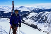
Nicole led the way and was pretty excited to reach the summit. Summit!!
Mike followed a minute or two behind and it was clear that this was no ordinary occasion. I think he was in disbelief that he had arrived on a peak that carried so much angst and mystique for so many years. Mike reaching the summit. Photo by NicoleDisbelief. Photo by Nicole
I would have to agree that it's one of the most special of all of the peaks that I've done.
The time was 9:15 a.m. and the weather was perfect with no wind. Phone calls were in order, snacks, pictures, and celebration. We started back down at 9:52 a.m. It was a relaxing time to go down with no real threat of weather. Mike entertained Nicole and me with his stories of earlier adventures. He does some pretty good voices too by the way! We had to put rain jackets on just before the stream at the bottom, but they came off quickly as the sun came out. By Crater Lake
A stop at Crater lake was in order for a quick break and then finally back to the car at 3:50 p.m. Certainly, a climb to remember! Thanks for a great time Nicole and Mike!
Thumbnails for uploaded photos (click to open slideshow):
I am so looking forward to this peak. Thanks for the write up. Wish I could've gotten off work for this trip! Maybe you'll repeat it with me 4th time's a charm!
@ davisrice4 - I wouldn't really compare the gullies on North Maroon to the Crestone Peak gully. North is quite a bit steeper, but there is grass throughout most of it so there is not quite the same danger of rockfall. Crestone Peak's red gully is not as steep, however it is very loose. When I came down it, I accidentally stepped on a loose rock and it slid out and took off down the gully. There were six people in the gully and fortunately they were all up close to me so no one was hurt. Even though the Maroon's are very loose, the red gully is nothing to mess around with. @ Lady McClimbsalot - You know I will! ....as long as you've replaced your climbing gloves. Lol
Mike, this TR is very helpful as my friend and I are heading out to traverse from N to S tomorrow. Your route pictures of critical areas are especially helpful. Goes to show everyone that a great TR will benefit someone years in the future.
Caution: The information contained in this report may not be accurate and should not be the only resource used in preparation for your climb. Failure to have the necessary experience, physical conditioning, supplies or equipment can result in injury or death. 14ers.com and the author(s) of this report provide no warranties, either express or implied, that the information provided is accurate or reliable. By using the information provided, you agree to indemnify and hold harmless 14ers.com and the report author(s) with respect to any claims and demands against them, including any attorney fees and expenses. Please read the 14ers.com Safety and Disclaimer pages for more information.
Please respect private property: 14ers.com supports the rights of private landowners to determine how and by whom their land will be used. In Colorado, it is your responsibility to determine if land is private and to obtain the appropriate permission before entering the property.


 A section just before the first gully.")
 Mike and me coming up through the first gully. Photo by Nicole")
 Taking at look at the cliff band below the second gully. Photo by Mike Z")
 Nicole looking confident in the first gully.")
 The second gully")
")
 Goats on the ledge")
")
 Climber in the second gully")
 Just below the ridgeline")
 Snowmass Mountain, looking through the Sleeping Sexton. Photo by Nicole")
 Goat and trapped pika")
 Scrambling to the ridgeline")
 Nicole above the ridgeline")
 The black cliffs on the North Face")
 Me starting up through the chimney")
 Nicole and Mike in the chimney")
 Nicole showing us how its done")
 Mike coming out of the chimney")
 Mike looking back down the chimney")
 Out of the chimney, taking a look at Snowmass and Capitol")
 The push to the precipice")
")
 Nicole in the stretch to the precipice")
 Nicole on the precipice")
 Mike and me crossing the catwalk. Photo by Nicole")
 Summit!!")
 Mike reaching the summit. Photo by Nicole")
 Disbelief. Photo by Nicole")
 By Crater Lake")
 File photo from 9/18/2011")