Download Agreement, Release, and Acknowledgement of Risk:
You (the person requesting this file download) fully understand mountain climbing ("Activity") involves risks and dangers of serious bodily injury, including permanent disability, paralysis, and death ("Risks") and you fully accept and assume all such risks and all responsibility for losses, costs, and damages you incur as a result of your participation in this Activity.
You acknowledge that information in the file you have chosen to download may not be accurate and may contain errors. You agree to assume all risks when using this information and agree to release and discharge 14ers.com, 14ers Inc. and the author(s) of such information (collectively, the "Released Parties").
You hereby discharge the Released Parties from all damages, actions, claims and liabilities of any nature, specifically including, but not limited to, damages, actions, claims and liabilities arising from or related to the negligence of the Released Parties. You further agree to indemnify, hold harmless and defend 14ers.com, 14ers Inc. and each of the other Released Parties from and against any loss, damage, liability and expense, including costs and attorney fees, incurred by 14ers.com, 14ers Inc. or any of the other Released Parties as a result of you using information provided on the 14ers.com or 14ers Inc. websites.
You have read this agreement, fully understand its terms and intend it to be a complete and unconditional release of all liability to the greatest extent allowed by law and agree that if any portion of this agreement is held to be invalid the balance, notwithstanding, shall continue in full force and effect.
By clicking "OK" you agree to these terms. If you DO NOT agree, click "Cancel"...
Here's the 3rd and final installment for my recent run of trips to the Gore Range. And I saved the most memorable for last. My brother, the Marine Captain, Uncle John, paid us a visit to meet his niece and nephew. He also mentioned wanting to "climb something awesome". I'm typed out at this point so I'll let pictures do the talking...
Day 1..Thursday, 8/28
8 miles, 4400 feet
Pitkin Lake TH (12:15p)
Pitkin Lake Trail to Camp at Pitkin Lake (2:45p)
Northeast Face of Outpost Peak
Outpost Peak (6:15p)
Day 2..Friday, 8/29
8.5 miles, 4200 feet
Depart Camp and Traverse Around South Ridge of East Partner (6:30a)
Usable Pass Basin to Usable Pass (no trail)
Descend Towards Boulder Creek and Regain Peak X's Southwest Ridge
Peak X (9:30a)
Peak Y (10:15a)
Peak Z (10:50a)
Peak Z Prime (11:15a)
Descend Towards Boulder Creek and Make Way Back Towards Usable Pass
Ascend Usable Pass
Retrace Route Back to Camp
Return to Camp (2:30p)
Day 3..Saturday, 8/30
7.5 miles, 1800 feet
Depart Camp (6:30a)
Ascend into Partner Basin
Ascend Gully to Low Point on Ridge
South Ridge of East Partner Peak
East Partner (8:15a)
Descend South Ridge to Higher Gully, Descend Gully and Basin to Camp
Pack Up Camp and Descend Pitkin Lake Trail to TH
It rained on our entire approach to Pitkin Lake.
Admiring some waterfalls along the Pitkin Trai. We decided to pick John up a pair of rain pants in Frisco on our way to the trailhead. It was a good thing we did.
It was still raining when we got to the lake. Setting up a tent, in the rain, with limited use of our fingers was comical and painful. We both agreed we hadn't been that cold in a long time. We spent a couple hours huddled in the tent, clutching nalgenes with boiling water.
When the rain finally stopped, we walked around to take in our home for the next 2 nights. Pitkin Lake and West Partner Peak.
It was still early so we decided to check out Outpost Peak, a ranked 12er.
Our approximate route up the NE face.
The view behind us.
The climbing was more fun than expected. It was a little loose, but for the most part the scambling was really enjoyable.
John picking a steep line near the summit.
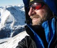
Mile High Salute
Once we got to the summit, a cool fog started to form in the valley.
By the time we started to head down the ridge, it had completely engulfed the Pitkin valley. John is down there somewhere.
The sun was teasing us on our way down the ridge so we decided to wait to see if would show itself below the clouds before setting.
It was worth the wait. Anyone know what that square-top rock is in the distance?
The next morning we worked our way around a ridge into the Usable Pass Basin. Here's John with Outpost in the distance.
I think this is Vista Pinnacle and Vista Peak. I was on that ridge a week earlier in a white-out and didn't see any of it.
John cresting Usable Pass.
Peak X. I learned from my mistake from last week. We descended a couple hundred feet on the east side and climbed just left of the obvious dirt gully.
The climbing on the south ridge of X is fun and not too difficult. There are sections like this if you want to spice it up a little, but it's not hard to keep the climbing at class 3.
John on the last stretch of ridge before the summit.
Summit of Peak X with B&B cairns...Peak Z and Z Prime in the distance. At this point we decided it would be best for John to descend back to the pass while I continued on to Z.
The scrambling definitely got more difficult as I continued on, but the route finding was pretty easy. I stayed on top of the ridge as much as possible. For the most part, any difficulties can be bypassed on the left.
The Peak Y, Peak Z saddle is a large notch...dark section in this picture. I dropped down to the right (south) before getting to this notch and regained the ridge on the other side.
Nearing the summit of Peak Z
Ridge to Z Prime...so fun.
A sampling of the ridge views you get on Z Prime.
I knew John was more than capable of descending Peak X's ridge and finding his way back to Usable Pass. But I couldn't help being nervous without being able to hear or see him. We both tried to yelling every once in a while. I was pretty sure I heard him on the ridge to Z Prime and I later found out that he heard me and could see me on that ridge. I guess those echoes don't travel as far as they sound like they do.
Here is the view of the pass from the Z, Z Prime saddle. From here I dropped down and tried to stay as close to the 2 high lakes as possible. I walked along edges of both of them. I was trying to avoid descending all the way down the the large lower lake, but a line of cliffs forced me down almost that low.
John on top of Usable Pass.
Usable Pass Basin
We got back to the tent just in time for another storm. It rained for almost 3 hours. Once the rain stopped we were determined to get a fire started. If you've ever camped near Pitkin Lake, you know there is a scarity of usable firewood. We searched far and wide for dead wood and ended up with a decent pile of soakng wet twigs and branches. Then in a moment of great brotherly triumph...we got that damn wood to burn.
We woke up the next morning to clear skies and decided to give East Partner a shot before hiking out. Here are the ascent and descent gullies we used. In my opinion, the hardest climbing on the ridge is between these 2 gullies.
Here is that section from the low point on the ridge.
Looking down at John climbing a steep gully in that same section of ridge.
Brothers on a ridge.
Awesome light on the Southern Gore Range
The description I had for the upper section of the ridge was pretty vague and a little confusing. It tells you to avoid some rock ribs on the right side and to ascend the final rib to the summit. The best description I can give is to stay on the right (east) side of the summit pyramid...staying at the line where rock and grass meets. Continue on this path, feeling like you are wrapping all the way around to the back of the peak. You almost go all the way to the NE ridge before you pick your line up some fun rock gullies that lead you to the summit.
Rocking out on the summit of East Partner.
John coming down the rock and grass line I was talking about with the NE ridge in the distance.
We made pretty quick work of the descent down the higher gully and were ahead of schedule, so we decided to take a dip in Pitkin Lake. This is John's version of the flying squirrel meets the swan dive.
Thanks for a great trip John. One I'll never forget.
Thumbnails for uploaded photos (click to open slideshow):
Great TR! Always glad to see pics of the Pitkin Ck area. That ”block in the distance” is Castle Peak (the other one), an old volcanic plug that is bordered on two sides by the Colorado and Eagle Rivers. That's a fun hike in itself.
It was pretty cool to get to ”meet” your kiddos and now your brother through these TRs, Mike. A huge congrats to you and Dani on the new additions... they are SO darn cute and will of course grow up to be formidable mountaineers, I'm sure.
PS: You are the undisputed king of the summit action shot.
Nice trip up Pitkin! The bad weather just made the pictures that much more beautiful! I've always wanted to know the pros and cons of a trip to Pk Z from from these drainages. Been over Usable Pass from Boulder Crk after climbing Pk X. It's not a tough climb at all from Pitkin, but the Boulder side is very steep looking!
Your 3 part tour in a month is what most of us do in a career!
Have been looking to X and Z before snow. Wasn't 100% sure whether the X-Y-Z ridge goes. Looks like it does!
Caution: The information contained in this report may not be accurate and should not be the only resource used in preparation for your climb. Failure to have the necessary experience, physical conditioning, supplies or equipment can result in injury or death. 14ers.com and the author(s) of this report provide no warranties, either express or implied, that the information provided is accurate or reliable. By using the information provided, you agree to indemnify and hold harmless 14ers.com and the report author(s) with respect to any claims and demands against them, including any attorney fees and expenses. Please read the 14ers.com Safety and Disclaimer pages for more information.
Please respect private property: 14ers.com supports the rights of private landowners to determine how and by whom their land will be used. In Colorado, it is your responsibility to determine if land is private and to obtain the appropriate permission before entering the property.


")
")
")
")
")
")
")
")
")
")
")
")
")
")
")
")
")
")
")
")
")
")
")
")
")
")
")
")
")
")
")
")
")
")
")
")
")
")
")
")