Download Agreement, Release, and Acknowledgement of Risk:
You (the person requesting this file download) fully understand mountain climbing ("Activity") involves risks and dangers of serious bodily injury, including permanent disability, paralysis, and death ("Risks") and you fully accept and assume all such risks and all responsibility for losses, costs, and damages you incur as a result of your participation in this Activity.
You acknowledge that information in the file you have chosen to download may not be accurate and may contain errors. You agree to assume all risks when using this information and agree to release and discharge 14ers.com, 14ers Inc. and the author(s) of such information (collectively, the "Released Parties").
You hereby discharge the Released Parties from all damages, actions, claims and liabilities of any nature, specifically including, but not limited to, damages, actions, claims and liabilities arising from or related to the negligence of the Released Parties. You further agree to indemnify, hold harmless and defend 14ers.com, 14ers Inc. and each of the other Released Parties from and against any loss, damage, liability and expense, including costs and attorney fees, incurred by 14ers.com, 14ers Inc. or any of the other Released Parties as a result of you using information provided on the 14ers.com or 14ers Inc. websites.
You have read this agreement, fully understand its terms and intend it to be a complete and unconditional release of all liability to the greatest extent allowed by law and agree that if any portion of this agreement is held to be invalid the balance, notwithstanding, shall continue in full force and effect.
By clicking "OK" you agree to these terms. If you DO NOT agree, click "Cancel"...
TH Elevation: 9,450 ft
Camping Elevation: ~11,500 ft
Summit Elevation: 14,137 ft
4wd TH to Campsite # 3: 6 mi, 3:35 (slow/moderate, with backpack), ~2600 ft gain
Campsite to Saddle: 0.75 mi, 0:55 (slower), ~1020 ft gain
Saddle to K2: ~1 mi, 1:15 (moderate), ~1170 ft gain
K2 to Summit: ~0.6 mi, 1:40 (slow/moderate), ~640 ft gain
Summit to K2: 1:30 (slow/moderate)
K2 to Saddle: 1:40 (slower)
Saddle to Campsite: 0:25 (fast)
Campsite to 4wd TH: 2:00 (faster, with backpack)
Preface
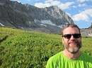
Since I've learned and heard about it, Capitol Peak has always instilled me with awe and respect. I've wondered for a while when I would be ready to climb it, and if that would be possibly this summer, or a few years in the future. When I climbed the Crestones, I felt a lot more prepared for steep, harder mountains. When I did Lindsey via the ridge route, I thoroughly enjoyed the ridge and the exposure, including the mini-knife edge and the class 4 crux. After that, I felt like I was perhaps up to the challenge of attempting Capitol. (after also reading many trip reports, and asking many questions in the forum). This last week, a good weather window appeared. It snowed about 3 inches on Tuesday, but the next few days would be sunny and relatively warm. I anxiously watched the weather, asking questions about how the peak looked from those who were nearby. After some good reports, I decided to go for it. On Friday, a fellow 14ers.com member, Malcolm Quentin, drove me from the Springs to Denver, where we met with John Nicholas, another 14ers.com member from Fort Collins. John had attempted Capitol in June this summer, but had to turn back because of deep snow. Malcolm hadn't yet attempted Capitol, but had done quite a few class 3 and 4 14ers so far. We got to the 4wd trailhead Friday afternoon, a little after 2 pm. Seeing the peak in the distance caused a wow reaction from all of us.. both from its grandeur, and from its steep north face and fear inducing knife edge.
Route Description
We took the Ditch Trail (Upper Capitol Creek Trail #1963) from the 4wd trailhead to the camp sites near the lake. It saves several hundred feet of elevation drop and regain, compared to the Capitol Creek Trail. The Ditch Trail is fairly well maintained for the most part, with not many rocks. It goes up gradually from the 4wd TH toward Capitol Lake, with a few gradual ups and downs.
One cool thing about the approach to Capitol is that you can see the peak all the way from the trailhead, and continue to see it as you hike closer. A handsome, awe-inspiring mountain.
Capitol Peak, N face. K2 is the bump on the left shoulder, the flat ridge has the 3 knife edges, and the route continues on t
The trail goes through aspens and meadows. You might also see some cattle lumbering along the trail, as I did on my way back. This is one of my favorite 14er approaches so far. It is beautiful.
At a little less than 3 miles, there is a turn-off to the left, which crosses a creek, then joins the Capitol Creek Trail. You might want to take your shoes and socks off as you cross the creek, depending on how high the water level is. There were two small logs where we crossed, which were barely above the water.
EDIT: Someone on the 14ers.com facebook page said that if you continue STRAIGHT at the Y, THEN turn left, there's a crossing. I think the gpx route from 14ers.com reflects that, too.
Turn-off to the left.. you can cross here, or there is possibly a better crossing if you go straight, then turn left to join Looking back at the creek crossing we took. Going straight at the Y is probably a better idea, because these are low and unst Junction sign
After you pass a sign stating camping is only allowed in designated spots, continue along the trail a little ways to a big meadow, where there will be trail spurs to the different camping spots.
The camping sign. Campsites are pretty close, to the right. Looking back along the trail by the creek The meadow near the camping areas. We camped in spot 3, to the right of the picture. Capitol Peak, above the meadow. Our camp site is behind.
If you head toward Capitol, there is a trail crossing. Left goes to the Daly-Capitol saddle, and straight goes to the lake.
Capitol Peak above Capitol Lake
Near out camp site was a guide and the climber she was guiding. She had guided many people up Denali, and had done Capitol 14 times so far. She gave us a lot of helpful advice.. After the saddle, either go down and across the gully, or continue traversing after the trail disappears, but don't climb too high, or you will be cliffed out. The standard route goes pretty far toward the snow fields on the distant ridge before turning to the right, toward K2. She recommended going up and over K2, then down to the right, in an area where there wasn't much snow. She said that after the knife edge, there were lots of cairns, so route finding wasn't much of a problem. (just finding safe ways to get to where the cairns were) After chatting for a bit, she encouraged us by saying, "We're going to be all right," then headed off to retire. I was able to rest more easily that night, knowing that with caution and respect for the mountain, summiting Capitol Peak and returning safely was possible.
We got up at 5, and at 5:40 on Saturday, 9/13, we headed towards the saddle. (a fairly late start, but the forecast was sunny with almost no chance of precipitation)
Capitol-Daly saddle The saddle from a rocky viewpoint from the south. The trail curves around the saddle.
The trail curves around the saddle, goes on for a bit, then seems to disappear. If you're in this area in the dark, this might be the hardest route-finding area. There are two options from here. About 100 feet before it disappears, there is a spur to the left. The spur goes downhill along several switchbacks, into a gully. You can descend the small gully, and look for a way to ascend the other side. The solid line indicates the way I ascended the gully, on the trip back from Capitol. (over a crack in the rock) A bit further down, there is a small rock cairn indicating another way to exit the gully. Once you exit, traverse around to the right, looking for more cairns. I didn't get a good view, but it might also be possible to go to the very bottom of the gully before turning right, if you can't find a good way out. You'll just lose a bit more elevation.
Looking down toward the switchbacks and the gully Possible options in the gully
If you want to lose less elevation, continue straight where the trail becomes undefined. You'll have to do a little class 3 scrambling over some rocks. Don't ascend, unless you want to do some more exposed scrambling above cliffs.. try to keep your elevation, or lose some as needed. Keep an eye out for cairns.
The straight, traverse option
After getting past the gully and rocks, I stayed low, following cairns as I went. You have to go pretty far, staying below the higher rock on the right, toward the distant snow fields under the ridge, before the route turns to the right toward K2.
The talus/boulder field. We stayed low, following cairns Continuing toward the distant snow fields, below higher rock, before turning right toward K2
Once you turn right, there will be larger boulders to go over, and you'll get a first glimpse of K2 in the distance.
First view of K2
A guide who has done Capitol 15 times suggested that we go over K2, then climb down to the right of K2. (There was some snow on the north face of K2, making a traverse of K2 more difficult. We found an area on the north face without snow for our descent) The front (east) face of K2 is class 4, the upper part is class 3.
K2
From K2, you have a great view of Capitol, and the daunting ridge below.
Capitol and the ridge from K2
There are actually three "knife edges." The first one has a very short knife area, with a lot more jagged/hand hold areas around it. The second knife edge is the classic knife edge, where most people take pictures. Each knife edge is separated from the other by a jagged area or two. I would highly recommend staying near or at the top of the ridge for all of the knife edges. On the edges themselves, you can hold the edge with your hands and stay on the left or right, or you can alternate using your hands and legs in a crab-walk fashion. There are a few areas where you can take a break and walk between the knife edges, but on the edges, don't try to avoid them by going down on the south side. (loose, very exposed). If you are comfortable with exposure, the knife edges aren't too bad. If you freak out with intense exposure, try to just focus on the next hand an foot-holds, and don't pay too much attention to the 1500+ ft drops on your left and right.
The second (and "classic") knife edge
After the knife edges, you have many options. You can ascend Capitol, staying closer to the ridge. Or, as we did, you can keep the same elevation for a bit, and follow the first cairns you see. Fortunately, there was almost no snow on this side of the peak. Only a few patches here and there, in the shadows or under rocks. Staying low, we were on a path of sorts.. scrambling around some ridges, we didn't gain too much elevation at first. We saw lots of cairns to guide us on this path. Keep paying attention and take care.. though there is less exposure, there is a lot of loose rock, and a hasty move could lead to a nasty fall. Your momentum from a fall would take you very far down in some areas.
EDIT: Cool Hand Luke suggested recently that, if you are okay with more sustained class 4 climbing and exposure, continuing to stay on the ridge proper all the way to the top is the way to go. The tradeoff is worth it, he says, because it avoids the common and dangerous rockfall on Capitol.
A look at the steep, fairly exposed traversing ahead The lower path we found
Eventually (if you are on the lower or middle route), you will come to a huge, steep face. The picture below shows possible options. We roughly followed the separated arrows on the left, while going up. (saw some cairns) Coming down, we followed the solid line in the middle. The solid line above on the right shows the path the middle route would take. Once you go across and to the left of the steep face, continue upwards. The ridge above you is the final ridge before the summit. You can go to the top of the ridge and do some level, exposed scrambling, or you can stay a little below the ridge, then head up toward the summit.
The steep face, with rock bands. Climbers are encircled. Looking back at the steep face, at the middle route, with the lower route below. A cairn is encircled. Looking down on the steep face, toward the lower route that we took. A cairn is encircled.
The steep face and the ridge above are some of the steeper areas we encountered on Capitol.
Looking down from above and to the right of the steep face, which is to the left. Looking down from above and to the right of the steep face, which is to the left.
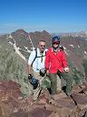
I felt pretty accomplished once I got to the summit!
Here are some summit views..
Looking NNW, Mt Sopris is on the left Looking NNE, Daly is on the right Looking NE. Daly is on the left, K2 is right of center Looking SE. N Maroon and Maroon are in the center, Snowmass is on the right
Once you're on the summit, you're only halfway done. All the up-climbing and traversing you just did, you now have to down-climb, which is more dangerous. Be slow, careful, and make sure to test holds, as some of the seemingly solid ones can be loose. The harder climbing is not over until after K2, so don't let up with your concentration. We took the lower route again, coming down.
I took the same way up and over K2. I went up the left (north) side, and down the east side.
K2. Because of snow, I climbed up the ledge on the left, then up beyond the ridge on the right
After K2, and in the boulder field again, follow cairns around to the right. Watch out, as much of the rock is unstable, shifting underneath you.
A hiker is encircled
Coming back to the saddle, I tried to take the same, lower route I took coming up. I followed cairns to a faint path beneath the rocky area, near the saddle. This route ended up crossing into the gully and going up it, before connecting with the saddle path. If you want to avoid the gully, I believe you would stay higher, on the grassy area. When in doubt, follow the cairns!
Once you're back to the saddle, you're back on an easy trail, stable earth, and can finally relax.
Final Thoughts
The most technical 14ers I had done before Capitol were the Crestones, the Lindsey ridge route, and Longs Peak. For Capitol, I'd recommend being comfortable with at least class 3 scrambling (some steep class 3 would be helpful). Bring the route description and pictures. Looking at the gpx file on google earth was very helpful for me in seeing the direction of the route. Good weather is very important for Capitol. After the saddle, you have many hours above treeline. On the ridge and the peak, you are especially exposed to weather. I'm very glad that the conditions were dry, and the weather was sunny when we hiked. If clouds are starting to form and getting dark, be very wary about continuing onward.
From K2 to the summit and back, be prepared for a slow, cautious climb. Though there are bigger, solid rocks on the face, there are also a lot of larger and smaller loose rocks. Test your holds, as some aren't as solid as you would think. The exposure is the worst on the ridge. I'm apparently very comfortable with exposure, as I was calm, at peace, and was able to concentrate well while crossing the knife edges. A few of my climbing partners were fairly shaken up. One had confessed to all of us before the climb that he was scared of heights. Concentrating on the small tasks at hand, like finding the next hand and footholds, helped him complete the ascent and descent. After the knife edges, there is less exposure, but a hasty move could lead to a slip and a fall - a fall which could continue for a while.
Overall, I found that Capitol was arduous, thrilling, had great views, and required caution and concentration. It wasn't as hard or intense as I thought it would be, and though it is difficult, it is not completely head and shoulders over some other 14ers. So I'd say if you're comfortable with class 3/4 and exposure, are in good shape, and know the route/are good at route finding, you are ready for Capitol. Definitely respect the mountain, the weather, and the conditions, and you are well on your way to safety, and therefore, success. If you have to turn around on any mountain, this is definitely a mountain worthy of trying again on a better day.
Thank you, Malcolm and John, for joining me and helping make this trip possible!
Thumbnails for uploaded photos (click to open slideshow):
Agreed, this is one of the best Capitol trip reports I have seen. I will hopefully be making a 2nd attempt on Cap (first attempt ended at the lake due to bad weather last Summer) in 2015, and I plan to print out some pictures from this Trip Report to help.
I will definitely use your report as a guide when I head to capitol later this month. The detailed description of the route really makes your report stand out. Congrats on an amazing achievement!
Thank you all! I feel honored, as this is only my second trip report. It did take me quite a while to write it up.
I feel responsible, now that people might print off and use some of the pictures I posted. Definitely use the 14ers route description, Roach's/Dawson's guides, and maps. I'll add a caution that the route pictures I posted are roughly, but may not be exactly, where we went. Use caution, pick a route that you're comfortable climbing up/down, and cairns are your friends. There might be easier routes than what we took. (the middle route on Capitol's south face might be easier, however, I found the lower route to be relatively pleasant.. traversing on a flat path, then climbing up steeper when you come to the steep face with the rock bands).
One thing I'll add, is to look at photo #3 in Bill's route description, and go to the RIGHT to continue following the Ditch Trail. We went on autopilot, and took a left instead. At a small stream crossing, there was a cairn, with a trail that went steeply up to the right to connect back with the main trail. (probably a social trail, made by others who missed the turn-off).
I would have liked to give a better return description, coming from the boulder field back to the saddle, but ran out of picture space. If you can remember the route you took while traversing/ascending after the saddle, you might be able to take that same route back. Otherwise, there were cairns that we followed that took us to the side of the gully you cross, and then go up.
Thanks again! If you're attempting Capitol, use caution and wisdom. It demands respect, but the summit IS attainable.
Thanks Ben. Great job on the trip report of our hike / climb. One thing I would add to your comment about being slow and deliberate between K2 and the summit is that the Class IV route is long and taxing on the mind, and once one reaches the summit, you have to get back to K2 before you may relax. It's a bit of a mental stress test, but really not so difficult technically if you have the prerequisite experience and take it one step at a time. Just be mentally prepared for a long focused climb from K2 and back.
Kudos for the very helpful and detailed report. My son and I hiked the following Saturday (9/20/14) and with the graphic,accurate photos,we really felt dialed in for our summit attempt. Coincidentally, we also started our hike at 5.40 AM.
Were the first to reach the summit, and were joined by Matt and Dave. Capitol was my final 14'er, and for Dave it was his final 14'er summit,however he has now completed all the 14er's three times
On our hike to Capitol Lake, we did try the route going straight at the Y, and I had to take off my shoes to cross ( my son just jumped).
I'm glad it was helpful!! That was my main purpose in writing, and I'm glad it succeeded. Congratulations on finishing the 14ers! Great job. That's my goal for the future. (might take another 2 or 3 years, though). Wow, three times is a LOT. I'm just aiming for all them one time for now.
Ah.. yeah, going left, I was able to make it okay the first time. But going back, the water was a little higher, and got a shoe wet, so I ended up taking them off. I had never gone straight at the Y.. a person on the 14ers facebook page recommended that, and the gpx route seemed to indicate that, too. Oh well, adds to the adventure!
Great report!!! I appreciate your perspective. I have an opportunity to hike Cap this August in be a few weeks and am doubting whether I'm ready or not. Your comments have helped ease my nerves. You can see my list for harder 14ers I have already done. But still, can't fully decide yet if I am capable.
I'm not worried about the knife edge...I've done Kelsos knife edge and other airy ridges.
I'm most worried about after. The loose rock, etc.
Any advice for that part? I think that is the only part holding me back from fully committing as be it doesn't sound as predictable as the knife edge.
It's good you're not worried about the knife edge.. that's the part that freaks most people out! I haven't done Kelso Ridge yet, but you said it was exciting. If that's a more positive exciting, then I think you'll enjoy Capitol. The only big class 4 wall on Capitol is K2, should you choose to go up it. (which I think is worth it, with the incredible view of Capitol that was my background picture on fb for a long time). After the knife edge, depending on the route you go on, you go flat for a ways, traversing over rocks, etc. Then you go upward to gain a ridge, follow the ridge to the upper upper ridge, then to the top. The upward section, from what I remember, wasn't really as sustained in steepness as the ridge on Lindsey, which I'd more consider a wall. It was most similar to, maybe, the very upper section of Crestone Peak, of the ones you've done.
Past the knife edge, it's basically just trying to follow the general path/rock cairns (though beware, because rock cairns aren't always correct). The most class 4 stuff you'll do is interesting moves to get over boulders and such, for the most part. As for the looseness... Basically just take your time. Watch your footing, because there's a lot of loose rock strewn around. Whenever you're climbing up/over/around rocks, it's good to test your hold/the rock to make sure it's secure. There's definitely a lot of larger, more secure rock on the mountain. (but also random loose ones, big and small, in the mix).
I'd say, because you seem to enjoy class 4 scrambling (Lindsey ridge, etc) and seem to enjoy or at least not be overly bothered by exposure, (Kelso Ridge, Lindsey if you stay on the ridge proper the whole time), then you're probably ready for Capitol. Those are the biggest fear factor issues with Capitol, though there is loose rock as well. If you have good weather, (which I'd highly recommend... it was SO much less stressful than it would have been otherwise, and I could take my time), then definitely take your time, enjoy the climb and the views, and make sure you have solid footing and handholds.
No mountain is completely predictable, (especially the Elk Range), even if you do take your time and find solid holds. A risk of mountaineering unfortunately. But I do think you'd be ready and capable for Capitol, especially with the specific couple harder 14ers you've done. Early start (camping if desired), good weather, etc etc you know the drill. Have fun if you do go! Capitol is great!
Really super helpful report. I appreciate the photos and route lines for just east of the saddle - that's critical information I haven't seen elsewhere. Congratulations on a successful summit, and THANK YOU for the really helpful report.
Caution: The information contained in this report may not be accurate and should not be the only resource used in preparation for your climb. Failure to have the necessary experience, physical conditioning, supplies or equipment can result in injury or death. 14ers.com and the author(s) of this report provide no warranties, either express or implied, that the information provided is accurate or reliable. By using the information provided, you agree to indemnify and hold harmless 14ers.com and the report author(s) with respect to any claims and demands against them, including any attorney fees and expenses. Please read the 14ers.com Safety and Disclaimer pages for more information.
Please respect private property: 14ers.com supports the rights of private landowners to determine how and by whom their land will be used. In Colorado, it is your responsibility to determine if land is private and to obtain the appropriate permission before entering the property.


 knife edge")


 Capitol Peak, N face. K2 is the bump on the left shoulder, the flat ridge has the 3 knife edges, and the route continues on t")
")
")
")
")
 Turn-off to the left.. you can cross here, or there is possibly a better crossing if you go straight, then turn left to join")
 Looking back at the creek crossing we took. Going straight at the Y is probably a better idea, because these are low and unst")
 Junction sign")
 The camping sign. Campsites are pretty close, to the right.")
 Looking back along the trail by the creek")
 The meadow near the camping areas. We camped in spot 3, to the right of the picture.")
 Capitol Peak, above the meadow. Our camp site is behind.")
 Capitol Peak above Capitol Lake")
")
 Capitol-Daly saddle")
 The saddle from a rocky viewpoint from the south. The trail curves around the saddle.")
 Looking down toward the switchbacks and the gully")
 Possible options in the gully")
 The straight, traverse option")
 The talus/boulder field. We stayed low, following cairns")
 Continuing toward the distant snow fields, below higher rock, before turning right toward K2")
 First view of K2")
 K2")
 Capitol and the ridge from K2")
 The second (and \"classic\") knife edge")
 A look at the steep, fairly exposed traversing ahead")
 The lower path we found")
 The steep face, with rock bands. Climbers are encircled.")
 Looking back at the steep face, at the middle route, with the lower route below. A cairn is encircled.")
 Looking down on the steep face, toward the lower route that we took. A cairn is encircled.")
 Looking down from above and to the right of the steep face, which is to the left.")
 Looking down from above and to the right of the steep face, which is to the left.")
")
 Looking NNW, Mt Sopris is on the left")
 Looking NNE, Daly is on the right")
 Looking NE. Daly is on the left, K2 is right of center")
 Looking SE. N Maroon and Maroon are in the center, Snowmass is on the right")
 K2. Because of snow, I climbed up the ledge on the left, then up beyond the ridge on the right")
 A hiker is encircled")
")