Download Agreement, Release, and Acknowledgement of Risk:
You (the person requesting this file download) fully understand mountain climbing ("Activity") involves risks and dangers of serious bodily injury, including permanent disability, paralysis, and death ("Risks") and you fully accept and assume all such risks and all responsibility for losses, costs, and damages you incur as a result of your participation in this Activity.
You acknowledge that information in the file you have chosen to download may not be accurate and may contain errors. You agree to assume all risks when using this information and agree to release and discharge 14ers.com, 14ers Inc. and the author(s) of such information (collectively, the "Released Parties").
You hereby discharge the Released Parties from all damages, actions, claims and liabilities of any nature, specifically including, but not limited to, damages, actions, claims and liabilities arising from or related to the negligence of the Released Parties. You further agree to indemnify, hold harmless and defend 14ers.com, 14ers Inc. and each of the other Released Parties from and against any loss, damage, liability and expense, including costs and attorney fees, incurred by 14ers.com, 14ers Inc. or any of the other Released Parties as a result of you using information provided on the 14ers.com or 14ers Inc. websites.
You have read this agreement, fully understand its terms and intend it to be a complete and unconditional release of all liability to the greatest extent allowed by law and agree that if any portion of this agreement is held to be invalid the balance, notwithstanding, shall continue in full force and effect.
By clicking "OK" you agree to these terms. If you DO NOT agree, click "Cancel"...
Trailhead: Horn Creek
Mileage: 12.17
Elevation Gain: 4,615'
Partner: Solo
I've found it interesting how my apprehension over solo hiking has changed over the years. My first very short hike (1995), I was nervous the entire time. Of course I was in the Adirondacks, taking a short hike from camp. There were bears around! My next few solo hikes in Colorado (2000-1), I was apprehensive until the sun came out while I was on the trail. Later the worry went away the moment I hit the trail and was moving. Last few years, once I start driving out of town, I figure all the staring at weather forecasts and routes and wondering which peaks are best is all settled, and it's time to relax and enjoy. This past weekend was just like that, with a twist. How much snow on the routes and how much wind to complicate my still not 100% stable ankle. Plus, would 15mi and 5K at 8,000' (the weekend before) compare to 12mi and 4.6K at 13,000'? At least I would be solo and not have to inconvenience anyone else with my pace.
Thankfully, since it's late fall, I sleep in till about civil twilight and am ready to go by sunrise-ish. A nice 7:30am start, even with a long day, is quite a nice compromise for missing summer hiking season. A pair of hunters started up the trail about 10-15 min earlier than me, and when I ran into them, they had huge smiles on their faces, having gotten their first prize just moments before my arrival. So me hitting snooze a few more times was actually worth something. At other times, it's me running into the deer on the trail, feeling bad for the hunters behind that I've now scared away their meat for winter.
The Rainbow trail is currently being worked on, and from all the ATV's the trail is pretty churned up in places. Though since they are putting in new bridges across streams and chopping all the dead fall that probably blocked the trail, it's a good thing in the long run. The approach to Colony Baldy is a long one, and my pace isn't that fast yet. My ankle is still pretty stiff in the morning, so I didn't push the speed. So when another hiker passed me quickly, I wondered if he was going up the peak or going somewhere else. Only other hiker I saw today, if briefly.
First view of peak and it's 2 false summits
I checked my GPS and made the turn up the northern east ridge of Colony Baldy. For the next half mile or so it's a deadfall nightmare. On the way up I stuck to the southern side, on the return I stayed to the steeper northern side. Either way, the dead fall is annoying. Long trek below treeline with sections that are quite steep. There may have once been a sorta trail, as I saw a few cairns, but all the dead trees probably have destroyed whatever faint trail existed.
Once out of the trees, it's a rather easy tundra stroll up. While there is some snow along the trail/route, you don't actually have to step on any of it. It's all avoidable. The couple of false summits are annoying as it feels like the ridge is never ending. But within this stretch, I stop feeling my ankle, and so that's a nice perk. It always happens along a trail, it's just a matter of when.
Fluted, Little Horn and Horn Peaks Ridge to first false summit Ridge to 2nd false summit Sangres to the north Ridge to the summit
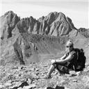
After a pleasant, if slightly boring hike, arrival on the summit presents you with the jewels of the Crestones. After staring at a broad tundra ridge for the last hour or two, the rocky jagged ridge line of the Crestones and Kit Carson - Challenger massif is quite a treat. It would be nice to sit here for a long time, just soaking it in. But it's a long trek back, so I can't stay as long as I would have liked. Plus the wind has picked up on the summit, which is blocked below on the ridge, so it's getting fairly chilly.
Summit Pano Crestones Obstruction, Columbia, Kit Carson & Challenger Fun ridge to Adams
On the way down, the mileage and elevation gain started to catch up to me. Maybe the altitude change from the last few weeks, where I've been stuck in town made a difference. Or maybe the lack of my usual compression socks caused some fatigue! Hmmmm... Either way, the trek back to the trail head was a lengthy affair. At least all the hunters I met on the trail were smiling, so that was nice to see. Smiles are contagious. The mountain bikers also were quite happy, even when one ended up upside down. Most of the Rainbow trail looked to be good biking terrain, just that last section back to the trailhead was pretty loose with giant cobbles. I wouldn't be biking that!
Looking down the ridge, Westcliffe and Pikes in background Cool tree with Horn Peak behind
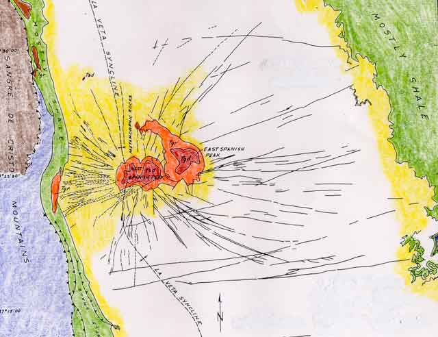
I had wanted to finish the hike with enough time to make it down to West Spanish Peak for sunset on the radial dikes. But that sun set faster than I could drive. So I just found a campsite along the FS road just before the pass. Glad I did, since there is so much private property along the road to Cordova Pass.
Day 2: West Spanish Peak
Trailhead: Cordova Pass
Mileage: 7
Elevation Gain: 2,687'
Partner: Solo
Downside to my campsite - it seemed to be in a wind tunnel, as all night it seemed there was non-stop 50mph gusts rattling and rocking my truck. Even opening the back of my camper shell and slamming it shut. My expected 9 hours of glorious sleep, turned into much shorter stretches punctuated with strong shakes and loud whistles. So instead of waking up refreshed, I felt quite haggard and sleepy. Would I even get to hike today in these winds?
Not sure about the winds, I get into the cab of my truck (still in my pj's) and decide to drive to the trailhead and decide later. The road up to Cordova Pass is still in good shape, only a couple sections of icy snow, but there are dirt tire tracks that cut through it. So I'd still call it open to 2WD. At the trailhead another car arrives and a hiker gets out. She seemed pretty confident about the wind, so maybe she didn't have the night I did. A few minutes later, as I'm packing and eating breakfast, a gust of wind rocks my truck. Ever so glad I got the suspension fixed, otherwise that wind would have made me nauseous!
Probably 10-20 minutes after the other hiker left, I was finally ready to go. The first part of the hike was rather pleasant woodland stroll. Not much elevation gain or loss. Plus a couple really nice views along the way. Wind was quite low as compared to before.
First good view of West Spanish A dike off the west ridge of West Spanish
Once you exit the trees, the trail and the wind makes an abrupt change. The nice woodland trail goes away, and is replaced by a steep and relentless talus and scree ascent. It's slightly better sticking closer to the ridge, as there is some solid rock, but that doesn't last forever. The wind also picks up, as the trees are no longer blocking it.
Halfway up the slope, the other hiker is making her way down. I ask about the wind on the summit, and she says it's brutal and that she only stayed long enough to wait for a lull to take photos and then left. So as I get close to reaching the summit ridge, I put on my puffy and wind shell while I'm still warm.
Giant talus-scree slope ahead Culebra Range peaks An old ski hill Snow approaching the summit Summit once topping out on ridge
Whereas yesterday, the best views presented themselves only on the summit, today I had the views for much of the approach. The bonus was seeing East Spanish Peak and all the dikes that are in the valley. Since I had bundled up, I spent a much longer time on the summit than the previous hiker. I pretty much waited until my hands were frozen to descend.
East Spanish Peak Culebra Range Radial Dikes More Dikes with Blanca group behind Blanca Group
Once I got too cold to remain, I start heading down the ridge, and just stare at the Culebra Range, trying to pick out the various peaks. There are a couple that are "open", so it was good to get some visual beta for a return in the future.
Looking down the ridge to Culebra Range
The hike out to the trailhead went quickly, once I was off that scree-talus heap. And like a bad cliche, a quarter mile from the trailhead I run into not just one unleashed dog, but a whole pack of them. "Oh they're friendly", comes the call from one in the group. Today the snow was unavoidable for the most part, but also not much of an issue either. No post-holing or otherwise.
Being a geoscientist, the drive out of town was fun, if a bit chaotic with lots of turn arounds and stops. My first or second weekend in grad school, I took a trip with the volcanology class to look at the various igneous intrusions in the area. We did a hike up Huerfano Butte and went to the dikes around West Spanish Peaks. I don't remember all that much from the trip, as it was so long ago (15 years), so it was nice to make a return to see it again.
West Spanish with a Dike Devil's Stairstep/Staircase West Spanish with Devil's Stairstep Dike Backside of Devil's Stairstep West Spanish with another long Dike West Spanish with yet another Dike East & West Spanish with a Dike
My GPS Tracks on Google Maps (made from a .GPX file upload):
Those dikes are cool, aren't they? 10/29/2014 6:23pm
As I don't have your background in geology, I did a lot of reading about them once I got home. East SP is fun, too - I found it a little more difficult than West. Nice pics and, as always, great write-up
I agree with Jay. ESP is definitely a worthy peak. I enjoyed it more than WSP. Keep me in mind when you come down south. It's been entirely too long since we have been ”bump humping”.
Otina is back to form! It's SO awesome to see you submitting trip reports again and getting back out there.
I didn't realize the 'ridges' on Colony Baldy were that docile.
Jay - Always love the peaks that have some cool geology thrown in!I'll have to make sure ESP gets hiked in the future then.
Vicki - I guess you do have a bit more time now, since biking used to fill most/all of your free time. I still have a few more Sangre peaks on the list, hopefully we can get out schedules matched up!
Nat - I had hoped a sunny dry week would help CB after you did it. So thanks for that beta! Funny, soon (very soon!) we'll be seeking out the opposite - more snow!
Kiefer - It's good to be back! That ridge was quite tame, but very long. Not a bad reintro.
to see familiar landscapes with different weather/snow conditions. Quite a bit has melted out on CB after a week of sun (duh!). We ran into hunters as well - they were friendly too, haha! Can't decide if West Spanish Peak is best done under gale force winds in October or getting a heat stroke while descending it back in June. Thanks for pointing out the dikes - I saw them from the summit, but totally missed it on the ground. Nice to see you out and about!
I’ve never met you but...What are the chances that two solo women climb West Spanish peak in October on the same day? I was just updating my climbed peaks list and couldn’t remember when I did this. Thanks for posting an excellent report. Does the wind ever stop blowing down in the Sangre’s?
The new bridge is finally in at Macey Creek
and the Rainbow Trail is fine out to the start of the NE Ridge.
There is a cairn at the ridge toe and a fairly well cairned trail to tree line.
There is still an area of blow down about 100–200 yard in, at the beginning of the ridge.
Otherwise it is easy to follow.
Best summit view in the Sangres.
Did this yesterday.
Your pictures are much better than mine, Thanks.
Caution: The information contained in this report may not be accurate and should not be the only resource used in preparation for your climb. Failure to have the necessary experience, physical conditioning, supplies or equipment can result in injury or death. 14ers.com and the author(s) of this report provide no warranties, either express or implied, that the information provided is accurate or reliable. By using the information provided, you agree to indemnify and hold harmless 14ers.com and the report author(s) with respect to any claims and demands against them, including any attorney fees and expenses. Please read the 14ers.com Safety and Disclaimer pages for more information.
Please respect private property: 14ers.com supports the rights of private landowners to determine how and by whom their land will be used. In Colorado, it is your responsibility to determine if land is private and to obtain the appropriate permission before entering the property.


 First view of peak and it's 2 false summits")
 Fluted, Little Horn and Horn Peaks")
 Ridge to first false summit")
 Ridge to 2nd false summit")
 Sangres to the north")
 Ridge to the summit")
 Summit Pano")
 Crestones")
 Obstruction, Columbia, Kit Carson & Challenger")
 Fun ridge to Adams")
 Looking down the ridge, Westcliffe and Pikes in background")
 Cool tree with Horn Peak behind")
 First good view of West Spanish")
 A dike off the west ridge of West Spanish")
 Giant talus-scree slope ahead")
 Culebra Range peaks")
 An old ski hill")
 Snow approaching the summit")
 Summit once topping out on ridge")
 East Spanish Peak")
 Culebra Range")
 Radial Dikes")
 More Dikes with Blanca group behind")
 Blanca Group")
 Looking down the ridge to Culebra Range")
 West Spanish with a Dike")
 Devil's Stairstep/Staircase")
 West Spanish with Devil's Stairstep Dike")
 Backside of Devil's Stairstep")
 West Spanish with another long Dike")
 West Spanish with yet another Dike")
 East & West Spanish with a Dike")