Download Agreement, Release, and Acknowledgement of Risk:
You (the person requesting this file download) fully understand mountain climbing ("Activity") involves risks and dangers of serious bodily injury, including permanent disability, paralysis, and death ("Risks") and you fully accept and assume all such risks and all responsibility for losses, costs, and damages you incur as a result of your participation in this Activity.
You acknowledge that information in the file you have chosen to download may not be accurate and may contain errors. You agree to assume all risks when using this information and agree to release and discharge 14ers.com, 14ers Inc. and the author(s) of such information (collectively, the "Released Parties").
You hereby discharge the Released Parties from all damages, actions, claims and liabilities of any nature, specifically including, but not limited to, damages, actions, claims and liabilities arising from or related to the negligence of the Released Parties. You further agree to indemnify, hold harmless and defend 14ers.com, 14ers Inc. and each of the other Released Parties from and against any loss, damage, liability and expense, including costs and attorney fees, incurred by 14ers.com, 14ers Inc. or any of the other Released Parties as a result of you using information provided on the 14ers.com or 14ers Inc. websites.
You have read this agreement, fully understand its terms and intend it to be a complete and unconditional release of all liability to the greatest extent allowed by law and agree that if any portion of this agreement is held to be invalid the balance, notwithstanding, shall continue in full force and effect.
By clicking "OK" you agree to these terms. If you DO NOT agree, click "Cancel"...
Approach: FS379 about a mile from Gold Camp Road
Length: About 10 miles RT
Vertical: About 2500 feet
Ascent Party: Solo
Other than a few climbs of Pikes Peak and going up the Incline, Centennial Cone and Mount Rosa, I have not spent much time in the mountains near Colorado Springs. I had read several reports on Almagre and decided that looked like it might be a fun little walk. And it was. I underestimated the time it would take me to reach my starting point from my home in Aurora by a factor of 2 but that is par for the course. My intention was to drive to the junction of FS379 and FS379A but that didn't work out so well as you will see.
But, this was a fun little hike to a summit with great views. (Captions below the photos)
About a mile up from the junction of Gold Camp Road and FS379, there is a little stream to jump.
Just after crossing the stream, I came up to this ice flow and decided I didn't want to attempt it.
So, I backed up a little and found this nice pullout and started out my hike from there.
I spent the next hour walking up the road congratulating myself on my prudence until another vehicle drove by me. On my hike out, SEVERAL vehicles were driving beyond the ice flow so I guess I'm a bit of a weenie in the driving department.
Further on the road, there was evidence of what I think might have been a water metering station?
And this sign caught my attention in Frosty Park.
Cause maybe they shoot back?
I continued on the road and started to get an idea of the route I might take as I spotted the road cut on the mountain side.
On FS379 looking at FS379A on the mountain side.
I decided not to follow FS379 all the way to the junction of FS379A but rather cut up on what looked like an old trail. Unfortunately, I did not take a picture of this spot where I left the road, but it was a sharp hairpin left and there was a sign that said "All Vehicles Must Stay on Road". Or something similar.
The route up worked well. There was some evidence of old foot traffic and a couple cairns.
Eventually, I broke out of the trees into an open area.
As shown below, the tracks indicate it was apparent that this bare spot could be accessed more directly from the road.
I headed west (straight ahead) out of the open area following the old tracks.
For a while, it looked like ATV's had been this way
Looking back
But the trail got narrower
And after one switchback, even narrower.
Eventually, this trail linked up with FS379A
Still on the trail, just below the road.
From the road, looking back east.
Mount Rosa, Frosty Park is the horizontal light area at the base of Rosa, and closer still is the open area where I broke out of the trees.
FS379A is a good road. False summit of Almagre in the distance.
A look back at the road. Mount Rosa to the left.
Eventually, you end up at a gate.
I guess signs can't shoot back.
But don't try ramming this gate or you may need a new radiator.
Empty storage shed with Signal Mtn in the distance.
The old Stratton Dam and empty reservoir.
A closer look at the dam.
Not quite enough ice for pond hockey.
From the reservoir, there are remnants of an old road that eventually leads to the summit.
The summit is the round bump in the distance.
The actual summit
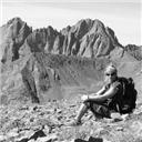
The views from the summit are what makes this a worthwhile hike.
There was a register but it was pretty soggy.
Pikes Peak with the upper portion of the cog railway route visible.
Looking west - not sure what those lakes/reservoirs are??
Signal Mtn to the south.
Mount Rosa and the plains beyond.
Nice view of the Springs.
A short 360 degree vid from the summit.
And, as I don't carry a GPS, this is an approximation of my route.
Thanks for taking the time to read this and be careful out there!
Thumbnails for uploaded photos (click to open slideshow):
Two summers ago I did a ride called "Ring the Peak". The area you traveled was by far the most entertaining for me. Bullets flying over my head, Jeeps getting stuck in mud up to their doors, sharing the road with crashing ATV’s and sucking moto dust. Also the evil webbing of confusing trail. Very easy to get lost back there. Good on you for being smarter than the rest.
I’ve always wanted to get up there sometime...I didn’t realize it was from the same start as I did Rosa from. I realized that when I saw the frosty park sign photos above...If I remember, seems like there were a lot of clay pigeons up in that park too.
A few years back, I did a very similar route, but: you should have followed the ridge south to hit also South Almagre (Signal?) which is, I believe, also a ranked peak. Both are summits that are easy to see from the Colo. Springs area, but often overlooked by climbers. Thanks for posting; that first photo is great.
Another mountain for another day. 12/17/2014 3:22pm
Toes – I didn’t put it in the report, but I heard a lot of small arms fire (mainly rifle, pistol with a few shotgun blasts thrown in) while I was on my way down too. Reminded me of my time in Nam. Normally, I like to take a different route down that involves some bushwhacking but hearing the gunfire made me decide against it.
Derek – Yep – lots of clay pigeons. It’s a pretty area and well worth a visit.
Patrick – My original intention was to catch Signal and Baldy but I was feeling like total crap and just wanted to get home and go to bed so I bailed on those two. But – as Arnie said – "I’ll be back."
The globreal took me up Mt Vigil a few years ago and it was my first time exploring the terrain between Cheyenne Mtn and Pikes. And yes there was a lot of gunfire all day. This 12er looks like a nice one, thanks for posting!
For those who mountain bike......Almagre is a great way to combine biking and hiking, and make those dirt road miles go by quicker. I parked at Gold Camp Road and 379. Mountain biked all the way up to Jay’s Picture #16 and stashed my bike in those trees (could have gotten a little farther, but snow stopped by biking progress). Hiked to Almagre’s summit and back to my bike. FLEW down the road to where Mt. Rosa hike begins. Stashed my bike and hiked Mt. Rosa, then biked back to my car. Bring a lock for your bike to deter all the rednecks that seem to love Frosty Park.
Mike – thanks for the compliments, man. Looking forward to our next adventure!
Brian – Britt does know that area, doesn’t he? I’ll have to take a look @ Vigil.
Vicki – I read your comment about mountain biking that route on another TR and found it fascinating. Maybe I should take up mountain biking – looks like it would be a good way to stay in shape.
Thanks all for the comments and likes. MUCH appreciated!
And I finally got around to reading yours 12/24/2014 3:56am
Haha. Been a little crazy with the holidays and work! Nice job as always, Jay! Merry merry Christmas!!!! I better see you in 2015.
Caution: The information contained in this report may not be accurate and should not be the only resource used in preparation for your climb. Failure to have the necessary experience, physical conditioning, supplies or equipment can result in injury or death. 14ers.com and the author(s) of this report provide no warranties, either express or implied, that the information provided is accurate or reliable. By using the information provided, you agree to indemnify and hold harmless 14ers.com and the report author(s) with respect to any claims and demands against them, including any attorney fees and expenses. Please read the 14ers.com Safety and Disclaimer pages for more information.
Please respect private property: 14ers.com supports the rights of private landowners to determine how and by whom their land will be used. In Colorado, it is your responsibility to determine if land is private and to obtain the appropriate permission before entering the property.


")
")
")
")
")
")
")
")
")
")
")
")
")
")
")
")
")
")
")
")
")
")
")
")
")
")
")
")
")
")
")
")
")