Download Agreement, Release, and Acknowledgement of Risk:
You (the person requesting this file download) fully understand mountain climbing ("Activity") involves risks and dangers of serious bodily injury, including permanent disability, paralysis, and death ("Risks") and you fully accept and assume all such risks and all responsibility for losses, costs, and damages you incur as a result of your participation in this Activity.
You acknowledge that information in the file you have chosen to download may not be accurate and may contain errors. You agree to assume all risks when using this information and agree to release and discharge 14ers.com, 14ers Inc. and the author(s) of such information (collectively, the "Released Parties").
You hereby discharge the Released Parties from all damages, actions, claims and liabilities of any nature, specifically including, but not limited to, damages, actions, claims and liabilities arising from or related to the negligence of the Released Parties. You further agree to indemnify, hold harmless and defend 14ers.com, 14ers Inc. and each of the other Released Parties from and against any loss, damage, liability and expense, including costs and attorney fees, incurred by 14ers.com, 14ers Inc. or any of the other Released Parties as a result of you using information provided on the 14ers.com or 14ers Inc. websites.
You have read this agreement, fully understand its terms and intend it to be a complete and unconditional release of all liability to the greatest extent allowed by law and agree that if any portion of this agreement is held to be invalid the balance, notwithstanding, shall continue in full force and effect.
By clicking "OK" you agree to these terms. If you DO NOT agree, click "Cancel"...
Class 2
Total Mileage - 14 miles
Elevation Gain - 4450'
Trailhead - Scott Gomer/Abyss Lake Trailhead
Bierstadt? Really? Not only do I never write TR's on 14ers, but when I do it's on Bierstadt?
Well, this is because I wanted to post some general information on a lesser used route on one of the more (most?) popular front range 14ers. I didn't notice any reports for this route (although it is listed in Roach's 14er book) so figured some information may be helpful and/or useful.
A few pro's and cons of this route:
PRO's:
1- Winter access. The TH is prior to the Duck Lake closure, so easily accessible in winter.
2- Quiet. Slim chance you'll run into someone until the final summit push.
3- Scenery. Better views than the standard route. (Suppose that is just my opinion.)
CON's:
1- Bigger day. Expect about double the mileage and +1,600' or so compared to standard route.
2- Off trail. (Could be a pro?) Except for first 3 miles, the route is off trail requiring one section of tough bushwhacking.
Trailhead-
It is the Scott Gomer/Abyss Lake Trailhead and is located 5 miles from 285 and Grant along the Guanella Pass road. However, at this moment it is not usable due to heavy road machinery being stored there. I went ahead and parked at the Burning Bear campground a hundred yards away, but once the campground opens for the summer this won't be possible. So hopefully the trailhead will be clear and the road construction completed on the road before too long.
Route-
From the trailhead, follow the Abyss Lake Trail east/northeast for 3 miles. The trail is nice, open and clear (minus snow) as it seems to be popular with day hikers. The trail only gains about 1,000' during these three miles, and does so slowly. Nice warm up for the remainder of the day.
Only a hundred or so yards in, you enter into the Evans Wilderness.
The first three miles of trail is quite mellow, ascending only about 1,000' during those miles.
The trail criss-crosses the creek about 3 times, each crossover was easily identifiable. Pictured is "Bridge 1".
Bridge 2 is a bit more...rustic?
Tons of aspens throughout the first miles...my assumption is that this would make a spectacular fall hike.
Trail following the creek.
South side of Geneva with a good trail.
After these first three miles, you will reach a trail intersection that you should continue straight (following towards Abyss Lake) rather than headed left towards Guanella Pass. Now, being covered in snow I lost the trail in this meadow...but even if this happens to you it seems fine as you'll be leaving the trail shortly anyway. Roach's book and our resident Bierstadt expert Jay521 both note to leave the trail .25 miles or so after the intersection and head left off trail up towards the ridge. Since I lost the trail, I just headed up to the ridge straight from the meadow.
The ridge above treeline is easily visible from down below, so it helped to see the goal location prior to entering the trees. Once in the trees heading up, stick to the right (south) end of the ridge. Not only does the exposure help with the snow, but the entire top of the ridge is covered in large downed trees. (Recent down fall, so likely from the New Years winds a couple years back that caused similar falls in the area.) Even though the sidehilling in some spots was a bit annoying, it was MUCH easier than dealing with the downed trees.
After around 1,000', you'll break treeline and only have a few hundred feet to go to reach the base of the true south ridge.
3 miles in, the first views of Bierstadt's south ridge come into view over an open meadow area. Somewhere in the vicinity of this photo is a trail junction, on which you continue straight. If you lose the trail (as I did) just head for the rise on the right of the photo.
Roach (and Jay521) noted following the trail a .25 or so past the intersection, then ascend north to reach the ridge. Having lost the trail, I blasted straight in and was met with a tough aspen bushwhack.
Thankfully, it cleared every now and then to let in the views. Pictured is Square Top to the north.
I found it easier to get through this section sticking just to the south of the ridge top. Massive blow over/tree fall is all over the top of the ridge (not to mention snow drifts) so avoid if you can.
After 1,000' feet of bushwhacking pain, treeline is met and shortly after the true south ridge.
Logan and Kataka to the south.
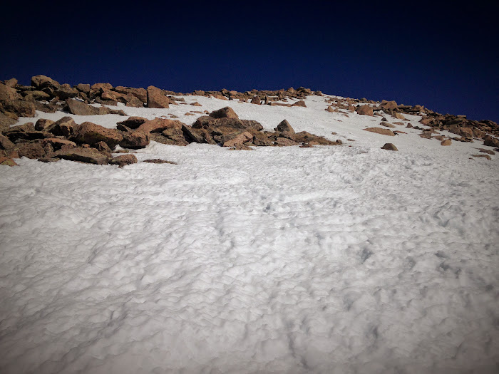
By the time you reach the start of the ridge, you've put in around 2,500' of elevation but still have about 2,000' to go. Taking a left and starting up the ridge, the first bump to go over is only a few hundred feet up and talus covered. Thankfully, there are a number of grassy paths that can minimize the talus hopping. Either way, its still a bit of a leg burner.
From the top of this first bump, the second larger bump leads to the false summit of Bierstadt. (This bump tops out around 13,700'.) Again, lots of talus however I found a number of snow slopes that helped get through much easier. In the summer, you'll probably need to rely on boulder hopping as there weren't any grassy ramps in this section that I could tell.
After reaching the false summit, the remaining route up to the summit can easily be seen. At the saddle between the false and true summit, the route merges with the standard route coming up from Guanella Pass, so you are likely to see some company here. (There was one other with me on the summit coming up from that way.)
Bierstadt's South Ridge begins. The two major "talus bumps" are visible.
Basin leading up to Frozen Lake off to the right of the ridge.
Epaulet and Epaulie in the distance.
The first bump isn't too bad, as much of the large talus can be skipped following intermittent grassy slopes.
Eventually, there becomes no other option than to talus hop on up.
The second "talus bump" is a bit tough / longer, but snow assisted in skipping much of the talus.
Bierstadt's East Ridge. Fun route that can be accessed from the Mount Evans Road (Tour 'd Abyss) or the more sporting Abyss Lake Trail.
At the top of the second bump, the true summit comes into view. The final 2-300' to the summit merges with the standard west route.
Summit of Bierstadt.
A look down the standard route.
Descending back down the ridge.
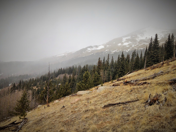
Weather moving in over the south end of Geneva.
This crap again.
Somewhere is a very happy beaver.
I didn't stay long on the summit, as some clouds were moving in. (Thoughts of descending some of the talus on slick rock didn't sound enjoyable.) Going down took almost as long as going up for me which is odd, but the talus made me have to slow down a bit.
In terms of effort, this hike really reminded me of Columbia's SE ridge. A bit less elevation, but a bit harder on the bushwhack evened it out. Definitely tougher than the standard, and would imagine it would be a real bear in deep snow conditions.
Great solo day out, and fun collecting my 4th unique ascent route up this peak.
But I think you give me too much credit. You certainly had more deadfall to contend with than when I did it (20 years ago?). Seeing your TR makes me want to do it again... I think....
Al Gore sure brought the global warming 4/14/2015 2:03pm
Seriously, this is April, where is all the snow?
And this can’t be the real Derek, he would never post a trip report for a peak above treeline...
Caution: The information contained in this report may not be accurate and should not be the only resource used in preparation for your climb. Failure to have the necessary experience, physical conditioning, supplies or equipment can result in injury or death. 14ers.com and the author(s) of this report provide no warranties, either express or implied, that the information provided is accurate or reliable. By using the information provided, you agree to indemnify and hold harmless 14ers.com and the report author(s) with respect to any claims and demands against them, including any attorney fees and expenses. Please read the 14ers.com Safety and Disclaimer pages for more information.
Please respect private property: 14ers.com supports the rights of private landowners to determine how and by whom their land will be used. In Colorado, it is your responsibility to determine if land is private and to obtain the appropriate permission before entering the property.