Download Agreement, Release, and Acknowledgement of Risk:
You (the person requesting this file download) fully understand mountain climbing ("Activity") involves risks and dangers of serious bodily injury, including permanent disability, paralysis, and death ("Risks") and you fully accept and assume all such risks and all responsibility for losses, costs, and damages you incur as a result of your participation in this Activity.
You acknowledge that information in the file you have chosen to download may not be accurate and may contain errors. You agree to assume all risks when using this information and agree to release and discharge 14ers.com, 14ers Inc. and the author(s) of such information (collectively, the "Released Parties").
You hereby discharge the Released Parties from all damages, actions, claims and liabilities of any nature, specifically including, but not limited to, damages, actions, claims and liabilities arising from or related to the negligence of the Released Parties. You further agree to indemnify, hold harmless and defend 14ers.com, 14ers Inc. and each of the other Released Parties from and against any loss, damage, liability and expense, including costs and attorney fees, incurred by 14ers.com, 14ers Inc. or any of the other Released Parties as a result of you using information provided on the 14ers.com or 14ers Inc. websites.
You have read this agreement, fully understand its terms and intend it to be a complete and unconditional release of all liability to the greatest extent allowed by law and agree that if any portion of this agreement is held to be invalid the balance, notwithstanding, shall continue in full force and effect.
By clicking "OK" you agree to these terms. If you DO NOT agree, click "Cancel"...
With the sensory overload of Weminuche, it is hard to come up with another area to go into right after... Except for this little area - the Ice Lakes basin. After climbing Vermilion and Fuller last year as a day trip, I wanted to go back and spend at least a couple of days in the basin. With several bicentennials and other 13ers in the area, a short backpacking trip was in order. I got to the Mineral Campground at dusk on a Friday with the idea to get an early start. Things didn't go according to plan, of course. Barely awake at 6.30 am, I drove to the high switchback in my Subi only to find out that all parking spots had been already taken. I didn't realize quite yet that this area on the weekend is becoming like Grays and Torreys trailhead. Well, nothing else to do but to head back down and to start from the lower trailhead. With all this back and forth (and the line to the restroom), I didn't get started before 8 am.
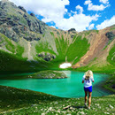
With the late start, I decided to concentrate on easier targets such as US Grant and "V4". I made it to the lower Ice Lake in a couple hours and started looking for the turnoff to the Island lake. I recall being one there last year. I identified the turnoff by a cairn and a short time later got a great first view of the lake, with a couple bright tents in the middle of the island! Some jokesters brought a raft and floated their overnight supplies and tents to the island.
Approaching Island lake
Being already 11 am, weather started to look threatening, so I decided to set up a tent by the lake. It started raining as I ate lunch, so I took a nap for nearly an hour, very relaxing. Around 1 pm the rain stopped, and by 1.15 pm I was hiking towards the saddle between US Grant and "V4". I was hoping for a 3-4 hour window between the storms.
Blue sky over US Grant
I got to the saddle near 13.2k, evaluated the conditions (storms brewing, but still far away), so I proceeded towards US Grant. With fair amount of cairns the trail was easy to follow. Eventually I ran into the Class 4 "wall", and for a minute or two wasn't sure how to proceed and if I were on route. Cairns on the upper ledge were hard to spot from the bottom. Holds were great though, particularly for the feet, and after a few moves I topped out and noticed cairns. Good, I was on the correct ledge.
Straightforward climb to the saddle
Crux wall
Great holds, especially for the feet
Looking down on the crux
Final obstacle before the summit
View of the Island lake from the summit
By 2.45 pm I was on the summit admiring the views (and the incoming clouds). This was also Bicentennial #50 for me, I let it sink in for a minute. But with the incoming weather, there was no time to linger. Descent was pretty straightforward, I took a few variations, and 30 minutes later was back at the saddle.
Storm brewing over the Wilsons
I ended up downclimbing this gully on the descent
Now, do I have time for "V4"? After previewing the peak from "V2" back in June, I already knew it's better done with snow and anticipated it to be loose, but the curiosity was too strong. Sure enough, it was loose, with no cairns. Without the route beta, it took me a little longer than I hoped to find the summit and I tagged several rocky towers in the process, and as I started the descent, it began raining again.
Summit ridge of "V4"
Upper Ice lake from "V4"
Loose descent off "V4"
Dry couloir I was hoping to ski
I dropped down pretty quickly and was back in the tent 40 minutes later. Time to eat more food, rest and wait for the rain to stop. With my goals accomplished, I was hoping to move the camp above the Ice Lake later this evening. Around 6.10 pm the rain finally stopped, and after rolling up the tent, I was hiking ten minutes later. Bonus - trail to the Ice Lakes from the Island lake was downhill, which was much appreciated. I ran into a few tents by the Ice lake, but knowing my propensity to linger in the mornings, ultimately decided to head higher and to set up the camp near 12.5k. By 7pm I was arriving at my new camp site, finding a great flat area close to several water sources.
After the rain - neighbors are still there
V4 reflection in the Ice lake
Day 2 - Pilot Knob and Golden Horn
Ascent: ~1,800 ft, descent: ~4,400 ft, mileage: ~8 miles
Flash-Crack-Booom! I jump in my sleeping bag, trying to assess the situation. Flash-Boom! I am at 12.5k, above the tree line, with a bunch of electronics, stove fuel and metal objects in my tent during a lightning storm. Crap!!! Time is 22.20 pm, so it didn't rain for only 6 hours. Flash-Boom! I count the seconds between the flash and the sound, and at least it sounds like the storm is not in the absolute vicinity. In the pouring rain with some sleet, I push out the fuel, poles and Jetboil away from the tent. In about an hour the storm subsides and I go back to sleep.
Ahhhhwooooo! I jump out of my sleeping bag again. What now? A pack of coyotes, pretty close. Much closer than a lone coyote in the Trinity Basin a week ago. Time - 2.30 am. Nothing to throw at them if they come close. No rocks, and my stove, poles and fuel are out of the tent. Crap! I get out of the tent to bring the gear back. The howling stops. Are they watching me? Are they getting close? Man, it's hard to get any sleep here at 12.5k! Eventually, sleepiness prevails and I fell back asleep.
Up by 6 am, feeling a little groggy. Alpenglow on Pilot Knob is rather unusual sight to behold though.
Alpenglow that lures me out of the tent
A few minutes later
Campite view
Moving by 7 am. Goal - the notorious Pilot Knob! Being solo, I decided to go as far as I am comfortable, and turn around if I don't like the summit ridge traverse. The approach is short and soon I am looking for some anchor rocks on a loose slope. Quite doable, and by 8 am I am topping out at the 13.4k saddle, spotting my first cairn.
Only 300 feet to go!
Traverse to the north side goes smoothly and I find the obvious C3-4 rocky gully. I am being careful not to dislodge any rocks, but the climbing is pretty good.
Heading up the gully
Now to the good/exposed/scary part! I stash the poles and carefully and slowly make my way up the exposed ridge line.
I climb one of the towers...and don't see the good way past it. Somehow I decide to downclimb it on the north side. Realizing a route finding error, I climb back up. After taking a better look at the backside of the tower, I notice a straightforward C3 downclimb - duh. This brings me to the 2nd tower and the exposed traverse/downclimb. My 5.10 Guide tennies love this stuff and by 9 am I am relaxing and taking in the summit views. Great register too.
Vermilion and the summit ridge
Heading back
Loose traverse on the north side to gain the ridge with Golden Horn
Weather is still looking pretty good, so I decide to do the traverse to Golden Horn. The north side of Pilot Knob is my least favorite, being loose and unstable. Once I gain the ridge, I stay on it and arrive to the saddle between GH and Vermilion without issues. By about 11 am I reach the 1st summit. Climbing is good and rock on the upper mountain is solid, so I decide to tag the 2nd summit just in case.
Ridge to Golden Horn and its two summits
Looking back at Pilot Knob
Vermilion
Ice Lake and V4
V3, US Grant & V4
Pilot Knob
I was hoping to head up Vermilion as well, but the incoming weather was ruling out that possibility. So down to the camp I went.
Another lake and a mine on the way back to camp
Noticing more clouds and afraid of any potential lightning storms, I quickly pack up the camp and leave. I ran into quite a few people on the way down, fully realizing how popular this area is with day hikers, arriving at my car around 4pm.
My GPS Tracks on Google Maps (made from a .GPX file upload):
... is fantastic. Reading your report makes me itch to get back up there and follow in (some of) your footsteps. Pilot Knob will have to wait until I ramp up my skill set, I think....
Camping on the Island lake Island is now on my bucket list! This is an awesome post. Last year was my first climbing trip. We camped at the mineral campground and hiked to Ice Lakes. This year, I am climbing my first 14er and 13er (Handies and Whitecross), then coming back down this way to try for a 13er around Ice Lakes. I do love the view you have from US Grant !!!! I have ruled out Pilot Knob (too scary for me!) but maybe US Grant, Vermillion, V4, or Golden Horn!
Caution: The information contained in this report may not be accurate and should not be the only resource used in preparation for your climb. Failure to have the necessary experience, physical conditioning, supplies or equipment can result in injury or death. 14ers.com and the author(s) of this report provide no warranties, either express or implied, that the information provided is accurate or reliable. By using the information provided, you agree to indemnify and hold harmless 14ers.com and the report author(s) with respect to any claims and demands against them, including any attorney fees and expenses. Please read the 14ers.com Safety and Disclaimer pages for more information.
Please respect private property: 14ers.com supports the rights of private landowners to determine how and by whom their land will be used. In Colorado, it is your responsibility to determine if land is private and to obtain the appropriate permission before entering the property.