Download Agreement, Release, and Acknowledgement of Risk:
You (the person requesting this file download) fully understand mountain climbing ("Activity") involves risks and dangers of serious bodily injury, including permanent disability, paralysis, and death ("Risks") and you fully accept and assume all such risks and all responsibility for losses, costs, and damages you incur as a result of your participation in this Activity.
You acknowledge that information in the file you have chosen to download may not be accurate and may contain errors. You agree to assume all risks when using this information and agree to release and discharge 14ers.com, 14ers Inc. and the author(s) of such information (collectively, the "Released Parties").
You hereby discharge the Released Parties from all damages, actions, claims and liabilities of any nature, specifically including, but not limited to, damages, actions, claims and liabilities arising from or related to the negligence of the Released Parties. You further agree to indemnify, hold harmless and defend 14ers.com, 14ers Inc. and each of the other Released Parties from and against any loss, damage, liability and expense, including costs and attorney fees, incurred by 14ers.com, 14ers Inc. or any of the other Released Parties as a result of you using information provided on the 14ers.com or 14ers Inc. websites.
You have read this agreement, fully understand its terms and intend it to be a complete and unconditional release of all liability to the greatest extent allowed by law and agree that if any portion of this agreement is held to be invalid the balance, notwithstanding, shall continue in full force and effect.
By clicking "OK" you agree to these terms. If you DO NOT agree, click "Cancel"...
After a crazy year 2015 during which I got very sick during winter, lost my job and U.S. visa during summer, I had to leave Colorado & decided to put all my stuff into storage and take a few months break far away from this crazy life. After spending 2 months in the Middle East, December in Sri Lanka, January in a beach hut in Goa, India I ended up in Nepal early February. And guess what, it's a good country for trekking! Ok, everybody knows that....
February 27-March 07, 2016 General weather: Clear mornings, cloudy afternoon with occasional snow at altitude Stats: ~99 mi/ Ascent: 29,850 ft vert gross/ Highest point: 18,450'
All related data can be found HERE Route: Lukla to EBC to Gokyo Lake via Cho La pass
Arriving in Kathmandu is quite an experience, it's an organized chaos with cars and bikes honking, dogs barking all the time in the dust of the afternoon and night. After living a month in India already, it was not that much of a difference except that people have a nasty habit of clearing their throat and spiting continuously in the streets.
I dropped my bags straight away in my hostel and went for a walk into crazy Thamel. I popped into one of the many trekking agencies to see whether they could organize a trek to Everest BC for me. I decided to get a guide for the trek, not only it adds value - you can talk with the guide, he can take pictures of you during the journey and he's usually very knowledgeable about the path (even though there is a clearly marked trail all over) and spots to stop by. It would also help me understand how it works if I really want to come back later. My trek was planned to start 4 days later and I spent these extra days in Thamel gathering my equipment - I had nothing with me - and bargaining the best prices. Nepalese are not very lucky these days; after the spring 2015 earthquake, they now have to suffer the Indian fuel blockade which give Kathmandu only a few hours of electricity during thed day. Due to political reasons India has stopped providing Nepal not only with fuel (huge lanes at petrol stations!) but also medicines and earthquake relief material...
To save money and because I didn't really need one, I opted out a porter and I would meet my guide in Lukla which would save me extra bucks not to have to pay for his ticket to Lukla (mine was 360$ KTM-Lukla). I packed my bag early morning and headed up to Kathmandu domestic airport to fly to Lukla. I arrived at 5.15am for a flight at 6.15am and the airport door was closed with already lots of people gathered in front of the door trying to push each other to be the first one in lane. Well there actually isn't any lane, it's the law of the jungle, the strongest push the weakest to get first in lane....
Flight finally departed at 7am when the fog dissipated and it was a pleasant flight, not as scary as many people say - especially due to the good weather. I met my guide Pasang (which means he's born on Friday, plenty of Pasang in Nepal!) in Lukla arrival hall, went for a tea and for a quick chat before starting our journey.
The first few days to Namche Bazaar are a nice walk through villages, it's usually quite flat except the last hour leading up to Namche where the path is really steep and you think it's never gonna stop. Namche itself is built on the mountain and it's just about stairs & stairs in this village like anywhere in the mountain regions of Nepal. You want to get a coffee, you climb up 100 stairs, you want to pee you climb down 20 stairs. We usually spend an extra day of acclimatization in Namche and it's a good opportunity to walk around and get a first view of Everest by reaching the hotel Everest view. It's a good view point and is easily accessible from Namche. We took the opportunity to visit Khumjung few miles away where Sir Edmond Hillary built a school. There is still a memorial located in the playground.
Double suspension bridge leading up to Namche Bazaar. Not sure the lower one is still in service.
View of Namche
First view of Everest with its small cloud and Ama Dablam on the right
Sir Edmund Hillary memorial in Khumjung
Kongde Ri peak overlooking Namche Bazaar
We usually started walking around 7.30am due to the bad weather progressing after lunch time. Even though it was snowy at night, mornings are almost always dry, clear and chilly at this time of the year. You meet a lot of donkeys & yaks carrying fuel, food or whatever on the way up and if at the beginning you are careful about where you walk, you quickly forget that you are spending your day walking in yak poo!
We left Namche that morning to reach Tengboche (12,700') then Dingboche (14,470') the day after.
On our way from Namche to Tengboche
Yaks race
Tengboche monastery. The monastery is the largest gompa in the Khumbu region, it was destroyed by an earthquake in 1934 and was rebuilt. It was destroyed for a second time by a fire in 1989 and then rebuilt one more time with the help of volunteers.
Trail leading from Tengboche to Dingboche
Ama Dablam starting to reveal itself
Arriving in Dingboche
Sherpa stew! This is some good stuff when you're cold and hungry.
Overlooking Dingboche
Tobuche peak (20,075') on our way to Lobuche (16,110')
I didn't meet many people on the way up and down which was great. I talked with few people at night in lodges and they were all telling me that coming early in the season or even in winter is fantastic because you just beat the crowd. It's obviously a bit colder than in April but you don't have all these big groups that usually start to come from mid March.
Scott Fisher memorial at the top of Dugla pass before reaching Lobuche. I was just reading The Climb in Namche but didn't know I would find his memorial so easily. It's one of the biggest memorial amongst the dozens of memorials spread in the area.
"Om mani padme hum" written on stones welcome us to Lobuche
Dry/frozen yak crap is used as fuel for lodges' stoves, it's burning pretty well and keep you warm during the cold nights!!
The idea was to stay in Lobuche an extra night but I was feeling good and was acclimitized quite well so we decided to push for Gorak Shep at 16,865'. We would drop our bags in our lodge before reaching Everest Base Camp 1 hour or so away. We would then spend the rest of the day chilling out before attempting Kala Pathar the next morning. Then we would walk back down towards Zhongla to cross Cho La pass the day after.
Leaving Lobuche early morning. Boulders get bigger and bigger!
Looking back south towards Lobuche
Here we come, bordering the Khumbu glacier
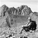
EBC sign! Khumbutse (21,770') in the background and Changtse (Lhola)(24,750'), Everest is "behind" Lhola and cannot been seen from EBC
Sunrise on Everest (29,030') from Kala Pathar (18,520') with Nuptse (25,790') on the right
We were told that conditions on Cho La pass would be very icy and we stopped by a lodge to get at least some spikes for the sake of peace of mind.
It happears that it snowed 2 days before and a thin layer of snow was now covering the ice. We didn't know if it was a good thing or not.
Ultimately the tricky part was very short and we had less problems than expected to cross the pass.
Back in Zhongla, view from the lodge with Ama Dablam in the background
Towards Cho La pass early morning
Looking back at Ama Dablam on the way up Cho La pass
Few icy sections where spikes were useful. Always stay on the left to avoid any problem on this pass!
Summit of Cho La pass with view on the West side of the pass
A well deserved rest in Dragnag, absolute stunning location!
After a nice and long break in Dragnag, we headed towards Gokyo, its lakes and its mountain Gokyo Ri.
As soon as you leave Dragnag, you have a constant and imposant view on Cho Oyu. To reach Gokyo a short hike across the Ngozumba glacier is necessary. It doesn't take long but you walk through a lunar landscape. I was told that the lakes were frozen at this time of the year so I was a bit disappointed after having viewed online the spectacular colours of the lakes later in the season. That's one of the disadvantage of trekking end of February-early March however I'm not sure they will be defrost before quite a while.
Cho Oyu (26,906') from the rocky Ngozumba glacier
Everest from Gokyo Ri
Chilling out on top of Gokyo Ri overlooking the 3rd and 2nd Gokyo frozen lake
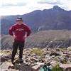
Pasang Temba Sherpa and I on top of Gokyo Ri with Cho Oyu in the background
We then left Gokyo and walked down straight to Namche in 1 long day. We were supposed to stop before that but all lodges were closed, all inhabitants were at the Saturday market in Namche to get supply for the week. Back to the lodge in Namche I met with a man and a woman who were supposedly with the same guide but wouldn't communicate to each other or barely. They were going up so that was their 2nd day only. The first thing the guy told me was: "I hope your pizza is better than mine!" While the woman was complaining she ordered dinner at 7pm and not now (it was 6.47pm at my watch)!.
I thought they would have ruined my trip if they were with me...
Instead I had a blast on this trip with a fantastic guide - we laughed, joked, sang during the entire trip - in the middle of one of the most beautiful place in the planet without caring for anything else around! It's somehow what people living there are doing on a daily basis. I was relieved that Internet connection wouldn't work in most places (it still works in EBC!) and was often dreaming about ascending a 8000m peak. I was there, I was ready...or not. May be one day.
After return to Kathmandu, I rested only few days before going to Pokhara to undertake the Annapurna Base camp trek via Poon Hill without guide this time. It is so addictive that I'm still currently in Nepal! But that's another story...
My GPS Tracks on Google Maps (made from a .GPX file upload):
Brings back so many memories of my similar trip this time last year. Hey, and that dog in your picture near LoBouche.......I swear the same dog followed me for 2-3 days around LoBouche, probably because I gave him all my turkey jerkey. I named him Cholla. He gets around ! I could easily retire and live in the villages of Nepal. Kathmandu, not so much. I was overwhelmed in Thamel. Some people like it, I just find it chaotic.
Great narrative and lovely photos. As a bucket list item I hope to check off sooner than later, reading reports like these are the next best thing until I can get there myself. I hope you will post your next adventure!
Very Nice Trip Report! Great photographs too. Looks like an amazing journey over in Nepal. Love the shots of the Khumbu Glacier and Big Peaks! Thanks for putting this together. Fantastic work with doing so well at high altitude. Truly inspiring and impressive feat. Grand, remarkable accomplishment :!:
I just re-read your report and looked at the photos again. One of your comments really struck me......"I had a blast on this trip with a fantastic guide - we laughed, joked, sang during the entire trip - in the middle of one of the most beautiful place in the planet without caring for anything else around! It's somehow what people living there are doing on a daily basis."
I couldn't agree more. I had a similar experience in March-April last year on a very similar trip. Sherpa are the most genuine, happy, caring, and carefree people I've ever met. Most nights, I would sit by the warm stove in the teahouses with my guides and porters. We sang, we danced, we laughed, we shared eachother's culture. They listen, they are humble. They are free spirited. They have very little, but are happier than those who have a lot. I returned to the USA wanting to live my life in a similar manner. I would go back without hesitation.
Your comments and desire to enjoy life and take advantage of being out of work is incredibly inspiring not to mention the incredible pictures. Images #31 and #32 made my jaw dropp. This is one of the best reports I have read in a while. Well done man.
all the comments on here. Hope it provided some of you an insight on what it looks like to be there.
As a hiker/trekker and mountain lover, I spent the most awesome 16 months of my life in Colorado and I badly miss it so don't take it for granted and enjoy every bit of it regardless of anything else. It is a privilege to live near the mountains.
Well done report, Steph.... next up Missouri Mt.? :wink:
Looks like you had such an amazing time!
I miss you dearly but know that I will see you again before too many moon cycles come to pass...
Caution: The information contained in this report may not be accurate and should not be the only resource used in preparation for your climb. Failure to have the necessary experience, physical conditioning, supplies or equipment can result in injury or death. 14ers.com and the author(s) of this report provide no warranties, either express or implied, that the information provided is accurate or reliable. By using the information provided, you agree to indemnify and hold harmless 14ers.com and the report author(s) with respect to any claims and demands against them, including any attorney fees and expenses. Please read the 14ers.com Safety and Disclaimer pages for more information.
Please respect private property: 14ers.com supports the rights of private landowners to determine how and by whom their land will be used. In Colorado, it is your responsibility to determine if land is private and to obtain the appropriate permission before entering the property.


")
")
")
")
")
")
")
")
")
")
")
")
")
")
")
")
")
")
")
")
")
")
")
")
")
")
")
")
")
")
")
")
")
")
")
")
")
")
")
")