Download Agreement, Release, and Acknowledgement of Risk:
You (the person requesting this file download) fully understand mountain climbing ("Activity") involves risks and dangers of serious bodily injury, including permanent disability, paralysis, and death ("Risks") and you fully accept and assume all such risks and all responsibility for losses, costs, and damages you incur as a result of your participation in this Activity.
You acknowledge that information in the file you have chosen to download may not be accurate and may contain errors. You agree to assume all risks when using this information and agree to release and discharge 14ers.com, 14ers Inc. and the author(s) of such information (collectively, the "Released Parties").
You hereby discharge the Released Parties from all damages, actions, claims and liabilities of any nature, specifically including, but not limited to, damages, actions, claims and liabilities arising from or related to the negligence of the Released Parties. You further agree to indemnify, hold harmless and defend 14ers.com, 14ers Inc. and each of the other Released Parties from and against any loss, damage, liability and expense, including costs and attorney fees, incurred by 14ers.com, 14ers Inc. or any of the other Released Parties as a result of you using information provided on the 14ers.com or 14ers Inc. websites.
You have read this agreement, fully understand its terms and intend it to be a complete and unconditional release of all liability to the greatest extent allowed by law and agree that if any portion of this agreement is held to be invalid the balance, notwithstanding, shall continue in full force and effect.
By clicking "OK" you agree to these terms. If you DO NOT agree, click "Cancel"...
After finishing the 14ers, I wasn't sure if I'd ever complete the centennials, and one of the big reasons was that the choss-pile known as Thunder Pyramid scared me. Once I got more committed to the centennials list it still made me nervous, so I resolved to climb it while it was covered in snow, which was what I did to make Little Bear safer.
After a few years of trying to get scheduling and conditions aligned with my friend Brian, this Memorial Day finally brought everything together. The west face was covered in enough snow to make it a complete snow climb, things were stable, and we were ready to go.
The route we took worked out perfectly in that we barely even touched any rocks, and saw not a single one move. We traded the uncertainty of loose rocks and exposure for the known quantity of extremely steep snow on nearly a direct summit finish.
A look at Thunder showing our route in red and the place where the standard route branches off in green
We got to Maroon Lake around 4:40 and were hiking by 4:50 or so, seeing a few headlamps high up on Maroon Peak just as we started. We made quick time to Crater Lake, and shortly thereafter had a very brief snow squall move through, despite the otherwise clear skies.
Looking up towards the Bells as the brief snow squall develops overhead
The trail was mostly snow-covered past crater lake, so we got off track a few times and experienced the ceremonial first posthole of the year, but managed to stay more or less on route until about 10,700 feet at the base of the access gullies for Len Shoemaker Basin and Thunder's West Face lying beyond. Since it would be all snow from here on we put on crampons and started up.
Previous reports mentioned that the snow on this face tended to be hard, and that was true for us as well. We'd actually gotten a later start than originally planned after talking to some people who had been up recently who said it would be a good idea.
The only snow-free portion after putting on crampons was the ledge that you use to traverse over to the white gully just above Len Shoemaker Basin. Other than that it was totally snow.
Len Shoemaker Basin as seen from the last dry ground we would touch until the step onto the summit
We climbed up the snow, noting that there was a large wet-slide path in the middle of the gully, but the debris of it actually made for better climbing because it was easier to step on.
Partway up the White Gully, with our route in red, and the standard route indicated in green
As we got to the point where the standard route cuts off to the right to meet the ridge, we confirmed what appeared to be true from below: there was a path of snow that led almost directly to the summit.
We decided to take this up, and as we got within the last 400 feet or so of the summit the slope angle got dramatically steeper and the snow got harder, so Brian had to be very meticulous kicking steps ahead of me and we slowed down quite a lot. I don't know what the slope angle was, but it was steeper than any snow I've climbed before, including the hourglass on Little Bear.
Brian's picture of one of the steeper sections, though not the very steepest
The reward was that it dropped us off within just a few feet of the summit, and the ridge had enough snow that we only had one or two steps on rock. We were very careful to stick as close to the rocks as possible though since there were lots of cornices and we didn't want them to collapse.
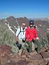
I took this from where we topped out on the ridge, and that's the summit there behind Brian
Looking towards Lightning
We waited on the summit for close to two hours for the snow to soften up to make the descent easier. The sun had hit the last portions of the west face just after we summited, so we had to wait a bit. The weather held out nicely; though storms developed around Sopris and also around Castle, we stayed nice and sunny.
Relaxing on the summit waiting for the snow to soften
As we descended, the steep snow near the top seemed even steeper and I had to keep dark thoughts of what would happen if I slipped at bay by focusing on the pure mechanics of moving down a step, moving the axe, and repeating the process. I would have quite liked some sort of protection on this section and it would have made it much more comfortable, rather than looking down to see where the next step was and seeing the valley 3,000 feet below between your feet every time you look down to find the next step.
Carefully descending some of the steep sections
The first 400' of descent on the steepest part took perhaps an hour, but after that there was a short section of relatively quick climbing while facing in, then a short section of climbing facing out, and then finally the glissade could start, which meant that the second ~2500' of descent took about the same amount of time as first 400 feet. The plan of waiting for snow to soften up was definitely a good one.
From there it was just a matter of trying to avoid postholing and then dealing with the crowds past Crater Lake. Though we witnessed a loud and seemingly large ice fall that perhaps had some water mixed in pouring down some of the waterfall chutes on North Maroon's face.
We looked up when we thought we heard thunder, but discovered this large snow slide cascading down the waterfalls on the face
We got back to the car a bit before 4, feeling sore but glad to have one of the scariest centennials finished safely in good conditions.
I'll agree with other TR writers that snow-cover is the best way to do Thunder, but the route that we took will probably not generally be possible due to snow coverage. Even when it is possible, it's a very steep snow climb and an even tougher descent.
I also think it would have been very difficult to do the standard route on the day we climbed just because of the cornices and snowcover along the ridge making it a bit treacherous to traverse from where the standard route hits the ridge up to the summit.
Thumbnails for uploaded photos (click to open slideshow):
This is really helpful. Still debating between going 6/11 or 6/25. Your comment about the cornices makes me think 6/25 might make more sense given the angle of your finish looks a bit spicy.
Regarding your first pic, with the green and red...I had never seen a pic from that angle before. Brings back a lot of memories, answers a few questions, and should be required viewing for anyone going after that peak. When up there, the most obvious landmark is that gully to the obvious saddle to the climber's left of the red line...should really help orient climbers. Thanks and congrats!
Thanks for sharing, great current beta and pics. I'm going to give this one a try on the 11th.
Caution: The information contained in this report may not be accurate and should not be the only resource used in preparation for your climb. Failure to have the necessary experience, physical conditioning, supplies or equipment can result in injury or death. 14ers.com and the author(s) of this report provide no warranties, either express or implied, that the information provided is accurate or reliable. By using the information provided, you agree to indemnify and hold harmless 14ers.com and the report author(s) with respect to any claims and demands against them, including any attorney fees and expenses. Please read the 14ers.com Safety and Disclaimer pages for more information.
Please respect private property: 14ers.com supports the rights of private landowners to determine how and by whom their land will be used. In Colorado, it is your responsibility to determine if land is private and to obtain the appropriate permission before entering the property.


 Sunrise over Crater Lake")
 Looking up towards the Bells as the brief snow squall develops overhead")
 Closer shot of South Maroon, including the Bell Cord Couloir")
 A look at Thunder showing our route in red and the place where the standard route branches off in green")
 A look towards the Bells from Len Shoemaker Basin")
 Looking up towards the access gully for the White Gully. We traversed the ledges to the left of the snowfield")
 Len Shoemaker Basin as seen from the last dry ground we would touch until the step onto the summit")
 Looking towards Snowmass and Capitol from partway up the White Gully")
 Brian's picture of one of the steeper sections, though not the very steepest")
 I took this from where we topped out on the ridge, and that's the summit there behind Brian")
 Relaxing on the summit waiting for the snow to soften")
 Pyramid, as seen from the summit")
 Looking towards Lightning")
 Another shot of the bells")
 Storms were present a few drainages over, but never came anywhere near us")
 Carefully descending some of the steep sections")
 Partway up the White Gully, with our route in red, and the standard route indicated in green")
 We looked up when we thought we heard thunder, but discovered this large snow slide cascading down the waterfalls on the face")
 Snowmass, as seen from the summit")
 Capitol, as seen from the summit")