| Peak(s): |
Sunlight Peak - 14,061 feet Mt. Eolus - 14,087 feet Windom Peak - 14,089 feet North Eolus - 14,042 feet |
| Date Posted: | 08/12/2016 |
| Modified: | 08/18/2016 |
| Date Climbed: | 08/10/2016 |
| Author: | DanGran |
| Peak(s): |
Sunlight Peak - 14,061 feet Mt. Eolus - 14,087 feet Windom Peak - 14,089 feet North Eolus - 14,042 feet |
| Date Posted: | 08/12/2016 |
| Modified: | 08/18/2016 |
| Date Climbed: | 08/10/2016 |
| Author: | DanGran |
| Climbing in and around Chicago Basin |
|---|
   Introduction: This report tells the tale of a trip I've looked forward to for much of the summer, a backpacking adventure up to Chicago Basin to climb the nearby 14ers and enjoy the spectacular alpine scenery. I want to give a huge shout-out to my friend John! He agreed to go on this trip with me having only already climbed one 14er. Nonetheless, he persevered, making it up every attempted mountain and literally giving me a run for my money as we jogged down Needle Creek Trail with 40 pounds of weight on our backs. John, you show me better than anyone else: "when the going gets tough, the tough get going." You are the tough! Anyway, I hope that I'm able to provoke in anyone reading this report the desire to trek up the basin themselves. I swear it's worth it! Day 1: From Purgatory to Paradise Distance: 18.9 mi. w/ 45 lbs. packs (+2.5 mi. recon w/o packs) Elev. Gain: 4,100 ft.  John and I drove out of Montrose at about 5:45 am with the goal of beginning our day's trek warmed by the light of the sun. We drove through Ridgeway and saw some cool looking early morning fog. Next we headed into Ouray and over the scenic Red Mountain Pass, skirting past Silverton, driving another 45 minutes before reaching Purgatory Flats Trailhead, just north of Durango.  As we set off on our adventure (at around 7:45 am), the day was bright and we were both pretty excited. We began to talk lightheartedly about the scenery we passed and our upcoming climbing plans. I was eager to be in nature again and the weight of my pack seemed... well... not too heavy. John and I quickly made our way down the well-maintained trail. A couple of miles into the hike from the parking lot, raspberry bushes dot the edges of the trail. We gobbled up this sweet surprise with enthusiasm. Mmmmm, breakfast!   The trail remained pleasant and easy to follow as it wound through the woods, chasing after a creek. John and I gained a few hundred feet of elevation then found a nice overlook at which to rest. We talked briefly with a couple from Arkansas in search of elk (I mentioned that the elk may be up slightly higher...) and a group of college-aged guys with fly fishing rods before we continued onward down the trail. Eventually, the path sloped down and we approached the Animas River. At about 10:00 am, John and I heard the sounds of an approaching train. Although we could neither see the locomotive nor the river, a white cloud of steam and soot billowed above the trees across the river valley. Soon, the train passed onward as quickly as it'd come and we reached the first of many river crossings along the trail. A little while after the bridge, we crossed the railroad tracks that our trail would follow all the way to Needle Creek.   It was never really clear when Purgatory Flats Trail turned into the Animas River Trail. Maybe near the Cascade Site right next to the first bridge crossing? I guess that it's not that important...   The Animas River Trail from the Cascade Site is pretty dang flat. Some of the time it was possible to make out the train tracks on the other side of the Animas River, other times the trail meandered deeper into the forest and away from the water. A train came by about once an hour, but John and I were always too far from the tracks to get a good view. That's alright! The trail still provided ample sightings of all types of vegetation as it led us deeper and deeper into the woods. I'm not gonna lie... this section of the trip got pretty tough for me. I walked and walked, yet it seemed like I was making no progress at all towards Chicago Basin, let alone Needle Creek Trailhead. I kept glancing at my watch, hoping the time would pass more quickly. Alas, minutes crept by as I forced myself to take one step after another. The 45 pound pack was digging into my shoulders and back, causing extreme discomfort. No matter how I adjusted it, the pack seemed to get heavier and heavier.   In hindsight, I hadn't been drinking nearly enough water throughout the day, which probably contributed to my fatigue. No matter the cause, I wasn't feeling any amount of joy from the trek anymore and, from the looks of it, neither was John. But we kept going... and then finally at about 1:15 pm we saw the sign we'd been waiting for... Needle Creek Trailhead! We paused to eat a quick lunch, trail mix and peanut butter in a tortilla, then proceeded up this new trail with a renewed sense of adventure! We saw a man who was coming down from Chicago Basin. He told us we had a ways to go. Eh, whatever. We were ready! But then... it started to rain... hard. Even so, I was starting to really enjoy myself again. The cool rain felt great and the slight incline of this new trail took my mind off of the pain in my shoulders and back.  John, however, didn't seem to be feeling as enthused at being soaked and gaining 3,000 feet in elevation (I wonder why???). Nonetheless, he continued to push upwards and onwards and the sun eventually returned from behind a dark thundercloud, chasing the rain away. We hiked the remaining few miles, passing a couple of groups in the process (including a guy with three llamas!!). Finally, the trees began to thin and we could see the basin up ahead. (The pictures below were taken a couple of hours later on our recon. trip up the basin and the following morning at sunrise.)  We proceeded to set up camp and prepare dinner, a freeze dried pack of black beans and rice with extra chicken and cheese. Plus hot chocolate of course... Mmmmmm delicious! I think our kitchen was probably the greatest EVER, as you can see from the picture below.  After our meal, we ambled up the trail in sandals and eating trail mix. Our goal: to scope out Chicago Basin. There were probably about 15 or so other tents scattered throughout the basin another mile and a half up the trail. Our own campsite was apparently pretty low in the basin... but that was alright! After surveying the area, John and I returned to our camp, set up our bear bags, and hunkered down for the night. We both agreed that the day had been one filled with success. Although we suffered all the way from Purgatory, we eventually reached Paradise, a beautiful land of mountains and tents. Day 2: Sunlight and Windom Distance: 13 mi. rt. Elev. Gain: 3,500 ft. I awoke slightly after 5:00 am, not only to the sound of the alarm I had set the night before, but also to a chilly morning of only 40 degrees Fahrenheit! Somehow I still managed to force myself outside to grab the food from the bear bags and set up the stove. After boiling some water for oatmeal and hot chocolate, I started to warm up a bit. In my opinion, warm meals are incredible on trips like this! They always manage to pick me up so much more than a trail mix wrap or couple of granola bars. Anyways, upon finishing breakfast and preparing our day packs, John and I started up Chicago Basin at about 6:15 am. The picture of Chicago Basin at sunrise far above was taken at this time. Just before the Twin Lakes Trailhead, we passed by a group of three also heading up to climb a different mountain: Eolus.   The hike up to Twin Lakes is fairly steep, but there's still a well-maintained trail. As we increased in elevation, following switchbacks up the far side of Chicago Basin, we crossed over a few mountain streams coming down from the lakes above. The entire basin began to spread out beneath us. Upon reaching Twin Lakes Basin, we saw many new mountains, once hidden from view while down below (picture above). As we rested upon a rock near the lakes, we saw a mountain goat coming down the trail from above us (our first encounter of many). It cautiously crept by our rock as we snapped a couple of pictures. Cool animals, the goats!   At this point, I realized that I'd left my sunscreen back at camp. Dang. Not good at all, especially when you burn really easily. I willed the sun to stay behind some clouds as we headed up past Twin Lakes into the basin beneath Sunlight and Windom. The views remained spectacular as both Chicago and Twin Lakes Basin spread out beneath us.  We took a short water break next to one of the enormous cairns on the trail and the sun rose higher in the sky, overcoming the low clouds. I attempted to tie my bandanna around my neck and ears to prevent a massive sunburn from enveloping my entire body. John and I prepared to cross the basin and begin the scramble up Sunlight, but two hikers suddenly came up behind us. They were from the group of three we had passed earlier. One was probably in his forties, the other about 20; I assume they were father and son. The man said his wife had wanted to climb Eolus, but then decided she wasn't up for the task. The two of them decided to try to catch up with us since we had brought along the directions up the mountains and they didn't quite know which mountains were which. Sadly, we never learned either the father's or the son's name, so I will just call them Jim and Junior.   As they began talking with us, Jim pulled out some sunscreen, which he willingly offered to John and me as well, saving us (but mostly me) from what would have been agony later. We discussed the route up Sunlight and ate a bit of trail mix. Then the four of us crossed the basin, walking over a bit of hard packed snow as we approached the gully beneath Sunlight. The climb began! From below, the gully separating Sunlight and Sunlight Spire looked steep and loose. However, following the cairns, I found the climb fairly solid. Rocks and dirt, while not always grounded, gave me decent traction as I ascended. Once we all reached the top of the gully, Jim and Junior took the lead while John and I hung back for a short while to adjust our packs and grab some water. The remainder of the climb was all solid class 3 scrambling. I would argue that not a single section of Sunlight other than the final summit pitch is truly class 4. There are ledges all over keeping exposure at a minimum, and none of the climbing moves required are particularly technical. The rock is pretty "grippy" as well.   Upon reaching the "(un)official" summit at about 10:00 am, we found Jim surveying the final summit pitch. He really didn't like the look of the hole between the first couple of blocks and eventually decided arriving at the highest point of the mountain wasn't worth it. He just had too much to live for, he said... a wife who'd miss him too much.   John and I, aside from being far from marriage ourselves, apparently have nothing to live for either because both of us scrambled to the top of the actual summit of Sunlight after Jim and Junior left. The exposure is real. I couldn't get the courage to stand on the highest point as the block is anything but flat. I scrambled to the flatter section, stood there, only managing to raise one arm up while standing over the highest point. After a few pictures, I was pretty ready to get down. Looking over the summit block was incredible, but also incredibly nerve-wracking. John and I descended slightly different ways on the famous 5 foot gap between two blocks. I found a jump directly from one block to another to be fairly straightforward. John, however, preferred jumping onto a ledge inside the gap then scrambling up the rock on the other side. To each his own. Either way, we both made it down alive! As we scrambled down the gully again and worked our way toward Windom's west ridge, the sky began to darken. We saw Jim and Junior making their way ahead of us, and we hoped the weather would stay good just long enough for us to make it up and down one last mountain. So... we kept pushing forward!  Windom, while rated a class 2+ mountain, is arguably almost as technical a climb as Sunlight (minus the final pitch). As John and I scrambled up the ridge, small boulders gave way to fairly massive slabs that we had to maneuver around. We met and talked briefly with a number of people heading down from the summit on our ascent, all of them incredibly friendly and seemingly enthralled by the mountains (just like us!). About 100 feet from the summit, we saw Jim and Junior one last time, both of them descending after a successful climb. Jim remarked on how the difficulty of this mountain was similar to the difficulty of the class 4 peak we had just ascended. Then they continued down the mountain, leaving John and I to tackle the final bit of Windom. At about 11:30 am, John and I reached the summit of Mt. Windom. Some particularly dark clouds were on the immediate horizon, so we took a few pictures then started scurrying back down the ridge.  The weather started to look even worse, so we hurried back into Twin Lakes Basin. At this point, I saw a couple of marmots darting in and out of rocks (pictures of which I won't include because photo limits and... marmots... eh). Then, a family of mountain goats walked right past us near Twin Lakes. They were pretty dang close! And they had a baby!! So cute!! After a short hail storm and another couple of goat spottings, we made it back to our campsite by around 2:30 pm and rested for a while. Then we prepared and ate another delicious dinner, noodles with sardines and cheese! Yum! Bedtime was again about 9:00 pm. Day 3: Eolus and North Eolus Distance: 13 mi. rt. +7.4 mi. to Animas River Trail Elev. Gain: 3,500 ft. John and I awoke at 5:00 am to the sound of rain pattering against our tent... not a great sign. We waited inside, hoping the weather would allow us a window to climb the final two peaks. A mere twenty minutes later, the sky began to lighten and our hope returned. We had some cereal and hot chocolate then prepared our day packs, leaving camp at 6:20 am. As we began to climb back towards Twin Lakes, the sky started to look great! And, we saw group after group of goats. I had a feeling that this was going to be a good day.   At the lakes, John and I once again rested for a bit, applying some sunscreen (which we remembered!) and drinking water on a rock next to the shore. Then we proceeded along the path left of Twin Lakes and towards Mt. Eolus. Almost as soon as we left Twin Lakes, darker clouds rolled back across the sky. Yet, John and I agreed to continue up the trail as long as a thunderstorm didn't kick up. The trail wound upwards through another basin with wildflowers aplenty. Near the top of the flower-filled basin, we found around ten people... doing something. As to what, I'm not quite sure. They were flipping boulders over with poles and gathering things in bags. John suggested that perhaps they were searching for gold? Interesting... I would call them crazy, but they're not the ones who were preparing to climb even higher as a storm brewed overhead.   On the saddle between Eolus and North Eolus, the rain pelted and the wind blew. Eolus loomed high over us, jagged and foreboding against the now gray sky. John and I decided to climb North Eolus first so that even if conditions got worse, at least we would be able to summit once. We began the short scramble up the dome-like face of the northern peak. The rock, while slightly less "grippy" than I prefer, provided decent hand and foot holds. Once, I climbed a bit far to the right and immediately regretted it; I found myself over nothing but a few hundred feet of open sky. I climbed past the point and vowed to never return the same way, trying to direct John up a safer route. When I first reached the summit, it was raining all around me. I felt extremely exposed to the elements, standing a few feet taller than everything nearby with a black cloud directly overhead. But then, after what seemed like only a couple of minutes, the skies began to miraculously clear! When John reached the summit at about 10:00 am, the world was looking a bit friendlier. As we were resting on the summit, snapping pictures and indulging in trail mix, a rainbow appeared in a valley below us! Whoa!!!  With another seemingly perfect window of weather now upon us, we climbed back to the saddle and began to move forward along the catwalk. Although there's a lot of exposure on either side the entire way across, the ridge is pretty wide all the way to the base of Eolus, making the catwalk not too bad (at least while the sky is clear). When I reached the base of Eolus, I consulted the route instructions I printed from 14ers.com. I noticed that we needed to stay a good deal left of the ridge all the way to the summit. So, John and I headed to the left, following cairns up the mountainside. There were a couple of times when I wondered if I was climbing in the right direction as required moves seemed to be getting more and more technical. But, whenever I doubted whether I was on a path to the summit, another cairn became visible, telling me that I was, indeed, correct. That's all fine and dandy, but eventually the cairns led me up onto the very ridge we were meant to avoid halfway up Eolus from the catwalk. I began to feel uneasy; the ridge was full of massive rocks, some seemingly impossible to surpass. Nevertheless, I saw another cairn, so I followed it slightly higher, hoping a clear path would become visible. Nope. Instead, I was in an even worse place than before and John was unable to follow me up. I suggested he try going down a ways and take a path farther to the left. I tried to do the same from my location, hoping we'd meet up somewhere safer. We did indeed, on what looked like a better route. From this point, it was a relatively straightforward class 3 scramble to the summit (NOT following the cairns). Eolus ended up being more technically difficult than Sunlight. Although the standard route may be class 3, it seems as though cairns are placed up and down the entire mountain, making a "standard route" nearly impossible to find. To anyone else planning on climbing this mountain, I heavily recommend not following the cairns, or at least making sure the cairns you follow stay well away from the ridge to the right. Anyway... we made it to the summit by about 11:00 am, and the views were literally breathtaking!   Other climbers reached the summit a little while later, and we all sat on Eolus, enjoying the miraculous weather and commenting on how "there is no real standard route up this mountain." One guy was on a solo trip, preparing to finish climbing all the San Juans (he only had North Eolus left). There were a few others as well... a father with his son and a grandfather with his grandson. Some of us had service at the top of the mountain too! I sent my mom a text and a couple of pictures informing her that I wasn't dead yet. Soon enough, we decided that it was time to head back down the mountain. The solo climber, John, and I stuck far from the ridge, and the descent went very smoothly in comparison with the ascent. At one point, however, a rock the size of a grapefruit came hurtling down the hill, missing my head by about six inches. Whew. I guess having a helmet is good, but who knows how much momentum a rock that size carries with it? When hanging over an exposed ledge, I don't really care to find out. The rest of our journey downward went well; the weather and path stayed clear, and we made good time. The solo climber continued along the ridge to climb North Eolus and John and I went downward. The "miners" were still at it, flipping rocks with poles and putting things in bags, and the flowers were still beautiful!  As we neared Twin Lakes, the solo climber caught up to us after reaching the summit of North Eolus. He said he was hurrying down to get a better campsite farther up the basin so he wouldn't have as far to go tomorrow (climbing Sunlight and Windom). He continued quickly down the mountain. John and I followed at a reasonable but relaxed pace, taking in the view of Twin Lakes one last time. We talked to a family preparing to climb Windom as we rested by the lake. (I feel really sorry for them... as soon as we got back to our campsite it rained for half an hour.) Once at our campsite, we rested, ate, and then packed up camp, deciding to try to reach the Animas River Trail by dusk. John and I moved at a comfortable pace our first three or four miles of the afternoon. Then John apparently felt great as we reached a lower elevation, so great that he wanted to jog down the second half of the trail. Whew! We made good time, reaching a nice campsite about a mile past Needle Creek Trailhead by about 7:30 pm. We set up camp, had one more hot meal of sardines and couscous, then fell asleep, looking forward to a short eleven mile jaunt the following day. Day 4: Saying Farewell Distance: 10.4 mi. Elev. Gain: 1,600 ft. Time seemed to fly as we started the last leg of our journey. The sky was clear and the day was warm. I felt happy to be going home, but sad that I was leaving such a magical and wide open place. I was searching for some cool mushrooms all day, and have around a dozen pictures of ones I was able to find! I'll just put the coolest looking one in this report (as I've used almost all my allotted pictures).   For a good majority of the morning, we chased the sun, remaining in shadow as we snaked through the forest next to the Animas River. We talked to one other backpacker returning from the basin and met a couple others hiking in. As we approached the Purgatory Flats Trailhead, we saw families with young children and elderly couples going for a morning stroll. We looked up to see telephone wires overhead, then heard the drone of cars on the highway. John and I reached the trailhead at about 10:30 am, said farewell to the Colorado wilderness, and drove up the highway and back towards Montrose... not without stopping in Ouray to buy some kettle corn first, of course. I love kettle corn.  Epilogue: As a Western Colorado native with an avid fisherman/hunter for a father and an adoration-filled hiker for a mother, I lived and breathed camping, climbing, and skiing for a large part of my childhood. However, I've come to realize that, while I always found appreciation for the "mountainscape" that molded my youth, I never once explored its full potential. Now I spend most of the year at a college in the flat lands of the east... a place where the thought of open land extending for miles in any direction sounds like a joke, where the tallest of "mountains" extend a whopping 500 feet above sea level (and lightning is still a threat somehow...), and where seeing even a couple dozen stars at night is a small miracle in and of itself. Where is this place you ask?? New Jersey! It's a state with a pretty horrible reputation, but it's really not all that bad. Jersey's an incredible place to learn and filled with a beauty all of its own. But... no mountains to be seen. And by the end of my first year separated from Colorado, I was hungry to explore more than I ever explored before. So, when I arrived home from college at the start of summer, I began to plan trips aimed to uncover the hidden gems in my own backyard, gems I overlooked many a previous year. Recently, I've trekked and climbed a lot, as you can see by this report. Nevertheless, with every peak, valley, and river I come across, I recognize how many more astounding sights must exist that I have yet to explore. I have had an incredible journey so far, but I know I've only just begun. Thumbnails for uploaded photos (click to open slideshow):  Fog hovers over the plains just outside of Ridgeway.")
 Our journey begins!")
 Raspberry plants make the Animas River Trail even sweeter!")
 We take a short break...")
 Crossing the Animas River on a cool bridge!")
 So long wilderness... for now...")
 Crossing some train tracks!")
 The trail follows the river... imagine that!")
 Sunflowers thrive along this trail!")
 Ah the relief upon reaching this point...")
 This is a waterfall along Needle Creek Trail!")
 After a rain, the world always seems a little brighter.")
")
 Sunrise in Chicago Basin!")
 Best kitchen ever. Period.")
 The trail leads up and up...")
 We could see some new mountains from Twin Lakes for the first time!")
 Our first mountain goat spotting!")
 Sun sits behind Sunlight and Windom")
 Panorama of Twin Lakes and Chicago Basin from above")
 This cairn is 5 feet tall!")
")
 John descends through the chimney.")
 Looking at Windom from the summit of Sunlight.")
 Our first climb was a success!")
 Not quite standing...")
")
 Viewing Sunlight from Windom's peak as clouds arrive.")
 Why are we up here again?")
 A baby goat!!!")
 Sky looking good!")
")
")
")
")
")
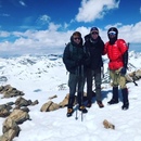
 John on top of Eolus!")
 Panorama overlooking North Eolus, Sunlight, and Windom")
")
 Giant mushrooms!")
|
| Comments or Questions | ||||||||||||
|---|---|---|---|---|---|---|---|---|---|---|---|---|
|
Caution: The information contained in this report may not be accurate and should not be the only resource used in preparation for your climb. Failure to have the necessary experience, physical conditioning, supplies or equipment can result in injury or death. 14ers.com and the author(s) of this report provide no warranties, either express or implied, that the information provided is accurate or reliable. By using the information provided, you agree to indemnify and hold harmless 14ers.com and the report author(s) with respect to any claims and demands against them, including any attorney fees and expenses. Please read the 14ers.com Safety and Disclaimer pages for more information.