Download Agreement, Release, and Acknowledgement of Risk:
You (the person requesting this file download) fully understand mountain climbing ("Activity") involves risks and dangers of serious bodily injury, including permanent disability, paralysis, and death ("Risks") and you fully accept and assume all such risks and all responsibility for losses, costs, and damages you incur as a result of your participation in this Activity.
You acknowledge that information in the file you have chosen to download may not be accurate and may contain errors. You agree to assume all risks when using this information and agree to release and discharge 14ers.com, 14ers Inc. and the author(s) of such information (collectively, the "Released Parties").
You hereby discharge the Released Parties from all damages, actions, claims and liabilities of any nature, specifically including, but not limited to, damages, actions, claims and liabilities arising from or related to the negligence of the Released Parties. You further agree to indemnify, hold harmless and defend 14ers.com, 14ers Inc. and each of the other Released Parties from and against any loss, damage, liability and expense, including costs and attorney fees, incurred by 14ers.com, 14ers Inc. or any of the other Released Parties as a result of you using information provided on the 14ers.com or 14ers Inc. websites.
You have read this agreement, fully understand its terms and intend it to be a complete and unconditional release of all liability to the greatest extent allowed by law and agree that if any portion of this agreement is held to be invalid the balance, notwithstanding, shall continue in full force and effect.
By clicking "OK" you agree to these terms. If you DO NOT agree, click "Cancel"...
Trailhead: Wild Basin Trailhead
Elevation gain: 5,300'
Distance: 22 miles
Start time: 3:45am
Return: 6:40pm
Climbers: sunny1 (Nancy), MtnHub (Doug)
Introduction:
I've now climbed Longs Peak over a dozen times. I try to climb it every year when I vacation in CO. And while I always enjoy repeating it, I'm also constantly on the lookout for something new as well. Since the landscape surrounding Longs has become very familiar to me, I've taken another look at some of the peaks in close proximity. Most of these peaks are not climbed with great regularity because they have such long approaches. To make an attempt on any of them, a climber must not be intimidated by distance or elevation gain.
The last time I was in the Wild Basin was well over 20 years ago. I hiked up to Thunder Lake but never did the right fork to the Lion Lakes. When I recently came across a trip report on Chiefs Head written by summers in 2010, their pictures and description intrigued me. It sounded very doable, albeit very long - over 20 miles. But at least 14 of those miles would be on good established trail, and the off-trail scrambling would be straightforward and relatively easy, with no route-finding issues to speak of.
Chiefs Head was also very appealing in that it lies on the Continental Divide overlooking both the Glacier Gorge as well as the Wild Basin. And it would give me another great perspective of Longs Peak and Meeker.
Knowing I would have a lot of trouble finding another partner willing to do such a long hike, I even considered attempting it solo. But I was a bit reluctant for safety's sake in case I became injured or got into any other kind of trouble. I know it would make my wife very anxious for me to be alone on such a long excursion since it is in such a remote area.
Over the last several years sunny1 has become a close friend to me and we have partnered together a few times in recent years. So I was elated when she asked if I was willing to give it a try! We set a climbing date for August 1.
The Climb:
Nancy is already waiting at the Wild Basin parking lot when I arrive at 3:30am. We are both psyched for a great day! It takes us a moment to find the actual trailhead in the dark, but by 3:45 we are on our way!
The trail to Lion Lakes has its share of rocks and roots and steep sections threatening to make you stumble, but I'm happy to note that there are also several places where it is fairly steady with an abundance of dirt and pine needles. I know these places will be welcome when we're walking out after a long day.
I'm not a big fan of hiking in the dark, even with a good headlamp, and starting so early makes it that much longer to endure. But eventually the early morning light breaks through the shadows and we can take the lamps off our heads. This is the time of day I especially love, when you can just begin to discern your surroundings without the aid of artificial light. Everything is so peaceful and calm and birds begin to sing their morning songs. Nancy setting a good pace with Chiefs Head in the background.
By the time we reach our first destination, Lion Lake No. 1, the morning sun is in full force. MtnHub coming up to Lion Lake No. 1 (photo by sunny1)
Mt. Alice towering over Lion Lake No. 1
The lower cliffs of Chiefs Head behind Lion Lake No. 1
We follow the trail around the first lake and begin to climb up a short headwall. We also find we need to climb around a small cliff band. On the left side of this cliff we discover access via a steep, rocky gully and climb up it to another shelf. Here we stop for a quick break and study what lies ahead. The short cliff band we had to skirt around.
We suspect Lion Lake No. 2 lies just above the next rim. Aiming for a grassy section to the right, we cross between two small snowfields. We soon reach Lion Lake No. 2 and we make another quick stop. Lion Lake No. 2 lies just above.
Looking ahead, we can now see the saddle between Alice and Chiefs Head. That's our future benchmark. But first we need to tackle the next rise, which should let us attain Snowbank Lake, the highest little alpine lake in this cirque at 11,521 feet. We spot lots of stubby krummholz now so we know we're getting close. Krummholz leading us to Snowbank Lake; the Alice/CH saddle in the distance.
sunny1 posing by Lion Lake No. 2
Snowbank Lake is true to its name with a curling snowbank dipping into its northern shore.
The report I read said to go around Snowbank from the southwest, but that route looks more difficult - thick krummholz to plow through and a couple of slanting snowfields heading right into the water's edge. Instead, we choose to go around on the northeast side hopping over rocks and steps and we do just fine. The rocky peninsula cutting across the southern part of the lake.
A look at Mt. Alice from the east side of Snowbank.
Once on the north side of Snowbank with a better view of the headwall and saddle, we take a minute to discuss our options. We could take a direct route and aim right for the saddle and avoid any backtracking. Going directly up to the right of the snowfield looks possible but the talus and scree looks pretty loose and icky to me. I suggest heading over to the long easy slope on the left, which offers a more gradual approach. The terrain looks much more steady and inviting as well. The terrain above Snowbank leading to the high ridge.
Nancy agrees, so we set our internal compasses for the softer ridge. When we reach the base of it we see three elk grazing near the crest. After they notice us hiking in their direction, they stop to stare at us for a few minutes but then saunter over to the other side. Three elk on the ridge with Mt. Alice as a nice backdrop.
MtnHub starting up the ridge. (photo by sunny1)
sunny1 coming up behind me.
The ridge offers an excellent vantage point of Mt. Alice. From this direction it closely resembles Longs Peak with its own Diamond face. Mt Alice from the ridge.
Close to the saddle.
McHenrys Peak peeking over the saddle.
Nancy following; Snowbank and Lion Lake 2 and Mt. Ortin in the distance.
MtnHub on the saddle with Powell and McHenrys Peak behind. (photo by sunny1)
Once we both finally reach the saddle we stop for a moment to assess the situation. Previously we had talked about hitting both summits if we felt up to it and the weather looked good. We have a bluebird day but we have also taken more time than anticipated getting to this point. The sharp hourglass ridge and northern slope to Alice's summit looks pretty daunting from this direction. It is only supposed to be Class 2, but from where we stand, it looks like you'll slide right off it should you slip. The hourglass ridge and northern slope of Mt. Alice.
Nancy states she only wants to go for CH but I'm torn between the two. Since we are so close to Alice right now, I ask her if she would mind us splitting up. I could tag Alice and then meet her either on CH or on her way back to the saddle. She agrees, but I sense a slight reluctance on her part to disclose her true feelings of misgiving.
I begin my boulder hopping quickly along the ridge crest towards Alice. When I get to the narrow section where the notch of the curving hourglass lies, I dislodge a couple of large rocks down the chute. The rocks are quite unstable here and I estimate it will take a lot of slow, careful going, testing all my holds to continue.
It unnerves me for a moment and my confidence takes a dive. I realize it will take me much longer to summit than I anticipated and I decide it's really not worth the effort at this point. I conclude I would much rather remain with Nancy and be content with just bagging CH.
So I retrace my steps along the saddle and follow behind Nancy who is a good ten to fifteen minutes ahead of me. But I do take a quick stop on the saddle to get a great shot of Powell and McHenrys Peaks with the Notch in between them. There is also an excellent view of Stone Man Pass from the west. Powell and McHenrys Peaks
Stone Man Pass
Looking at the West Ridge of Chiefs Head, I can just barely discern Nancy slowly making progress up the slope. The West Ridge of Chiefs Head; sunny1 is just barely visible (mid-frame, 2/3's from the left).
I eventually catch up with her near the top and we stop at a good vista overlooking Glacier Gorge. MtnHub taking in the views. (photo by sunny1)
McHenrys Peak and Arrowhead.
Glacier Gorge with Frozen Lake and The Spearhead in the foreground.
Half Mountain with Lumpy Ridge in the background.
On the other side: Snowbank and the Lion Lakes.
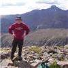
We continue the climb upward and finally reach the summit around noon, but we're disappointed in not finding a summit register. There is an uncapped tube but it only contains a grocery receipt dated a few days prior with 3 names written on the back. We lounge around enjoying the views, eating a snack, and we take a few pictures of each other on a balancing rock. It looks rather precarious but it's actually quite stable. MtnHub having fun on the 'balanced' rock. (photo by sunny1)
A new perspective on Longs, the Keyboard, and Pagoda. WOW!
After about half an hour we descend the way we came up. When we reach the saddle, we once again debate how we'd like to drop down to the basin. Nancy wants to try the gully, but once again, I'm very hesitant. It looks quite loose on such a steep slope I'm reluctant to risk it especially since it's already been a long day and I'm getting more fatigued. The last thing I want to do at this stage is slip and sprain something, or worse. The western cliffs of Chiefs Head, from the saddle.
And once again Nancy is kind enough to go along with me and we descend on the ridge we came up on. It is much kinder to my ankles and knees and I'm very grateful. It takes us close to an hour to reach Snowbank Lake again, but this time we skirt the lake the other way around, through the krummholz and short bluffs. There are a few tricky places but all in all, it's a fairly easy go. The two snowfields we need to cross are now soft enough to kick steps into. sunny1 coming out of the krummholz.
Lion Lake No. 1
Mt. Alice with a waterfall below the lakes.
One final look at Chiefs Head from Lion Lake No. 1
The hike out is uneventful. It is a long walk (7 miles), but having a groomed trail to tread on makes it good. We meet more people coming up than I expected. There were at least two couples heading up to camp near the Lion Lakes. By the time we near the waterfalls and bridges, there are several hikers taking to the trail as a late day hike.
I'm plenty tired but not as exhausted as I anticipate. It's been many years since I've taken a 20+ mile hike and I feel good that the body held up as well as it did. The bottoms of my feet feel the worst. I can't wait to get out of my boots and put on my Teva's.
Nancy has been an excellent partner, and a good companion. I'm grateful to have shared this hike with her and I think she feels the same. Until next year, I wish you all the best!
Thumbnails for uploaded photos (click to open slideshow):
I have been researching some of the 13ers in RMNP recently... both Alice and Chiefs Head look fun, just have to find the time and energy for a long day! Thanks for sharing.
But it looks like you and Nancy handled it without a problem. Not sure I am capable of a 14hr day but your pictures and description makes me want to try it.
Jay -- it was actually a 15hr day, but who's counting. It WAS long, and we were both on 'autopilot' the last couple of hours walking out -- like two walking zombies. Ha! But it was wonderful at the same time. We talked about doing the Mt Ortin SE ridge as it is supposed to be slightly shorter, but we really wanted to do this route. I think it is much more scenic since you go right by the lakes directly.
Doug, thanks for writing this up so nicely, I enjoyed looking at it through your perspective. It's a pleasure to read and re-live.
I really enjoyed the trip again, seated in my chair this time!
Gorgeous area and I was thrilled to hike with you again.
MANIMAL! You really rocked the summits this summer!!
Maybe we can get after Alice next summer? There are a few other ideas percolating...stay tuned
.. is correct! Thanks again for partnering this with me. I could go back there again next year if it works out. I don't think Alice would really be that bad, but I would definitely like to have a partner for it. Keep it on the backburner!
Thanks, Dave! Yeah, Nancy took a good one! Sorry we didn't get much in this year, but now that we know exactly where Lake Windsor is, we could maybe give it another try.
Doug: What a great report and a set of really cool pics! I've (on different occasions!)
done both Chiefs Head (via Sandbeach Lake, Mt. Orton, and the North Ridge) and Mt. Alice
(by the same route you look except I looped around to BG Pass and went back down that
way), so I really enjoyed a second look at that gorgeous part of RMNP. The view
into Glacier Gorge from the Chiefs's summit is truly stunning. Good going on getting
a picture of all three lakes (Lion 1, 2, and Snowbank), as I could never get quite the
right vantage point on my hikes. The "hour glass" ridge going up Alice demands a lot
of patience and energy (at least it did for me anyway), so I think you made the right
call to redirect your efforts toward Chief's Head. Thanks for letting us tag along.
Kevin
Andrew, coming from you, I'm deeply honored! But I'd never do it in winter (in reference to your amazing 100/100 report!)
Kevin -- good to hear from you! And I'm very impressed you did them both, even if it was on different days. Just getting back there once is a big commitment of time and energy. Going back a second time to get the other may be just shy of mental illness. (But I'm actually considering it for next year! Yeah, I've got the disease!)
This brings back fond memories... 8/18/2016 11:36am
...of climbing Chiefs Head from Thunder Lake via Orton Ridge, passing the upper end of Lion Lake No. 1. Nice job with your photos and for sticking with it on such a long day.
Caution: The information contained in this report may not be accurate and should not be the only resource used in preparation for your climb. Failure to have the necessary experience, physical conditioning, supplies or equipment can result in injury or death. 14ers.com and the author(s) of this report provide no warranties, either express or implied, that the information provided is accurate or reliable. By using the information provided, you agree to indemnify and hold harmless 14ers.com and the report author(s) with respect to any claims and demands against them, including any attorney fees and expenses. Please read the 14ers.com Safety and Disclaimer pages for more information.
Please respect private property: 14ers.com supports the rights of private landowners to determine how and by whom their land will be used. In Colorado, it is your responsibility to determine if land is private and to obtain the appropriate permission before entering the property.


")


")


")


.")
")


")


 Nancy setting a good pace with Chiefs Head in the background.")
 Mt. Alice towering over Lion Lake No. 1")
 The lower cliffs of Chiefs Head behind Lion Lake No. 1")
 Lion Lake No. 2 lies just above.")
 Krummholz leading us to Snowbank Lake; the Alice/CH saddle in the distance.")
 sunny1 posing by Lion Lake No. 2")
 Snowbank Lake is true to its name with a curling snowbank dipping into its northern shore.")
 The rocky peninsula cutting across the southern part of the lake.")
 A look at Mt. Alice from the east side of Snowbank.")
 The terrain above Snowbank leading to the high ridge.")
 Three elk on the ridge with Mt. Alice as a nice backdrop.")
 sunny1 coming up behind me.")
 Mt Alice from the ridge.")
 Close to the saddle.")
 McHenrys Peak peeking over the saddle.")
 Nancy following; Snowbank and Lion Lake 2 and Mt. Ortin in the distance.")
 The hourglass ridge and northern slope of Mt. Alice.")
 Powell and McHenrys Peaks")
 Stone Man Pass")
 The West Ridge of Chiefs Head; sunny1 is just barely visible (mid-frame, 2/3's from the left).")
 McHenrys Peak and Arrowhead.")
 Glacier Gorge with Frozen Lake and The Spearhead in the foreground.")
 Half Mountain with Lumpy Ridge in the background.")
 On the other side: Snowbank and the Lion Lakes.")
 The western cliffs of Chiefs Head, from the saddle.")
 sunny1 coming out of the krummholz.")
 Lion Lake No. 1")
 The short cliff band we had to skirt around.")
 Mt. Alice with a waterfall below the lakes.")
 One final look at Chiefs Head from Lion Lake No. 1")
 MtnHub coming up to Lion Lake No. 1 (photo by sunny1)")
 MtnHub starting up the ridge. (photo by sunny1)")
 MtnHub on the saddle with Powell and McHenrys Peak behind. (photo by sunny1)")
 MtnHub having fun on the 'balanced' rock. (photo by sunny1)")
 MtnHub taking in the views. (photo by sunny1)")
 A new perspective on Longs, the Keyboard, and Pagoda. WOW!")