| Peak(s): |
Mt. Yale - 14,200 feet |
| Date Posted: | 08/09/2007 |
| Date Climbed: | 08/05/2007 |
| Author: | Greenhouseguy |
| Peak(s): |
Mt. Yale - 14,200 feet |
| Date Posted: | 08/09/2007 |
| Date Climbed: | 08/05/2007 |
| Author: | Greenhouseguy |
| Mt. Yale - Southwest Slopes from Denny Creek |
|---|
|
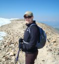
Mt. Yale 14,196 Feet (21st Highest in Colorado) Southwest Slopes from Cottonwood Pass Denny Creek Trailhead, 9,990 Feet August 5th, 2007 8.0 Miles Roundtrip 4,100 Feet Elevation Gained Greenhouseguy, son Ian, and KeithK Mt. Yale is in the Collegiate Peaks Wilderness Area about 12 miles west of Buena Vista. It was first climbed in 1869 by a team of Harvard University geologists led by Josiah Whitney. The peak was named for Whitney's alma mater, Yale University. We left from the Morrison Park-n-Ride at 3:30 a.m., and cruised down CO285 to Buena Vista. We arrived at a truck stop in Byoonie at about 6:00, had a bite to eat, and were at the Denny Creek Trailhead by 6:15. The Denny Creek Trailhead is among the easiest to reach with a 2WD vehicle. We turned off of CO24 at County Rd. 306 in the center of Buena Vista; signs directed us to Cottonwood Pass. The road is paved, and is in good shape. We arrived at the trailhead after a scenic 12-mile drive. The parking lot at the trailhead was well-marked and easy to find.  The Denny Creek Trailhead The trail began at the eastern edge of the parking lot. The rocky trail seemed steep at first, but we quickly found our stride. We signed in at the trail register, which was a short way up the trail. A trailside sign reminded us that we were in the Collegiate Peaks Wilderness area in the San Isabel National Forest.  Collegiate Peaks Wilderness Area sign near the Denny Creek Trailhead The lower trail was wide and the grade was reasonable.  Trail conditions on the lower portion of the standard route After about a mile, the trail crossed over Denny Creek. The log bridge over the creek was not immediately obvious; it was hidden behind some trees to the left.  Bridge over Denny Creek After about another 1/4th of a mile, the trail split. The left branch went towards Brown's Pass and Hartenstein Lake, while the right branch headed towards Mt. Yale's summit. An obvious sign marked the trail junction.  Sign at the trail junction The trail continued up Delaney Gulch to about 11,500 feet, and then it turned abruptly to the southeast. The trail was fairly level as it approached treeline.  Trail conditions at about 11,800 feet At about 11,900 feet, the trail turned to the northeast for most of the remainder of the hike. When we reached 12,000 feet, the trail got markedly steeper. The remainder of the hike came into view, and it was imposing.  Upper portion of Mt. Yale's standard route Mascot Peak appeared to the left (southeast) of Mt. Yale's summit.  Mascot Peak seen from Mt. Yale's standard route We continued up the slope from about 12,100 feet to about 13,100 feet. At 13,100 feet, the steep slope gave way to the steeper saddle that led to the northwest end of the summit ridge. The side of the saddle was mostly scree, and some of it was pretty loose. Hikers had braided a number of trails while attempting to find better footing. This was probably the most challenging portion of the trail.  Working our way up the slope towards the saddle  Higher on Mt. Yale's Southwest Slopes A pair of pikas were busily gathering grass along the upper portion of the trail. Their hyperactive behavior was amusing to watch. I caught one in a majestic pose on a lichen-covered rock.  Pika sitting on a rock alongside the trail We continued laboring our way up the steep side of the saddle. I became encouraged as we approached the top.  Approaching the top of the saddle We topped out on the saddle at 13,900 feet. The trail effectively ended at this point; the summit ridge was a massive jumble of talus.  Mt. Yale's summit ridge I noticed that there was a cairned route through the talus on the northeast side of the ridge; actually, there were cairned routes on both sides of the ridge. I followed the route on the left (northeast) side, and had no difficulties. Hikers seldom agree on class ratings, but I would rate it as a solid Class 2+ with no exposure. A bad fall would simply wedge a hiker between rocks. My son Ian chose the nonconformist's path; he decided to follow the crest of the ridge. He reported no difficulties  Following the cairned route on the northeast side of Mt. Yale's summit ridge. Ian is on the ridge's crest. Cairns are circled for emphasis The summit ridge involved perhaps a quarter mile of fun light scrambling. The true summit eventually came into view.  Mt. Yale's summit Shavano and Tabeguache should have been visible to the south, but dark clouds and haze limited the view. Fortunately, no lightning or thunder accompanied the clouds.  View to the south from Mt. Yale's summit Point 13,123 and other lower peaks curved to the southeast, and the city of Buena Vista appeared through the haze.  Avalanche Gulch and the city of Buena Vista viewed from Mt. Yale's summit A number of Sawatch fourteeners were visible to the north. The closest were Mt. Harvard and Mt. Columbia; to their north were Mt. Oxford, Mt. Belford, and Mt. Missouri. Huron Peak could be seen to the northwest, and Mt. Elbert was on the distant horizon.  Sawatch fourteeners north of Mt. Yale The Elks Range was far to the west. It was difficult to make out individual peaks through the haze.  Western view from Mt. Yale's summit Mt. Princeton, which is one foot taller than Mt. Yale, was the nearest fourteener to the southeast. This beautiful peak dominates Buena Vista's western skyline.  Mt. Princeton viewed from Mt. Yale's summit Ian and I posed for a shot on the summit, and Keith joined us a few minutes later.  Greenhouseguy and Ian on Mt. Yale's summit We chatted with other hikers and enjoyed the views, but I did not want to linger on the summit for very long. The dark clouds troubled me, even though there was no thunder or lightning. We headed down on the southwest side of the summit ridge, which was nicely cairned. It seemed a bit easier than our ascent on the opposite side.  Descending the southwest side of Mt. Yale's summit ridge. Cairns are circled in black I paused on the summit ridge to gaze down the trail. Treeline seemed pretty far away, and we had a lot of altitude to lose. I was confident that we could reach safety quickly if the weather took a turn for the worse.  Looking down the trail from the saddle below Mt. Yale's summit. The trail is highlighted in black When we reached the bottom of the saddle, I caught a glimpse of The Three Apostles.  The Three Apostles viewed from Mt. Yale's Southwest Slopes Ian made some comment about the high fiber content of Clif Bars, and left us in the dust. Keith and I worked our way down the slope at a more leisurely pace. We saw a number of marmots grazing on the tundra, and a particularly brave one came within about four feet of Keith. The rest of them showed much more caution.  Marmot on Mt. Yale's Southwest Slopes The wildflowers were past their prime, but the tundra was still colorful. At about 11,700 feet, I saw a lone Gentian beside the trail. Avens, red and yellow Indian Paintbrush, Groundsel, Cinquefoil, Wood's Rose, Sky Pilots, and Asters provided flashes of color wherever they popped up.  Gentian alongside the trail on Mt. Yale A few raindrops fell, but not even enough to cool us off. A single, tremendously loud thunderclap echoed down the gulch as we reached the car. I realized how lucky we were that the weather had not kept us from the summit. We celebrated with char-broiled burgers at K's in Buena Vista, and headed back home with high hopes of being able to recover in time for work in the morning. |
| Comments or Questions | |||||||||
|---|---|---|---|---|---|---|---|---|---|
|
Caution: The information contained in this report may not be accurate and should not be the only resource used in preparation for your climb. Failure to have the necessary experience, physical conditioning, supplies or equipment can result in injury or death. 14ers.com and the author(s) of this report provide no warranties, either express or implied, that the information provided is accurate or reliable. By using the information provided, you agree to indemnify and hold harmless 14ers.com and the report author(s) with respect to any claims and demands against them, including any attorney fees and expenses. Please read the 14ers.com Safety and Disclaimer pages for more information.