| Peak(s): |
Pyramid Peak - 14,029 feet "Thunder Pyramid" - 13,944 feet "Lightning Pyramid" - 13,729 feet |
| Date Posted: | 08/12/2007 |
| Modified: | 09/28/2010 |
| Date Climbed: | 08/10/2007 |
| Author: | Jason Halladay |
| Peak(s): |
Pyramid Peak - 14,029 feet "Thunder Pyramid" - 13,944 feet "Lightning Pyramid" - 13,729 feet |
| Date Posted: | 08/12/2007 |
| Modified: | 09/28/2010 |
| Date Climbed: | 08/10/2007 |
| Author: | Jason Halladay |
| Pyramid Peak (14,018') traverse to Thunder Pyramid (13,932') and Point 13,722' |
|---|
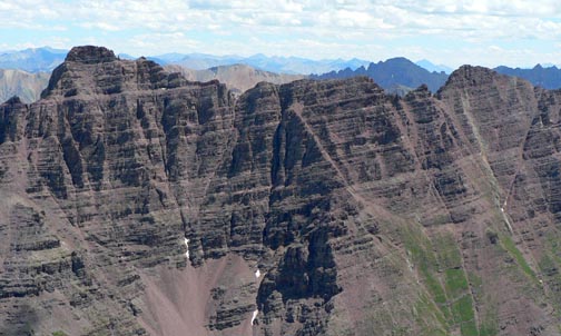 *Route: Northwest Ridge on Pyramid, traverse to Thunder Pyramid and traverse to Point 13,722', descend west side of Point 13,722' *Trailhead: Maroon Lake TH at 9600' *Partner: Bill Geist *Distance/Vertical/Time (RT): ~ 12.35 miles, ~5,520', 10:21:36 hours *Additional Stuff:My Picasa Web Album Traverse from Pyramid Peak to Thunder Pyramid. *Classic* (Just kidding.) We had stayed the night at Aron's house in Aspen Thursday night and made the ~20 minute drive to the trailhead Friday morning to start our hike around 6:45am. Our plan for the day was to climb Pyramid Peak, one of two remaining 14ers for Bill on his list, and hopefully climb Thunder Pyramid as well. Earlier in the week we had begun to consider the best way to climb both of these peaks and, from looking at the maps, the connecting ridge was the obvious line. However, having spent a good amount of time in the Elks we knew how poor the rock quality is and we'd never heard anyone talk about the connecting ridge. Some Googling didn't yield any relevant information so I posted a query on 14erWorld.com. That post resulted in an amazing photograph of the ridge from the east, a comment from Ken Nolan that he'd heard of someone doing it and a thread on 14ers.com from a guy stating he'd done it in the mid-80s. The comment from Nolan was encouraging but the photograph from Kane's friend was less encouraging"at least two major notches, plenty of crappy looking rock and some intimidating exposures. But it was the post from the user on 14ers.com that was the least encouraging"4.5 hours to travel roughly a mile, hand holds that came off in your hand and "climbing on the most rotten junk that I have ever been on. I would not do this traverse again..." With this in mind, we left the trailhead with a 9mm, 30m rope, our harnesses and definitely our helmets and figured we'd take a look at the ridge and make the decision once we were up there. We enjoyed a nice bit of alpenglow on the Maroon Bells as we started our hiked and were surprised at the lack of photographers hunched around Maroon Lake, only three, when we passed by. This would be Bill's third attempt on Pyramid Peak having been snowed off twice on fall trips in the past three years. But today was a different story"it was shaping up to be a perfect day. The hiking into the basin at 12,000' below Pyramid's north face went smooth thanks to the awesome CFI-improved trail that now exists. The first time I climbed Pyramid Peak had been in July of 2001 and the trail was a tough, straight-up affair at that time. We marveled at the huge blocky steps, nice switchbacks and clean trail that is now in place. Quality work! On our hike in I suggested we check out the Northwest Ridge route rather than the standard Northeast Ridge route since I had been up that way before. Bill was, as usual, interested in the less-standard route so at 8:00am at roughly 12,000' we left the good trail and headed west up the steep, loose wide gully. 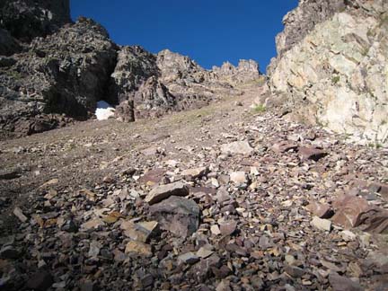 Looking up the wide gully that gets one to the NW ridge proper. We stayed on big blocks when we could and then I moved to the gully's right side to utilize the hand holds on the solid rock of the gully wall. Bill went to the left side of the gully so we'd away separated to keep from knocking rocks on each other. My route appeared to be better than Bill's but that's all a matter of opinion. I enjoyed more solid rock near the top and reached the saddle at 12,700' at 8:40am. Once on the ridge the travel became much more pleasant and when Bill arrived on the ridge we snacked for a bit before heading up further. We followed a decent trail into a fairly narrow gully and peered around the corner to another gully. We liked the looks of the second one better because, while steeper and definitely fourth-class terrain, the rock was more solid. 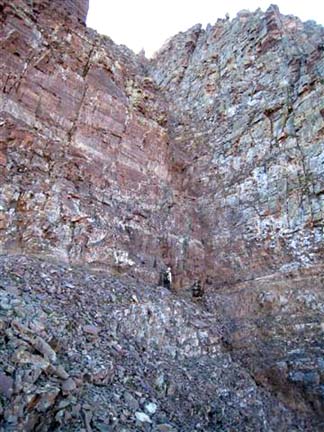 Route finding is pretty crucial on the NW ridge. We climbed the gully in this photo and it worked well. We scrambled up the gully and continued traversing to our right when the terrain suggested it and eventually found another short gully that led to another good traversing ledge to the right. 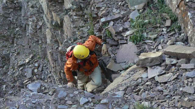 Typical loose rock scrambling on the NW ridge route. Ultimately passed under the summit block and ended up on the south ridge of Pyramid just a few hundred feet from the summit. Heading north on the south ridge we climbed one short, 12-foot section that felt steep enough and hard enough to qualify as low fifth-class before enjoying a bit more exposed scrambling to the summit at 10:00am. 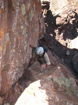 Bill climbing up the 12-foot section of fifth class action to the summit proper. We enjoyed roughly ten minutes of fantastic views before another couple of guys, Scott and Morey, came up from the Northeast Ridge. We chatted with them for a bit and they asked how our route compared to the route they had just ascended. I told them my opinion"the Northwest ridge offer much better rock but requires a better sense of route-finding than is necessary on the Northeast Ridge. They suggested they would consider descending that way so Bill and I cautioned them as we gave them beta on how it went. (We would see them on the summit of Maroon Peak the following day and found out they missed the traversing to the northwest and ended up descending straight down the west face to the valley above Crater Lake!) On the summit Bill and I discussed the idea of traversing the connecting ridge to Thunder Pyramid. Based on what we had read in the one post on 14ers.com, we were both a bit leery of the ridge. However, the ridge didn't look that bad and over the years we have both learned to treat information from anonymous-to-us climbers cautiously. Everyone's skill levels, experience and comfort levels differ and one should never take "anonymous" beta at face value. Bill still seemed luke-warm to the idea but when I said, "Let's do it", he was up for it. We left the summit of Pyramid a little after 10:30am and reversed the moves that we had previously made back down off the summit block. The going was pretty smooth for the first 15 minutes but the business started right after that. 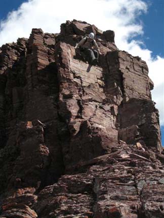 Down climbing on one of the early drops. Trying to stay on the ridge as much as possible we quickly got cliffed-out and had to back track to a small notch and bypass the first drop on the east side. The rock was loose but not out of character for for this area. Back on the ridge we again got stymied by the first of two major notches on the ridge. The west side was out of the question as it was a huge drop so we headed left. On the east side we started working our way down on very tenuous, extremely loose rock. It was loose rock on loose rock! Add to that some serious exposure and we became intently focused on the task at hand. Some small drops of about eight feet at a time required cleaning of surface rock to get to the semi-solid rock underneath. We took turns going down short sections at a time because we were both, unavoidably, knocking down large quantities of rock. We were doing plenty of what our friend, Theresa, calls "butt climbing". Cautiously we scooted down off small ledge after small ledge and slowly worked our way back to the bottom of the large notch. 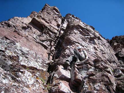 Bill stylishly "butt climbing" around the crux of the traverse. Getting into the notch required one last bit of real down climbing on the west side of the ridge but at least the rock on this section was more solid than what we had just descended on the east side. When we reached the notch we took a moment to relax and calm our nerves. It had been damn dicey. We commented that if there was much more of that on the traverse this was not only going to take a very long time but we'd be mentally shot by the time we reached Thunder Pyramid.  Looking back at the crux section of the traverse. Thankfully, as we continued, we found that the section we just descended was definitely the crux of the traverse and that much of the rest of the ridge was better"still not great but better. Actually, the rest of the traverse flowed rather well. We stayed on good ledges on the ridge's east side about 50-100 feet below the ridge crest for much of the traverse but often found ourselves back on the crest. 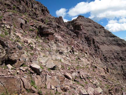 Working along on very good ledges on the ridge's east side. Just when it looked like we'd get cliffed-out again as we came upon a drop, a route down would appear. For almost all of the remaining drops, including the second major notch just below the summit of Thunder Pyramid, we'd down climb decent rock on the west side of the ridge. About two-thirds of the way we dropped into a notch that offered an awesome view and commanding stance with Maroon Bells as the back drop. 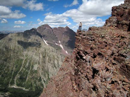 Totally posing but with a view like this how can you not pose? At 11:55am we descended down into the last major notch on the traverse and looked up the ridge to Thunder Pyramid's summit. It looked steep and sustained on the ridge proper but it looked like we could go to the left or right to reach the summit. As we got up closer we found the rock on the ridge to indeed be steep but surprisingly solid. In fact, it looked like some super fun climbing! So we went straight up and savored some enjoyable low-fifth class climbing for about twenty feet before reaching good ground and cruising to the summit at 12:10pm. 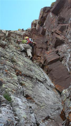 Some final bit of climbing just below Thunder Pyramid's summit. Looking back at the ridge we were rather surprised it went so quickly taking just a bit more than an hour and a half to get across. 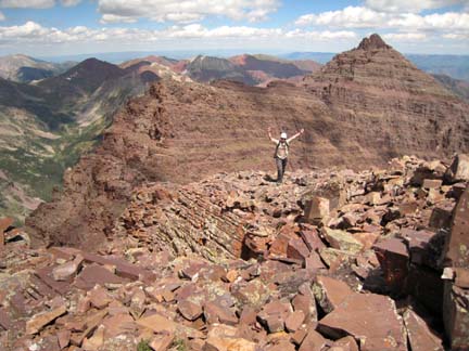 Bill celebrates a successful traverse from Pyramid to Thunder Pyramid. Granted, we still had to get down and, as we would find out, the descent isn't fun. Bill and I came to this conclusion"the rock in this area takes a unique skill set of climbing. Certainly the oft repeated saying "Pull down not out", holds true but there's more to it than that. Not only did we test and retest key holds during the traverse, we found we needed to stay balanced on the rock trying to equally weight each hand and foot as much as possible. Also, I found myself constantly being focused on the "what next" plan. If one hand popped, what would I do to react? If the block I was standing on shifted, which way would I move or jump? So since the traverse went so quickly and it was barely after noon, we decided to traverse south to Point 13,722' (a.k.a. Lightning Pyramid) before heading down. But first we enjoyed some time on the summit of Thunder Pyramid. (Had we done just a tiny bit of information gathering about Lightning Pyramid ahead of time, we would have continued south on the ridge to Point 13,631'. Damn.) The ridge to Lightning Pyramid was an order of magnitude better than the ridge between Pyramid and Thunder Pyramid, requiring a few fourth class moves, but otherwise went well and we reached the summit of 13,722' at 1:15pm. Because the register can had been left cap-side down, water had run into the register can and soaked the paper. No worries, though, it was a truly awesome day so we hung the paper out to dry while we napped for about 30 minutes. The paper dried up, we signed in and backtracked to the saddle between Thunder Pyramid and 13,722'. The descent from the saddle down the gully and then on the south side of the gully was painstakingly tedious and slow but fairly obvious. It involved super-loose third and fourth class action on sometimes small, sometimes larger blocks on a slick surface underneath. 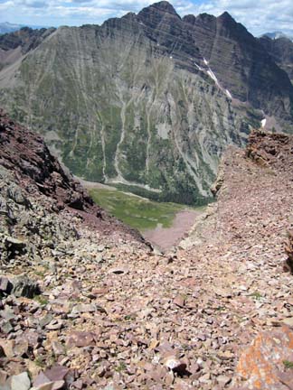 Looking down the descent gully from the saddle between Thunder Pyramid and Point 13,722'. An ascent of this line would not be exactly awesome. At 2:45pm we finally reached solid, grassy ground and took a moment to empty our shoes and enjoy the afternoon a bit more. We could see the trail next to West Maroon Creek down in the valley and picked our way down through a few decent-sized cliff bands and then did some bushwhacking through willows, bushes and small trees before finally reaching the solid trail at 3:45pm. During the day we had seen an orange-yellow helicopter making numerous trips up the valley towards the south ridge of Maroon Peak. As we hiked out we came across a SAR member who told us there had been a recovery going all day. We later learned a 27 year-old male climber had fallen while on the south ridge of Maroon Peak and had died. This was sobering news. It also reminded us of the dangers of hiking and climbing these mountains and made us even more appreciable of the fact we had just returned safely from our outing. |
| Comments or Questions | |||||||||||||||||||||
|---|---|---|---|---|---|---|---|---|---|---|---|---|---|---|---|---|---|---|---|---|---|
|
Caution: The information contained in this report may not be accurate and should not be the only resource used in preparation for your climb. Failure to have the necessary experience, physical conditioning, supplies or equipment can result in injury or death. 14ers.com and the author(s) of this report provide no warranties, either express or implied, that the information provided is accurate or reliable. By using the information provided, you agree to indemnify and hold harmless 14ers.com and the report author(s) with respect to any claims and demands against them, including any attorney fees and expenses. Please read the 14ers.com Safety and Disclaimer pages for more information.


